The Arabian Sea is a region of sea in the northern Indian Ocean, bounded on the west by the Arabian Peninsula, Gulf of Aden and Guardafui Channel, on the northwest by Gulf of Oman and Iran, on the north by Pakistan, on the east by India, and on the southeast by the Laccadive Sea and the Maldives, on the southwest by Somalia. Its total area is 3,862,000 km2 (1,491,000 sq mi) and its maximum depth is 4,652 meters (15,262 ft). The Gulf of Aden in the west connects the Arabian Sea to the Red Sea through the strait of Bab-el-Mandeb, and the Gulf of Oman is in the northwest, connecting it to the Persian Gulf.
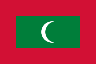
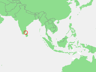
The Maldives, officially the Republic of Maldives, and historically known as Maldive Islands, is a country and archipelagic state in South Asia in the Indian Ocean. The Maldives is named after the main island and capital, Malé. The Maldives is southwest of Sri Lanka and India, about 750 kilometres from the Asian continent's mainland. The Maldives' chain of 26 atolls stretches across the equator from Ihavandhippolhu Atoll in the north to Addu Atoll in the south.

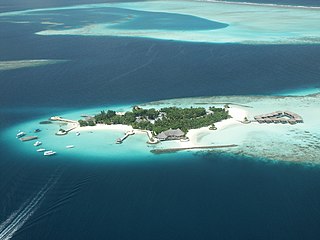
Maldives is an island country in the Indian Ocean, South Asia, south-southwest of India. It has a total land size of 298 km2 (115 sq mi) which makes it the smallest country in Asia. It consists of approximately 1,190 coral islands grouped in a double chain of 26 atolls, spread over roughly 90,000 square kilometers, making this one of the most geographically dispersed countries in the world. It has the 31st largest exclusive economic zone of 923,322 km2 (356,497 sq mi). Composed of live coral reefs and sand bars, the atolls are situated atop a submarine ridge, 960 km (600 mi) long that rises abruptly from the depths of the Indian Ocean and runs from north to south. Only near the southern end of this natural coral barricade do two open passages permit safe ship navigation from one side of the Indian Ocean to the other through the territorial waters of Maldives. For administrative purposes the Maldives government organized these atolls into twenty-one administrative divisions.

The Maldives are formed by 20 natural atolls, along with a few islands and isolated reefs today which form a pattern stretching from 7 degrees 10′ North to 0 degrees 45′ South. The largest of these atolls is Boduthiladhunmathi, while the atoll containing the most islands is Huvadhu.
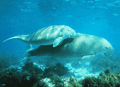
The Gulf of Mannar is a large shallow bay forming part of the Laccadive Sea in the Indian Ocean with an average depth of 5.8 m (19 ft). It lies between the southeastern tip of India and the west coast of Sri Lanka, in the Coromandel Coast region. The chain of low islands and reefs known as Adam’s Bridge or Rama Setu, which includes Mannar Island, separates the Gulf of Mannar from Palk Bay, which lies to the north between India and Sri Lanka. The estuaries of Thamirabarani River and Vaippar River of South India and the Malvathu Oya of Sri Lanka drain into the Gulf. The dugong is found here.

Minicoy, locally known as Maliku, is an island in Lakshadweep, India. Along with Viringili, it is on Maliku atoll, the southernmost atoll of Lakshadweep archipelago. Administratively, it is a census town in the Indian union territory of Lakshadweep. The island is situated 425 km west of Trivandrum, the capital city of Kerala.

Lakshadweep is a union territory of India. It is an archipelago of 36 islands divided into three island subgroups: the Laccadive Islands in the middle with the Amindivi Islands in the north separated roughly by the 11th parallel north and the atoll of Minicoy to the south separated by the Nine Degree Channel along the 9th parallel north. The islands are sandwiched between the Arabian Sea to the west and the Laccadive Sea to the east with the islands located about 220–440 km (140–270 mi) off the Malabar Coast of mainland India.
The Gulf of Mannar Marine National Park is a protected area of India consisting of 21 small islands (islets) and adjacent coral reefs in the Gulf of Mannar in the Indian Ocean. It lies 1 to 10 km away from the east coast of Tamil Nadu, India for 160 km between Thoothukudi (Tuticorin) and Dhanushkodi. It is the core area of the Gulf of Mannar Biosphere Reserve which includes a 10 km buffer zone around the park, including the populated coastal area. The park has a high diversity of plants and animals in its marine, intertidal and near shore habitats. Public access inside the park is limited to glass-bottom boat rides. It was established as a National Park in 1986.

Maldives fish is cured tuna traditionally produced in Maldives. It is a staple of the Maldivian cuisine, Sri Lankan cuisine, and the cuisine of the Southern Indian states and territories of Lakshadweep, Kerala and Tamil Nadu, and in the past it was one of the main exports from Maldives to Sri Lanka, where it is known as umbalakaḍa (උම්බලකඩ) in Sinhala and masikaruvadu in Tamil. It is also produced in small scale using traditional methods in Lakshadweep Islands in India. It is known as massmin in Lakshadweep.

Kadmat Island, also known as Cardamom Island, is a coral island belonging to the Amindivi subgroup of islands of the Lakshadweep archipelago in India. Measuring 9.3 kilometres (5.8 mi) in length, the island has a lagoon with a width of 1.5 kilometres (0.93 mi) covering an area of 25 square kilometres (9.7 sq mi). The ecological feature of the island is of coral reef with seagrass, and marine turtles which nestle here. The Ministry of Environment and Forests (India) has notified the island as a marine protected area for ensuring conservation of the island's animal, plant, or other type of organism, and other resources.
The fishing industry in the Maldives is the island's second main industry. According to national tradition in the words of former President Maumoon Abdul Gayoom, "Fishing is the lifeblood of our nation, it is inborn. From the soil on which we live, to the sea around us, it remains an integral part of our existence. Fishing, and our country and its people, [are] one and shall remain inseparable forever." The Maldives has an abundance of aquatic life and species of fish. Common are tuna, groupers, dolphin fish, barracuda, rainbow runner, trevally and squirrelfish and many more. Aside from being of essential importance to the economy, fishing is also a popular recreational activity in the Maldives, not only among locals but by tourists. The islands have numerous fishing resorts which cater for these activities.

Maldivians are an Indo-Aryan ethnic group and nation native to the historic region of the Maldive Islands, present day Republic of Maldives and the island of Minicoy in Union Territory of Lakshadweep, India. Maldivians share one culture and speak the Maldivian language, which is a member of the southern group of Indo-Aryan languages. For ethnographic and linguistic purposes as well as geopolitical reasons, anthropologists divide the Maldivian people into three subgroups.

The Maldives, officially the Republic of Maldives, is a small archipelagic state in South Asia. It lies in the Indian Ocean southwest of Sri Lanka and India, about 700 kilometres (430 mi) from the Asian continent's mainland. The chain of 26 atolls stretches across the Equator from Ihavandhippolhu Atoll in the north to Addu Atoll in the south. The land area is roughly 298 square kilometres. Malé is the capital.

Maldivian, also known by its endonym Dhivehi or Divehi, is an Indo-Aryan language spoken in the South Asian island country of Maldives and on Minicoy Island, Lakshadweep, a union territory of India.
Cherbaniani Reef, also known as Beleapani Reef, is a coral atoll belonging to the Amindivi Subgroup of islands of the Union Territory of Lakshadweep, India. It has a distance of 1,880 km (1,170 mi) south of the city of Delhi.

Coral reefs in India are one of the most ancient and dynamic ecosystems of India. The coral reefs not only provide a sanctuary to a myriad of marine life but also play a key role in protecting the coastline from erosion. India has about 7517 km of coastline including islands but mainland coast is 6100 km.
The coastline of Tamil Nadu is located on the southeast coast of Indian Peninsula, and forms a part of Coromandel Coast of Bay of Bengal and Indian Ocean. It is 1076 km long and is the second longest coastline in the country after Gujarat. Chennai, the capital of the state and an important commercial and industrial center in the country is located in the northern part of the coast with Kanniyakumari, forming the southern tip where Indian Ocean, Bay of Bengal and Arabian Sea meet. It also shares maritime border with Sri Lanka across the Palk strait in Gulf of Mannar. The coastal corridor consists of 14 districts with 15 major ports and harbors, sandy beaches, lakes and river estuaries. Tamil Nadu is the only state in India with territory on both the eastern and western coastlines.

Siganus insomnis, the bronze-lined spinefoot, is a species of marine ray-finned fish, a rabbitfish belonging to the family Siganidae. It is found in the northern central Indian Ocean. It had formerly been confused with S. lineatus, but was recognized as a separate species in 2014.

Very Severe Cyclonic Storm Ockhi was a strong tropical cyclone that devastated parts of Sri Lanka and India in 2017, and was the most intense tropical cyclone in the Arabian Sea since Cyclone Megh in 2015. The ninth depression, and the third and strongest named storm of the 2017 North Indian Ocean cyclone season, Ockhi originated from an area of low pressure that formed over the southwest Bay of Bengal on November 28. The storm organized into a Depression off southeast coast of Sri Lanka on November 29, causing damage to property and life in Sri Lanka while passing by. Due to high atmospheric moisture and warmer oceanic surface temperature between Sri Lanka and Kanyakumari in mainland India, Ockhi intensified into a cyclonic storm on November 30.

The Maldives–Lakshadweep–Chagos Archipelago tropical moist forests is a tropical moist broadleaf forest ecoregion in South Asia. It spans a chain of coralline islands in the Indian Ocean, including Lakshadweep, a union territory of India; the Maldives, an independent country; and the British Indian Ocean Territory, an overseas territory of the United Kingdom.


