Dal is a freshwater lake in Srinagar, the summer capital of Jammu and Kashmir in Indian-administered Kashmir. It is an urban lake, the second largest lake in Jammu and Kashmir, and the most visited place in Srinagar by tourists and locals. It is integral to tourism and recreation in the Kashmir valley and is variously known as the "Lake of Flowers",[1] "Jewel in the crown of Kashmir"[2] or "Srinagar's Jewel".[3] The lake is also an important source for commercial operations in fishing and water plant harvesting.[4][5][6]
The shore line of the lake, about 15.5 kilometres (9.6mi), is encompassed by a boulevard lined with Mughal era gardens, parks, houseboats and hotels. Scenic views of the lake can be witnessed from the shore line Mughal gardens, such as Shalimar Bagh and Nishat Bagh built during the reign of Mughal Emperor Jahangir,[7] and from houseboats cruising along the lake in the colourful shikaras.[8] During the winter season, the temperature can sometimes reach as low as −11°C (12°F), freezing the lake.[6][9]
The lake covers an area of 18 square kilometres (6.9sqmi) and is part of a natural wetland which covers 21.1 square kilometres (8.1sqmi), including its floating gardens. The floating gardens, known as "Rad" in Kashmiri, blossom with lotus flowers during July and August. The wetland is divided by causeways into four basins; Gagribal, Lokut Dal, Bod Dal and Nigeen (although Nigeen is also considered as an independent lake).[10]Lokut Dal and Bod Dal each have an island in the centre, known as Rupa Lank (or Char Chinari) and Sona Lank respectively.[9][11]
At present, the Dal and the Mughal gardens on its periphery are undergoing intensive restoration measures to fully address the serious eutrophication problems experienced by the lake. Massive investments of approximately US$275 million (₹ 11billion) are being made by the Government of India to restore the lake to its original splendour.[6][9][11][12][13]
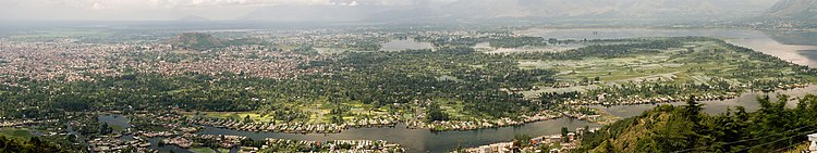
View of Dal Lake and the city of Srinagar from Shankaracharya Hill
History
Dal is mentioned as Mahasarit (Sanskrit: महासरित्) in ancient Sanskrit texts. Ancient history records mention that a village named Isabar to the east of Dal was the residence of goddess Durga.[14] This place was known as Sureshwari on the bank of the lake, which was sourced by a spring called the Satadhara. The name "Sureshwari" refers to the goddess Parvati, suggesting that the lake was once considered sacred and possibly associated with the goddess.[15][14]
During the Mughal period, the Mughal rulers of India designated Kashmir, Srinagar in particular, as their summer resort.[16][17] They developed the precincts of the Dal in Srinagar with sprawling Mughal-type gardens and pavilions as pleasure resorts to enjoy the salubrious cool climate.[16] After the death of Aurangzeb in 1707, which led to the disintegration of the Mughal Empire,[18]Pashtun tribes in the area around the lake and city increased, and the Afghan Durrani Empire ruled the city for several decades.[19] In 1814 a significant part of the Kashmir valley, including Srinagar, was annexed from the Afghans by Maharaja Ranjit Singh to his kingdom, and the Sikhs grew in influence in the region for 27 years.[20][21]
During the Dogra Raj, Srinagar became the capital of Dogra territory, attracted by the cool climate of the Kashmir valley, amidst the back drop of the majestic snow covered Himalayan ranges. The lake precincts experience temperatures in the range of 1–11°C (34–52°F) during winter and 12–30°C (54–86°F) during the summer season. The lake freezes when temperatures drop to about −11°C (12°F) during severe winter.[6] Although the DograMaharaja of Kashmir restricted the building of houses in the valley, the British circumvented this rule by commissioning lavish houseboats to be built on the Dal. The houseboats have been referred to as, "each one a little piece of England afloat on Dal."[22]
After the independence of India, the Kashmiri Hanji people have built, owned and maintained these houseboats, cultivating floating gardens and producing commodities for the market, making them the centre of their livelihoods. The houseboats, closely associated with Dal also provide accommodation in Srinagar. Following the Mughal, Afghan, Sikh and Dogra rule, the place has earned the epithet, "Jewel in the crown of Kashmir".[23][24][25]
Physical properties
Topography
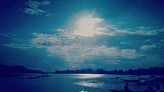
A sunset view
The lake is located within a catchment area covering 316 square kilometres (122sqmi) in the Zabarwan mountain valley, in the foothills of the Shankaracharya Hill, which surrounds it on three sides. The lake, which lies to the east and north of Srinagar city covers an area of 18 square kilometres (6.9sqmi), although including the floating gardens of lotus flowers, it is 21.2 square kilometres (8.2sqmi) (an estimated figure of 22–24 square kilometres (8.5–9.3sqmi) is also mentioned).[5][6][26] The main basin draining the lake is a complex of five interconnected basins with causeways; the Nehru Park basin, the Nishat basin, the Hazratbal basin, the Nigeen basin and the Barari Nambal basin. Navigational channels provide the transportation links to all the five basins.[5][6][26]
The average elevation of the lake is 1,583 metres (5,194ft). The depth of water varies from 6 metres (20ft) at its deepest in Nigeen lake to 2.5 metres (8.2ft), the shallowest at Gagribal. The depth ratio between the maximum and minimum depths varies with the season between 0.29 and 0.25, which is interpreted as flat bed slope.[5][6][27] The length of the lake is 7.44 kilometres (4.62mi) with a width of 3.5 kilometres (2.2mi).[5][6][27] The lake has a basin having shore length of 15.5 kilometres (9.6mi) and roads run all along the periphery. Irreversible changes through urban developments have placed further restrictions on the flow of the lake and as a result, marshy lands have emerged on the peripheral zones, notably in the foothill areas of the Shankaracharya and Zaharbwan hills. These marshy lands have since been reclaimed and converted into large residential complexes.
Geology
Multiple theories explaining the origin of this lake have been formulated. One version is that it is the remnants of a post-glacial lake, which has undergone drastic changes in size over the years and the other theory is that it is of fluvial origin from an old flood spill channel or ox-bows of the Jhelum River.[8][27] The dendritic drainage pattern of the catchment signifies that its rock strata have low levels of porosity. Lithologically, a variety of rock types have been discerned namely, igneous, metamorphic and sedimentary. The Dachigam Telbal Nallah system is conjectured to follow two major lineaments. Discontinuous surfaces seen in the terrain are attributed to the angular and parallel drainage pattern. The water table cuts the hill slopes, which is evidenced by the occurrence of numerous springs in the valley. Seismic activity in the valley is recorded under Zone V of the Seismic Zoning Map of India, the most severe zone where frequent damaging earthquakes of intensity IX could be expected. In the year 2005, Kashmir valley experienced one of the severe earthquakes measured at 7.6 on the Richter's scale, which resulted in deaths and the destruction of many properties, leaving many homeless.[13][28]
Hydrology
Dal
The shallow, open-drainage lake is fed by Dachigam-Telbal Nallah (with perennial flow), Dara Nallah ('Nallah' means "stream") and many other small streams. The lake is classified as 'warm monomictic' under the sub-tropical lake category. Spring sources also contribute to the flow, although no specific data is available to quantify their contribution. To address this, water balance studies to analyse and assess the characteristics of flow have been conducted in order to approximate the discharge contributed by the springs in the lake bed. The complex land use pattern of the valley is reflected in the urbanised Srinagar in its north, with rice fields, orchards and gardens in the lower slopes, and barren hills beyond steep sloping hills. The flat topography also affects drainage conditions. It receives an average annual rainfall of 655 millimetres (25.8in) in the catchment, but during the summer, snow melt from the higher ranges of the catchment results in large inflows into the lake.[5][6][29] The maximum flood discharge of Telbal Nallah has been assessed as 141.5 metres3/s for a one in hundred return period; the 1973 observed flood in Telbal Nallah has been estimated as 113 metres3/s.[30] The average annual flow, according to discharge measurements, has been estimated as 291.9 million cubic metres, with Telbal Nalah accounting for 80% of the total and 20% contributed by other sources. The silt load has been estimated at 80,000 tonnes per year with 70% contribution from the Telabal Nallah, with 36,000 tonnes recorded as settling in the lake.[29]
There are two outlets from the lake, namely the Dalgate and Amir Khan Nallah that connects the lakes of Nigeen and Anchar Lake. Dalgate is controlled by a weir and lock system. The outflow from these two outlets has been estimated as 275.6 million cubic metres.
Flora and fauna
Left: Dal Lake lily pads. Right: Nelumbo nucifera widely grown in the floating gardens of Dal Lake
Since 1934, some important changes have been observed in the lake's biota, including a reduction in the number of Chara species, and an increase in the area covered by Salvinia since 1937. Analysis of the lake has also revealed the tendency for it to develop monospecific communities of submerged macrophytes such as Ceratophyllum and Myriophyllum.
Left: Floating gardens in Dal Lake. Right: Char (Four Chinar Trees) seen on an island in Dal Lake
Floating gardens, labelled the 'Rad' in the Kashmiri language are a special feature of the lake. They basically constitute of matted vegetation and earth, but are floating. These are detached from the bottom of the lake and drawn to a suitable place (generally to the north west of the houseboats' location) and anchored. Given its rich nutrient properties, tomatoes, cucumbers and melons are grown with noteworthy results.[32]
The fishing industry on Dal is the second largest industry in the region and is central to many of the people's livelihoods who reside on the lake's periphery.[35] Dal's commercial fisheries are particularly reliant on carp fish species, which were introduced into the lake in 1957.[citation needed] As a result, carp constitutes 70% of all the fish caught in the lake while the schizothorax constitutes 20% and other species account for 10%. Fishermen use a locally manufactured cast net which comprises six parts with a diameter of 6 metres. It is operated from a wooden fishing boat made out of deodar, typically 20ftx4ft in size. The gradual decline in quality of the lake water through pollution has resulted in lower fish stocks and the extinction of endemic varieties of fish. The causes for such deterioration have been identified and remedial actions have been initiated. The various fishing nets being used in Dal are cast net (Zaal/Duph), Long line (Walruz), Gill net (Pachi, Shaitan zaal), Rod and line (Bislai), Scoop net (Attha zaal) (Bhat et al., 2008).[36]
The lake is warm monomictic (mixing type) and the pH value recorded has varied from a minimum of 7.2 to a maximum of 8.8 on the surface over a yearly period.[5] The Dissolved oxygen [mg l−1] value has varied from a minimum of 1.4 to a maximum of 12.3 on the surface within a year. The Recorded maximum nitrogen concentration (NH4-N [micro l−1] has been recorded as 1315 on the surface and 22 at the bottom of the lake.[5]Phosphorus concentration expressed in Total-P [micro l−1] has varied from a high of 577 to a low of 35 during the 12 months of the year.[5] The lake water temperature has varied from a minimum of 3°C (37°F) in January to 26°C (79°F) in June at the surface. Transparency, expressed as depth in metres, has varied from a maximum of 1.95 metres (6.4ft) in July to a minimum of 0.53 metres (1.7ft) in March, over the 12 months period.[5]
Studies of the water quality of the lake in 1983–84 indicate a decline in quality since the 1965–66 analysis.[5] Scientific research over the years also reveal that Telbal, Botkal, and sewage drains are responsible for a substantial influx of nitrogen and phosphorus into the lake. Quantitatively, fifteen drains and several other sources have released a total of 156.62 tonnes (56.36 tonnes by drains alone) of phosphorus, and 241.18 tonnes of inorganic nitrogen into the lake from a discharge of 11.701 million cubic metres /year.[37] Non-point sources, such as seepage and diffused runoff, also add to this pollution and have been recorded as further adding 4.5 tonnes of total phosphates and 18.14 tonnes of nitrogen (NO3–N and NH4–N) to the lake.[37] Based on the values mentioned above, it has been inferred that the water quality of the lake has deteriorated.
Panoramic view of the Dal
The major environmental problem facing the lake is eutrophication, which has required immediate remedial measures to combat it. Alarmingly, the size of the lake has shrunk from its original area of 22 square kilometres (8.5sqmi) to the present area of 18 square kilometres (6.9sqmi), and there is a concerning rate of sediment deposition due to catchment area degradation.[5] The water quality has also deteriorated due to intense pollution caused by the untreated sewage and solid waste that is fed into the lake from the peripheral areas and from the settlements and houseboats. Besides, some experts like Dr. A.A. Kazmi (Associate Professor, IIT Roorkee and in charge of the Environmental Engineering Lab) believe that deforestation in the catchment of Dal and Telbal stream may have led to more nitrogen and phosphorus-rich run-off, further aiding eutrophication. Encroachments of water channels and consequent clogging has diminished the circulation and inflows into the lake, so with the building up of phosphates and nitrogen, this has led to extensive weed growth and consequences on the biodiversity of the lake.[5][8]
Public interest litigations and restoration works
Identifying the above major issues as causes for the deterioration of the lake, a multidisciplinary team of experts have prepared a Detailed Project Report (DPR), which has the objective of achieving environment and sustainability, ecological improvement with minimum interventions and displacement and balancing the conflicts of interest. This plan is now under implementation with the financial assistance of the Government of India.[5][8]
Dal, Srinagar, July 2012
The serious nature of the environmental problems the lake has been experienced has been widely publicised and has been brought to the attention of the Supreme Court of India. Public Interest Litigations (PILs) have been filed in court demonstrating the environmental dangers posed to the lake by sewage, wastes and effluents. The PILs have sought injunctions of the court for setting up of an integrated ring sewage system encircling the Lake; release of funds by the Government of India to undertake measures to check pollution and to inaugurate a High Powered Committee to monitor proper utilisation of the allotted funds. The committee is under obligation to post feedback of progression developments from time to time, directly to the Supreme Court. The PIL, filed in 2001, has resulted in a number of directives from the court to the funding and implementing agencies and the case is continuing. Consequently, under the National Lake Conservation Plan of the Ministry of Environment and Forests of the Government of India, funds to the extent Rs 2987.6million were sanctioned in September 2005 for the conservation of the lake.[12] The restoration and rehabilitation measures envisaged under the "Conservation and Management of Dal" are under various stages of implementation with the funds allocated by the Government of India for the purpose. Some of the measures undertaken for rehabilitating the lake to bring it to its original eutrophication free status involved measures such as construction of siltation tanks, mechanical weeding, regrouping of houseboats, deepening of outflow channel and removal of bunds and barricades, including some floating gardens.[5] In addition, a moratorium has been imposed on new construction works close to the lakefront, including the building of new house boats. Resettlement plans for migrating the population from the lakefront have also evolved.[5] The long-term development plans also deal with the reafforestation of catchment area to reduce erosion movement and movement of silt and to regulate grazing by livestock. Recent reports indicate that, as of 2010, 40% of the measures have been implemented.[11]
Uses and attractions
Dal lake in 2017
The lake is popular as a visitor attraction and a summer resort. Fisheries and the harvesting of food and fodder plants are also important on Dal.[5] Weeds from the lake are extracted and converted into compost for the gardens. It also serves as a flood lung of the Jhelum River.[32] Swimming, boating, snow skiing (particularly when the lake is frozen during the severe winter), and canoeing are amongst some of the water sports activities practised on the lake.
The lake has numerous sites and places of interest, many of which are important to the cultural heritage of Srinagar. Aside from the Shalimar Bagh and Nishat Bagh, some of the other places frequented by tourists are the Shankaracharya temple, the Hari Parbat, the Nigeen Lake, the Chashme Shahi, the Hazratbal Shrine, and the Mazar-e-Shura cemetery containing the graves of famous Mughal-era poets. Visitors and native alike also enjoy relaxing on the water in a houseboat or a shikara boat, often called "the Gondola of Kashmir".
Left: Nagin Lake. Right: Chasme Shahi under renovation
Nigeen Lake, though sometimes referred to as a separate lake, is actually part of Dal, being linked through a causeway which permits only bikers and walkers to enter the lake precincts. The causeway carries the water supply pipeline to the Srinagar city in the east. The lake is bounded by the Shankaracharya hill (Takht-e-Suleiman) on the south and Hari Parbat on the west and is located at the foot of the Zabarwan hills. Willow and poplar trees flank the edges of the lake.[32][38]
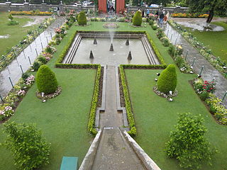
Chashme Shahi, meaning "Royal Spring", is a fresh water spring and garden known for its medicinal properties. Its source located above the Nehru Memorial Park. It is the smallest of all the Mughal gardens in Srinagar, measuring 108 metres (354ft) x 38 metres (125ft) and it has three terraces, an aqueduct, waterfalls and fountains.[38] Ali Mardan Khan built the garden in 1632, and is built in such a way that the spring water is the source of fountains. From the fountains, water flows along the floor of the pavilion and cascades to a lower terrace over a drop of 5 metres (16ft) along a polished black stone chute. A small shrine, known as the Chasma Sahibi, is located in the vicinity of the gardens and has a fresh water spring.[38]
Left: Shankaracharya Temple built in 220 BCE as seen in 1868. Right: Shankaracharya temple as seen now, overlooking Dal Lake
The Shankaracharya Temple is also known as the Jyeshteshwara Temple. It is on top of the Shankaracharya Hill on the Zabarwan Range in Srinagar. It is dedicated to Lord Shiva. The temple is at a height of 1,000 feet (300 m) above the valley floor and overlooks the city of Srinagar.
The temple dates to 220 BCE, although the present structure probably dates to the 9th century CE. It was visited by Adi Shankara and has ever since been associated with him; this is how the temple got the name Shankaracharya. It is also regarded as sacred by Buddhists. Some historians report that the temple was actually a Buddhist temple during the Buddhist era which was then changed into Hindu site of worship by Adi Shankaracharya.
Left: Hari Parbat as seen from Badam Weer (Almond Garden), Srinagar. Right: View of the temple from the stairs
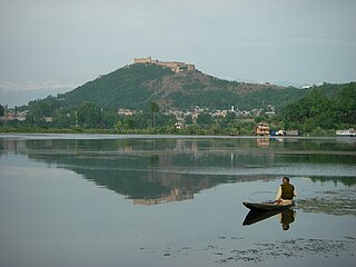
Hari Parbat, also known as the Mughal fort, is a hill fort on Sharika hill that provides panoramic views of the Srinagar city and the Dal. It was first established by MughalEmperor Akbar in 1590. However, he only erected the outer wall of the fort and his plans to build a new capital called Naga Nagor within it did not materialise. The fort in its current state was built much later in 1808 under the reign of Shuja Shah Durrani. Within the fort's precincts are temples, Muslim shrines, and a Sikh Gurudwara. The hill is the subject of many legends in Hindu mythology, and was said to have once been a large sea, inhabited by a demon known as Jalobhava and that the hill grew from a pebble.[38][39]
The Hazratbal Shrine (Urdu: حضرت بل, literally: Majestic Place), also named Hazratbal, Assar-e-Sharief, or simply Dargah Sharif,[40] is a Muslim shrine situated on the left bank of the Dal and is considered to be Kashmir's holiest Muslim shrine.[41] It contains a relic believed by many Kashmiri Muslims to be the Moi-e-Muqqadas, a hair from the head of the Islamic prophetMuhammad. According to legend, the relic was first brought to India by Syed Abdullah, a descendant of Muhammad who left Medina and settled in Bijapur, near Hyderabad in 1635. When Syed Abdullah died, his son, Syed Hamid, inherited the relic. Following the Mughal conquest of the region, Syed Hamid was stripped of his family estates. Finding himself unable to care for the relic, he gave it as the most precious gift to his close Mureed and a wealthy Kashmiri businessman, Khwaja Nur-ud-Din Ishbari.
Mazar-e-Shura (Kashmiri: مزارِ شُعاراء; transliteration: Mazār-i Shuʿārā, translation: The Cemetery of Poets) is a cemetery on a small hill by the main road in Dalgate, an area of Srinagar. Founded in the reign of the Mughul emperor Akbar the Great, it was built in a scenic location on the banks of the Dal as a cemetery for eminent poets. Historical records show that there were at least five poets and men of letters buried in the cemetery: Shah Abu'l-Fatah, Haji Jan Muhammad Qudsi, Abu Talib Kalim Kashani, Muhammad Quli Salim Tehrani, and Tughra-yi Mashhadi, all natives of Iran who emigrated to India and were associated with the Mughal court. Due to neglect, only three tombstones are currently visible, one of which bears an inscription that is only partially legible.
Left: Houseboats, the floating luxury hotels in Dal Lake Right: Houseboats moored to the bank
Houseboats and the Dal are widely associated with Srinagar and are nicknamed "floating palaces", built according to British customs. The houseboats are generally made from local cedar-wood and measure 24–38 metres (79–125ft) in length and 3–6 metres (9.8–19.7ft) in width and are graded in a similar fashion to hotels according to level of comfort. Many of them have lavishly furnished rooms, with verandas and a terrace to serve as a sun-deck or to serve evening cocktails. They are mainly moored along the western periphery of the lake, close to the lakeside boulevard in the vicinity of the Dal gate and on small islands in the lake. They are anchored individually, with interconnecting bridges providing access from one boat to the other. The kitchen-boat is annexed to the main houseboat, which also serves as residence of the boatkeeper and their family.
Left: Shikara on Dal Lake. Right: A florist's shikara boat in Nageen Lake
Each houseboat has an exclusive shikara for ferrying guests to the shore.[42] A shikara is a small paddled taxi boat, often about 15 feet (4.6m) long) and made of wood with a canopy and a spade shaped bottom. It is a cultural symbol of the Kashmir valley, used not only for ferrying visitors but also for the vending of fruits, vegetables and flowers; for fishing and for harvesting aquatic vegetation.[42] All gardens in the lake periphery and houseboats anchored in the lake are approachable through shikaras. The boats are often navigated by one or two boatmen, can seat about six people and have heavily cushioned seats and backrests to provide comfort. The shikara is also used to provide for other sightseeing options in the valley, notably a cruise along the Jhelum River, passing by the famous seven bridges of the city and the backwaters en route.[43]
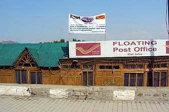
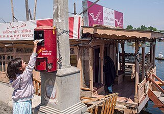
Floating Post Office
The floating post office cum Museum at Dal Lake was inaugurated in 2011 by Omar Abdullah, the then Chief Minister of the state of Jammu and Kashmir.[44][45] It is located on the western edge of Dal Lake.[46][47] It was called Nehru Park post office before 2011. The place will also have a philately museum.[48] Postcards can be bought from Ghat no -1, Budiyar Chowk, and the floating Post Office puts a postage stamp on it.
Floating Post Office - Dal Lake - Srinagar- Jammu and Kashmir
Dal lake is engulfed in three directions by the foreshore and boulevard roads, which stretch along its banks and are dotted with several ghats. Shikaras act as water taxis to navigate within the Dal and can be hired from these ghats.[52] The Dal lies within Srinagar and thus is well connected by road and air links. The nearest airport, which connects with other major cities in the country, is about 12.8 kilometres (8.0mi) away at Badgam. The nearest railway station is Srinagar railway station which is 18.8 kilometres (11.7mi) from Dal Lake. The National Highway NH1A connects the Kashmir valley with rest of the country.
Srinagar ; also known as Shahar or Sernagar in Kashmiri, is a city in Indian-administered Jammu and Kashmir in the disputed Kashmir region. It is the largest city and summer capital of Jammu and Kashmir, which is an Indian-administered union territory. It lies in the Kashmir Valley along the banks of the Jhelum River, and the shores of Dal Lake and Anchar Lakes, between the Hari Parbat and Shankaracharya hills. The city is known for its natural environment, various gardens, waterfronts and houseboats. It is also known for traditional Kashmiri handicrafts like the Kashmir shawl, papier-mâché, wood carving, carpet weaving, and jewel making, as well as for dried fruits. It is the second-largest metropolitan area in the Himalayas.
A houseboat is a boat that has been designed or modified to be used primarily for regular dwelling. Most houseboats are not motorized, as they are usually moored or kept stationary, fixed at a berth, and often tethered to land to provide utilities. However, many are capable of operation under their own power.
Shalimar Bagh (Urdu pronunciation:[ʃɑːliːmɑːɾbɑːɣ], Kashmiri pronunciation:[ʃaːlɨməːrbaːɣ]is a Mughal garden in Srinagar of Indian-administered Jammu and Kashmir,o the northeast of Dal Lake. It is also known as Shalimar Gardens, Farah Baksh, and Faiz Baksh. The other famous shoreline garden in the vicinity is Nishat Bagh, 'The Garden of Delight'. The Bagh was built by Mughal Emperor Jahangir in 1619. The Bagh is considered the high point of Mughal horticulture. It is now a public park and also referred to as the "Crown of Srinagar".
The shikara is a type of wooden boat found on Dal Lake and other water bodies of Srinagar in Jammu and Kashmir. Shikaras are of various sizes and are used for multiple purposes, including transportation. A usual shikara seats six people, with the driver paddling at the rear. Like the Venetian gondolas, they are a cultural symbol of Kashmir. Some shikaras are still used for fishing, harvesting aquatic vegetation, and transport, while most are covered with tarpaulins and are used by tourists. A Shikara ride in Dal Lake is a great way to experience the beauty of Dal Lake and get a glimpse into the life of the locals. Some are used as floating homes.
Bandipore or Bandipora is the headquarters of district of Bandipore in the union territory of Jammu and Kashmir, India. It is located on the northern banks of Wullar Lake—the second-largest freshwater lake in Asia. Also highest Mountain peak of Kashmir Valley Mt Harmukh is in Bandipora.Bandipora has a terraced garden similar to that of Nishat Bagh in Srinagar. Bandipora is bound by mountains on three sides and by Wular Lake on the fourth. As per folklore, the name of Bandipora originated either from Bund of Wular as Bund e pur, from the local folk-singing bands (bāṇd) as Baand e pur or from the enclosed (band) geographical location as Bandh e pur.
Shankaracharya Temple or Jyeshteshwara Temple is a Hindu temple situated on top of the Zabarwan Range in Srinagar in the union territory of Jammu and Kashmir. It is dedicated to Shiva. The temple is at a height of 1,000 feet (300 m) above the valley floor and overlooks the city of Srinagar. The temple is accessible via a road that emerges off Boulevard road near Gagribal.
Hari Parbat, also called Koh-i-Maran, is a hill overlooking Srinagar, the largest city and the capital of Jammu and Kashmir, India. It is the site of the Hari Parbat fort, built by the Durrani Empire, and of a Hindu temple, mosques, and gurdwara.
Chashme Shahi, Chashma i Shahi, or Cheshma Shahi, also called Chashma Shahi or Cheshma Shahi, is one of the Mughal gardens built in 1632 AD around a spring by Ali Mardan Khan, a governor of Mughal emperor Shah Jahan as per the orders of the Emperor, as a gift for his eldest son Prince Dara Shikoh. The garden is located in the Zabarwan Range, near Raj Bhawan overlooking Dal Lake in Srinagar, Jammu and Kashmir, India.
Tota Rani
Nishat Bagh is a terraced Mughal garden built on the eastern side of the Dal Lake, close to Srinagar in the union territory of Jammu and Kashmir, India. It is the second largest Mughal garden in the Kashmir Valley. Nishat Bagh, is also located on the bank of the Dal Lake. 'Nishat Bagh' is Urdu, and means the "Garden of Joy," "Garden of Gladness" and "Garden of Delight."
Jammu and Kashmir is home to several valleys such as the Kashmir Valley, Chenab Valley, Sindh Valley and Lidder Valley. Some major tourist attractions in Jammu and Kashmir are Srinagar, with its renowned Dal Lake and Mughal Gardens, Gulmarg, Pahalgam, Bhaderwah, Patnitop and Jammu. Every year, thousands of Hindu pilgrims visit holy shrines of Vaishno Devi and Amarnath which has had a significant impact on the state's economy.
Manasbal Lake is a freshwater lake located in Safapora area of Ganderbal District in Jammu and Kashmir, India. The name Manasbal is said to be a derivative of Manasarovar. The lake is encircled by four villages viz., Jarokbal, Kondabal, Nesbal and Gratbal. The large growth of lotus at the periphery of the lake adds to the beauty of the clear waters of the lake. The Mughal garden, called the Jaroka Bagh, built by Nur Jahan overlooks the lake.
The Sind River or the Sindh River is a river in the Ganderbal district of the union territory of Jammu and Kashmir, India. It is a major tributary of the Jhelum River and is 108 km long.
Anchar Lake is a lake located in Soura in the Srinagar district of the Indian-administered Jammu and Kashmir.
The Zabarwan Range is a short sub-mountain range between Pir Panjal and Great Himalayan Range in the central part of the Kashmir Valley in the Union Territory of Jammu and Kashmir in India.
Foreshore Road is one of the prestigious roads in the city of Srinagar. The notability of the road lies in the fact that the entire road lies on the banks of Dal Lake. The road starts from Hazratbal, Srinagar and ends at Nishat. The famous Mughal Gardens of Shalimar Bagh and Nishat Bagh are situated on the road. The economy of the people living here greatly depends on tourism. The road is also connected to the Boulevard road. Driving on the road provides glances of the beautiful Dal Lake and views of the sunset can be enjoyed from this road. In the summers the cool breeze of Dal Lake provides respite to the people resting on the roadside. From 13 April every year, government officials open the Mughal Gardens for visitors around the world. Due to this, tourists can be seen on the way to visit these places. The Foreshore and Boulevard roads also host largest number of hotels for tourists in Srinagar and is maintained by the Government of Jammu and Kashmir regularly.
Lal Bazar is a locality in the municipal committee of Srinagar in the Indian administered union territory of Jammu and Kashmir. It comes under the Zadibal constituency of the Srinagar Legislative Assembly. Lal Bazar is a well known posh area in the upper downtown area of Srinagar. The Pincode of Lal Bazar is 190023. Considered amongst the best residential areas in Srinagar the area has many amenities such as major banks and schools along with University of Kashmir,NIT Srinagar, Institute of Technology, University of Kashmir, Zakura Campus, Sher - i - Kashmir Institute of Medical Sciences close by, roughly 2 km from Lal Bazar.
Nigeen Lake is a lake located in Srinagar, Jammu and Kashmir, India. It is mildly eutrophic, a term that refers to a body of water rich in nutrients, which cause excessive growth of aquatic plants like algae, resulting in bacteria that consume nearly all the oxygen. It is sometimes considered a part of Dal Lake and is connected to it via a narrow strait. It is also connected to the Khushal Sar and Gil Sar lakes via a channel known as Nallah Amir Khan.
The Marsar Lake is an oligotrophic alpine lake located in Aru valley of Pulwama district in Jammu and Kashmir, India. It is close to the Aru valley in Pahalgam. The lake is separated by a mountain with a minimum peak elevation of 4,000 metres (13,000 ft) from another lake of the same nature known as Tarsar Lake. Due to their close proximity and similar physical characteristics, the two lakes are often called as the "twin sisters". The site has over the years become a famous tourist destination. Tarsar-Marsar Trek is one of the highly opted treks of the Kashmir Valley. A stream emerges from this lake, which travels through the Dachigam valley and enters Srinagar near Harwan garden where it fills the Sarband reservoir. This stream is joined by another stream which flows from Mount Mahadeo near the Telbal village and from thereon it is called the Telbal nallah which is the primary source of the Dal Lake.
Naseem Bagh is a Mughal garden built on the northwestern side of the Dal Lake, close to the city of Srinagar in Jammu and Kashmir, India.
↑ "Dal Lake". National Informatics Centre. Archived from the original on 25 July 2009. Retrieved 3 April 2010. The world famous water body has been described as Lake Par-Excellence by Sir Walter Lawrence. It is the Jewel in the crown of the Kashmir and is eulogised by poets and praised abundantly by the tourists.
↑ Singh, Sarina (2005). India. Lonely Planet. p.344. ISBN978-1-74059-694-7. Retrieved 3 April 2010. peaceful Dal Lake is Srinagar's Jewel
1 2 Bindloss, Joe; Sarina Singh (2007). India. Lonely Planet. pp.353–354, 360. ISBN978-1-74104-308-2. Retrieved 29 December 2009. it is a very beautiful lake.{{cite book}}: |work= ignored (help)
1 2 Singh, Bhupinder. Land of the Seventh River: Travels in Rajasthan and Kashmir. Rupa Publications, 2007, pp. 126-127.
↑ Khosa, Ashok K. Dal Lake: Lotus Land of Kashmir. Gulshan Publishers, 2002, p. 15.
↑ The Alternate Hydro Energy <SOUMYA AND AKHIL> centre of the University of Rookee. "Geological Aspects". House Boat Owners Association. Archived from the original on 25 March 2012. Retrieved 27 December 2009.
↑ The Alternate Hydro Energy centre of the University of Rookee. "Hydrology and water Balance Studies". House Boat Owners Association. Archived from the original on 25 March 2012. Retrieved 27 December 2009.
1 2 The Alternate Hydro Energy centre of the University of Rookee. "Data Collection and Analysis". House Boat Owners Association. Archived from the original on 25 March 2012. Retrieved 27 December 2009.
↑ "Pilgrimate Tours". House Boats, Kashmir. Archived from the original on 6 February 2010. Retrieved 3 April 2010. The shrine is situated on the left bank of the Dal Lake, Srinagar and is considered to be Kashmir's holiest Muslim shrine
This page is based on this Wikipedia article Text is available under the CC BY-SA 4.0 license; additional terms may apply. Images, videos and audio are available under their respective licenses.