Doda district

Last updated

Doda district
District of Jammu and Kashmir administered by India [1]
View of Doda city in Jammu.jpg
View of Doda city
Doda district
Interactive map of Doda district
Kashmir region. LOC 2003626427 - showing Jammu division administered by India in neon blue.jpg
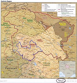
Doda district is in the eastern part of the Jammu division (shown with neon blue boundary) of Indian-administered Jammu and Kashmir (shaded in tan in the disputed Kashmir region [1]
Coordinates(Doda): 33°08′N75°34′E / 33.13°N 75.57°E / 33.13; 75.57
Administering countryIndia
Union Territory Jammu and Kashmir
Division Jammu
Region Chenab Valley
Headquarters Doda
Government
   District Magistrate Harvinder Singh (IAS) [2]
  Additional Deputy CommissionerDr. Ravi Kumar Bharti (JKAS) [3]
  Assistant Commissioner RevenueSanjeev Kumar (JKAS) [3]
Area
[4]
  Total2,625 km2 (1,014 sq mi)
  Urban
19.75 km2 (7.63 sq mi)
  Rural
2,605.25 km2 (1,005.89 sq mi)
Population
 (2011) [5]
  Total409,936
  Density160/km2 (400/sq mi)
   Urban
32,689
   Rural
377,247
Demographics
   Literacy 64.68%
  Sex ratio919
Time zone UTC+05:30 (IST)
Vehicle registration JK-06
Major highways NH 244
Website doda.nic.in

Doda district is an administrative district of the Jammu division of Indian-administered Jammu and Kashmir in the disputed Kashmir region. [1]

Contents

Administration

The district consists of 18 tehsils: Thathri, Bhaderwah, Doda, Mohalla, Bhagwa, Assar, Bhalla, Gundna, Marmat, Kahara, Gandoh (Bhalessa), Bhella, Bharat Bagla, Chiralla, Chilly Pingal, Phagsoo and Kastigarh. [6]

Climate

The climate of the area is not uniform due to its wide variations in altitude. The area, in general, enjoys a temperate to sub-tropical climate. The climate of the district is almost dry and rainfall is scanty. The temperature varies from place to place. Ramban and Doda tehsils are warmer, while regions like Dessa Valley, tehsil Bhagwah, Gundna, Padder, Marwah and Warwan remain snow-bound for five-six months of the year. Summer is generally without precipitation. Almost all regions experiences snowfall in the winter, either in the form of snowfall in higher regions or as rainfall in the lower regions. Monsoons prevail from July to September. Rainfall in the Doda district is heavy during July and September. The average annual rainfall is 926 mm and snowfall of about 135 mm. [7]

History

Kailash Kund lake, Doda district Kailash kund bhaderwah.jpg
Kailash Kund lake, Doda district

The demography of Doda district is complex compared to neighbouring districts, because of its very diverse population. In the past, Doda was largely inhabited by a Sarazi population before people started settling here from Kashmir and other adjoining areas. [8] [9] It got the name Doda due to the opium plant, known as doddi in the local language. Kashmiri populations settled here in the 17th and 18th centuries. [10] Sumantra Bose says repression by feudal classes elsewhere drew people to the districts of Doda, Ramban and Kishtwar. [11] [12]

The Doda district consists of areas drawn from the ancient principalities of Kishtwar and Bhadarwah, both of which became part of a district by the name of 'Udhampur' in the princely state of Jammu and Kashmir. [13]

The district of Doda in Jammu and Kashmir has a long history intertwined with legends and stories of various rulers and dynasties. According to records from the State Revenue Department, the district got its name from its headquarters in Doda, which was named after a migrant from Multan, a utensil maker. He was persuaded by one of the ancient rulers of Kishtwar to settle in the area and establish a utensil factory. Over time, the name Deeda was distorted into Doda. [14]

The early history of Doda is not well documented, with few chronicles available about the rulers of Kishtwar. The settlement reports indicate that the area was ruled by various groups including Ranas, Rajas, and independent chiefs from time to time, including the Jaral, Ranas, Katoch Rajas, Bhaus Manhases, Chibs, Thakkars, Wanis, and Gakkars. In 1822 AD, Doda was conquered by Maharaja Gulab Singh and became the winter capital of the Kishtwar state. [15]

The Fort of Doda was significant in the district's history and was one of the seventy forts in Jammu province, according to author Thakur Kahan Singh Balowria. The fort served as the office of the Thanedar and provided storage space for armaments and food grains. The fort was also built to protect against potential attacks from the Bhaderwah Rajas. The fort was made of unbaked bricks and had walls that were four feet wide and forty to fifty feet high, with dome-like towers at the corners. The fort was demolished in 1952 and as of 2023, the Government Boys Higher Secondary School occupies its site. [16]

English traveller G.T. Vigne visited Doda in 1829 and described his journey through the district. He mentions traveling through a deep and rocky nullah which joins the Chenab River, [lower-alpha 1] and then crossing the river over a dangerous bridge in the Himalayas. Vigne writes about the bridge in Doda, a strong rope stretched from one bank to the other, tied to rocks. A wooden structure was placed over the rope and additional ropes were tied to it, allowing the structure to move back and forth. He also encountered another type of bridge, which was crossed on foot, made of small ropes bound with pieces of bark and woven into a thick rope. Hanging ropes were provided for support. [14] [16]

The area that includes the tehsil of Bhaderwah has a long history dating back to the 10th century. In 1846, Doda and Kishtwar became part of the newly created Jammu and Kashmir state after the Amritsar pact between the British government, Lahore Darbar, and Raja Gulab Singh of Jammu. Bhaderwah was once a principality with 15 administrative units and has a recorded history going back to the Rajtarangni of Kalhan. The state of Bhadhrwah was established in the 15th century by a Sicon of the Baloria family of Bilawar. It was later ruled by the Raja of Chamb until Raja Nagpal became the ruler in the 16th century. Bhaderwah was then ruled by Nagpal's descendants until it was captured by the Kishtwar Raja. It became part of Chamba in 1821 and was transferred to Jammu Darbar in 1846. During this time, Bhaderwah was military-administered Label was appointed as the Kardar. The Bhaderwah Jagir was later bestowed upon Raja Amar Singh of Jammu and then to his son, Raja Hari Singh. When Raja Hari Singh became the Maharaja of J&K in 1925, he dissolved his Jagirs and converted Bhaderwah into a tehsil of Udhampur in 1931. [17]

In 1948, the erstwhile Udhampur district was partitioned into the present Udhampur district, containing the Udhampur and Ramanagar tehsils, and 'Doda' district containing the Ramban, Bhadarwah, Thathri and Kishtwar tehsils. [18] [11] [19]

In 2006, Ramban was made into an independent district and the hilly area to the east of the present Doda district was separated as the Kishtwar district. The remaining areas include the Doda tehsil carved out of Kishtwar and the original Bhadarwah, now divided into three tehsils. [18] [20]

In 1990s, various incidents were reported about the suppression of Hindus by the Militant organizations. In response to the rising terrorism, the government authorities made Village Defense Committee (VDC) in various villages. However some reports of VDC members indulging in criminal activities have also reported in the past. In a village called Karada, four Muslims were allegedly killed by VDC members. This incident also triggered the Terrorist organisations to target those who supported the VDCs, believing them to be anti-Muslim. Since 1990s, many such incidents of killings by Terrorist and VDCs have been reported. [21]

In June 2023, an earthquake of 5.4 magnitude jolts Doda district.

Demographics

Historical population
YearPop.±%
1901 102,011    
1911 112,009+9.8%
1921 117,759+5.1%
1931 127,477+8.3%
1941 140,446+10.2%
1951 147,489+5.0%
1961 154,532+4.8%
1971 170,787+10.5%
1981 224,197+31.3%
1991 290,727+29.7%
2001 372,613+28.2%
2011 476,835+28.0%
† 1951 and 1991 populations are estimated
Source: Census of India [22]
Religion in Doda district (2011) [5]
ReligionPercent
Islam
53.82%
Hinduism
45.77%
Other or not stated
0.41%

Languages of Doda district (2011) [23]

   Kashmiri (41.59%)
   Bhadarwahi (20.00%)
   Siraji (13.84%)
   Gojri (7.53%)
   Hindi (5.20%)
   Dogri (3.96%)
   Pahadi (2.43%)
   Haryanvi (1.55%)
  Others (3.90%)

According to the 2011 census, Doda district has a population of 409,936, [24] roughly equal to the nation of Malta. [25] This gives it a ranking of 556th in India (out of a total of 640). [24] The district has a population density of 79 inhabitants per square kilometre (200/sq mi). [24] Its population growth rate over the decade 2001–2011 was 27.89%. [24]

Doda has a sex ratio of 922 females for every 1000 males [24] (this varies with religion), and a literacy rate of 65.97%. [24]

Religion

The district has a Muslim majority 53.82%, with Hindus constituting 45.77% of the population and the remainder consisting of Christians, Sikhs, Buddhists and Jains. [26]

Doda's society is a mixture of all religions with Hindus and Muslims being two major communities. The population ratio between the Muslims and the Hindus as per the census report of 2011 is around 55:45. Muslims of the region are mostly ethnic Kashmiris and are culturally and linguistically connected to the people of Kashmir. [11] [10] [27]

Doda district: religion, gender ratio, and % urban of population, according to the 2011 Census. [5]
HinduMuslimChristianSikhBuddhistJainOtherNot statedTotal
Total187,621220,614472422212242722409,936
45.77%53.82%0.12%0.10%0.01%0.01%0.01%0.18%100.00%
Male98,252114,37232428691124363213,641
Female89,369106,242148136121118359196,295
Gender ratio (% female)47.6%48.2%31.4%32.2%57.1%50.0%42.9%49.7%47.9%
Sex ratio
(no. of females per 1,000 males)
910929989919
Urban9,78622,6684015301402832,689
Rural177,835197,94643226921842694377,247
 % Urban5.2%10.3%8.5%36.3%0.0%63.6%0.0%3.9%8.0%
Sex Ratio in Doda District in 2011 Census. [5]
(no. females per 1,000 males)
Religion (and population)Sex Ratio
Muslim (pop 220,614)
929
Hindu (pop 187,621)
910
Other (pop 1,701)
673
Total (pop 409,936)
919

Languages

Prominent Scholar Sumantra Bose states that the plurality of population of Doda speaks Kashmiri as their mother language. [28] [29] A study conducted in 2014 identified 40% of the population as Kashmiri-speaking. [30] The Pahadi languages are spoken by the second largest group: Bhadarwahi and Sarazi are the main ones. [31] Others in the district speak Gojri and Dogri.

Doda's population comprises different communities who live together peacefully despite following different religions and speak different languages. Most of the people of the region are well-versed with all the languages spoken in the area. [32] [9]

Administration

Administratively, the district has 406 villages. Doda District has been divided into three subdivisions viz., Doda, Thathri, Bhaderwah and Bhalessa (Gandoh). It has eighteen tehsils. [33]

Villages

Politics

Doda district has three assembly constituencies: Bhaderwah, Doda and Doda West. [34] [35]

Terrorism

Doda had a history of terrorism, with one of the highest concentration of militants in Jammu and Kashmir. According to local authorities, about 200 militants were active in the district in the early 2000s. [36]

Militants targeted the Hindu and Muslim villagers. Some anti-social outfits mostly misused the VDCs. A report said that the 489 civilians had been killed in the region as of 2005. [37]

There have been a number of killings of innocent civilians by militants and anti-social outfits including:


Related Research Articles

<span class="mw-page-title-main">Baramulla district</span> District in Jammu and kashmir, India

Baramulla district or Varmul is one of the 20 districts in the Indian-administered union territory of Jammu and Kashmir in the disputed Kashmir region. Baramulla town is the administrative headquarters of this district. The district covered an area of 4,588 km2 (1,771 sq mi) in 2001, but it was reduced to 4,243 km2 (1,638 sq mi) at the time of 2011 census. In 2016, the district administration said that the area was 4,190 km2 (1,620 sq mi). Muslims constitute about 98% of the population.

<span class="mw-page-title-main">Bhaderwah</span> Town and Tourist destination in Jammu and Kashmir

'Bhaderkashi or Bhadarwah is a town, tehsil, and sub-district in the Doda district of Jammu Division of Jammu and Kashmir, India. It is also known as Mini Kashmir for it's scenic beauty. The ancient name of Bhaderwah is Bhadravakasa as mentioned in Kalhana's Rajatarangini. For its high literacy rate it is known as Kerala of Jammu and Kashmir.

<span class="mw-page-title-main">Kishtwar</span> Town and district headquarters in Jammu and Kashmir

Kishtwar is a town, municipality and administrative headquarter of the Kishtwar district in the Indian-administered Jammu and Kashmir. The district was carved out of the Doda district in 2007. and is located in the Jammu division. The town of Kishtwar is situated at a distance of 211.5 km (131.4 mi) from the winter capital of Jammu. A large ground locally called as Chowgan ground is located in the heart of the town.

<span class="mw-page-title-main">Reasi district</span> District of Jammu and Kashmir administered by India

Reasi district is an administrative district in the Jammu division of Indian-administered Jammu and Kashmir in the disputed Kashmir region. The Reasi district is bordered by Udhampur district and Ramban district in the east, Jammu district in the south, Rajouri district in the west and by Kulgam district on the north. The Reasi and Rajouri tehsils formed a joint district called the "Reasi district" at the time of the princely state's accession to India in 1947. As part of the reorganisation, the two tehsils were separated and Reasi was merged with the Udhampur district. It again became a separate district in 2006.

<span class="mw-page-title-main">Ramban district</span> District of Jammu and Kashmir administered by India

Ramban district is an administrative district in the Jammu division of Indian-administered Jammu and Kashmir in the disputed Kashmir region. It is located in a valley surrounded the Pir Panjal range. It was carved out as a separate district from erstwhile Doda district in 2007. It is located in the Jammu division. The district headquarters are at Ramban town, which is located midway between Jammu and Srinagar along the Chenab river in the Chenab valley on National Highway-44, approximately 151 km from Jammu and Srinagar.

<span class="mw-page-title-main">Kishtwar district</span> District of Jammu and Kashmir, India

Kishtwar district is an administrative district of the Jammu division of Indian-administered Jammu and Kashmir in the Jammu Division. As of 2011, it is the largest and the least populous district of Jammu and Kashmir.

<span class="mw-page-title-main">Paddar</span> Sub-division in Jammu & Kashmir, India

Paddar, also spelled Padar, is a Sub-District and remote valley in the Kishtwar district of the union territory of Jammu and Kashmir, India. It falls in the Jammu division. It consists of two tehsils namely Machail and Atholi Paddar The valley covers the entire southeastern portion of the Kishtwar district. It borders Zanskar (Ladakh) in the north and east, Pangi in the south and the rest of Jammu and Kashmir in the west. The valley is known for its Sapphire mines. Albeit Sapphires are located in the valley of Paddar in Jammu division, they are known as Kashmiri sapphires which is a misnomer. It lies along the Chandrabhaga river (Chenab) in the Great Himalayas. Paddar is one of the most remote regions of Jammu and Kashmir. There are a number of small valleys within Paddar, such as Machail, Gandhari, Kabban, Ongai, Bhuzunu, Barnaj, Bhuzas, Kijai Nallah, and Dharlang, among others.

<span class="mw-page-title-main">Chenab Valley</span> Valley and proposed administrative division in Jammu and Kashmir, India

The Chenab Valley is a river valley formed by the Chenab River. The term is also used collectively for Doda, Kishtwar and Ramban districts of Jammu Division in the Indian-administered Jammu and Kashmir. These districts were formerly part of a single district, called Doda.

<span class="mw-page-title-main">Jammu division</span> Administrative division in Jammu and Kashmir, India

The Jammu division is a revenue and administrative division of the Indian-administered Jammu and Kashmir in the disputed Kashmir region. It is bordered by the Kashmir division to the north. It consists of the districts of Jammu, Doda, Kathua, Ramban, Reasi, Kishtwar, Poonch, Rajouri, Udhampur and Samba. Most of the land is hilly or mountainous, including the Pir Panjal Range which separates it from the Kashmir Valley and part of the Great Himalayas in the eastern districts of Doda and Kishtwar. Its principal river is the Chenab.

<span class="mw-page-title-main">Thathri</span> A town and a tehsil in Jammu and Kashmir

Thathri is a town and a notified area committee in Doda district in the Indian union territory of Jammu and Kashmir. Thathri valley is located in the foothills of the Himalayan mountains, about 85 km from Batote. Apart from having ample forests, the town contains many small streams flowing through its various parts. It is located on the banks of the Chenab River and the town area is spread over 1.50 sq. Km².

<span class="mw-page-title-main">Warwan Valley</span> Valley in Jammu and Kashmir, India

The Warwan Valley is a Himalayan sub-valley and a tehsil in Kishtwar District in the Jammu division in union territory of Jammu and Kashmir in India. The Valley lies 68 kilometres (42 mi) northeast of Kishtwar and 150 kilometres (93 mi) from Srinagar, the summer capital of Jammu and Kashmir.

<span class="mw-page-title-main">Sarazi language</span> Language spoken in the Saraz region of Jammu, India

Sarazi or Sirazi is an Indo-Aryan language spoken in the Saraz region of the Jammu division of Jammu and Kashmir, India. It is native to the Saraz region, a hilly area taking up the northern half of Doda district and parts of neighbouring Ramban and Kishtwar districts. Sarazi is spoken as a first language by 46,000 people, primarily Hindus, but it is also used as a lingua franca of the Saraz region and so is also spoken as a second language by Muslims, whom are native speakers of Kashmiri.

Ababeel (ابابیل), also known as Ababeel NGO, is a charitable trust that provides emergency assistance, disaster relief, food kits, and blood donations for the needy, poor, orphans, widows, and also in emergencies in the Chenab Valley's Doda, Kishtwar, Thathri, Bhaderwah, Gandoh, and also in the Jammu area. The organization assists people irrespective of caste and religion. It is registered with the Sub Registrar Court Doda.

<span class="mw-page-title-main">Village Defence Guards</span> Armed villagers groups in Jammu and Kashmir

Village Defence Guards (VDGs) formerly known as Village Defence Committees is a civilian militia first established in the mid-1990s in the Chenab Valley area of Indian-administered territory of Jammu and Kashmir for the self-defence of locals, especially Hindus, in remote hilly villages against militancy. It consist of villagers as well as police officers. The VDGs have been accused of numerous human rights violations including dozens of cases of murder and rape.

Saraz or Siraj is a hilly region in the eastern part of the Jammu division of Jammu and Kashmir in northern India. Historically a pargana within the erstwhile state of Kishtwar, the region currently takes up the northern half of Doda district and parts of neighbouring Ramban and Kishtwar districts. Its population in 2011 stood at 180,000 people. The region is defined mainly on the basis of linguistics where the majority of people speak Sarazi as their mother tongue.

<span class="mw-page-title-main">Bhalessa</span> Region in Jammu and Kashmir, India

Bhalessa is a geographical area within Doda district in the Jammu region of India-administered Kashmir. It consists of the Bunjwah and Bhalessa Valleys, and comprises the three Tehsils of Kahara, Chilly Pingal and Gandoh.

1993 Kishtwar massacre was the killing of 16–17 Hindu bus passengers by Muslim militants in the Sarthal area of Kishtwar district of the erstwhile state of Jammu and Kashmir in India on 14 August 1993. The massacre was the first of several communally motivated attacks and mass murders of Hindu civilians by militants during the insurgency in the territory. The massacre marked beginnings of the spread of insurgent violence to Jammu region and triggered a migration of some Hindus out of the erstwhile Muslim-majority Doda district.

Halaran is a village and panchayat located in the Kahara tehsil of Doda district in the Indian administered union territory of Jammu and Kashmir. The village is situated approximately 13 kilometers away from the sub-divisional headquarters, Thathri, and 43 kilometers away from the district headquarters, Doda.

References

  1. 1 2 3 The application of the term "administered" to the various regions of Kashmir and a mention of the Kashmir dispute is supported by the tertiary sources (a) through (d), reflecting due weight in the coverage. Although "controlled" and "held" are also applied neutrally to the names of the disputants or to the regions administered by them, as evidenced in sources (f) through (h) below, "held" is also considered politicized usage, as is the term "occupied," (see (i) below).
    (a) Kashmir, region Indian subcontinent, Encyclopaedia Britannica, retrieved 15 August 2019 (subscription required) Quote: "Kashmir, region of the northwestern Indian subcontinent ... has been the subject of dispute between India and Pakistan since the partition of the Indian subcontinent in 1947. The northern and western portions are administered by Pakistan and comprise three areas: Azad Kashmir, Gilgit, and Baltistan, the last two being part of a territory called the Northern Areas. Administered by India are the southern and southeastern portions, which constitute the state of Jammu and Kashmir but are slated to be split into two union territories.";
    (b) Pletcher, Kenneth, Aksai Chin, Plateau Region, Asia, Encyclopaedia Britannica, retrieved 16 August 2019 (subscription required) Quote: "Aksai Chin, Chinese (Pinyin) Aksayqin, portion of the Kashmir region, at the northernmost extent of the Indian subcontinent in south-central Asia. It constitutes nearly all the territory of the Chinese-administered sector of Kashmir that is claimed by India to be part of the Ladakh area of Jammu and Kashmir state.";
    (c) "Kashmir", Encyclopedia Americana, Scholastic Library Publishing, 2006, p. 328, ISBN   978-0-7172-0139-6 C. E Bosworth, University of Manchester Quote: "KASHMIR, kash'mer, the northernmost region of the Indian subcontinent, administered partlv by India, partly by Pakistan, and partly by China. The region has been the subject of a bitter dispute between India and Pakistan since they became independent in 1947";
    (d) Osmańczyk, Edmund Jan (2003), Encyclopedia of the United Nations and International Agreements: G to M, Taylor & Francis, pp. 1191–, ISBN   978-0-415-93922-5 Quote: "Jammu and Kashmir: Territory in northwestern India, subject to a dispute betw een India and Pakistan. It has borders with Pakistan and China."
    (e) Talbot, Ian (2016), A History of Modern South Asia: Politics, States, Diasporas, Yale University Press, pp. 28–29, ISBN   978-0-300-19694-8 Quote: "We move from a disputed international border to a dotted line on the map that represents a military border not recognized in international law. The line of control separates the Indian and Pakistani administered areas of the former Princely State of Jammu and Kashmir.";
    (f) Kashmir, region Indian subcontinent, Encyclopaedia Britannica, retrieved 15 August 2019 (subscription required) Quote: "... China became active in the eastern area of Kashmir in the 1950s and has controlled the northeastern part of Ladakh (the easternmost portion of the region) since 1962.";
    (g) Bose, Sumantra (2009), Kashmir: Roots of Conflict, Paths to Peace, Harvard University Press, pp. 294, 291, 293, ISBN   978-0-674-02855-5 Quote: "J&K: Jammu and Kashmir. The former princely state that is the subject of the Kashmir dispute. Besides IJK (Indian-controlled Jammu and Kashmir. The larger and more populous part of the former princely state. It has a population of slightly over 10 million, and comprises three regions: Kashmir Valley, Jammu, and Ladakh.) and AJK ('Azad" (Free) Jammu and Kashmir. The more populous part of Pakistani-controlled J&K, with a population of approximately 2.5 million. AJK has six districts: Muzaffarabad, Mirpur, Bagh, Kodi, Rawalakot, and Poonch. Its capital is the town of Muzaffarabad. AJK has its own institutions, but its political life is heavily controlled by Pakistani authorities, especially the military), it includes the sparsely populated "Northern Areas" of Gilgit and Baltistan, remote mountainous regions which are directly administered, unlike AJK, by the Pakistani central authorities, and some high-altitude uninhabitable tracts under Chinese control."
    (h) Fisher, Michael H. (2018), An Environmental History of India: From Earliest Times to the Twenty-First Century, Cambridge University Press, p. 166, ISBN   978-1-107-11162-2 Quote: "Kashmir’s identity remains hotly disputed with a UN-supervised “Line of Control” still separating Pakistani-held Azad (“Free”) Kashmir from Indian-held Kashmir.";
    (i) Snedden, Christopher (2015), Understanding Kashmir and Kashmiris, Oxford University Press, p. 10, ISBN   978-1-84904-621-3 Quote:"Some politicised terms also are used to describe parts of J&K. These terms include the words 'occupied' and 'held'."
  2. "Deputy commissioner of Doda - Official Website".
  3. 1 2 "Who's Who in Doda district" . Retrieved 13 September 2021.
  4. District Census Handbook Doda, Part B (PDF). Census of India 2011 (Report). 18 June 2014. pp. 9, 12, 99. Retrieved 21 November 2020.
  5. 1 2 3 4 C-1 Population By Religious Community – Jammu & Kashmir (Report). Office of the Registrar General & Census Commissioner, India. Retrieved 28 July 2020.
  6. "Statement showing the number of blocks in respect of 22 Districts of Jammu and Kashmir State including newly Created Districts" (PDF). Jammu and Kashmir Revenue Department. Government of Jammu and Kashmir. Archived from the original (PDF) on 10 September 2008.
  7. "Doda, Jammu and Kashmir, IN Climate Zone, Monthly Averages, Historical Weather Data". Global Historical Weather and Climate Data. 1 April 2018. Retrieved 22 September 2023.
  8. "Sarazi: Endangered Language of the Chenab Valley".
  9. 1 2 "Story of Doda misunderstood by Kashmir". Greater Kashmir. 13 March 2015. Retrieved 6 September 2019.
  10. 1 2 "Mini Kashmir". Kashmir Life. 11 January 2011. Retrieved 6 September 2019.
  11. 1 2 3 Snedden, Christopher (2015), Understanding Kashmir and Kashmiris, Oxford University Press, p. xxi, 23, ISBN   978-1-84904-342-7
  12. "Sarazi: Endangered Language of the Chenab Valley". Sahapedia. Retrieved 6 September 2019.
  13. "About Doda District". Jammu Redefining. Archived from the original on 17 March 2016.
  14. 1 2 CT, News Desk (1 February 2023). "The lost history of Doda". The Chenab Times . Doda, Jammu and Kashmir. Retrieved 2 February 2023.
  15. "History | District Doda | India". National Informatics Centre . Doda Administration. Retrieved 2 February 2023.
  16. 1 2 "Doda: Brief History, Places of Attraction". The Dispatch. 19 April 2019. Archived from the original on 2 February 2023. Retrieved 2 February 2023.
  17. Maini, K D (6 February 2016). "Past, present of Doda". Daily Excelsior . Retrieved 2 February 2023.
  18. 1 2 "District profile". Krishi Vigyan Kendra, Doda. Archived from the original on 9 October 2016. Retrieved 23 October 2016.
  19. Behera, Navnita Chadha (2007), Demystifying Kashmir, Pearson Education India, p. 28, ISBN   978-8131708460
  20. "8 New Districts in JK, 13 New Tehsils". Greater Kashmir. 7 July 2006.
  21. 1 2 Joshi, Rajesh (17 August 1998). "Slow Death in Doda". Outlook. Retrieved 20 June 2020.
  22. "A-2 Decadal Variation In Population Since 1901". Censusindia.gov.in. Retrieved 9 August 2019.
  23. C-16 Population By Mother Tongue – Jammu & Kashmir (Report). Office of the Registrar General & Census Commissioner, India. Retrieved 18 July 2020.
  24. 1 2 3 4 5 6 "District Census 2011". Census2011.co.in. 2011. Retrieved 30 September 2011.
  25. US Directorate of Intelligence. "Country Comparison:Population". Archived from the original on 13 June 2007. Retrieved 1 October 2011. Malta 408,333 July 2011 est.
  26. "District Census Handbook: Doda" (PDF). Directorate of Census Operations, Jammu & Kashmir, 2017.
  27. "Untitled Document". fathom.lse.ac.uk. Archived from the original on 15 July 2020. Retrieved 6 September 2019.
  28. Bose, Sumantra (10 September 2010). "Geography, Politics and the Fighters of Kashmir". London School of Economics. Archived from the original on 16 December 2011.
  29. "Kashmir: Roots of Conflict, Paths to Peace". Foreign Affairs. 28 January 2009. ISSN   0015-7120 . Retrieved 6 September 2019.
  30. Bukhari, Shujaat (29 June 2014). "Nearly 35% People Speak Kashmiri In Erstwhile J&K: Study". Rising Kashmir.
  31. "Saraz and Sarazi: Situating a Language and Linguistic Zone in Jammu and Kashmir".
  32. "Saraz and Sarazi: Situating a Language and Linguistic Zone in Jammu and Kashmir". Sahapedia. Retrieved 6 September 2019.
  33. Creation of new Administrative Units in the State (PDF). Government of Jammu and Kashmir. 16 July 2014.
  34. "Jammu gets 6 new assembly constituencies, 12 segments reserved for STS, SCS". 5 May 2022.
  35. "ERO's and AERO's". Chief Electoral Officer, Jammu and Kashmir. Archived from the original on 22 October 2008. Retrieved 28 August 2008.
  36. Hussain, Aijaz (15 May 2006). "The Doda Deathtrap". India Today . Retrieved 25 February 2017.
  37. "India: Kashmir massacre sparks ethnic cleansing fears". ReliefWeb, United Nations Office for the Coordination of Humanitarian Affairs (OCHA). 6 May 2006. Retrieved 20 June 2020.
  38. Pillai, Ajith; Meraj, Zafar (29 June 1998). "Slaughter Of The Innocents". Outlook India .
  39. "Chronology for Kashmiris in India". 25 October 1998. Retrieved 21 June 2020.
  40. "Ultras massacre 17 in Doda". The Tribune. 5 August 2001.
  41. "Militants massacre 15 Hindu villagers in Doda". Rediff. 4 August 2001.
  42. Sengupta, Somini (2 May 2006). "Militants Kill 35 Hindus Days Before Talks on Kashmir". New York Times.
  43. "Voices of Doda". The Times of India . Retrieved 20 June 2020.
  44. Hussain, Aijaz (15 May 2006). "19 villagers massacred in Kashmir Valley, act suspected to polarise two communities". India Today.
  45. "Cow vigilantes kill lone breadwinner of family in J&K". 18 May 2019. Retrieved 20 June 2020.
  46. Naseem, Ishfaq (16 May 2019). "Nayeem Ahmad Shah, who was killed by cow vigilantes in Jammu's Bhaderwah, was carrying no animal during attack, claims relative" . Retrieved 20 June 2020.
  47. "J&K: Five-member SIT constituted to probe killing of a man by alleged cow vigilantes in Bhaderwah" . Retrieved 21 June 2020.

Further reading

Notes

  1. The Nullah traversed by Vigne is most likely the Neeru river, which joins the Chenab at Pul Doda.