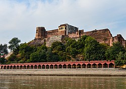
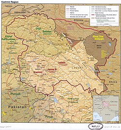
Jammu[a] and Kashmir[b] (abbr.J&K) is a region administered by India as a union territory[1] and consists of the southern portion of the larger Kashmir region, which has been the subject of a dispute between India and Pakistan since 1947 and between India and China since 1959.[3]
Srinagar and Jammu jointly serve as the capital of the region, which is divided into two divisions and 20 districts. The area holds substantial mineral deposits, including sapphire, borax, and graphite. Agriculture and services drive the economy, with major contributors being horticulture, handicrafts, and tourism. Apple cultivation is one of the largest industries, employing 3.5 million people and producing 10% of the gross state domestic product. Despite these activities, over 10% of the population lives below the national poverty line.
Terminology
Jammu and Kashmir is named after the two regions it encompasses – the Jammu region and the Kashmir Valley. India collectively refers to the parts of Kashmir under Pakistani administration as "Pakistan-occupied Kashmir" (POK), and considers the region corresponding to Azad Kashmir as part of Jammu and Kashmir.[23][24] Pakistan collectively refers to the Indian-administered territories of Kashmir as "Indian-occupied Kashmir" (IOK) or "Indian-held Kashmir" (IHK).[25][26] Neutral sources use "Indian-administered Kashmir"/"Pakistan-administered Kashmir" and "Indian-controlled Kashmir"/"Pakistan-controlled Kashmir" to demarcate the areas.[27]
History
For the history prior to Indian administration, see Kashmir §History.
After the Indo-Pakistani war of 1947–1948, three distinct areas of the princely state of Jammu and Kashmir were under Indian control: Muslim-majority Kashmir Valley, Hindu-majority Jammu region, and Buddhist-dominated Ladakh district.[28] These regions were constituted as Jammu and Kashmir state and accorded special status by Article 370 of the Constitution of India, adopted in 1950. In contrast to other states of India, Jammu and Kashmir established its own constitution, flag, and administrative autonomy.[29] In 1954, Article 35A was introduced via a Presidential Order under Article 370, empowering the Jammu and Kashmir Legislature to define permanent residents and bar Indian citizens from other states from purchasing property.[30] The Constituent Assembly, tasked with drafting the constitution and deciding Article 370's future, adopted the constitution of Jammu and Kashmir in 1957 and then dissolved without recommending 370's abrogation, leading to the provision's indefinite continuation.[28] From the early 1950s, Jammu and Kashmir used the titles of Prime Minister and Sadr-e-Riyasat for its executive heads, as permitted under Article 370 and formalised in the Delhi Agreement of 1952. In 1965, through a Presidential Order, the Bakshi Ghulam Mohammad-led Congress government in Jammu and Kashmir amended the constitution to replace the titles of Prime Minister and Sadr-e-Riyasat with Chief Minister and Governor, aligning them with other Indian states.[31]
In 1953, Sheikh Abdullah, the first Prime Minister of Jammu and Kashmir, was dismissed and jailed by the Indian government over charges of conspiracy, accused of espousing the creation of an independent country. Abdullah was released in 1968 and, following the Indira–Sheikh Accord of 1975, returned to power as chief minister after a political reconciliation with the central government.[32] After his death in 1982, unrest and violence persisted in the Kashmiri Valley and, following a disputed state election in 1987, an insurgency persisted in protest over autonomy and rights.[28] In the early 1990s, amid the rise of militancy and targeted violence, a mass exodus of Kashmiri Hindus occurred from the Kashmir Valley.[33] Through the 1990s and 2000s, the region witnessed prolonged violence between insurgent groups and Indian security forces.[34]
While Article 370 had come to be seen as effectively permanent, it historically faced ideological opposition. In the 1950s, Syama Prasad Mookerjee, founder of the Bharatiya Jana Sangh (BJS), opposed Article 370 on grounds that it hindered national integration and created unequal constitutional treatment.[35] In their 2019 Indian general election manifesto, the Bharatiya Janata Party (successor to the BJS) pledged its revocation.[28] After its victory, the Parliament of India passed resolutions to repeal Article 370 in August 2019, and Article 35A was abolished through suspension of the 1954 Presidential Order.[36] At the same time, a reorganisation act was also passed to reconstitute the state into two union territories: the new union territory of Ladakh, with the residual state continuing as the union territory of Jammu and Kashmir.[37] The reorganisation took effect from 31 October 2019.[22] In the days that followed, nearly 4,000 people, including two former Chief Ministers and hundreds of other politicians, were arrested by the Indian authorities in Kashmir;[38] the state was put under a lockdown and communication and internet services were suspended.[39]
In April 2020, the government notified a domicile law to replace the previous 'permanent residents' scheme. Under the new law, any one that resided in Jammu and Kashmir for 15 years, or studied for seven years and appeared for Class 10 and Class 12 exams, would be deemed to be a 'domicile'. Government officials that served in Jammu and Kashmir for 10 years and their children also become eligible for domicile status.[40] In April 2025, it was revealed that over 83,000 people received domicile certificate under the new law who would not have qualified under the old laws.[41]
On 11 December 2023, the Supreme Court of India unanimously upheld the abrogation of Articles 370 and 35A, while also directing the union government to restore the statehood of Jammu and Kashmir and hold legislative assembly elections no later than September 2024.[42][43] The assembly election was held from September to October 2024.[44] The alliance led by Jammu & Kashmir National Conference formed the first government of the residual union territory[45] with Omar Abdullah as chief minister.[46]
Geography
Topography
Topographic map of Jammu and Kashmir, with visible altitude for the Kashmir Valley and Jammu region.
Jammu and Kashmir is home to several valleys such as the Kashmir Valley, Tawi Valley, Chenab Valley, Poonch Valley, Sind Valley, and Lidder Valley.[47] The Kashmir Valley is 100km (62mi) wide and 15,520.3km2 (5,992.4sqmi) in area.[48] The Himalayas divide the Kashmir Valley from the Tibetan Plateau while the Pir Panjal range, which encloses the valley from the west and the south, separates it from the Punjab Plain of the Indo-Gangetic Plain.[49] Along the northeastern flank of the Valley runs the main range of the Himalayas.[50] This valley has an average height of 1,850 metres (6,070ft) above sea-level,[48] but the surrounding Pir Panjal range has an average elevation of 10,000 feet (3,000m).[51] The Jhelum River is the major Himalayan river which flows through the Kashmir Valley.[52] The southern Jammu region is mostly mountainous, with the Shivaliks, the middle and the great Himalayas running parallel to each other in a southeast–northwest direction. A narrow southwestern strip constitutes fertile plains. The Chenab, Tawi and Ravi are important rivers flowing through the Jammu region.[53]
The climate of Jammu and Kashmir varies with altitude and across regions. Southern and southwestern areas have a sub-tropical climate, with hot summers and cool winters. This region receives most of its rainfall during the monsoon season. In the east and north, summers are usually pleasant. The effect of the monsoon diminishes in areas lying to the leeward side of the Pir Panjal, such as the Kashmir valley, and much of the rainfall happens in the spring season due to western disturbances. Winters are cold, with temperatures reaching sub-zero levels. Snowfall is common in the valley and the mountain areas.
Administrative divisions
Jammu and Kashmir union territory (J and K) is bordered in carmine colour. Ladakh union territory (L) is bordered in blue colour.
For administrative purposes, the Union Territory is divided into two divisions, namely Jammu division and Kashmir division. These divisions are further subdivided into 20 districts. The districts are further subdivided into sub-districts and 207 tehsils. Each division is headed by a divisional commissioner. Each district is headed by a Deputy Commissioner (DC), an Indian Administrative Service (IAS) officer, who also functions as the District Magistrate and District Development Commissioner of the district. The Deputy Commissioner is assisted by Additional Deputy Commissioners, Additional District Magistrates, and Additional Development Commissioners. Each sub-district is headed by a sub-divisional magistrate, while each tehsil is headed by a Tehsildar.[75]
For the purposes of land revenue administration, tehsils are subdivided into 523 niabats, which in turn are further subdivided into 427 GQ Circles. The GQ Circles are further subdivided into 1,632 Patwar Halqas, comprising 6,850 villages in the Union Territory.[76]
Jammu and Kashmir has two major airports at the two capitals of the territory: Jammu Airport at Jammu and Srinagar Airport at Srinagar, which is also the only international airport in the territory. These airports have regular flights to Delhi, Mumbai, Bangalore, Chandigarh and other major cities of the country. In 2025, Jammu Airport began undergoing expansion, including a 45,000 m² terminal with night-landing capabilities.[85] Srinagar Airport is also undergoing expansion, with the construction of a 71,500 m² terminal.[86] In 2025, Udhampur Air Force Station was assessed by a government committee for the feasibility of launching commercial flight operations as an airport.[87] An aerial ropeway for Shankaracharya Temple in Srinagar is planned for completion in 2026 and will cut ascent time from 30 minutes to five minutes.[88]
The Jammu–Baramulla line of the Northern Railways is the only major railway line in Jammu and Kashmir. Its completion integrates the Kashmir Valley into India’s national rail grid and provides a direct rail link from other parts of India to the region.[89] The line comprises Chenab Rail Bridge, the highest railway bridge in the world, and Anji Khad Bridge, the only cable-stayed railway bridge in India.[90] The Udhampur-Srinagar-Baramulla Rail Link, a 272km broad-gauge line that connects the Kashmir Valley to mainland India, achieved completion in December 2024 with the Reasi-Katra section (17km), which features the Chenab Rail Bridge.[91] The Banihal-Baramulla segment (118km), among others, is electrified.[92]
The Jammu railway division, established in January 2025, oversees 742km of operational tracks. It manages routes such as Pathankot-Jammu-Udhampur-Srinagar-Baramulla, Bhogpur Sirwal-Pathankot, Batala-Pathankot, and Pathankot-Joginder Nagar.[89] The division oversees the operation of Vande Bharat Express trains between Jammu and Srinagar.[89][90]
As of August 2022, the total road network in Jammu and Kashmir encompasses 41,141km.[93] There are 11 national highways, together constituting 1,752.16km.[94] The responsibility for road maintenance and development is distributed among multiple agencies, with the Roads & Buildings (R&B) department managing 10,461km in Jammu division and 13,953.9km in Kashmir division, while PMGSY oversees 6,878km in Jammu and 3,415.4km in Kashmir.[95] The Border Roads Organisation, NHAI, and NHIDCL collectively manage 4,439.3km of strategic roads.[95]
The Jammu–Srinagar National Highway, a segment of the NH44, is the main highway in the territory connecting the two capitals by road. National Highways 1, 144, 144A, 444, 501, 701 and 701A are the other NHs in the territory. The Jammu-Srinagar National Highway is enhanced by structures like the 9km Chenani–Nashri Tunnel.[96] This tunnel bypasses 41km of road length and reduces travel time by 2 hours.[96] The Mughal Road provides an alternative 84km route connecting Shopian district with the Poonch and Rajouri districts.[97] This route was originally used by Mughal Emperor Akbar to conquer Kashmir and served as an ancient trade pathway.[98]:24 Despite its historical significance and scenic value, the route faces seasonal accessibility challenges due to heavy snowfall and remains closed during winter months.[97]
Water
While waterways had historically served as vital routes for transportation and trade, their full potential remains largely untapped.[99] The Inland Waterways Authority operates a regional office in Srinagar.[100] In 2018, the rivers Jhelum, Chenab, Indus, and Ravi were accorded the status of national waterways.[101] Water transport on the Jhelum, revived in 2021 under the Swadesh Darshan Scheme, introduced 30-seat "Bus Boats" and luxury pontoons, reducing downtown Srinagar commute times.[102]
Dal Lake in Srinagar is a major tourist attraction, with traditional wooden shikaras operating daily. In December 2024, Uber launched a boat-hailing service on Dal Lake, allowing tourists to book shikara rides using their application.[103]
Demographics
As per the 2011 census, Jammu and Kashmir has a total population of 12,267,013. The sex ratio is 889 females per 1000 males. Around 924,485 (7.54%) of the population is scheduled caste and more than 18.55% of the population belongs to the scheduled tribes.[c] The SCs are mostly concentrated in the Jammu region. The region also has a minority Christian community.
The majority of the population of Jammu and Kashmir is Muslim and a large minority is Hindu.[106] The population of the Kashmir Division is predominantly Muslim (96.41%) with small Hindu (2.45%) and Sikh (0.81%) communities. In 2022, only 808 Kashmiri Hindu Pandit families remained in the valley after their forced displacement by Islamic militants.[107]Shias are mostly concentrated in the Budgam district, where they form about 30–40% of the population.[108][109]
The Jammu Division is predominantly Hindu (67.5%) with a significant Muslim population (30%). The Muslims form a majority in the Rajouri (63%), Poonch (90%), Doda (54%), Kishtwar (58%) and Ramban (71%) districts of Jammu, while the Hindus form a majority in Kathua (88%), Samba (86%), Jammu (84%) and Udhampur (88%) districts. Reasi district has an almost equal number of Hindus and Muslims.[110] The Dogras and various organisations of Hindu-majority Jammu region have demanded a separate state after bifurcation of the territory, on the basis of cultural, linguistic and religious differences from neighbouring Kashmiris (who are predominantly Muslim by faith).[111][112][113]
Largest language spoken by district In Jammu and Kashmir, 2011 census
The most widely spoken language is Kashmiri, the mother tongue of 53% of the population according to the 2011 census. Kashmiri is primarily spoken in the Kashmir Valley and in the upper reaches of the Chenab Valley, with a sizeable number of speakers in Jammu City. Other major languages include Dogri (20%), Gojri (9.1%), Pahari (7.8%), Hindi (2.4%), Punjabi (1.8%),[114]Balti, Bateri, Bhadarwahi, Brokskat, Changthang, Ladakhi, Purik, Sheikhgal, Spiti Bhoti, and Zangskari. Dogri, Pahari, is spoken throughout the plains areas of Jammu division, as well as in parts of the hills. The hill people speak several languages. In the Pir Panjal Range, bordering Pakistan-administered Kashmir, the main language is Pahari-Pothwari, as well as Gojri, the language of the Gujjar tribe. In the eastern hills of Jammu division are spoken various Western Pahari languages such as Siraji and Bhaderwahi, which merge with the dialects of western Himachal Pradesh.[114] Additionally, several other languages, predominantly found in neighbouring regions, are also spoken by communities within Jammu and Kashmir: Bhattiyali, Chambeali, Churahi, Gaddi, Hindko, Lahul Lohar, Pangwali, Pattani, Sansi, and Shina.[115]
Urdu is also widely understood and spoken, particularly in the Kashmir region where it acts as the lingua franca alongside Kashmiri and also serves as a medium of instruction along with English, while Hindi is taught and understood in the southern areas of Jammu.[citation needed]
The union territory of Jammu and Kashmir is administered under the provisions of Article 239 of the Constitution of India. Article 239A, originally formulated for the union territory of Puduchery, is also applicable to Jammu and Kashmir.[116]
The President of India appoints a Lieutenant Governor for the union territory.[116] A Council of Ministers led by a Chief Minister is appointed by the Lieutenant Governor from the membership of the legislative assembly. Their role is to advise the Lieutenant Governor in the exercise of functions in matters under the jurisdiction of the legislative assembly. In other matters, the Lieutenant Governor is empowered to act in his own capacity.[116]Omar Abdullah has been chief minister of Jammu and Kashmir since October 2024.[5]
The legislative branch of government is a unicameral legislative assembly, whose tenure is five years. The legislative assembly may make laws for any of the matters in the State List of the Constitution of India except "public order" and "police", which will remain the preserve of the central Government of India. The Lieutenant Governor also has the power to promulgate ordinances which have the same force as the acts of the legislative assembly.[116]
Jammu and Kashmir sends five members (MPs) to the lower house of the Indian parliament (the Lok Sabha) and four members to the upper house (the Rajya Sabha).
Jammu and Kashmir's economy is primarily services-based and agriculture-oriented.[119] The gross domestic product of Jammu and Kashmir was estimated at ₹2.88 lakh crore (US$34billion) in 2025–26.[120] In the fiscal year 2023–2024, it is expected that Jammu and Kashmir's Gross Domestic Product (GDP) will exceed Rs 2.30 lakh crore, with a growth rate of 10 per cent.[121] Along with horticulture and agriculture, tourism is an important industry for Jammu and Kashmir, accounting for about 7% to its economy.[122]
The Kashmir Valley is known for its sericulture and cold-water fisheries.[123] Wood from Kashmir is used to make high-quality cricket bats, popularly known as Kashmir Willow.[124] Major agricultural exports from Jammu and Kashmir include apples, pears, cherries, plums, saffron and walnuts.[125] The traditional Kashmiri handicrafts industry employs a large workforce of around 340 thousand artisans and has potential for producing export goods.[119] Small-scale cottage industries include carpet weaving, silks, shawls, basketry, pottery, copper and silverware, papier-mâché and walnut wood.[119] The horticulture sector is the next biggest source of income in the economy. The temperature of Jammu and Kashmir is also suited to floriculture and can support various species of flora.[119]
Boteh from an Antique Kashmiri Dochalla Shawl
Over 500 mineral blocks are present in Jammu and Kashmir, 261 of which are in the Kashmir Division alone.[126]Kishtwar is known as the 'land of sapphire and saffron'.[127] Resources such as timber, herbs and medicinal shrubs, edibles such as mushroom, chilgoza, black zeera, and saffron are available in the forests.[128] The sapphire reserve mines of Machail, Paddar are a source of mineral wealth.[128] Jammu and Kashmir is the only administrative unit in India with a large amount of borax and sapphire resources.[126] It possesses 36 per cent of the graphite, 21 per cent marble and 14 per cent of gypsum present in India.[126] Coal, limestone and magnesite are found scattered among the different districts of the union territory.[126]
Other minerals of significance that occur are bauxite, ball clay and china clay in Udhampur; bentonite in Jammu; diaspore in Rajouri and Udhampur; graphite in Baramulla; lignite and marble in Kupwara; quartz and silica sand in Anantnag, Doda and Udhampur; and quartzite in Anantnag district.[126] In addition, the Department of Geology and Mining has determined the presence of minerals such as magnetite, dolomite, fuel mineral, decorative building stones, slate, and gemstones. All are materials with commercial and industrial uses in many products and factories.[126]
In the fiscal year 2019–20, total exports from Jammu and Kashmir amounted to ₹188.18 million (equivalent to ₹220millionorUS$2.6million in 2023).[119] The Jammu & Kashmir Bank, which is listed as a NIFTY 500 conglomerate, is based in the union territory.[129] Jammu and Kashmir is one of the largest recipients of grants from the central government annually.[130] According to the Sustainable Development Goals Index 2021, 10.35 per cent of the population of Jammu and Kashmir live below the national poverty line, the third-highest among union territories in the country.[131]
Apple cultivation
The apple industry is a significant source of employment in Jammu and Kashmir, generating the highest number of jobs. It provides approximately 400-man-days of work per year per hectare of orchards, supporting a workforce of 3.5million people. Moreover, it contributes approximately 10 per cent to the Gross State Domestic Product (GSDP). In the year 2020–2021, the apple production in Kashmir was reported to be 1,695,000.00 metric tonnes, while in the Jammu Division, it stood at 24,415.69 metric tonnes. The combined apple production for the entire Union Territory of Jammu and Kashmir amounted to 1,719,415.69 metric tonnes. Notably, the Kashmir Valley is the primary contributor to these numbers, accounting for 75 per cent of India's total apple production and exporting around 1.8million metric tonnes of apples annually.[132]
The Telecom Regulatory Authority of India (TRAI) regulates all major aspects pertaining to media and telecommunications in Jammu and Kashmir.[133] In addition, the Jammu and Kashmir administration released their media policy in 2020 which enabled government officers to sanction journalists and media organisations for disseminating "fake news", and is valid for the next five years.[134] The policy attracted criticism for allegedly reducing people to "passive recipients of the information the government intends to disseminate."[135] The Press Council of India (PCI) expressed concern over the provisions of fake news in the policy, as it "interferes with the free functioning of the press."[136]
Internet shutdowns are frequent in Jammu and Kashmir. As of February 2021, the region had 300 internet shutdowns since 2012. In 2020 alone, this number was 115, the highest of any year.[143]
Inauguration of the first Khelo India Winter Games
Sports tournaments in Jammu and Kashmir are organised by both the Indian army and police, as well as mainstream political parties and the All Parties Hurriyat Conference.[144] Sportspersons who represent India in tournaments face stigmatisation from separatists.[144]
Institutions such as the Jawahar Institute of Mountaineering and Winter Sports provides mountaineering, skiing and adventure courses.[149] The Royal Springs Golf Course, Srinagar, located on the banks of Dal lake, is considered one of the best golf courses in India.[150] Jammu and Kashmir was also host to the first Khelo India Winter Games, held in 2020 in Gulmarg.[151] Jammu and Kashmir came first with the most gold medals at 26, followed by the Indian Army team with 8 gold medals.[152] The second edition of the winter games were also held in Gulmarg in 2021, with Jammu and Kashmir coming first again.[153]
Tourism is a significant pillar for Jammu and Kashmir's economy, contributing substantially to employment and the gross domestic product. Estimates suggest that tourism accounts for around 7–15% of Jammu and Kashmir’s GDP, with approximately half of the population engaged directly or indirectly in tourism-related activities.[154] The sector supports a wide range of economic activities, including hospitality, handicrafts, transport, and local services, and is vital for the socio-economic development of the territory.[155]
Some major tourist attractions are Srinagar, the Mughal Gardens, Gulmarg, Pahalgam, Patnitop, Bhaderwah and Jammu. Every year, thousands of Hindu pilgrims visit holy shrines of Vaishno Devi and Amarnath which has had significant impact on the economy.[156][155] The Kashmir valley is one of the top tourist destinations in India.[157]Gulmarg, one of the most popular ski resort destinations in India, is also home to the world's highest green golf course.[158] The government has prioritised the development of tourism infrastructure and the promotion of both traditional and off-beat destinations, aiming to expand the sector and ensure sustainable growth.[159]
The tourism industry in Jammu and Kashmir has been profoundly affected by periods of insurgency, political instability, and violence. The onset of militancy in the late 1980s led to a dramatic decline in tourist arrivals, especially in the Kashmir Valley. For instance, tourist numbers in the valley fell from over 550,000 in 1989 to fewer than 10,000 in 1996, with both domestic and foreign tourism severely impacted.[160] The Jammu region, while less affected, also experienced a reduction in visitors during periods of heightened unrest.[160] Episodes of violence and terror attacks have repeatedly disrupted the sector, leading to mass cancellations and long-term damage to the region's image as a safe destination.[161] Notably, the 2019 advisory from the Government of India, following the abrogation of Article 370, resulted in the abrupt evacuation of tourists and a near-complete shutdown of the industry.[160] Terror attacks such as the 2025 Pahalgam attack, which resulted in significant loss of life, have led to widespread cancellations, a sharp decline in bookings, and the closure of many tourist sites as part of security measures.[162][163]
The immediate aftermath of such incidents typically sees a steep drop in tourist arrivals, with ripple effects on employment and local businesses dependent on tourism.[162] The sector’s recovery often takes several years, and recurring instability continues to act as a major constraint on its full potential.[161] Despite these challenges, the region has demonstrated resilience, with tourism numbers rebounding during periods of relative calm. Periods of decrease in violence boosts tourism.[164] In 2024, Jammu and Kashmir recorded over 23 million tourist visits.[159] However, the volatility associated with insurgency is a persistent obstacle to sustainable tourism development.[161]
↑This includes 1,275,106 (10.39%) who were granted the scheduled tribes (ST) status in 1991, mainly Gujjar, Bakerwal, Gaddi, and Sippi, as well as 8.16% Paharis who were granted the status in 2024. The Paddaris were also granted ST status in 2024, as were some sub-groups of the Gaddis (Gadda Brahmin) and Sippis (Koli).[104][105]
12Akhtar, Rais; Kirk, William (22 March 2021), "Jammu and Kashmir", Encyclopaedia Britannica, Encyclopædia Britannica, Inc., archived from the original on 19 June 2015, retrieved 2 April 2022, The union territory is part of the larger region of Kashmir, which has been the subject of dispute between India, Pakistan, and China since the partition of the subcontinent in 1947. ... The territory that India administered on its side of the line, which contained both Jammu (the seat of the Dogra dynasty) and the Vale of Kashmir, took on the name Jammu and Kashmir. However, both India and Pakistan have continued to claim the entire Kashmir region
12"Ladakh", Encyclopaedia Britannica, Encyclopædia Britannica, 1 March 2021, archived from the original on 7 April 2022, retrieved 2 April 2022, Ladakh, large area of the northern and eastern Kashmir region, northwestern Indian subcontinent. Administratively, Ladakh is divided between Pakistan (northwest), as part of Gilgit-Baltistan, and India (southeast), as part of Ladakh union territory (until October 31, 2019, part of Jammu and Kashmir state); in addition, China administers portions of northeastern Ladakh.
12The application of the term "administered" to the various regions of Kashmir and a mention of the Kashmir dispute is supported by the tertiary sources (a) through (e), reflecting due weight in the coverage. Although "controlled" and "held" are also applied neutrally to the names of the disputants or to the regions administered by them, as evidenced in sources (h) through (i) below, "held" is also considered politicised usage, as is the term "occupied", (see (j) below). (a) Kashmir, region Indian subcontinent, Encyclopaedia Britannica, archived from the original on 13 August 2019, retrieved 15 August 2019 (subscription required) Quote: "Kashmir, region of the northwestern Indian subcontinent ... has been the subject of dispute between India and Pakistan since the partition of the Indian subcontinent in 1947. The northern and western portions are administered by Pakistan and comprise three areas: Azad Kashmir, Gilgit, and Baltistan, the last two being part of a territory called the Northern Areas. Administered by India are the southern and southeastern portions, which constitute the state of Jammu and Kashmir but are slated to be split into two union territories."; (b) Pletcher, Kenneth, Aksai Chin, Plateau Region, Asia, Encyclopaedia Britannica, archived from the original on 2 April 2019, retrieved 16 August 2019 (subscription required) Quote: "Aksai Chin, Chinese (Pinyin) Aksayqin, portion of the Kashmir region, at the northernmost extent of the Indian subcontinent in south-central Asia. It constitutes nearly all the territory of the Chinese-administered sector of Kashmir that is claimed by India to be part of the Ladakh area of Jammu and Kashmir state."; (c) "Kashmir", Encyclopedia Americana, Scholastic Library Publishing, 2006, p.328, ISBN978-0-7172-0139-6 C. E Bosworth, University of Manchester Quote: "KASHMIR, kash'mer, the northernmost region of the Indian subcontinent, administered partly by India, partly by Pakistan, and partly by China. The region has been the subject of a bitter dispute between India and Pakistan since they became independent in 1947"; (d) Osmańczyk, Edmund Jan (2003), Encyclopedia of the United Nations and International Agreements: G to M, Taylor & Francis, pp.1191–, ISBN978-0-415-93922-5, archived from the original on 29 December 2024, retrieved 7 August 2019 Quote: "Jammu and Kashmir: Territory in northwestern India, subject to a dispute between India and Pakistan. It has borders with Pakistan and China." (e) Talbot, Ian (2016), A History of Modern South Asia: Politics, States, Diasporas, Yale University Press, pp.28–29, ISBN978-0-300-19694-8, archived from the original on 8 April 2024, retrieved 12 June 2023 Quote: "We move from a disputed international border to a dotted line on the map that represents a military border not recognized in international law. The line of control separates the Indian and Pakistani administered areas of the former Princely State of Jammu and Kashmir."; (f) Skutsch, Carl (2015) [2007], "China: Border War with India, 1962", in Ciment, James (ed.), Encyclopedia of Conflicts Since World War II (2nded.), London and New York: Routledge, p.573, ISBN978-0-7656-8005-1, The situation between the two nations was complicated by the 1957–1959 uprising by Tibetans against Chinese rule. Refugees poured across the Indian border, and the Indian public was outraged. Any compromise with China on the border issue became impossible. Similarly, China was offended that India had given political asylum to the Dalai Lama when he fled across the border in March 1959. In late 1959, there were shots fired between border patrols operating along both the ill-defined McMahon Line and in the Aksai Chin. (g) Clary, Christopher (2022), The Difficult Politics of Peace: Rivalry in Modern South Asia, Oxford and New York: Oxford University Press, p.109, ISBN978-0-19-763840-8, Territorial Dispute: The situation along the Sino-Indian frontier continued to worsen. In late July (1959), an Indian reconnaissance patrol was blocked, "apprehended", and eventually expelled after three weeks in custody at the hands of a larger Chinese force near Khurnak Fort in Aksai Chin. ... Circumstances worsened further in October 1959, when a major class at Kongka Pass in eastern Ladakh led to nine dead and ten captured Indian border personnel, making it by far the most serious Sino-Indian class since India's independence. (h) Bose, Sumantra (2009), Kashmir: Roots of Conflict, Paths to Peace, Harvard University Press, pp.294, 291, 293, ISBN978-0-674-02855-5, archived from the original on 8 April 2024, retrieved 12 June 2023 Quote: "J&K: Jammu and Kashmir. The former princely state that is the subject of the Kashmir dispute. Besides IJK (Indian-controlled Jammu and Kashmir. The larger and more populous part of the former princely state. It has a population of slightly over 10 million, and comprises three regions: Kashmir Valley, Jammu, and Ladakh.) and AJK ('Azad" (Free) Jammu and Kashmir. The more populous part of Pakistani-controlled J&K, with a population of approximately 2.5 million.), it includes the sparsely populated "Northern Areas" of Gilgit and Baltistan, remote mountainous regions which are directly administered, unlike AJK, by the Pakistani central authorities, and some high-altitude uninhabitable tracts under Chinese control." (i) Fisher, Michael H. (2018), An Environmental History of India: From Earliest Times to the Twenty-First Century, Cambridge University Press, p.166, ISBN978-1-107-11162-2, archived from the original on 8 April 2024, retrieved 12 June 2023 Quote: "Kashmir's identity remains hotly disputed with a UN-supervised "Line of Control" still separating Pakistani-held Azad ("Free") Kashmir from Indian-held Kashmir."; (j) Snedden, Christopher (2015), Understanding Kashmir and Kashmiris, Oxford University Press, p.10, ISBN978-1-84904-621-3, archived from the original on 8 April 2024, retrieved 12 June 2023 Quote:"Some politicised terms also are used to describe parts of J&K. These terms include the words 'occupied' and 'held'."
↑"Bhadrawahi". Ethnologue: Languages of the World. Dallas: SIL International. Archived from the original on 25 March 2021. Retrieved 6 August 2019.
↑"Bateri". Ethnologue (Free All). Archived from the original on 23 March 2021. Retrieved 6 August 2019.
↑Simons, Gary F.; Fennig, Charles D. (2017). Ethnologue: Languages of the World, Twentieth Edition. Dallas: SIL International.
↑Crane, Robert I. (1956). Area Handbook on Jammu and Kashmir State. University of Chicago for the Human Relations Area Files. p.179. Shina is the most eastern of these languages and in some of its dialects such as the Brokpa of Dah and Hanu and the dialect of Dras, it impinges upon the area of the Sino-Tibetan language family and has been affected by Tibetan with an overlay of words and idioms.
↑"Appendix-A: Detailed tables, Table (7): Literacy rate (in per cent) of persons of different age groups for each State/UT (persons, age-group (years): 7 & above, rural+urban (column 6))". Annual Report, Periodic Labour Force Survey (PLFS) (July 2023 – June 2024)(PDF). National Sample Survey Office, Ministry of Statistics and Programme Implementation, Government of India. 23 September 2024. pp.A-10. Archived(PDF) from the original on 11 June 2025. Retrieved 8 June 2025.
12Jones, Daniel (2003) [1917], Peter Roach; James Hartmann; Jane Setter (eds.), English Pronouncing Dictionary, Cambridge: Cambridge University Press, ISBN978-3-12-539683-8
↑District Census Handbook Kathua(PDF). Census of India 2011, Part A (Report). 18 June 2014. p.8. Archived(PDF) from the original on 20 November 2020. Retrieved 21 November 2020.
↑District Census Handbook Samba, Part A(PDF). Census of India 2011 (Report). 18 June 2014. pp.9, 34, 36, 100. Archived(PDF) from the original on 16 November 2020. Retrieved 21 November 2020. District Census Handbook Samba, Part B(PDF). Census of India 2011 (Report). 16 June 2014. pp.10, 12, 22. Archived(PDF) from the original on 16 November 2020. Retrieved 21 November 2020.
↑District Census Handbook Udhampur(PDF). Census of India 2011 (Report). 16 June 2014. pp.12, 22. Archived(PDF) from the original on 16 November 2020. Retrieved 21 November 2020.
↑District Census Handbook Doda, Part B(PDF). Census of India 2011 (Report). 18 June 2014. pp.9, 12, 99. Archived(PDF) from the original on 16 November 2020. Retrieved 21 November 2020.
↑District Census Handbook Kishtwar, Part B(PDF). Census of India 2011 (Report). 18 June 2014. pp.9, 10, 22. Archived(PDF) from the original on 16 November 2020. Retrieved 21 November 2020. Part B page 9 says the rural area is 1,643.65km2 (634.62sqmi), while pages 10 and 22 says 1,643.37km2 (634.51sqmi).
↑District Census Handbook Kulgam, Part A(PDF). Census of India 2011 (Report). July 2016. p.10. Archived(PDF) from the original on 16 November 2020. Retrieved 21 November 2020. District Census Handbook Kulgam, Part B(PDF). Census of India 2011 (Report). 16 June 2014. pp.12, 22. Archived(PDF) from the original on 16 November 2020. Retrieved 21 November 2020. Part B page 12 says the area of the district is 404km2 (156sqmi), but page 22 says 410km2 (160sqmi).
↑District Census Handbook Shupiyan, Part A(PDF). Census of India 2011 (Report). 16 June 2014. p.10. Archived(PDF) from the original on 16 November 2020. Retrieved 21 November 2020. District Census Handbook Shupiyan, Part B(PDF). Census of India 2011 (Report). 16 June 2014. pp.12, 22. Archived(PDF) from the original on 16 November 2020. Retrieved 21 November 2020. Part B pages 12 and 22 say the district area is 312.00km2 (120.46sqmi), but Part A page 10 says 307.42km2 (118.70sqmi).
↑District Census Handbook Badgam, Part A(PDF). Census of India 2011 (Report). July 2016. pp.10, 46. Archived(PDF) from the original on 16 November 2020. Retrieved 21 November 2020. District Census Handbook Badgam, Part B(PDF). Census of India 2011 (Report). 16 June 2014. pp.11, 12, 22. Archived(PDF) from the original on 16 November 2020. Retrieved 21 November 2020. Part A says the district area is 1,371km2 (529sqmi), Part B says 1,371km2 (529sqmi) (page 11) and 1,361km2 (525sqmi) (page 12s and 22).
↑District Census Handbook Srinagar, Part A(PDF). Census of India 2011 (Report). July 2016. pp.11, 48. Archived(PDF) from the original on 21 November 2017. Retrieved 21 November 2020. Part A page 48 says the district area was 2,228.0km2 (860.2sqmi) in 2001 and 1,978.95km2 (764.08sqmi) in 2011.
↑District Census Handbook Ganderbal, Part B(PDF). Census of India 2011 (Report). July 2016. pp.11, 12 and 22. Archived(PDF) from the original on 16 November 2020. Retrieved 21 November 2020. Part B page 11 says the district area is 393.04km2 (151.75sqmi), but pages 12 and 22 say 259.00km2 (100.00sqmi).
12Jammu and Kashmir Public Works (Roads and Buildings) Department (2022). The Jammu and Kashmir Road Gazette 2022(PDF) (Report). Archived(PDF) from the original on 12 July 2024. Retrieved 14 June 2025.
This page is based on this Wikipedia article Text is available under the CC BY-SA 4.0 license; additional terms may apply. Images, videos and audio are available under their respective licenses.