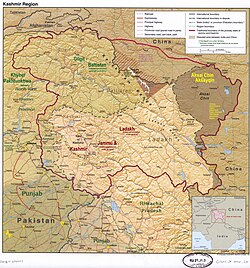
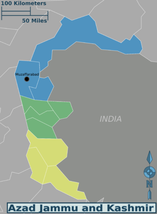
Azad Jammu and Kashmir[lower-alpha 1] abbreviated as AJK and colloquially referred to as simply Azad Kashmir, is a region administered by Pakistan as a nominally self-governing entity[9] and constituting the western portion of the larger Kashmir region, which has been the subject of a dispute between India and Pakistan since 1947.[1] Azad Kashmir also shares borders with the Pakistani provinces of Punjab and Khyber Pakhtunkhwa to the south and west, respectively. On its eastern side, Azad Kashmir is separated from the Indian union territory of Jammu and Kashmir (part of Indian-administered Kashmir) by the Line of Control (LoC), which serves as the de facto border between the Indian- and Pakistani-controlled parts of Kashmir. Geographically, it covers a total area of 13,297km2 (5,134sqmi) and has a total population of 4,045,366 as per the 2017 national census.
Northern Azad Kashmir lies in a region that experiences strong vibrations of the earth as a result of the Indian plate underthrusting the Eurasian plate.[10] A major earthquake in 2005 killed at least 100,000 people and left another three million people displaced, causing widespread devastation to the region's infrastructure and economy. Since then, with help from the Government of Pakistan and foreign aid, reconstruction of infrastructure is underway. Azad Kashmir's economy largely depends on agriculture, services, tourism, and remittances sent by members of the British Mirpuri community. Nearly 87% of Azad Kashmiri households own farm property,[11] and the region has the highest rate of school enrollment in Pakistan and a literacy rate of approximately 74%.[12][5]
Name
Azad Kashmir (Free Kashmir) was the title of a pamphlet issued by the Muslim Conference party at its 13th general session held in 1945 at Poonch.[13] It is believed to have been a response to the National Conference's Naya Kashmir (New Kashmir) programme.[14] Sources state that it was no more than a compilation of various resolutions passed by the party.[15] But its intent seems to have been to declare that the Muslims of Jammu and Kashmir were committed to the Muslim League's struggle for a separate homeland (Pakistan),[13] and that the Muslim Conference was the sole representative organisation of the Muslims of Kashmir.[14] However, the following year, the party passed an "Azad Kashmir resolution" demanding that the maharaja institute a constituent assembly elected on an extended franchise.[16] According to scholar Chitralekha Zutshi, the organisation's declared goal was to achieve responsible government under the aegis of the maharaja without association with either India or Pakistan.[17] The following year, the party workers assembled at the house of Sardar Ibrahim on July 19, 1947, reversed the decision, demanding that the Maharaja accede to Pakistan.[18][19]
Soon afterward, Sardar Ibrahim escaped to Pakistan and led the Poonch rebellion from there, with the assistance of Pakistan's prime minister Liaquat Ali Khan and other officials. Liaquat Ali Khan appointed a committee headed by Mian Iftikharuddin to draft a "declaration of freedom".[20] On October 4, an Azad Kashmir provisional government was declared in Lahore with Ghulam Nabi Gilkar as president under the assumed name "Mr. Anwar" and Sardar Ibrahim as the prime minister. Gilkar travelled to Srinagar and was arrested by the maharaja's government. Pakistani officials subsequently appointed Sardar Ibrahim as the president of the provisional government.[21][note 1]
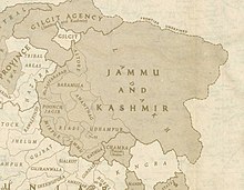
A 1946 map of the princely state of Jammu and Kashmir; present-day Azad Kashmir constitutes areas of the three western-most districts
At the time of the Partition of India in 1947, the British abandoned their suzerainty over the princely states, which were left with the options of joining India or Pakistan or remaining independent. Hari Singh, the maharaja of Jammu and Kashmir, wanted his state to remain independent.[23][24] Muslims in the western districts of the Jammu province (current day Azad Kashmir) and in the Frontier Districts province (current day Gilgit-Baltistan) had wanted to join Pakistan.[25]
In Spring 1947, an uprising against the maharaja broke out in Poonch, an area bordering the Rawalpindi division of West Punjab. The maharaja's administration is said to have started levying punitive taxes on the peasantry which provoked a local revolt and the administration resorted to brutal suppression. The area's population, swelled by recently demobilised soldiers following World War II, rebelled against the maharaja's forces and gained control of almost the entire district. Following this victory, the pro-Pakistan chieftains of the western districts of Muzaffarabad, Poonch and Mirpur proclaimed a provisional Azad Jammu and Kashmir government in Rawalpindi on October 3, 1947.[26][note 2] Ghulam Nabi Gilkar, under the assumed name "Mr. Anwar," issued a proclamation in the name of the provisional government in Muzaffarabad. However, this government quickly fizzled out with the arrest of Anwar in Srinagar.[28] On October 24, a second provisional government of Azad Kashmir was established at Palandri under the leadership of Sardar Ibrahim Khan.[29]
On October 21, several thousand Pashtun tribesmen from North-West Frontier Province poured into Jammu and Kashmir to help with the rebellion against the maharaja's rule. They were led by experienced military leaders and were equipped with modern arms. The maharaja's crumbling forces were unable to withstand the onslaught. The tribesmen captured the towns of Muzaffarabad and Baramulla, the latter of which is 32 kilometres (20mi) northwest of the state capital Srinagar. On October 24, the Maharaja requested military assistance from India, which responded that it was unable to help him unless he acceded to India. Accordingly, on October 26, 1947, Maharaja Hari Singh signed an Instrument of Accession, handing over control of defence, external affairs, and communications to the Government of India in return for military aid.[30] Indian troops were immediately airlifted into Srinagar.[31] Pakistan intervened subsequently.[24] Fighting ensued between the Indian and Pakistani armies, with the two areas of control more or less stabilised around what is now known as the "Line of Control".[32]
India later approached the United Nations, asking it to resolve the dispute, and resolutions were passed in favour of the holding of a plebiscite with regard to Kashmir's future. However, no such plebiscite has ever been held on either side, since there was a precondition that required the withdrawal of the Pakistani army along with the non-state elements and the subsequent partial withdrawal of the Indian army[33] from the parts of Kashmir under their respective control– a withdrawal that never took place.[34] In 1949, a formal cease-fire line separating the Indian- and Pakistani-controlled parts of Kashmir came into effect.
Following the 1949 cease-fire agreement with India, the government of Pakistan divided the northern and western parts of Kashmir that it controlled at the time of the cease-fire into the following two separately controlled political entities:
Azad Jammu and Kashmir (AJK)– the narrow, southern part, 400km (250mi) long, with a width varying from 15 to 65km (10 to 40mi).
In 1970, Yahya Khan's military administration promulgated a 'rudimentary' constitution, 'The Azad Jammu and Kashmir Government Act, 1970' which provided AJK a presidential system, an elected legislative assembly and 'considerable' autonomy. Snedden refers to it as having "delivered the most autonomy ever enjoyed by this region – or by any region in J&K." The central government only controlling foreign affairs, defence and currency, while the MKA was sidelined.[36]:121
Danish Khan in The Friday Times characterizes this development as providing "an avenue for citizens to draw attention from political elites towards immediate socio-economic and developmental concerns such as access to basic infrastructure and public goods," further stating "while public sector investments in infrastructure and social sectors have shown relative improvements over the years, the overarching narrative in the political sphere, spanning across party lines, remains heavily focused on the Jammu & Kashmir conflict rather than indigenous socio-economic development."[37]
The Constitution provides Kashmir its own President, Prime-Minister, High Court, Supreme Court, Auditor General and Chief Election Commissioner as well.[38] The 13th Amendment to the AJK Constitution, passed in Muzaffarabad empowered the AJK government, increased the powers of the elected assembly, granted Azad Kashmir greater financial and administrative powers and sought to make the federal territory more autonomous. The word "Act" was also deleted from the Constitution.[39]
At one time under Pakistani control, Kashmir's Shaksgam tract, a small region along the northeastern border of Gilgit–Baltistan, was provisionally ceded by Pakistan to the People's Republic of China in 1963 which helped in resolving China-Pakistan boundary dispute and now the forms part of China's Xinjiang Uygur Autonomous Region.
In 1972, the then current border between the Indian and Pakistani controlled parts of Kashmir was designated as the "Line of Control". This line has remained unchanged[40] since the 1972 Simla Agreement, which bound the two countries "to settle their differences by peaceful means through bilateral negotiations". Some political experts claim that, in view of that pact, the only solution to the issue is mutual negotiation between the two countries without involving a third party such as the United Nation.[41] The 1974 Interim Constitution Act was passed by the 48-member Azad Jammu and Kashmir unicameral assembly.[42]
In April 1997, the Nawaz Sharif government refused to grant constitutional status to Azad Jammu and Kashmir stating that "'The grant of constitutional rights to these people will amount to unilateral annexation of these areas."[43]
Geography
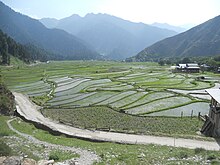
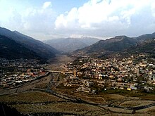
Landscape of Azad Kashmir
The northern part of Azad Jammu and Kashmir encompasses the lower area of the Himalayas, including Jamgarh Peak (4,734m or 15,531ft). However, Sarwali Peak (6326 m) in Neelum Valley is the highest peak in the state.[2]
The region receives rainfall in both the winter and the summer. Muzaffarabad and Pattan are among the wettest areas of Pakistan. Throughout most of the region, the average rainfall exceeds 1400mm, with the highest average rainfall occurring near Muzaffarabad (around 1800mm). During the summer season, monsoon floods of the rivers Jhelum and Leepa are common due to extreme rains and snow melting.
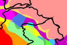
Climate
Map of the Köppen-Geiger climate classification
The southern parts of Azad Kashmir, including the Bhimber, Mirpur, and Kotli districts, have extremely hot weather in the summer and moderate cold weather in the winter. They receive rain mostly in monsoon weather.[citation needed]
In the central and northern parts of the state, the weather remains moderately hot in the summer and cold and chilly in the winter. Snowfall also occurs there in December and January.[citation needed]
The region receives rainfall in both the winter and the summer. Muzaffarabad and Pattan are among the wettest areas of the state, but they don't receive snow. Throughout most of the region, the average rainfall exceeds 1400mm, with the highest average rainfall occurring near Muzaffarabad (around 1800mm). During summer, monsoon floods of the Jhelum and Leepa rivers are common, due to high rainfall and melting snow.[citation needed]
Azad Jammu and Kashmir (AJK) is nominally a self-governing state,[44] but ever since the 1949 ceasefire between Indian and Pakistani forces, Pakistan has exercised control over the state without incorporating it into Pakistan.[2][45] Azad Kashmir has its own elected president, prime minister, legislative assembly, high court (with Azam Khan as its present chief justice), and official flag.[46]
Azad Kashmir's budget and tax affairs, are dealt with by the Azad Jammu and Kashmir Council rather than by Pakistan's Central Board of Revenue. The Azad Jammu and Kashmir Council is a supreme body consisting of 14 members, 8 from the government of Azad Jammu and Kashmir and 6 from the government of Pakistan. Its chairman/chief executive is the prime minister of Pakistan. Other members of the council are the president and the prime minister of Azad Kashmir (or an individual nominated by her/him) and 6 members of the AJK Legislative Assembly.[46][45] Azad Kashmir Day is celebrated in Azad Jammu and Kashmir on October 24, which is the day that the Azad Jammu and Kashmir government was created in 1947. Pakistan has celebrated Kashmir Solidarity Day on February 5 of each year since 1990 as a day of protest against India's de facto sovereignty over its State of Jammu and Kashmir.[47] That day is a national holiday in Pakistan.[48] Pakistan observes the Kashmir Accession Day as Black Day on October 27 of each year since 1947 as a day of protest against the accession of Jammu and Kashmir State to India and its military presence in the Indian-controlled parts of Jammu and Kashmir.
Brad Adams, the Asia director at the U.S.-based NGOHuman Rights Watch said in 2006: "Although 'azad' means 'free,' the residents of Azad Kashmir are anything but; the Pakistani authorities govern the Azad Kashmir government with tight controls on basic freedoms."[49] Scholar Christopher Snedden has observed that despite tight controls, the people of Azad Kashmir have generally accepted whatever Pakistan has done to them, which in any case has varied little from how most Pakistanis have been treated (by Pakistan). According to Christopher Snedden, one of the reasons for this was that the people of Azad Kashmir had always wanted to be part of Pakistan.[50]
Consequently, having little to fear from a pro-Pakistan population devoid of options,[50] Pakistan imposed its will through the Federal Ministry of Kashmir Affairs and failed to empower the people of Azad Kashmir, allowing genuine self-government for only a short period in the 1970s. According to the interim constitution that was drawn up in the 1970s, the only political parties that are allowed to exist are those that pay allegiance to Pakistan: "No person or political party in Azad Jammu and Kashmir shall be permitted... activities prejudicial or detrimental to the State's accession to Pakistan."[50] The pro-independence Jammu and Kashmir Liberation Front has never been allowed to contest elections in Azad Kashmir.[51] While the interim constitution does not give them a choice, the people of Azad Kashmir have not considered any option other than joining Pakistan.[50] Except in a legal sense, Azad Kashmir has been fully integrated into Pakistan.[50]
Azad Kashmir is home to a vibrant civil society. One of the organizations active in the territory and inside Pakistan is YFK-International Kashmir Lobby Group, an NGO that seeks better India-Pakistan relations through conflict resolution in Kashmir.
Development project
According to the project report by the Asian Development Bank, the bank has set out development goals for Azad Kashmir in the areas of health, education, nutrition, and social development. The whole project is estimated to cost US$76 million.[52]Germany, between 2006 and 2014, has also donated $38 million towards the AJK Health Infrastructure Programme.[53]
The population of Azad Kashmir, according to the preliminary results of the 2017 Census, is 4.045 million.[55] The website of the AJK government reports the literacy rate to be 74%, with the enrolment rate in primary school being 98% and 90% for boys and girls respectively.[56]
The population of Azad Kashmir is almost entirely Muslim. The people of this region culturally differ from the Kashmiris living in the Kashmir Valley of Jammu and Kashmir and are closer to the culture of Jammu. Mirpur, Kotli, and Bhimber are all old towns of the Jammu region.[57]
Religion
Azad Jammu and Kashmir has an almost entirely Muslim population. According to data maintained by Christian community organizations, there are around 4,500 Christian residents in the region. Bhimber is home to most of them, followed by Mirpur and Muzaffarabad. A few dozen families also live in Kotli, Poonch, and Bagh. However, the Christian community has been struggling to get residential status and property rights in AJK.
There is no official data on the total number of Bahais in AJK. Only six Bahai families are known to be living in Muzaffarabad with others living in rural areas.
The followers of the Ahmadi faith are estimated to be somewhere between 20,000 and 25,000, and most of them live in Kotli, Mirpur, Bhimber, and Muzaffarabad.[58]
Christopher Snedden writes that most of the native residents of Azad Kashmir are not of Kashmiri ethnicity; rather, they could be called "Jammuites" due to their historical and cultural links with that region, which is coterminous with neighbouring Punjab and Hazara.[59][60] Because their region was formerly a part of the princely state of Jammu and Kashmir and is named after it, many Azad Kashmiris have adopted the "Kashmiri" identity, whereas in an ethnolinguistic context, the term "Kashmiri" would ordinarily refer to natives of the Kashmir Valley region.[61] The population of Azad Kashmir has strong historical, cultural and linguistic affinities with the neighbouring populations of upper Punjab and Potohar region of Pakistan,[62][63] whereas the Sudhans have the oral tradition of the Pashtuns.[64][65]
The main communities living in this region are:[66]
Gujjars – They are an agricultural tribe and are estimated to be the largest community living in the ten districts of Azad Kashmir.[66][67][68] They are estimated to number around 800,000.[69]
Sudhans – (also known as Sadozai, Sardar) are the second largest tribe, living mainly in the districts of Poonch, Sudhanoti, Bagh, and Kotli in Azad Kashmir, and allegedly originating from the Pashtun areas.[70][66][67] With a population of more than 500,000, together with the Rajputs, they are the source of most of Azad Kashmir's political leaders.[69]
Jats – They are one of the larger communities of AJK and primarily inhabit the districts of Mirpur, Bhimber, and Kotli. A large Mirpuri population lives in the U.K. and it is estimated that more people of Mirpuri origins are now residing in the U.K. than in the Mirpur district, which retains strong ties with the U.K.[66][71] Mirpuri Jats number approximately 300 000.[69]
Rajputs – They are spread across the territory, and they number a little under 500,000. Together with the Sundhans, they are the source of most of Azad Kashmir's political class.[69]
Awans – A clan with significant numbers in Azad Jammu and Kashmir, living mainly in the Bagh, Poonch, Hattian Bala, and Muzaffarabad. Awans also reside in Punjab and Khyber Pakhtunkhwa in large numbers.[66][67][68]
Dhund – They are a large clan in Azad Jammu and Kashmir and live mostly in the Bagh, Hattian Bala, and Muzaffarabad districts. They also inhabit Abbottabad and upper Potohar Punjab in large numbers.[66][67][68]
The official language of Azad Kashmir is Urdu,[74][note 3] while English is used in higher domains. The majority of the population, however, are native speakers of other languages. The foremost among these is Pahari–Pothwari with its various dialects. There are also sizeable communities speaking Kashmiri (mostly in the north), Gujari (throughout the territory), and Dogri (in the south), as well as pockets of speakers of Kundal Shahi, Shina and Pashto. With the exception of Pashto and English, those languages belong to the Indo-Aryan language family.
The dialects of the Pahari-Pothwari language complex cover most of the territory of Azad Kashmir. Those are also spoken across the Line of Control in the neighbouring areas of Indian Jammu and Kashmir and are closely related both to Punjabi to the south and Hinko to the northwest. The language variety in the southern districts of Azad Kashmir is known by a variety of names – including Mirpuri, Pothwari and Pahari – and is closely related to the Pothwari proper spoken to the east in the Pothohar region of Punjab. The dialects of the central districts of Azad Kashmir are occasionally referred to in the literature as Chibhali or Punchi, but the speakers themselves usually call them Pahari, an ambiguous name that is also used for several unrelated languages of the lower Himalayas. Going north, the speech forms gradually change into Hindko. Today, in the Muzaffarabad District the preferred local name for the language is Hindko, although it is still apparently more closely related to the core dialects of Pahari.[75] Further north in the Neelam Valley the dialect, locally also known as Parmi, can more unambiguously be subsumed under Hindko.[76]
Another major language of Azad Kashmir is Gujari. It is spoken by several hundred thousand[note 4] people among the traditionally nomadic Gujars, many of whom are nowadays settled. Not all ethnic Gujars speak Gujari, the proportion of those who have shifted to other languages is probably higher in southern Azad Kashmir.[77] Gujari is most closely related to the Rajasthani languages (particularly Mewati), although it also shares features with Punjabi.[78] It is dispersed over large areas in northern Pakistan and India. Within Pakistan, the Gujari dialects of Azad Kashmir are more similar, in terms of shared basic vocabulary and mutual intelligibility, to the Gujar varieties of the neighbouring Hazara region than to the dialects spoken further to the northwest in Khyber Pakhtunkhwa and north in Gilgit.[79]
There are scattered communities of Kashmiri speakers,[80] notably in the Neelam Valley, where they form the second-largest language group after speakers of Hindko.[81] There have been calls for the teaching of Kashmiri (particularly in order to counter India's claim of promoting the culture of Kashmir), but the limited attempts at introducing the language at the secondary school level have not been successful, and it is Urdu, rather than Kashmiri, that Kashmiri Muslims have seen as their identity symbol.[82] There is an ongoing process of gradual shift to larger local languages,[74] but at least in the Neelam Valley there still exist communities for whom Kashmiri is the sole mother tongue.[83]
There are speakers of Dogri in the southernmost district of Bhimber, where they are estimated to represent almost a third of the district's population.[73] In the northernmost district of Neelam, there are small communities of speakers of several other languages. Shina, which like Kashmiri belongs to the broad Dardic group, is present in two distinct varieties spoken altogether in three villages. Pashto, of the Iranian subgroup and the majority language in the neighbouring province of Khyber Pakhtunkhwa, is spoken in two villages, both situated on the Line of Control. The endangered Kundal Shahi is native to the eponymous village and it is the only language not found outside Azad Kashmir.[84]
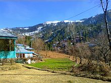
Neelum Valley is a tourist destination in Azad Kashmir.
As of 2021, GDP of Azad Jammu and Kashmir was estimated to be 10 billion pounds, giving per capita an income of £5604.[85] Historically the economy of Azad Kashmir has been agricultural which meant that land was the main source or mean of production. This means that all food for immediate and long-term consumption was produced from the land. The produce included various crops, fruits, vegetables, etc. The land was also the source of other livelihood necessities such as wood, fuel, grazing for animals which then turned into dairy products. Because of this land was also the main source of revenue for the governments whose primary purpose for centuries was to accumulate revenue.[86]
Agriculture is a major part of Azad Kashmir's economy. Low-lying areas that have high populations grow crops like barley, mangoes, millet, corn (maize), and wheat, and also raise cattle. In the elevated areas that are less populated and more spread out, forestry, corn, and livestock are the main sources of income. There are mineral and marble resources in Azad Kashmir close to Mirpur and Muzaffarabad. There are also graphite deposits at Mohriwali. There are also reservoirs of low-grade coal, chalk, bauxite, and zircon. Local household industries produce carved wooden objects, textiles, and dhurrie carpets.[2] There is also an arts and crafts industry that produces such cultural goods as namdas, shawls, pashmina, pherans, Papier-mâché, basketry copper, rugs, wood carving, silk and woolen clothing, patto, carpets, namda gubba, and silverware. Agricultural goods produced in the region include mushrooms, honey, walnuts, apples, cherries, medicinal herbs and plants, resin, deodar, kail, chir, fir, maple, and ash timber.[2][45][87]
The migration to the UK was accelerated and by the completion of Mangla Dam in 1967 the process of 'chain migration' became in full flow. Today, remittances from British Mirpuri community make a critical role in AJK's economy. In the mid-1950s various economic and social development processes were launched in Azad Kashmir. In the 1960s, with the construction of the Mangla Dam in Mirpur District, the Azad Jammu and Kashmir Government began to receive royalties from the Pakistani government for the electricity that the dam provided to Pakistan. During the mid-2000s, a multibillion-dollar reconstruction began in the aftermath of the 2005 Kashmir earthquake.[88]
In addition to agriculture, textiles, and arts and crafts, remittances have played a major role in the economy of Azad Kashmir. One analyst estimated that the figure for Azad Kashmir was 25.1% in 2001. With regard to annual household income, people living in the higher areas are more dependent on remittances than are those living in the lower areas.[89] In the latter part of 2006, billions of dollars for development were mooted by international aid agencies for the reconstruction and rehabilitation of earthquake-hit zones in Azad Kashmir, though much of that amount was subsequently lost in bureaucratic channels, leading to considerable delays in help getting to the neediest. Hundreds of people continued to live in tents long after the earthquake.[88] A land-use plan for the city of Muzaffarabad was prepared by the Japan International Cooperation Agency.
Tourist destinations in the area include the following:
Sudhanoti is one of the ten districts of Azad Kashmir in Pakistan. Sudhanoti is located 90km (56mi) away from Islamabad, the Capital of Pakistan. It is connected with Rawalpindi and Islamabad through Azad Pattan road.
The literacy rate in Azad Kashmir was 62% in 2004, higher than in any other region of Pakistan.[90] The literacy rate of Azad Kashmir was 76.60% in 2018.[91] It remained at 79.80% in 2019. According to the 2020–2021 census, the literacy rate in Azad Kashmir was 91.34%.[92] However, only 2.2% were graduates, compared to the average of 2.9% for Pakistan.[93]
Football, cricket, and volleyball are very popular in Azad Kashmir. Many tournaments are also held throughout the year and in the holy month of Ramazan, night-time flood-lit tournaments are also organised.
New Mirpur City has a cricket stadium (Quaid-e-Azam Stadium) which has been taken over by the Pakistan Cricket Board for renovation to bring it up to the international standards. There is also a cricket stadium in Muzaffarabad with a capacity of 8,000 people. This stadium has hosted 8 matches of the Inter-District Under 19 Tournament 2013.
The northern part of Azad Jammu and Kashmir encompasses the lower part of the Himalayas, including Jamgarh Peak (15,531 feet, or 4,734 meters). However, Sarwali peak in the Neelum Valley is the highest peak in the state.[96] Fertile, green, mountainous valleys are characteristic of Azad Kashmir's geography, making it one of the most beautiful regions on the subcontinent.[97]
The southern parts of Azad Kashmir including Bhimber, Mirpur and Kotli districts has extremely hot weather in summers and moderate cold weather in winters. It receives rains mostly in monsoon weather.
In the central and northern parts of state weather remains moderate hot in summers and very cold and chilly in winter. Snow fall also occurs there in December and January.
This region receives rainfall in both winters and summers. Muzaffarabad and Pattan are among the wettest areas of the state. Throughout most of the region, the average rainfall exceeds 1400mm, with the highest average rainfall occurring near Muzaffarabad (around 1800mm). During summer, monsoon floods of the Jhelum and Leepa river are common, due to high rainfall and melting snow.
↑ The official with direct involvement in the affair was the Commissioner of Rawalpindi Division, Khawaja Abdul Rahim. He was assisted by Nasim Jahan, the wife of Colonel Akbar Khan.[22]
↑ Officially, the Mirpur and Poonch districts were in the Jammu province of the state and Muzaffarabad was in the Kashmir province. All three provinces spoke languages related to Punjabi, not the Kashmiri language spoken in the Kashmir Valley.[27]
↑ Snedden 2013, p. 176: On p.29, the census report states that Urdu is the official language of the government of Azad Kashmir, with Kashmiri, Pahari, Gojri, Punjabi, Kohistani, Pushto, and Sheena 'frequently spoken in Azad Kashmir'. Yet, when surveyed about their 'mother tongue', Azad Kashmiris' choices were limited to selecting from Pakistan's major languages: Urdu, Punjabi, Sindhi, Pushto, Balochi, Saraiki, and 'others'; not surprisingly, 2.18 million of Azad Kashmir's 2.97 million people chose 'others'.
↑ Hallberg & O'Leary (1992, p.96) report two rough estimates for the total population of Gujari speakers in Azad Kashmir: 200,000 and 700,000, both from the 1980s.
Related Research Articles
Muzaffarabad is a city in Pakistani-administered Azad Kashmir in the disputed Kashmir region. It is the largest city and the capital of Azad Kashmir, which is a Pakistani-administered administrative territory.
Mirpur, officially known as New Mirpur City, is the capital of Mirpur district located in Azad Kashmir, Pakistan which has been subject of the larger Kashmir dispute between Pakistan and India since 1947. It is the second largest city of Azad Kashmir and the 74th largest city in Pakistan.
Bagh District is a district of Pakistan-administered Azad Kashmir in the disputed Kashmir region. It is one of the ten districts of Azad Jammu and Kashmir. Previously part of Poonch District, Bagh was established as a separate district in 1988.
Bhimber District is a district of Pakistan-administered Azad Kashmir in the disputed Kashmir region. It is the southernmost of the 10 districts of Pakistan's territory of Azad Kashmir. It has an area of 1,516 km², and the district headquarter is the town of Bhimber.
Kotli District is a district of Pakistan-administered Azad Kashmir in the Azad Kashmir region. It is one of the 10 districts of Pakistan's dependent territory of Azad Kashmir. It is bounded on the north by the Sudhanoti District and the Poonch District, on the north-east by the Poonch District of Indian-administered Jammu and Kashmir, on the south by the Mirpur and Bhimber districts, and on the west by the Rawalpindi District on Pakistan's Punjab Province. Kotli is the biggest district of Azad Kashmir by population and the second biggest by land area, after the Neelum District. The district headquarters is the city of Kotli. The main native languages are Pahari, and Gujari.
Poonch District is a district of Pakistan-administered Azad Kashmir in the disputed Kashmir region. It is one of the 10 districts of this Pakistan-administered territory. It is bounded on the north by Bagh District, on the north-east by Haveli District, on the south-east by the Poonch District of Indian-administered Kashmir, on the south by Azad Kashmir's Sudhanoti and Kotli districts, and on the west by Rawalpindi District of Pakistan's Punjab Province. The Poonch District is part of the greater Kashmir dispute between India and Pakistan. The district headquarters is the city of Rawalakot. It is the third most populous district of Azad Kashmir.
Mirpur District is a district of Pakistan-administered Azad Kashmir in the disputed Kashmir region. It is one of the 10 districts of Pakistan's territory of Azad Kashmir. The Mirpur District is bounded on the north by the Kotli District, on the east by the Bhimber District, on the south by the Gujrat District of Punjab, Pakistan, on the south-west by the Jhelum District of Punjab, Pakistan, and on the west by its Rawalpindi District. The district is named after its main city, Mirpur. The Mirpur District has a population of 456,200 and covers an area of 1,010 km2 (390 sq mi). The district is mainly mountainous with some plains. The Mirpur District has a humid subtropical climate which closely resembles that of the Gujrat District and the Jhelum District, the adjoining districts of Pakistan's Punjab Province.
Poonch or Punch is a district of the Jammu division of Indian-administered Jammu and Kashmir in the disputed Kashmir region. With headquarters in the town of Poonch, it is bounded by the Line of Control on three sides. The 1947-48 war between India and Pakistan divided the earlier district into two parts. One went to Pakistan and the other became part of the then-Indian state of Jammu and Kashmir.
Rajouri is a district in the Jammu division of Indian-administered Jammu and Kashmir in the disputed Kashmir region. The Line of Control, between the Indian- and Pakistani-administered Jammu and Kashmir, lies to its west, Poonch to its north, the Reasi district to the east and the Jammu district to its south. Rajouri is famous for its "Kalari". Representing an ancient principality, Rajouri was a joint district, along with Reasi, at the time of princely state's accession to India in 1947. The two tehsils were separated and Rajouri was merged with the Poonch district. Rajouri again became a separate district along with Reasi in 1968 till 2006 when both were separated again. The Rajouri district comprises 13 tehsils (boroughs). The land is mostly fertile and mountainous. Maize, wheat and rice are the main crops of the area and the main source of the irrigation is the river Tawi that originates from the mountains of Pir Panjal.
Kupwara district is an administrative district of Indian-administered Jammu and Kashmir in the disputed Kashmir region. It is one of the 10 districts located in the Kashmir Valley Division of Indian administered Kashmir. The Pohru River and Mawar river are two main rivers in the district. Both of them meet Jhelum river in Baramulla district.
Kathua district is an administrative district in the Jammu division of Indian-administered Jammu and Kashmir in the disputed Kashmir region. It is surrounded by Jammu to the northwest, the Doda and Udhampur districts to the north, the state of Himachal Pradesh to the east, Punjab to the south, and Pakistan's working boundary to the west. Its terrain is diverse, consisting of rich agricultural areas along the Punjab/Kashmir border, plains sweeping eastward to the foothills of the Himalaya, and the mountainous Pahari region in the east.
Poonch District was a district of the princely state of Jammu and Kashmir, which is currently divided between India and Pakistan. The Pakistani part of the erstwhile district is now the Poonch Division in the Azad Kashmir territory, whilst the Indian part of the district is the Poonch district in Jammu and Kashmir. The capital of the Pakistan-controlled side is Rawalakot; while the capital of the Indian-controlled side is Poonch.
Neelum is a district of Pakistan-administered Azad Kashmir in the disputed Kashmir region. It is the northernmost of 10 districts located within the Pakistani-administered territory of Azad Kashmir. Taking up the larger part of the Neelum Valley, the district had a population of around 191,000 people. It was among the worst-hit areas of Pakistan during the 2005 Kashmir earthquake.
The Haveli District is a district of Pakistan-administered Azad Kashmir in the disputed Kashmir region. It is one of the 10 districts of the Pakistan-administered territory of Azad Kashmir. It was previously a tehsil of the Bagh District but was promoted to the district status on 1 July 2009.
The history of Azad Kashmir, a disputed part of the Kashmir region currently administered by Pakistan, is related to the history of the Kashmir region during the Dogra rule. Azad Kashmir borders the Pakistani provinces of Punjab and Khyber Pakhtunkhwa to the south and west respectively, Gilgit–Baltistan to the north, and the Indian union territory of Jammu and Kashmir to the east. The region is claimed by India and has been the subject of a dispute between India and Pakistan since 1947.
The Kashmir division is a revenue and administrative division of the Indian-administered Jammu and Kashmir in the disputed Kashmir region. It comprises the Kashmir Valley, bordering the Jammu Division to the south and Ladakh to the east. The Line of Control forms its boundary with the Pakistani-administered territories of Gilgit−Baltistan and Azad Jammu and Kashmir to the north and west and west, respectively.
The Mirpuri diaspora constitutes individuals with an origin in the Mirpur District of Azad Kashmir, Pakistan, now living outside that district. Migration from Mirpur started occurring in the 1920s, when many Mirpuris left for Bombay to work on merchant ships. During the partition of British India in 1947, many Mirpuri Hindus and Mirpuri Sikhs were forced to flee to cities in the princely state of Jammu and Kashmir. The construction of the Mangla Dam by the Pakistani Government in the 1960s caused many of Mirpuri Muslims to migrate to the United Kingdom to work as labourers.
The Azad Kashmir Regular Force (AKRF), formerly known as the Kashmir Liberation Forces(KLF), were the irregular forces of Azad Kashmir until 1948. They then were taken over by the government of Pakistan and converted into a regular force. In this form, the unit became part of the country's paramilitary forces, operating out of the nominally self-governing territory of Azad Jammu and Kashmir. The AKRF was altered from a functioning paramilitary force and merged into the Pakistan Army as an infantry regiment following the Indo-Pakistani War of 1971.
In spring 1947, an uprising against the Maharaja Hari Singh of Jammu and Kashmir broke out in the Poonch jagir, an area bordering the Rawalpindi district of West Punjab and the Hazara district of the North-West Frontier Province in the future Pakistan. It was driven by grievances such as high taxes, the Maharaja's neglect of World War veterans, and above all, Muslim nationalism with a desire to join Pakistan. The leader of the rebellion, Sardar Muhammad Ibrahim Khan, escaped to Lahore by the end of August 1947 and persuaded the Pakistani authorities to back the rebellion. In addition to the backing, Prime Minister Liaquat Ali Khan authorised an invasion of the state, by the ex-Indian National Army personnel in the south and a force led by Major Khurshid Anwar in the north. These invasions eventually led to the First Kashmir War fought between India and Pakistan, and the formation of Azad Kashmir provisional government. The Poonch jagir has since been divided across Azad Kashmir, administered by Pakistan and the state of Jammu and Kashmir, administered by India.
Kashmiris in Azad Kashmir are the ethnic Kashmiri people who reside in Azad Kashmir, a territory which constitutes part of Pakistani-administered Kashmir since the end of the First Kashmir War. Their demographic includes up to 40,000 registered Kashmiri refugees who have fled the Kashmir Valley, located in Indian-administered Kashmir, to Pakistan since the late 1980s due to conflict in the region. As of 2010, only around 60 percent of Kashmiri refugees had acquired Pakistani citizenship.
References
1 2 The application of the term "administered" to the various regions of Kashmir and a mention of the Kashmir dispute is supported by the tertiary sources (a) through (e), reflecting due weight in the coverage. Although "controlled" and "held" are also applied neutrally to the names of the disputants or to the regions administered by them, as evidenced in sources (h) through (i) below, "held" is also considered politicized usage, as is the term "occupied," (see (j) below). (a) Kashmir, region Indian subcontinent, Encyclopaedia Britannica, archived from the original on August 13, 2019, retrieved August 15, 2019 (subscription required) Quote: "Kashmir, region of the northwestern Indian subcontinent ... has been the subject of dispute between India and Pakistan since the partition of the Indian subcontinent in 1947. The northern and western portions are administered by Pakistan and comprise three areas: Azad Kashmir, Gilgit, and Baltistan, the last two being part of a territory called the Northern Areas. Administered by India are the southern and southeastern portions, which constitute the state of Jammu and Kashmir but are slated to be split into two union territories."; (b) Pletcher, Kenneth, Aksai Chin, Plateau Region, Asia, Encyclopaedia Britannica, archived from the original on April 2, 2019, retrieved August 16, 2019 (subscription required) Quote: "Aksai Chin, Chinese (Pinyin) Aksayqin, portion of the Kashmir region, at the northernmost extent of the Indian subcontinent in south-central Asia. It constitutes nearly all the territory of the Chinese-administered sector of Kashmir that is claimed by India to be part of the Ladakh area of Jammu and Kashmir state."; (c) "Kashmir", Encyclopedia Americana, Scholastic Library Publishing, 2006, p.328, ISBN978-0-7172-0139-6, archived from the original on January 17, 2023, retrieved September 20, 2019 C. E Bosworth, University of Manchester Quote: "KASHMIR, kash'mer, the northernmost region of the Indian subcontinent, administered partlv by India, partly by Pakistan, and partly by China. The region has been the subject of a bitter dispute between India and Pakistan since they became independent in 1947"; (d) Osmańczyk, Edmund Jan (2003), Encyclopedia of the United Nations and International Agreements: G to M, Taylor & Francis, pp.1191–, ISBN978-0-415-93922-5, archived from the original on January 17, 2023, retrieved June 12, 2023 Quote: "Jammu and Kashmir: Territory in northwestern India, subject to a dispute between India and Pakistan. It has borders with Pakistan and China." (e) Talbot, Ian (2016), A History of Modern South Asia: Politics, States, Diasporas, Yale University Press, pp.28–29, ISBN978-0-300-19694-8 Quote: "We move from a disputed international border to a dotted line on the map that represents a military border not recognized in international law. The line of control separates the Indian and Pakistani administered areas of the former Princely State of Jammu and Kashmir."; (f) Skutsch, Carl (2015) [2007], "China: Border War with India, 1962", in Ciment, James (ed.), Encyclopedia of Conflicts Since World War II (2nded.), London and New York: Routledge, p.573, ISBN978-0-7656-8005-1, The situation between the two nations was complicated by the 1957–1959 uprising by Tibetans against Chinese rule. Refugees poured across the Indian border, and the Indian public was outraged. Any compromise with China on the border issue became impossible. Similarly, China was offended that India had given political asylum to the Dalai Lama when he fled across the border in March 1959. In late 1959, there were shots fired between border patrols operating along both the ill-defined McMahon Line and in the Aksai Chin. (g) Clary, Christopher (2022), The Difficult Politics of Peace: Rivalry in Modern South Asia, Oxford and New York: Oxford University Press, p.109, ISBN9780197638408, Territorial Dispute: The situation along the Sino-Indian frontier continued to worsen. In late July (1959), an Indian reconnaissance patrol was blocked, "apprehended," and eventually expelled after three weeks in custody at the hands of a larger Chinese force near Khurnak Fort in Aksai Chin. ... Circumstances worsened further in October 1959, when a major class at Kongka Pass in eastern Ladakh led to nine dead and ten captured Indian border personnel, making it by far the most serious Sino-Indian class since India's independence. (h) Bose, Sumantra (2009), Kashmir: Roots of Conflict, Paths to Peace, Harvard University Press, pp.294, 291, 293, ISBN978-0-674-02855-5 Quote: "J&K: Jammu and Kashmir. The former princely state that is the subject of the Kashmir dispute. Besides IJK (Indian-controlled Jammu and Kashmir. The larger and more populous part of the former princely state. It has a population of slightly over 10 million, and comprises three regions: Kashmir Valley, Jammu, and Ladakh.) and AJK ('Azad" (Free) Jammu and Kashmir. The more populous part of Pakistani-controlled J&K, with a population of approximately 2.5 million.), it includes the sparsely populated "Northern Areas" of Gilgit and Baltistan, remote mountainous regions which are directly administered, unlike AJK, by the Pakistani central authorities, and some high-altitude uninhabitable tracts under Chinese control." (i) Fisher, Michael H. (2018), An Environmental History of India: From Earliest Times to the Twenty-First Century, Cambridge University Press, p.166, ISBN978-1-107-11162-2 Quote: "Kashmir’s identity remains hotly disputed with a UN-supervised “Line of Control” still separating Pakistani-held Azad (“Free”) Kashmir from Indian-held Kashmir."; (j) Snedden, Christopher (2015), Understanding Kashmir and Kashmiris, Oxford University Press, p.10, ISBN978-1-84904-621-3 Quote:"Some politicised terms also are used to describe parts of J&K. These terms include the words 'occupied' and 'held'."
↑ Bose, Sumantra (2009). Contested Lands. Harvard University Press. p.193. ISBN978-0-674-02856-2. Archived from the original on January 17, 2023. Retrieved December 21, 2016. Azad Kashmir – 'Free Kashmir,' the more populated and nominally self-governing part of Pakistani-controlled Kashmir
Bose, Sumantra (2009). Contested Lands. Harvard University Press. p.193. ISBN978-0-674-02856-2. Archived from the original on January 17, 2023. Retrieved December 21, 2016. Azad Kashmir – 'Free Kashmir,' the more populated and nominally self-governing part of Pakistani-controlled Kashmir
"Territorial limits". Herald. May 7, 2015. Archived from the original on July 25, 2015. Retrieved July 24, 2015. These are self-ruled autonomous regions. But restrictions apply.
↑ "Azad Kashmir". www.britannica.com. Archived from the original on October 12, 2020. Retrieved April 17, 2021.
↑ Snedden 2013, p. 14: "Similarly, Muslims in Western Jammu Province, particularly in Poonch, many of whom had martial capabilities, and Muslims in the Frontier Districts Province strongly wanted J&K to join Pakistan.".
1 2 Zutshi, Chitralekha, ed. (2018). Kashmir: history, politics, representation. Cambridge New York NY Port Melbourne New Delhi Singapore: Cambridge University Press. ISBN978-1-108-40210-1.
↑ Ershad, Mahmud (September 1, 2006). "Status of AJK in Political Milieu". Institute of Policy Studies. Archived from the original on May 17, 2023. Retrieved May 17, 2023. There is a consensus that AJK does not belong to Pakistan geographically yet it is not an independent state either.
↑ With Friends Like These... (Report). Vol.18. Human Rights Watch. September 2006. Archived from the original on December 2, 2013. Retrieved November 24, 2013.
↑ Snedden, Christopher (September 15, 2015). Understanding Kashmir and Kashmiris. Oxford University Press. pp.21–24. ISBN978-1-84904-622-0. Archived from the original on January 17, 2023. Retrieved March 20, 2018. Confusingly, the term 'Kashmiri' also has wider connotations and uses. Some people in Azad Kashmir call themselves 'Kashmiris' This is despite most Azad Kashmiris not being of Kashmiri ethnicity. Indeed, most of their ethnic, cultural and historical links have been, and remain, with areas to the south and west of Azad Kashmir, chiefly Punjab and the North-West Frontier Province (NWFP), now called Khyber Pakhtunkhwa Province. Nevertheless, Azad Kashmiris call themselves Kashmiris because of their region's historical connections with the former princely state of J&K that popularly was called Kashmir. Some Azad Kashmiris also call themselves Kashmiris simply because their region's official name, Azad Jammu and Kashmir, has the word Kashmir in it. (Using the same logic, Azad Kashmiris could call themselves "'Jammuites', which historically and culturally would be more accurate, or even 'Azadi- ites'.)
↑ Jabeen, Nazish; Malik, Sajid (June 2014), "Consanguinity and Its Sociodemographic Differentials in Bhimber District, Azad Jammu and Kashmir, Pakistan", Journal of Health, Population, and Nutrition, 32 (2): 301–313, PMC4216966, PMID25076667, Kashmiri population in the northeast of Pakistan has strong historical, cultural and linguistic affinities with the neighbouring populations of upper Punjab and Potohar region of Pakistan.
↑ Ballard, Roger (March 2, 1991), "Kashmir Crisis: View from Mirpur"(PDF), Economic and Political Weekly, 26 (9/10): 513–517, JSTOR4397403, archived from the original(PDF) on March 4, 2016, retrieved July 19, 2020, ... they are best seen as forming the eastern and northern limits of the Potohari Punjabi culture which is otherwise characteristic of the upland parts of Rawalpindi and Jhelum Districts
↑ Syed Ali (1998). "South Asia: The Perils of Covert Coercion". In Lawrence Freedman (ed.). Strategic Coercion: Concepts and Cases. Oxford University Press. p.253. ISBN0-19-829349-6. Poonch at the time of partition was predominantly Muslim and the overwhelming majority of them were Sudhans, who were descendants of Pashtuns of Afghanistan, settled in the region some centuries ago.
↑ Snedden 2013, p. 43: "Sudhans from Poonch considered themselves to be Sudho Zai Pathans (Pukhtoons), which explained why the Pashtun tribesmen from NWFP province lost no time coming to help Jammu and Kashmir's Muslims in 1947..".
1 2 3 4 "District Profile - Bagh"(PDF). Earthquake Reconstruction and Rehabilitation Authority. June 2007. Archived from the original(PDF) on September 24, 2015. Retrieved August 31, 2015.
↑ Snedden, Christopher (2012). The Untold Story of the People of Azad Kashmir. Columbia University Press. p.xix. ISBN9780231800204. Archived from the original on January 17, 2023. Retrieved June 12, 2019. Sudhan/Sudhozai – one of the main tribes of (southern) Poonch, allegedly originating from Pashtun areas.
1 2 Statistical Year Book 2020(PDF). Muzaffarabad: AJ&K Bureau Of Statistics. pp.131, 140. Archived(PDF) from the original on October 9, 2022. Retrieved March 3, 2022.
↑ Akhtar & Rehman 2007, p.68. The conclusion is based on lexical similarity and the comparison is with the Hindko of the Kaghan Valley and with the Pahari of the Murree Hills.
Akhtar, Raja Nasim; Rehman, Khawaja A. (2007). "The Languages of the Neelam Valley". Kashmir Journal of Language Research. 10 (1): 65–84. ISSN1028-6640.
Hallberg, Calinda E.; O'Leary, Clare F. (1992). "Dialect Variation and Multilingualism among Gujars of Pakistan". In O'Leary, Clare F.; Rensch, Calvin R.; Hallberg, Calinda E. (eds.). Hindko and Gujari. Sociolinguistic Survey of Northern Pakistan. Islamabad: National Institute of Pakistan Studies, Quaid-i-Azam University and Summer Institute of Linguistics. pp.91–196. ISBN969-8023-13-5.
Rahman, Tariq (2002). Language, ideology and power: language learning among the Muslims of Pakistan and North India. Karachi: Oxford University Press. ISBN978-0-19-579644-5.
This page is based on this Wikipedia article Text is available under the CC BY-SA 4.0 license; additional terms may apply. Images, videos and audio are available under their respective licenses.