Aksai Chin was first mentioned by Muhammad Amin, the Yarkandi guide of the Schlagintweit brothers, who were contracted in 1854 by the British East India Company to explore Central Asia. Amin explained its meaning as "the great white sand desert".[5] Linguist George van Driem states that the name intended by Amin was Aqsai Chöl (Uyghur: ﺋﺎﻗﺴﺎﻱ چۆل; Cyrillic: ақсай чөл) which could mean "white ravine desert" or "white coomb desert". The word chöl for desert seems to have been corrupted in English transliteration into "chin".[5]
Some sources have interpreted Aksai to have the Uyghur meaning "white stone desert", including several British colonial,[6][7] modern Western,[8][9][10][11] Chinese,[2][12] and Indian sources.[13][14] Some modern sources interpret it to mean "white brook" instead.[15][16] At least one source interprets Aksai to mean "eastern" in the Yarkandi Uyghur dialect.[17]
The word "Chin" was taken to mean "China" by some Chinese,[2][12][18] Western,[6][10] and Indian sources.[17] At least one source takes it to mean "pass".[15] Other sources omit "Chin" in their interpretations.[7][8][9][11][13][14] Van Driem states that there is no Uyghur word resembling "chin" for China.[5]
Amin's Aksai Chin was not a defined region, stretching indefinitely east into Tibet south of the Kunlun Mountains.[19][20] In 1895, the British envoy to Kashgar told the Chinese Taotai that Aksai Chin was a "loose name for an ill-defined, elevated tableland", part of which lay in Indian and part in Chinese territory.[21]
The current meaning of the term is the area under dispute between India and China, having evolved in repeated usage since Indian independence in 1947.
Because of its 5,000-metre (16,000ft) elevation, the desolation of Aksai Chin meant that it had no human importance.[22] However, for military purposes the region was strategically important, as it lay on the only year-round passable route between the Tarim Basin and Tibet.[23]
Ladakh was conquered in 1842 by the armies of Raja Gulab Singh (Dogra) under the suzerainty of the Sikh Empire.[24][25] The British defeat of the Sikhs in 1846 resulted in the transfer of the Jammu and Kashmir region including Ladakh to the British, who then installed Gulab Singh as the Maharaja under their suzerainty. The British appointed a boundary commission headed by Alexander Cunningham to determine the boundaries of the state. Chinese and Tibetan officials were invited to jointly demarcate the border, but they did not show any interest.[26] The British boundary commissioners fixed the southern part of the boundary up to the Chang Chenmo Valley, but regarded the area north of it as terra incognita.[27]
Map of Central Asia (1873) by T. Douglas Forsyth. The border claimed by the British for India is shown in the two-toned purple and pink band with Shahidulla and the Kilik, Kilian and Sanju passes north of the border.
William Johnson, a civil servant with the Survey of India proposed the "Johnson Line" in 1865, which put Aksai Chin in Kashmir. This was the time of the Dungan revolt, when China did not control most of Xinjiang, so this line was never presented to the Chinese. Johnson presented this line to the Maharaja of Kashmir, who then claimed the 18,000 square kilometres contained within,[28][unreliable source?] and by some accounts territory further north as far as the Sanju Pass in the Kun Lun Mountains. The Maharajah of Kashmir constructed a fort at Shahidulla (modern-day Xaidulla), and had troops stationed there for some years to protect caravans.[29] Eventually, most sources placed Shahidulla and the upper Karakash River firmly within the territory of Xinjiang (see accompanying map).[citation needed] According to Francis Younghusband, who explored the region in the late 1880s, there was only an abandoned fort and not one inhabited house at Shahidulla when he was there – it was just a convenient staging post and a convenient headquarters for the nomadic Kirghiz.[30][non-primary source needed] The abandoned fort had apparently been built a few years earlier by the Kashmiris.[31][non-primary source needed] In 1878 the Chinese had reconquered Xinjiang, and by 1890 they already had Shahidulla before the issue was decided.[28][unreliable source?] By 1892, China had erected boundary markers at Karakoram Pass.[32]
In 1897, a British military officer, Sir John Ardagh, proposed a boundary line along the crest of the Kun Lun Mountains north of the Yarkand River.[29] At that time, Britain was concerned about the danger of Russian expansion as China weakened, and Ardagh argued that his line was more defensible. The Ardagh line was effectively a modification of the Johnson line, and became known as the "Johnson-Ardagh Line".
The map given by Hung Ta-chen to the British consul at Kashgar in 1893. The boundary, marked with a thin dot-dashed line, matches the Johnson line.
In 1893, Hung Ta-chen, a senior Chinese official at St. Petersburg, gave maps of the region to George Macartney, the British consul general at Kashgar, which coincided in broad details.[33] In 1899, Britain proposed a revised boundary, initially suggested by Macartney and developed by the Governor General of India Lord Elgin. This boundary placed the Lingzi Tang plains, which are south of the Laktsang range, in India, and Aksai Chin proper, which is north of the Laktsang range, in China. This border, along the Karakoram Mountains, was proposed and supported by British officials for a number of reasons. The Karakoram Mountains formed a natural boundary, which would set the British borders up to the Indus Riverwatershed while leaving the Tarim River watershed in Chinese control, and Chinese control of this tract would present a further obstacle to Russian advance in Central Asia.[34] The British presented this line, known as the Macartney–MacDonald Line, to the Chinese in 1899 in a note by Sir Claude MacDonald. The Qing government did not respond to the note.[35] According to some commentators, China believed that this had been the accepted boundary.[36]
1899 to 1947
Both the Johnson-Ardagh and the Macartney-MacDonald lines were used on British maps of India.[28][unreliable source?] Until at least 1908, the British took the Macdonald line to be the boundary,[37] but in 1911, the Xinhai Revolution resulted in the collapse of central power in China, and by the end of World War I, the British officially used the Johnson Line. However they took no steps to establish outposts or assert actual control on the ground.[32] In 1927, the line was adjusted again as the government of British India abandoned the Johnson line in favor of a line along the Karakoram range further south.[32] However, the maps were not updated and still showed the Johnson Line.[32]
Postal map of China published by the Republic of China in 1917. The boundary in Aksai Chin is as per the Johnson line.
From 1917 to 1933, the Postal Atlas of China, published by the Government of China in Peking had shown the boundary in Aksai Chin as per the Johnson line, which runs along the Kunlun Mountains.[33][36] The Peking University Atlas, published in 1925, also put the Aksai Chin in India.[38] When British officials learned of Soviet officials surveying the Aksai Chin for Sheng Shih-tsai, warlord of Xinjiang in 1940–1941, they again advocated the Johnson Line. At this point the British had still made no attempts to establish outposts or control over the Aksai Chin, nor was the issue ever discussed with the governments of China or Tibet, and the boundary remained undemarcated at India's independence.[32][39]
After Jammu and Kashmiracceded to the newly independent India in October 1947, the government of India used the Johnson Line as the basis for its official boundary in the west, which included the Aksai Chin.[32] From the Karakoram Pass (which is not under dispute), the Indian claim line extends northeast of the Karakoram Mountains through the salt flats of the Aksai Chin, to set a boundary at the Kunlun Mountains, and incorporating part of the Karakash River and Yarkand River watersheds. From there, it runs east along the Kunlun Mountains, before turning southwest through the Aksai Chin salt flats, through the Karakoram Mountains, and then to Panggong Lake.[22]
On 1 July 1954, Prime Minister Jawaharlal Nehru wrote a memo directing that the maps of India be revised to show definite boundaries on all frontiers. Up to this point, the boundary in the Aksai Chin sector, based on the Johnson Line, had been described as "undemarcated."[34]
Map showing Chinese and Indian claims over Aksai Chin, the Macartney-MacDonald line, the Foreign Office Line, as well as the progress of Chinese forces as they occupied areas during the Sino-Indian War
Despite this region being nearly uninhabitable and having no resources, it remains strategically important for China as it connects Tibet and Xinjiang. During the 1950s, the People's Republic of China built a 1,200km (750mi) China National Highway 219 connecting Xinjiang and western Tibet, of which 179km (112mi) ran south of the Johnson Line through the Aksai Chin region claimed by India.[22][32] Aksai Chin was easily accessible to the Chinese, but was more difficult for the Indians on the other side of the Karakorams to reach.[22] The Indians did not learn of the existence of the road until 1957, which was confirmed when the road was shown in Chinese maps published in 1958.[40] The construction of this highway was one of the triggers for the Sino-Indian War of 1962.[41]
The Indian position, as stated by Prime Minister Nehru, was that the Aksai Chin was "part of the Ladakh region of India for centuries" and that this northern border was a "firm and definite one which was not open to discussion with anybody".[22]
The Chinese premier Zhou Enlai argued that the western border had never been delimited, that the Macartney-MacDonald Line, which left the Aksai Chin within Chinese borders was the only line ever proposed to a Chinese government, and that the Aksai Chin was already under Chinese jurisdiction, and that negotiations should take into account the status quo.[22]
In June 2006, satellite imagery on the Google Earth service revealed a 1:500[42] scale terrain model of eastern Aksai Chin and adjacent Tibet, built near the town of Huangyangtan, about 35 kilometres (22mi) southwest of Yinchuan, the capital of the autonomous region of Ningxia in China.[43] A visual side-by-side comparison shows a very detailed duplication of Aksai Chin in the camp.[44] The 900m ×700m (3,000ft ×2,300ft)[citation needed] model was surrounded by a substantial facility, with rows of red-roofed buildings, scores of olive-coloured trucks and a large compound with elevated lookout posts and a large communications tower. Such terrain models are known to be used in military training and simulation, although usually on a much smaller scale.
Local authorities in Ningxia claim that their model of Aksai Chin is part of a tank training ground, built in 1998 or 1999.[42]
In August 2017, Indian and Chinese forces near Pangong Tso threw rocks at each other.[45][46]
A continued face-off in the 2020 China–India skirmishes of May and June 2020 between Indian and Chinese troops near Pangong Tso Lake culminated in a violent clash on 16 June 2020, with at least 20 deaths on the Indian side and no official reported deaths on the Chinese side. In 2021, Chinese state media reported four Chinese deaths.[49] Both sides claimed provocation from the other.[50][51][45][52][53][54][55]
A 1988 CIA-made topographical map of the western China-India border, showing Aksai Chin and other contested territories2008 map of the Tarim River BasinNorthern plains of Aksai Chin looking towards Qitai Daban (Khitai Dawan)A view of Aksai Chin
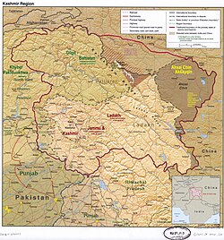
Aksai Chin is one of the two large disputed border areas between India and China. India claims Aksai Chin as the easternmost part of the union territory of Ladakh. China claims that Aksai Chin is part of the Xinjiang Uyghur Autonomous Region and Tibet Autonomous Region. The line that separates Indian-administered areas of Ladakh from Aksai Chin is known as the Line of Actual Control (LAC) and is concurrent with the Chinese Aksai Chin claim line.
Aksai Chin covers an area of approximately 38,000 square kilometres (15,000mi2).[56] The area is largely a vast high-altitude desert with a low point (on the Karakash River) at about 4,300m (14,100ft) above sea level. In the southwest, mountains up to 7,000m (23,000ft) extending southeast from the Depsang Plains form the de facto border (Line of Actual Control) between Aksai Chin and Indian-controlled Kashmir.
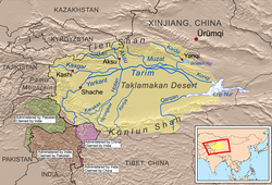
In the north, the Kunlun Range separates Aksai Chin from the Tarim Basin, where the rest of Hotan Prefecture is situated. As of 2008[update], no roads crossed the Kunlun Range within Hotan Prefecture, and only one track does so, over the Hindutash Pass.[57]
Aksai Chin area has number of endorheic basins with many salt or soda lakes. The major salt lakes are Surigh Yilganing Kol, Tso Tang, Aksai Chin Lake, Hongshan Lake, etc. Much of the northern part of Aksai Chin is referred to as the Soda Plains, located near Aksai Chin's largest river, the Karakash, which receives meltwater from a number of glaciers, crosses the Kunlun farther northwest, in Hekang County and enters the Tarim Basin, where it serves as one of the main sources of water for Karakax and Hotan Counties.
The western part of Aksai Chin region is drained by the Tarim River. The eastern part of the region contains several small endorheic basins. The largest of them is that of the Aksai Chin Lake, which is fed by the river of the same name. The region as a whole receives little precipitation as the Himalayas and the Karakoram block the rains from the Indian monsoon.
Prior to 1950, the visitors of Aksai Chin were, for the most part, the occasional explorers, hunters, and nomads who passed through the area.[59][60][61][62]
Prior to European exploration in the 1860s, there were some jade mining operations on the Xinjiang side of Aksai Chin.[61][63] They were abandoned by the time European explorers reached the area.[63] In the 1860s to 1870s, in order to facilitate trade between the Indian subcontinent and Tarim Basin, the British attempted to promote a caravan route via the western side of Aksai Chin as an alternative to the difficult and tariffed Karakoram Pass.[64] The route, referred to as the Chang Chenmo line after the starting point in Chang Chenmo River valley, was discussed in the House of Commons in 1874.[65] In addition of being longer and higher elevation than Karakoram Pass, it also goes through the desolate desert of Aksai Chin.[64][65] By 1890s, traders had mostly given up on this route.[66]
In the 1958, India collected salt from various lakes in Aksai Chin to study the economic feasibility of salt mining operations in the area.[67][68]
In the 2010s, geological surveys were conducted in the Western Kunlun region, which Aksai Chin is part of.[74]Huoshaoyun, a major lead-zinc deposit, and numerous smaller deposits were discovered in the region.[74] Huoshaoyun is a mountain located in Aksai Chin near the Tibetan border.[75] The mining development for Huoshaoyun started in 2017.[76][77]
12 The application of the term "administered" to the various regions of Kashmir and a mention of the Kashmir dispute is supported by the tertiary sources (a) through (e), reflecting due weight in the coverage. Although "controlled" and "held" are also applied neutrally to the names of the disputants or to the regions administered by them, as evidenced in sources (h) through (i) below, "held" is also considered politicized usage, as is the term "occupied," (see (j) below). (a) Kashmir, region Indian subcontinent, Encyclopaedia Britannica, retrieved 15 August 2019 (subscription required) Quote: "Kashmir, region of the northwestern Indian subcontinent ... has been the subject of dispute between India and Pakistan since the partition of the Indian subcontinent in 1947. The northern and western portions are administered by Pakistan and comprise three areas: Azad Kashmir, Gilgit, and Baltistan, the last two being part of a territory called the Northern Areas. Administered by India are the southern and southeastern portions, which constitute the state of Jammu and Kashmir but are slated to be split into two union territories."; (b) Pletcher, Kenneth, Aksai Chin, Plateau Region, Asia, Encyclopaedia Britannica, retrieved 16 August 2019 (subscription required) Quote: "Aksai Chin, Chinese (Pinyin) Aksayqin, portion of the Kashmir region, at the northernmost extent of the Indian subcontinent in south-central Asia. It constitutes nearly all the territory of the Chinese-administered sector of Kashmir that is claimed by India to be part of the Ladakh area of Jammu and Kashmir state."; (c) "Kashmir", Encyclopedia Americana, Scholastic Library Publishing, 2006, p.328, ISBN978-0-7172-0139-6 C. E Bosworth, University of Manchester Quote: "KASHMIR, kash'mer, the northernmost region of the Indian subcontinent, administered partlv by India, partly by Pakistan, and partly by China. The region has been the subject of a bitter dispute between India and Pakistan since they became independent in 1947"; (d) Osmańczyk, Edmund Jan (2003), Encyclopedia of the United Nations and International Agreements: G to M, Taylor & Francis, pp.1191–, ISBN978-0-415-93922-5 Quote: "Jammu and Kashmir: Territory in northwestern India, subject to a dispute between India and Pakistan. It has borders with Pakistan and China." (e) Talbot, Ian (2016), A History of Modern South Asia: Politics, States, Diasporas, Yale University Press, pp.28–29, ISBN978-0-300-19694-8 Quote: "We move from a disputed international border to a dotted line on the map that represents a military border not recognized in international law. The line of control separates the Indian and Pakistani administered areas of the former Princely State of Jammu and Kashmir."; (f) Skutsch, Carl (2015) [2007], "China: Border War with India, 1962", in Ciment, James (ed.), Encyclopedia of Conflicts Since World War II (2nded.), London and New York: Routledge, p.573, ISBN978-0-7656-8005-1, The situation between the two nations was complicated by the 1957–1959 uprising by Tibetans against Chinese rule. Refugees poured across the Indian border, and the Indian public was outraged. Any compromise with China on the border issue became impossible. Similarly, China was offended that India had given political asylum to the Dalai Lama when he fled across the border in March 1959. In late 1959, there were shots fired between border patrols operating along both the ill-defined McMahon Line and in the Aksai Chin. (g) Clary, Christopher (2022), The Difficult Politics of Peace: Rivalry in Modern South Asia, Oxford and New York: Oxford University Press, p.109, ISBN9780197638408, Territorial Dispute: The situation along the Sino-Indian frontier continued to worsen. In late July (1959), an Indian reconnaissance patrol was blocked, "apprehended," and eventually expelled after three weeks in custody at the hands of a larger Chinese force near Khurnak Fort in Aksai Chin. ... Circumstances worsened further in October 1959, when a major class at Kongka Pass in eastern Ladakh led to nine dead and ten captured Indian border personnel, making it by far the most serious Sino-Indian class since India's independence. (h) Bose, Sumantra (2009), Kashmir: Roots of Conflict, Paths to Peace, Harvard University Press, pp.294, 291, 293, ISBN978-0-674-02855-5 Quote: "J&K: Jammu and Kashmir. The former princely state that is the subject of the Kashmir dispute. Besides IJK (Indian-controlled Jammu and Kashmir. The larger and more populous part of the former princely state. It has a population of slightly over 10 million, and comprises three regions: Kashmir Valley, Jammu, and Ladakh.) and AJK ('Azad" (Free) Jammu and Kashmir. The more populous part of Pakistani-controlled J&K, with a population of approximately 2.5 million.), it includes the sparsely populated "Northern Areas" of Gilgit and Baltistan, remote mountainous regions which are directly administered, unlike AJK, by the Pakistani central authorities, and some high-altitude uninhabitable tracts under Chinese control." (i) Fisher, Michael H. (2018), An Environmental History of India: From Earliest Times to the Twenty-First Century, Cambridge University Press, p.166, ISBN978-1-107-11162-2 Quote: "Kashmir’s identity remains hotly disputed with a UN-supervised “Line of Control” still separating Pakistani-held Azad (“Free”) Kashmir from Indian-held Kashmir."; (j) Snedden, Christopher (2015), Understanding Kashmir and Kashmiris, Oxford University Press, p.10, ISBN978-1-84904-621-3 Quote:"Some politicised terms also are used to describe parts of J&K. These terms include the words 'occupied' and 'held'."
↑Pletcher, Kenneth. "Aksai Chin | History, Conflict, & Map". Encyclopædia Britannica. Encyclopædia Britannica, Inc. Retrieved 24 July 2025. Aksai Chin, portion of the Kashmir region, at the northernmost extent of the Indian subcontinent in south-central Asia. It constitutes nearly all the territory of the Chinese-administered sector of Kashmir that is claimed by India to be part of Ladakh union territory.
12Naval War College Review. Naval War College. 1966. p.98. During these same months, the route across the portion of Ladakh known as Aksai Chin (white stone desert) is highly traversable.
12Zhou Enlai (Chou En-Lai) (15 November 1962). 国务院总理周恩来就中印边界問題致亚非国家領导人的信(PDF). 中华人民共和国国务院公报 (Bulletin of the State Council of PRC) (in Chinese): 228. Archived(PDF) from the original on 13 June 2015. Retrieved 30 December 2019– via 中华人民共和国中央人民政府门户网站. 在西段,印度政府提出爭議的传统习惯綫以东和以北的地区,历来是屬于中国的。这个地区主要包括中国新疆所屬的阿克賽欽地区和西藏阿里地区的一部分,面积共为三万三千平方公里,相当于一个比利时或三个黎巴嫩。这个地区虽然人烟稀少,却历来是联結新疆和西藏阿里的交通命脉。新疆的柯尔克孜族和維吾尔族的牧民經常在这一带放牧。阿克賽欽这个地名就是維吾尔語"中国的白石滩"的意思。这块地方一直到現在是在中国的管轄之下。
↑Geeta Kochhar (19 March 2018). China's Foreign Relations and Security Dimensions. Taylor & Francis. pp.40–. ISBN978-0-429-01748-3. The etymology of Aksai Chin is uncertain. Although 'Aksai' is a Turk term for 'white brooks', it is widely believed that the word 'chin' has nothing to do with China.
12Harish Kapadia (March 2002). High Himalaya Unknown Valleys. Indus Publishing. p.309. ISBN978-81-7387-117-7. Aksai Chin, (Aksai: eastern, Chin: China) ... Most of the names were found to be distinctly Yarkandi.
↑"ئاقساي چىنمۇ ياكى ئاقساي چۆلمۇ؟"[Is Aksai True or Aksai Desert?] (in Uyghur). Radio Free Asia. 22 June 2010. Archived from the original on 5 September 2010. Retrieved 18 January 2020. ماقالە يازغۇچى داۋاملاشتۇرۇپ: بۇ تېررىتورىيىنىڭ نامى تۈرك تىلىدا، "ئاقساي چىن " دېيىلىدۇ، بۇ ئىسىمدىكى "چىن" سۆزى جۇڭگونى كۆرسىتىدۇ، ئېيتىشلارغا ئاساسلانغاندا، بۇ سۆزنىڭ مەنىسى – " جۇڭگونىڭ ئاق تاشلىق جىلغىسى ياكى جۇڭگونىڭ ئاق تاشلىق سېيى" دېگەنلىك بولىدۇ دەيدۇ. [The author goes on to say that the name of the territory is in Turkish, "Aksai Chin", and the word "Chin" in that name means China, and it is said that the word means "White Valley of China or China's White River".]
↑Mehra, An "agreed" frontier (1992), p.79: "The name 'Aksai Chin' occurred on a map captioned 'Rough sketch of caravan routes through the Pamir steppes and Yarkand, from information collected' from Mahomed Ameen Yarkandi [Mohammed Amin], 'late guide' to the well-known Schlagintweit brothers. This was compiled in the Quartermaster-General's office in 1862. The sketch, which offered no details this side of the Kunlun, had 'Aksai Chin' written right across the blank space south of the Kunlun range. Mahomed Ameen had noted that 'beyond the pass (north of the Chang Chenmo) lies the Aksai Chin. ... it extends to Chinese territory to the East.'"
↑Brescius, Moritz von (2019), German Science in the Age of Empire, Cambridge University Press, pp.197–199 (including Map 5.2: 'Rough Sketch of Caravan Routes through the Pamir Steppes and Yarkund, from Information Collected from Mahomed Ameen Yarkundi, Late Guide to Messrs. De Schlagintweit'), ISBN978-1-108-42732-6
1234567Maxwell, Neville (1970). India's China War. New York: Pantheon. p.3. Archived from the original on 1 November 2013. Retrieved 4 January 2020. At 17,000 feet elevation, the desolation of Aksai Chin had no human importance other than an ancient trade route that crossed over it, providing a brief pass during summer for caravans of yaks from Sinkiang to Tibet that carried silk, jade, hemp, salt
↑Gaver, John W. (2011). Protracted Contest: Sino-Indian Rivalry in the Twentieth Century. University of Washington Press. p.83. ISBN978-0295801209. Retrieved 4 January 2020. The westerly route via Aksai Chin was an old caravan route and in many ways the best. It was the only route that was open year-round, throughout both the winter and the monsoon season. The Dzungar army that had reached Lhasa in 1717 ... had followed this route.
↑The Sino-Indian Border Disputes, by Alfred P. Rubin, The International and Comparative Law Quarterly, Vol. 9, No. 1. (Jan. 1960), pp. 96–125, JSTOR756256.
↑Younghusband, Francis E. (1896). The Heart of a Continent. John Murray, London. Facsimile reprint: (2005) Elbiron Classics, pp. 223–224.
↑Grenard, Fernand (1904). Tibet: The Country and its Inhabitants. Fernand Grenard. Translated by A. Teixeira de Mattos. Originally published by Hutchison and Co., London. 1904. Reprint: Cosmo Publications. Delhi. 1974, pp. 28–30.
12Noorani, A.G. (30 August – 12 September 2003), "Fact of History", Frontline, vol.26, no.18, Madras: The Hindu group, archived from the original on 2 October 2011, retrieved 24 August 2011
↑Woodman 1969, p.102: The proposed boundary seems never to have been considered in the same form again until Alastair Lamb revived it in 1964
12Verma, Virendra Sahai (2006). "Sino-Indian Border Dispute at Aksai Chin – A Middle Path For Resolution". Journal of Development Alternatives and Area Studies. 25 (3): 6–8. ISSN1651-9728.
12費風 (11 May 2020). 中印邊境再爆衝突 150士兵毆鬥釀12傷. Hong Kong Economic Times (in Traditional Chinese). Retrieved 16 May 2020. 消息指,第一起事件發生於5月5日至6日,在中印邊境的班公錯湖(Pangong Tso )地區,當時解放軍的「侵略性巡邏」(aggressive patrolling)被印度軍方阻攔。「結果發生了混亂,雙方都有一些士兵受傷。」{...}2017年8月,兩國軍隊曾於拉達克地區班公湖附近爆發衝突,當時雙方擲石攻擊對方,雙方均有人受傷,最終兩軍在半小時後退回各自據點。
↑"Aksai Chin". Britannica. 2013. Retrieved 11 June 2021. At the conclusion of the conflict, China retained control of about 14,700 square miles (38,000 square km) of territory in Aksai Chin.
↑Xinjiang Uyghur Autonomous Region Road Atlas (中国分省公路丛书:新疆维吾尔自治区), published by 星球地图出版社 Xingqiu Ditu Chubanshe, 2008, ISBN978-7-80212-469-1. Map of Hotan Prefecture, pp. 18–19.
↑W.F. Van Eekelen (11 December 2013). Indian Foreign Policy and the Border Dispute with China. Springer. ISBN9789401765558. Retrieved 13 December 2019. Neither party exercised a great extent of administration in Aksai Chin, but the occasional explorer, big-game hunter or nomad from India may be sufficient to establish continuity of title.
12Steven A. Hoffmann (20 April 2018). India and the China Crisis. Univ of California Press. p.12. ISBN978-0-520-30172-6. There was jade mining from the Sinkiang side, and some ancient (if secondary) trade routes crossed it. But that was all
↑Lamb, Alastair (1964). The China-India Border: The Origins of the Disputed Boundaries. Chatham House Online Archive. Oxford University Press. p.112. From 1927 to 1950, of course, Aksai Chin was a region of absolutely absolutely no importance. [...] no one visited it except the occasional explorer, big-game hunter and nomad.
12Robert Shaw (1871). Visits to High Tartary, Yârkand, and Kâshgar (formerly Chinese Tartary): And Return Journey Over the Karakoram Pass. J. Murray. p.98. [Oct 29] beginning of the soda-plain [Oct 30] Karakash River [Nov 3] At a corner on the south side there is a piece of path with a bit of wall built up to support it, and yesterday we passed a group of stone huts: all signs that this road was once in use. (We found afterwards that this valley had formerly been frequented by the Chinese, who objected jade from hence. This industry is now extinct, as the Mussulmans of Tookistan have no taste for ornaments of this stone.) [Nov 5] plains full of salt craters
12Harish Kohli (2000). Across the Frozen Himalaya: The Epic Winter Ski Traverse from Karakoram to Lipu Lekh. Indus Publishing. pp.86–87. ISBN978-81-7387-106-1. the five difficult passes through the Karakorams posed a barrier ... Cayley reconnoitred a route that went through the Changchenmo ranges ... if anything these new passes were higher than the ones they replaced, and the land in between them was also higher. ... The route had another advantage in that trade from British India could flow through Kulu via Changchenmo to Yarkand, completely bypassing the customs officials of the Maharaja at Leh.
12Accounts and Papers. East India. Vol.XLIX. House of Commons, British Parliament. 1874. pp.23–33. (p26) The Changchenmo line ... The extra distance and the sojourn for 5 days longer in such a desolate tract (p33) Every endeavour has been made to improve the Changchenmo route—serais having been built at some places, and depots of grain established as far as Gogra
↑A. E. Ward (1896). The Tourist's And—sportsman's Guide to Kashmir and Ladak, &c. Thacker, Spink. pp.106–107. Joining the left bank of the river opposite to Kyam are the Silung Yokma, Silung Burma and Silung Kongma. ... cross the Changchenmo valley journey up the Kiepsang stream ... The traders have now almost entirely given up the Changchenmo-Shahidula route to Yarkand.
↑Council of Scientific & Industrial Research (India) (1958). Technical Report. p.127. Brines from (i) Pong Kong, (ii) Sarigh Jilgang Kol and (iii) Amtogor lakes were examined for their suitability for salt manufacture. The brines from the first two sources have been found to be uneconomical for salt manufacture.
↑"在海拔5070米的空喀山口哨卡某边防团政委宗建明和官兵深情的拥抱"[Zong Jianming, political commissar of a border defense regiment, and the officers and soldiers at the empty Kazan checkpoint at an altitude of 5,070 meters affectionately embrace]. Sina Military. 17 September 2009. Archived from the original on 14 December 2019. Retrieved 14 December 2019.
↑颜玮珏 (30 September 2013). 马丹宁 (ed.). "Keeping watch over highest mountain". China Daily. Archived from the original on 29 December 2019. Retrieved 29 December 2019. Soldiers pose for a picture at the Heweitan sentry post on Karakorum Mountains in Xinjiang Uygur autonomous region, Sept 30.
↑陈金财; 徐俊 (7 December 2016). 杜麒麟; 孙和静 (eds.). "走进天路兵站甜水海 体会官兵生活的苦与乐"[Enter the army outpost Tianshuihai on the skyward road, experience the hardship and joy of army life]. 中国陆军网[China Army Net] (in Chinese). People's Liberation Army News and Dissemination Center. Archived from the original on 13 December 2019. Retrieved 13 December 2019. 从1959年建站起,兵站所有的生活用水,都要到90公里外的"死人沟"泉水湖去拉,来回一趟至少6个小时,如果到了冬季,还得破冰取水。[Since the establishment of the station in 1959, all domestic water in the military depot has to be pulled from the "Deadrengou" spring lake 90 kilometers away. It takes at least six hours to go back and forth. If it is winter, the ice must be broken for water.]
↑罗俊, ed. (18 November 2011). "新疆死人沟——窒息的环境 惊险的美"[Death Valley in Xinjiang-a suffocating environment, breathtaking beauty] (in Chinese). People's Daily Oversea Edition. Archived from the original on 21 January 2013. Retrieved 13 December 2019. 死人沟只有五顶帐篷,能为过往行人提供简单的饭菜面食。对面有一个兵站。[There are only five tents in the Dead Valley, which can provide simple meals and pasta for the passersby. There is a military station opposite.]
12张作衡 (September 2017). "2017年矿产资源地质调查新进展"[New progress in geological survey of mineral resources in 2017](PDF) (in Chinese). China Geological Survey. p.27. Archived(PDF) from the original on 25 January 2020. Retrieved 16 January 2020. 新疆西昆仑地区铅锌找矿取得一批新发现...火烧云铅锌矿已提交333以上铅锌资源储量1704万吨...调查发现多宝山、萨岔口、团结峰、甜水海、鸡冠石、天柱山等10余处中小型矿床 [A number of new discoveries have been made in lead-zinc prospecting in the West Kunlun area of Xinjiang... The Huoshaoyun lead-zinc deposit has submitted a lead-zinc resource reserve of more than 333 million tons... Tianzhushan and more than ten small and medium-sized deposits]
↑Ma, Echo (24 February 2017). "Development starts on China's largest lead-zinc mine". Fastmarkets. Metal Bulletin. Archived from the original on 28 December 2019. Retrieved 28 December 2019. The Huoshaoyun lead-zinc mine site in Xinjiang province, 5,500 metres above sea level, is reported to contain about 19 million tonnes of lead and zinc, with an average grade of 30%, according to the China Geological Survey. It will be the world's seventh-largest lead-zinc mine.
Look up Aksai Chin in Wiktionary, the free dictionary.
China and Kashmir, by Jabin T. Jacob, published in The Future of Kashmir, special issue of ACDIS Swords and Ploughshares, Program in Arms Control, Disarmament, and International Security, University of Illinois, winter 2007–8.
This page is based on this Wikipedia article Text is available under the CC BY-SA 4.0 license; additional terms may apply. Images, videos and audio are available under their respective licenses.