Ningxia,[a] officially the Ningxia Hui Autonomous Region,is an autonomous region in Northwestern China. Formerly a province,Ningxia was incorporated into Gansu in 1954 but was later separated from Gansu in 1958 and reconstituted as an autonomous region for the Hui people,one of the 56 officially recognised nationalities of China. Twenty percent of China's Hui population lives in Ningxia.[7]
Ningxia is bounded by Shaanxi to the east,Gansu to the south and west and Inner Mongolia Autonomous Region to the north and has an area of around 66,400 square kilometres (25,600sqmi).[1] This sparsely settled,mostly desert region lies partially on the Loess Plateau and in the vast plain of the Yellow River and features the Great Wall of China along its northeastern boundary. Over about 2000 years,an extensive system of canals (with a total length of approximately 1397 kilometers)[8] has been built from Qin dynasty. Extensive land reclamation and irrigation projects have made increased cultivation possible. The arid region of Xihaigu,which covers large parts of the province,suffers from severe water shortage,which the canals were intended to alleviate.[9]
Ningxia was the core area of the Western Xia in the 11th–13th centuries,established by the Tangut people;its name,"Peaceful Xia",derived from the Mongol conquest of the state.[10] The Tanguts made significant achievements in literature,art,music,and architecture,and in particular,invented Tangut script. Long one of the country's poorest areas,a small winemaking industry has become economically important since the 1980s. Before the arrival of viticulture,Ningxia's 6.8million people,36 per cent of whom are Muslims from the Hui ethnic group,relied largely on animal grazing,subsistence agriculture and the cultivation of wolfberries used in traditional Chinese medicine. Since then,winemaking has become the premier specialty of Ningxia,and the province devotes almost 40,000 hectares to vineyards and producing 120 million bottles of wine in 2017 –a quarter of the entire nation's production.[11]
History
The earliest human activity in Ningxia can be traced back to 30,000 years ago,with remains of the Shuidonggou culture found in Lingwu.[12]
As a frontier zone between nomadic pastoralists and sedentary farmers,Ningxia was a frequent seat of war and incursions by non-Chinese tribes. Ningxia and its surrounding areas were incorporated into the Qin as the Beidi Commandery as early as the 3rd century BC. To pacify the region,the imperial government established military colonies to reclaim land. In addition,horse pasturages were founded under the Imperial Stud to safeguard the supply of army horses,as early as the Western Han dynasty (206 BC –AD 9).[13] Throughout the Han dynasty and the Tang dynasty there were several large cities established in the region. The Liang Province rebellion at the end of the Han dynasty affected Ningxia.
It then came under Mongol domination after Genghis Khan conquered Yinchuan in the early 13th century. Muslims from Central Asia also began moving into Ningxia from the west. By the late 17th century,Ningxia had become a weaving centre,producing many early Chinese carpets.[15] The Muslim Dungan Revolt of the 19th century affected Ningxia.
From 1950 to 1958,a Kuomintang Islamic insurgency resulted in fighting throughout Northwest China,including Ningxia. In 1954,the Chinese government merged Ningxia with Gansu,but in 1958 Ningxia formally became an autonomous region of China. In 1969,Ningxia received a part of the Inner Mongolian Autonomous Region,but this area was returned in 1979.
A number of Chinese artifacts dating from the Tang dynasty and Song dynasty,some of which had been owned by Emperor Zhenzong,were excavated and then came into the hands of Ma Hongkui,who refused to publicize the findings. Among the artifacts were a white marble tablet from the Tang dynasty,gold nails,and bands made out of metal. It was not until after Ma Hongkui died that his wife went to Taiwan in 1971 from America to bring the artifacts to Chiang Kai-shek,who turned them over to the TaipeiNational Palace Museum.[17]
Present-day Ningxia is one of the nation's smallest provincial-level units and borders the provinces of Shaanxi and Gansu and the Inner Mongolia Autonomous Region. At 3556 meters above sea level,Aobaogeda (敖包疙瘩) in the Helan Mountains is the highest point in Ningxia.[18]
Ningxia is a relatively dry,desert-like region and features a diverse geography of forested mountains and hills,table lands,deserts,flood plains and basins cut through by the Yellow River. The Ningxia ecosystem is one of the least studied regions in the world. Significant irrigation supports the growing of wolfberries,a commonly consumed fruit throughout the region. Ningxia's deserts include the Tengger desert in Shapotou.
The northern section,through which the Yellow River flows,supports the best agricultural land. A railroad,linking Lanzhou with Baotou,crosses the region. A highway has been built across the Yellow River at Yinchuan.
It was reported that approximately 34 percent (33.85million mu; 22,600km2) of the region's total surface consisted of grassland.[21] This figure is down from approximately 40 percent in the 1990s. The grasslands are spread over the dry desert-steppe area in the northeast (which forms a part of the Inner Mongolian steppe region), and the hilly pastures located on the semi-arid Loess Plateau in the south.[22] It is ascertained that the grasslands of Ningxia have been degraded to various degrees.[23] Scientists debate the extent to which this degradation occurs over space and time.[24] Historical research has also found limited evidence of expanding grassland degradation and desertification in Ningxia.[13][25] A major component of land management in Ningxia is a ban on open grazing, which has been in place since 2003.[26] The ecological and socio-economic effects of this Grazing Ban in relation to the grasslands and pastoralists' livelihood are contested.[22] The ban stipulates that animal husbandry be limited to enclosed pens and no open grazing be permitted in certain time periods set by the Autonomous Region's People's Government.
The region is 1,200 kilometres (750mi) from the sea and has an arid continental climate on the north to humid continental climate to the south, with average summer temperatures rising to 17 to 24°C (63 to 75°F) in July and average winter temperatures dropping to between −7 and −15°C (19 and 5°F) in January. Seasonal extreme temperatures can reach 39°C (102°F) in summer and −30°C (−22°F) in winter. The diurnal temperature variation can reach above 17°C (31°F), especially in spring. Annual rainfall averages from 190 to 700 millimetres (7.5 to 27.6in), with more rain falling in the south of the region.
Mineral resources
Ningxia is rich in mineral resources with proven deposits of 34 kinds of minerals, much of which located in grassland areas.[22] In 2011 it was estimated that the potential value per capita of these resources accounted for 163.5 percent of the nation's average. Ningxia boasts verified coal reserves of over 30billion tons, with an estimated reserve of more than 202billion tons, ranking sixth nationwide. Coal deposits are spread over one-third of the total surface of Ningxia, and mined in four major fields in the Helan and Xiangshan mountains, Ningdong and Yuanzhou (or Guyuan). The region's reserves of oil and natural gas can be found in Yanchi and Lingwu County, and are ideal for large-scale development of oil, natural gas and chemical industries. Ningxia leads China in gypsum deposits, with a proven reserve of more than 4.5billion tons, of which the rarely found, top-grade gypsum accounts for half of the total deposits. The Hejiakouzi deposit in Tongxin County features a reserve of 20million tons of gypsum with a total thickness of 100 meters. There is a considerable deposit of quartz sandstone, of which 17million tons have been ascertained. In addition, there are phosphorus, flint, copper, iron, barite, other minerals and Helan stone – a special clay stone.[10][28]
Rural Ningxia was for long an officially designated poverty area, and remains on the lower rungs of the developmental ladder.[22] Its nominal GDP in 2023 was 531.50billion yuan (US$75.43billion) and its per capita GDP 72,957 yuan (US$10,353). It comprises 0.42% of the national economy.
Agriculture
Similar to other areas, Ningxia has seen a gradual decline of its peasant population due to rural–urban migration. Despite this, the great majority (62.8 percent) was still agricultural at the time of the survey.[37] Animal husbandry is important for the regional economy. In the main pastoral county, Yanchi, it is even the leading industry when specified for the primary sector. The dominant grazing animals are sheep and goat.[38] In the (semi-)pastoral regions, herders engage in a mixed sedentary farming operation of dryland agriculture and extensive animal husbandry, while full nomadic pastoralism is no longer practiced.[22] Since a cattle breeding plan was implemented in 2002, the province has become one of China's main dairy production areas.[39][40]
Ningxia is the principal region of China where wolfberries are grown. Other specialties of Ningxia are licorice, products made from Helan stone, fiddlehead and products made from sheepskin.
Ningxia wines are a promising area of development. The Chinese authorities have given approval to the development of the eastern base of the Helan Mountains as an area suitable for wine production. Several large Chinese wine companies including Changyu and Dynasty Wine have begun development in the western region of the province. Together they now own 20,000 acres of land for wine plantations and Dynasty has ploughed 100 million yuan into Ningxia. In addition, the major oil company China Petroleum and Chemical Corporation has founded a grape plantation near the Helan Mountains. The household appliance company Midea has also begun participating in Ningxia's wine industry.[41] Vineyards have been set up in the region.[42]
Industries and economic zones
Ningxia was a major recipient of China's investment in industrial capacity during the Third Front campaign.[43]:298
YinchuanEconomic and Technological Development Zone[44] was established in 1992. Spanning 32km2 (12sqmi), it has an annual economic output Rmb23.7billion (25.1% up) (US$3.5billion). Major investors are mainly local enterprises such as Kocel Steel Foundry, FAG Railway Bearing (Ningxia), Ningxia Little Giant Machine Tools, etc. Major industries include machinery and equipment manufacturing, new materials, fine chemicals and the animation industry.
Desheng Industrial Park (in Helan County) is a base for about 400 enterprises. The industrial park has industrial chains from Muslim food and commodities to trade and logistics, new materials and bio-pharmaceuticals that has 80billion yuan in fixed assets. Desheng is looking to be the most promising industrial park in the city. It achieved a total output value of 4.85billion in 2008, up 40 percent year-on-year. The local government plans to cut taxes and other fees to reduce the burden on local enterprises. The industrial output value reached 2.68billion yuan in 2008, an increase of 48 percent from a year earlier.
In 2008, there were 3,760 mosques in Ningxia, which is about one per 1730 residents.[56]
Hospitals
People's Hospital of Ningxia
Hospital of Traditional Chinese Medicine of Ningxia
Ningxia Medical College Affiliated Hospital
Yinchuan Hospital of Traditional Chinese Medicine
Yinchuan People's Hospital
Yinchuan Stomatological Hospital
Yinchuan Women and Children's Healthcare Center
Women and Children's Healthcare Center of Ningixa
Yinchuan No.1 People's Hospital
Yinchuan No.2 People's Hospital
Yinchuan No.3 People's Hospital
Shizuishan No.2 People's Hospital
Guyuan Hospital of Ningxia
Tourism
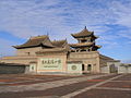
One of Ningxia's main tourist spots is the internationally renowned Xixia Tombs site located 30km (19mi) west of Yinchuan. The remnants of nine Western Xia emperors' tombs and two hundred other tombs lie within a 50km2 (19sqmi) area. Other famous sites in Ningxia include the Helan Mountains, the mysterious 108 stupas, the twin pagodas of Baisikou and the desert research outpost at Shapotou. A less visited tourist spot in Ningxia is the Mount Sumeru Grottoes (须弥山), which is among the ten most famous grottoes in China.[57]
↑宁夏回族自治区资源概况[Overview of Resources in Ningxia Hui Autonomous Region]. Zhōngguó wǎng (in Chinese). 17 December 2009. Archived from the original on 4 August 2020. Retrieved 2 October 2018.
12Ho, Peter (2000). "The Myth of Desertification at China's Northwestern Frontier: The Case of Ningxia Province, 1929–1958". Modern China. 26 (3): 348–395. doi:10.1177/009770040002600304. S2CID83080752.
↑Xu, Xin (2003). The Jews of Kaifeng: China History, Culture, and Religion. Jersey City, NJ: Ktav Publishing House.
↑Close, U.; McCormick (1922). "Where the Mountains Walked". National Geographic Magazine. Vol.41, no.5. pp.445–464.
↑Feng, X.; Guo, A. (1985). "Earthquake Landslides in China". Proceedings, IVth International Conference and Field Workshop on Landslides. Tokyo: Japan Landslide Society. pp.339–346.. (1985) "
12345Ho, Peter (2016). "Empty Institutions, Non-Credibility and Pastoralism: China's Grazing Ban, Mining and Ethnicity". The Journal of Peasant Studies. 43 (6): 1145–1176. doi:10.1080/03066150.2016.1239617. S2CID157632052.
↑Ho, P. (2001). "Rangeland Degradation in North China Revisited? A Preliminary Statistical Analysis to Validate Non-Equilibrium Range Ecology". The Journal of Development Studies. 37 (3): 99–133. doi:10.1080/00220380412331321991. S2CID154397243.
↑Ho, Peter (2003). "Mao's War against Nature? The Environmental Impact of the Grain-First Campaign in China". The China Journal. 50 (50): 37–59. doi:10.2307/3182245. JSTOR3182245. S2CID144410824.
↑Zhou, Z. 2013. A view of Ningxia ten years since the grazing ban [Jìn mù yī nián kàn Níngxià]. People's Daily, 29 June. p. 10.
↑Lawrence, Susan; Martin, Michael (20 March 2013). "Understanding China's Political System"(PDF). Federation of American Scientists. Congressional Research Service. Archived(PDF) from the original on 8 January 2012. Retrieved 28 September 2019.
↑党委书记权力究竟有多大?[How much power does a Party Secretary really have?]. 人民论坛 (in Chinese (China)). People's Daily Press. 23 January 2007. Archived from the original on 2 July 2018. Retrieved 29 April 2018.
↑Census Office of the State Council of the People's Republic of China; Population and Employment Statistics Division of the National Bureau of Statistics of the People's Republic of China (2012). Zhōngguó 2010 rénkǒu pǔchá fēn xiāng, zhèn, jiēdào zīliào中国2010人口普查分乡、镇、街道资料 (1ed.). Beijing: China Statistics Print. ISBN978-7-5037-6660-2.
12Min Junqing. The Present Situation and Characteristics of Contemporary Islam in China. JISMOR, 8. 2010 Islam by province, page 29. Data from: Yang Zongde, Study on Current Muslim Population in China, Jinan Muslim, 2, 2010.
This page is based on this Wikipedia article Text is available under the CC BY-SA 4.0 license; additional terms may apply. Images, videos and audio are available under their respective licenses.