Land reclamation, often known as reclamation, and also known as land fill (not to be confused with a waste landfill), is the process of creating new land from oceans, seas, riverbeds or lake beds. The land reclaimed is known as reclamation ground, reclaimed land, or land fill. The term "reclamation" is a misnomer, and promotes confusion with land rehabilitation.
In ancient Egypt, the rulers of the Twelfth Dynasty (c. 2000–1800 BC) undertook a far-sighted land reclamation scheme to increase agricultural output. They constructed levees and canals to connect the Faiyum with the Bahr Yussef waterway, diverting water that would have flowed into Lake Moeris and causing gradual evaporation around the lake's edges, creating new farmland from the reclaimed land.[1] A similar land reclamation system using dams and drainage canals was used in the Greek Copaic Basin during the Middle Helladic Period (c. 1900–1600 BC).[1] Another early large-scale project was the Beemster Polder in the Netherlands, adding 70 square kilometres (27sqmi) of land in 1612. In Hong Kong, the Praya Reclamation Scheme added 20 to 24 hectares (50 to 60 acres) of land in 1890 during the second phase of construction. It was one of the most ambitious projects undertaken during the era of colonial Hong Kong.[2] Some 20% of land in the Tokyo Bay area has been reclaimed,[3] most notably Odaiba artificial island. The city of Rio de Janeiro was largely built on reclaimed land, as was Wellington, New Zealand. During the 18th and 19th centuries The Seven Islands of Bombay (now Mumbai) were joined with the help of several land reclamation projects like Hornby Vellard and Colaba Causeway
Methods
Land reclamation can be achieved by a number of different methods. The simplest method involves filling the area with large amounts of heavy rock and/or cement, then filling with clay and dirt until the desired height is reached. The process is called "infilling"[4] and the material used to fill the space is generally called "infill".[5][6] Draining of submerged wetlands is often used to reclaim land for agricultural use. Deep cement mixing is used typically in situations in which the material displaced by either dredging or draining may be contaminated and hence needs to be contained. Land dredging is also another method of land reclamation. It is the removal of sediments and debris from the bottom of a body of water. It is commonly used for maintaining reclaimed land masses as sedimentation, a natural process, fills channels and harbors.[7]
The shore of Jakarta Bay. Land is usually reclaimed to create new housing areas and real estate properties, for the rapidly expanding city of Jakarta. So far, the largest reclamation project in the city is the creation of Golf Island, north of Pantai Indah Kapuk.[11]
Forest City, an integrated residential and tourism district in Johor, Malaysia, was controversial due to its reclamation of wetlands of international importance under the Ramsar Convention in a designated Environmentally Sensitive Area (ESA) Rank 1 area.
Reclaimed coastal area in Coron, Palawan, Philippines. The bare, brown-colored reclaimed land stands out from the original vegetated coastside, as seen from atop Mt. Tapyas.
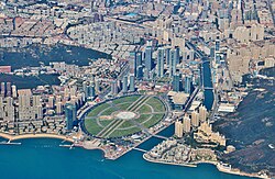
The city-state of Singapore, where land is in short supply, is also famous for its efforts on land reclamation.[13]
The size of Singapore has increased by 25% from 581.5 square kilometres in 1960 to 725.7 in 2019. This is part of the nation's plans to create more homes and common spaces in the land-scarce city-state. Upcoming projects include the Long Island project, involving the reclamation of three tracts of land (expected to span around 800 ha), which is set at a higher level to protect against rising sea levels. It will also enclose a body of water, acting as a reservoir, strengthening the nation's water resilience. Detailed technical studies are currently under way, lasting five years. This project would take a few decades to plan and implement.[14][15]
Considerable areas of Dunedin, New Zealand, including the "Southern Endowment", stretching from the central city to the southeastern suburbs along the shore of Otago Harbour.
Prior to the Napier earthquake of 1931, significant reclamation of the then-lagoon was undertaken in areas of Napier South and Ahuriri. There were also minor reclamation works undertaken after 1931 on the new low-lying lands brought up by the earthquake.
Areas around Wellington and Auckland's harbours and airports have also been reclaimed.
A related practice is the draining of swampy or seasonally submerged wetlands to convert them to farmland. While this does not create new land exactly, it allows commercially productive use of land that would otherwise be restricted to wildlifehabitat. It is also an important method of mosquito control.
Even in the post-industrial age, there have been land reclamation projects intended for increasing available agricultural land. For example, the village of Ogata in Akita, Japan, was established on land reclaimed from Lake Hachirōgata (Japan's second largest lake at the time) starting in 1957. By 1977, the amount of land reclaimed totalled 172.03 square kilometres (66.42sqmi).[28]
Beach rebuilding is the process of repairing beaches using materials such as sand or mud from inland. This can be used to build up beaches suffering from beach starvation or erosion from longshore drift. It stops the movement of the original beach material through longshore drift and retains a natural look to the beach. Although it is not a long-lasting solution, it is cheap compared to other types of coastal defences. An example of this is the city of Mumbai.[10]
Landfill
As human overcrowding of developed areas intensified during the 20th century, it has become important to develop land re-use strategies for completed landfills. Some of the most common usages are for parks, golf courses and other sports fields. Increasingly, however, office buildings and industrial uses are made on a completed landfill. In these latter uses, methane capture is customarily carried out to minimize explosive hazard within the building.
Another strategy for landfill is the incineration of landfill trash at high temperature via the plasma-arc gasification process, which is currently used at two facilities in Japan, and was proposed to be used at a facility in St. Lucie County, Florida.[30] The planned facility in Florida was later canceled.[31]
Environmental impact
Parts (highlighted in brown) of the San Francisco Bay were reclaimed from wetlands for urban use.
Draining wetlands for ploughing, for example, is a form of habitat destruction. In some parts of the world, new reclamation projects are restricted or no longer allowed, due to environmental protection laws. Reclamation projects have strong negative impacts on coastal populations, although some species can take advantage of the newly created area.[32] A 2022 global analysis estimated that 39% of losses (approximately 5,300km2 or 2,000mi2) and 14% of gains (approximately 1,300km2 or 500mi2) of tidal wetlands (mangroves, tidal flats, and tidal marshes) between 1999 and 2019 were due to direct human activities, including conversion to aquaculture, agriculture, plantations, coastal developments and other physical structures.[33]
Environmental legislation
A map of reclaimed land (grey area) in Hong Kong. Many of the urban areas of Hong Kong are on reclaimed land.
Reclaimed land is highly susceptible to soil liquefaction during earthquakes,[35] which can amplify the amount of damage that occurs to buildings and infrastructure. Subsidence is another issue, both from soil compaction on filled land, and also when wetlands are enclosed by levees and drained to create polders. Drained marshes will eventually sink below the surrounding water level, increasing the danger from flooding.
About 110km2 (42sqmi) in total and has 12,000 square kilometres (4,600sqmi) potential (8% of total area) up to 12 metres (39ft) depth in the territorial sea area.[37]
Mumbai – An archipelago of originally seven separate islands were joined by land reclamation over a span of five centuries. This was done to develop Mumbai as a harbour city.
In the 1980s, North Korea commenced a "find new land" program to reclaim 300,000 hectares of land (3,000km2 or 1,160mi2) in order to expand the country's supply of arable land. The project was unsuccessful and only reclaimed 20,000 hectares (200km2 or 70mi2) by the time it was cancelled after the death of Kim Il-sung in 1994. It also contributed to the collapse of the North Korean economy and the subsequent famine in the 1990s. Land reclamation efforts resumed in the 2010s under Kim Jong-un with more success. North Korea constructed artificial islands in the Yellow Sea containing Korean People's Army bases, possibly inspired by Chinese artificial islands in the South China Sea and possibly as bases for long-range ballistic missiles.[43][44][45]
Cebu South Road Properties, Cebu City, Philippines - Artificial island which is 300 hectares was built along the sea between Mainland Cebu and Kawit Island. This was done to address the increasing need of urban and residential development in Cebu City due to its very progressive economy.
20 percent of the original size or 135km2 (52sqmi). As of 2003[update], plans for 99km2 (38sqmi) more are to go ahead,[47] even though disputes persist with Malaysia over Singapore's extensive land reclamation works.[48] Parts of Changi Airport are also on reclaimed land.
As of 2006, 38 percent or 1,550km2 (600sqmi) of coastal wetlands reclaimed, including 400km2 (150sqmi) at Saemangeum. Songdo International Business district, the largest private development in history, is a large-scale reclamation project built entirely on tidal mudflats.
0.41km2 (0.16sqmi) out of 2.05km2 (0.79sqmi), or one fifth of Monaco comes from land taken from the sea, mainly in the neighborhoods of Fontvieille, La Condamine, and Larvotto/Bas Moulins.
About 1⁄6 (almost 17%) of the entire country, or about 7,000km2 (2,700sqmi) in total, has been reclaimed from the sea, lakes, marshes and swamps. The province of Flevoland has almost completely been reclaimed from the Zuiderzee.
Significant areas of land totaling several hundred hectares have been reclaimed along the harbourfronts of Auckland, Dunedin, and Wellington. In Dunedin – which in its early days was nicknamed "Mudedin" – around 2.5km2 (0.97sqmi), including much of the inner city and suburbs of Dunedin North, South Dunedin, and Andersons Bay is reclaimed from the Otago Harbour, and a similar area in the suburbs of St Clair and St Kilda is reclaimed swampland. The international airports serving Auckland and Wellington have had significant reclamation for runway use.[49][50]
↑Administration, US Department of Commerce, National Oceanic and Atmospheric. "What is dredging?". oceanservice.noaa.gov. Retrieved 2018-03-19.{{cite web}}: CS1 maint: multiple names: authors list (link)
↑Murray N. J., Clemens R. S., Phinn S. R., Possingham H. P. & Fuller R. A. (2014) Tracking the rapid loss of tidal wetlands in the Yellow Sea. Frontiers in Ecology and the Environment 12, 267–72 doi:10.1890/130260
↑Brian Lander. State Management of River Dikes in Early China: New Sources on the Environmental History of the Central Yangzi Region . T'oung Pao 100.4-5 (2014): 325–362; Mira Mihelich, “Polders and Politics of Land Reclamation in Southeast China during the Northern Sung” (Ph.D. dissertation, Cornell Univ., 1979); Peter Perdue, Exhausting the Earth: State and Peasant in Hunan 1500–1850 (Cambridge, Massachusetts: Harvard University Council on East Asian Studies, 1987); Mei Li 梅莉, Zhang Guoxiong 張國雄, and Yan Changgui 晏昌貴, Lianghu pingyuan kaifa tanyuan 兩湖平原開發探源 (Nanchang: Jiangxi jiaoyu chubanshe, 1995); Shiba Yoshinobu, “Environment versus Water Control: The Case of the Southern Hangzhou Bay Area from the Mid-Tang Through the Qing,” in Sediments of Time: Environment and Society in Chinese History, ed. Mark Elvin and Ts'ui-jung Liu (Cambridge: Cambridge University Press, 1998), 135–64
↑Paul B. Awosika and Marc Papineau, Phase One Environmental Site Assessment, 7000 Marina Boulevard, Brisbane, California, prepared for Argentum International by Certified. Engineering & Testing Company, Boston, Massachusetts, July 15, 1993
↑"Singapore". The World Factbook. CIA. 1 September 2010. section Transnational issues. Retrieved 1 October 2010. disputes persist with Malaysia over […] extensive land reclamation works
↑Omotosho, Jimmy (2013). "New Cities and Real Estate Markets- A focus on the Eko Atlantic City Project". Proceedings of the 13th African Real Estate Society Conference. African Real Estate Society. doi:10.15396/afres2013_109.
This page is based on this Wikipedia article Text is available under the CC BY-SA 4.0 license; additional terms may apply. Images, videos and audio are available under their respective licenses.