
The Lake Washington Ship Canal is a canal that runs through the city of Seattle and connects the fresh water body of Lake Washington to the salt water inland sea of Puget Sound. The Hiram M. Chittenden Locks accommodate the approximately 20-foot (6.1 m) difference in water level between Lake Washington and the sound. The canal runs east–west and connects Union Bay, the Montlake Cut, Portage Bay, Lake Union, the Fremont Cut, Salmon Bay, and Shilshole Bay, which is part of the sound.

The Duwamish River is the name of the lower 12 miles (19 km) of Washington state's Green River. Its industrialized estuary is known as the Duwamish Waterway. Although heavily polluted, it is an important habitat for the wildlife. Important to the Duwamish people, the Duwamish Longhouse and Cultural Center is on the west bank of the river and several parks have indigenous Lushootseed names.

Elliott Bay is a part of the Central Basin region of Puget Sound. It is in the U.S. state of Washington, extending southeastward between West Point in the north and Alki Point in the south. Seattle was founded on this body of water in the 1850s and has since grown to encompass it completely. The waterway it provides to the Pacific Ocean has served as a key element of the city's economy, enabling the Port of Seattle to become one of the busiest ports in the United States.
Longfellow Creek is a stream in the Delridge district of West Seattle, in Seattle, Washington. It runs about 3.38 miles (5.4 km) from Roxhill Park north to the Duwamish West Waterway at Elliott Bay. The Duwamish called the creek "Smelt", denoting smelt fish. The creek was a traditional fishery dating back to the 14th century.

Vigor Shipyards is the current entity operating the former Todd Shipyards after its acquisition in 2011. Todd Shipyards was founded in 1916, which owned and operated shipyards on the West Coast of the United States, East Coast of the United States and the Gulf. Todd Shipyards were a major part of the Emergency Shipbuilding Program for World War II.

Commencement Bay is a bay of Puget Sound in the U.S. state of Washington. The city of Tacoma is located on the bay, with the Port of Tacoma occupying the southeastern end. A line drawn from Point Defiance in the southwest to Browns Point in the northeast serves to mark the generally accepted division between the bay and the open sound. Commencement Bay has become home to one of the most active commercial ports in the world. The Port of Tacoma is the main port facility.
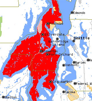
The Kitsap Peninsula lies west of Seattle across Puget Sound, in Washington state in the Pacific Northwest. Hood Canal separates the peninsula from the Olympic Peninsula on its west side. The peninsula, a.k.a. "Kitsap", encompasses all of Kitsap County except Bainbridge and Blake Islands, as well as the northeastern part of Mason County and the northwestern part of Pierce County. The highest point on the Kitsap Peninsula is Gold Mountain. The U.S. Navy's Puget Sound Naval Shipyard, and Naval Base Kitsap are on the peninsula. Its main city is Bremerton.
Raft Island is a private island and CDP located near the Pierce County community of Rosedale, Washington, United States. Gig Harbor, Washington is the nearest incorporated town, although unincorporated Artondale is much closer. The island features approximately 200 homes on 160 acres. All of these homes are served through the Gig Harbor post office.

The Port of Seattle is a public agency that is in King County, Washington. It oversees the seaport of Seattle as well as Seattle–Tacoma International Airport. With a portfolio of properties ranging from parks and waterfront real estate, to one of the largest airports and container terminals on the West Coast, the Port of Seattle is one of the Pacific Northwest's leading economic engines.

Delridge is a district in Seattle, Washington, United States that stretches along Delridge Way, an arterial that follows the eastern slope of the valley of Longfellow Creek, from near its source just within the southern city limits north to the West Seattle Bridge over the Duwamish River. It is generally associated with the neighborhing district of West Seattle, or even considered a sub-district of West Seattle.

The city of Seattle, Washington, is located on a narrow isthmus between Puget Sound on the west and Lake Washington on the east; water comprises approximately 41% of the total area of the city. It was founded on the harbor of Elliott Bay, home to the Port of Seattle—in 2002, the 9th busiest port in the United States by TEUs of container traffic and the 46th busiest in the world.

The Suquamish Indian Tribe of the Port Madison Reservation is a federally recognized tribe and Indian reservation in the U.S. state of Washington.

Smith Cove is a body of water, the northern part of Seattle, Washington's Elliott Bay, immediately south of the area that has been known since 1894 as Interbay. More precisely, it is the part of the bay that lies north of a line running southeasterly from the west end of Elliott Bay Marina in the northwest to the far northwest tip of Myrtle Edwards Park in the southeast.

Lockheed Shipbuilding and Construction Company, was a shipyard in Seattle, Washington with Yard 1 on Harbor Island and Yard 2 at what is now Jack Block Park at Seattle Terminal 5, both at the mouth of the West Waterway of Duwamish River. Yard 1 was founded in 1898 as the Puget Sound Bridge and Dredging Company, the company that built Harbor Island, and it was purchased by Lockheed in 1959. Yard 2 began operation in 1943 to build ships for the US Navy. The shipyard was permanently closed in 1988; Yard 2 was sold in 1989, and Yard 1 was sold in 1997, both to Port of Seattle.
Puget Sound Bridge and Dredging Company was a major shipbuilding and construction company, located in Seattle, Washington, on the southwestern corner of Harbor Island, an artificial island in Elliott Bay. The Bridge and Dredging Company created the island, completing its construction in 1909. It established itself in 1898 and engaged in construction projects around the United States and shipbuilding for the U.S. Navy during and after World War II. During the war it also operated under the name Associated Shipbuilders in a joint venture with the nearby Lake Union Dry Dock Company. In 1959 Lockheed purchased the shipyard and it became the Lockheed Shipbuilding and Construction Company. The Yard was permanently closed in 1987.

The Seattle-Tacoma Shipbuilding Corporation was an American corporation which built escort carriers, destroyers, cargo ships and auxiliaries for the United States Navy and merchant marine during World War II in two yards in Puget Sound, Washington. It was the largest producer of destroyers (45) on the West Coast and the largest producer of escort carriers of various classes (56) of any United States yard active during World War II.
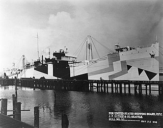
J. F. Duthie & Company was a small shipyard located on the east side of Harbor Island in Seattle, Washington. It was reportedly organized in 1911 and expanded to 4 slipways on 25 acres (10 ha) of property in World War I to build cargo ships for the United Kingdom, France and Norway, but those resources were eventually all diverted at the behest of the United States Shipping Board (USSB). Work on the new plant started on 10 September 1916 and the first keel was laid on 29 November the same year. At that time, the new Skinner & Eddy plant across the water was already launching its first two ships: Niels Nielsen and Hanna Nielsen.

The Puget Sound region is a coastal area of the Pacific Northwest in the U.S. state of Washington, including Puget Sound, the Puget Sound lowlands, and the surrounding region roughly west of the Cascade Range and east of the Olympic Mountains. It is characterized by a complex array of saltwater bays, islands, and peninsulas carved out by prehistoric glaciers.

West Seattle was a side-wheel driven steam-powered ferry built in 1907.

