
Shoreline is a city in King County, Washington, United States. It is located between the city limits of Seattle and the Snohomish County border, approximately 9 miles (14 km) north of Downtown Seattle. As of the 2020 census, the population of Shoreline was 58,608, making it the 22nd largest city in the state. Based on per capita income, one of the more reliable measures of affluence, Shoreline ranks 91st of 522 areas in the state of Washington to be ranked.

Seattle Center is an entertainment, education, tourism and performing arts center located in the Lower Queen Anne neighborhood of Seattle, Washington, United States. Constructed for the 1962 World's Fair, Seattle Center's landmark feature is the 605 ft (184 m) Space Needle, an official city landmark and globally recognized symbol of Seattle's skyline. Other notable attractions include the Pacific Science Center, Climate Pledge Arena, and the Museum of Pop Culture (MoPOP), as well as McCaw Hall, which hosts both the Seattle Opera and Pacific Northwest Ballet. The Seattle Center Monorail provides regular public transit service between Seattle Center and Westlake Center in Downtown Seattle, and is itself considered a tourist attraction.

Windermere is a residential neighborhood in northeastern Seattle, Washington, named after Windermere in England's Lake District. It is bounded on the north by Magnuson Park, part of Sand Point; on the northwest by Sand Point Way N.E., beyond which is Hawthorne Hills; on the southwest by Ivanhoe Place N.E., beyond which is Laurelhurst; and on the southeast by Lake Washington. The area has been a part of Seattle since 1910.

The Ward House is a house on Capitol Hill in Seattle, Washington, USA. Having been built in 1882, it is one of the oldest houses in Seattle. Existing houses reportedly built before 1882 in Seattle include the 2629 East Aloha Street (1881), 727 28th Avenue (1870) and Maynard's House located at 3045 64th Avenue Southwest.
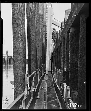
The Alaskan Way Seawall is a seawall which runs for approximately 7,166 feet (2,184 m) along the Elliott Bay waterfront southwest of downtown Seattle from Bay Street to S. Washington Street. The seawall is being rebuilt in the 2010s as part of a waterfront redevelopment megaproject estimated to cost over $1 billion.
Lower Queen Anne is a neighborhood in northwestern Seattle, Washington, at the base of Queen Anne Hill. While its boundaries are not precise, the toponym usually refers to the shopping, office, and residential districts to the north and west of Seattle Center. The neighborhood is connected to Upper Queen Anne—the shopping district at the top of the hill—by an extremely steep section of Queen Anne Avenue N. known as the Counterbalance, in memory of the cable cars that once ran up and down it.

Seattle Children's is a children's hospital in the Laurelhurst neighborhood of Seattle, Washington, United States. The hospital specializes in the care of infants, children, teens, and young adults aged 0–21 in several specialties.

Allentown is a neighborhood of Tukwila, Washington, on the Duwamish River. It is situated between the Rainier View neighborhood of southern Seattle and the Boulevard Park neighborhood of unincorporated King County.

Madison Park is a neighborhood in eastern Seattle, Washington, United States. It is named after the city park at the foot of Madison Street on the Lake Washington shore. The neighborhood is generally bounded on the east by Lake Washington; on the south by East Prospect Street, beyond which is Denny-Blaine; on the west by Lake Washington Boulevard E.; and on the north by Union Bay. Madison Park generally consists of single-family housing with a small business district near the park.
Dunlap is a neighborhood in southern Seattle, Washington, just north of Rainier Beach. It is home to Dunlap Elementary School, part of the Seattle Public Schools. Dunlap is named after Joseph Dunlap, the first homesteader in the area.
Brighton is a primarily residential neighborhood in southern Seattle, Washington, part of the greater Rainier Valley district and centered about a mile and a half south of the Columbia City neighborhood.
Genesee is a neighborhood of West Seattle in Seattle, Washington. It extends north from SW Genesee St. to SW Charlestown St., and west from 46th to 56th Avenues SW. The neighborhood includes Ercolini Park and the new Genesee Hill Elementary School. It should not be confused with Genesee Park, in Rainier Valley.
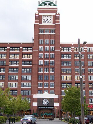
The Starbucks Center is the world headquarters of the coffeehouse chain Starbucks. It is located in the SoDo neighborhood of Seattle, Washington; the area is part of the city's large industrial district. Starbucks Center is the largest multi-tenant building by floor space in Seattle, with over 1.8 million square feet (170,000 m2). It is both the largest and oldest building in the country to earn a national green certification.

Hillman City is a primarily residential neighborhood in southeastern Seattle, Washington, located in the Rainier Valley and centered about a half mile south of the Columbia City neighborhood. It was annexed by Seattle in January 1907, along with the rest of the town of Southeast Seattle.

Beacon Food Forest is a 7-acre food forest in development adjacent to Jefferson Park on Beacon Hill in Seattle, Washington in the vicinity of 15th Avenue South and South Dakota Street. As the area sits on land owned by Seattle Public Utilities, it is believed to be the largest food forest on public land in the United States. The project also has more traditional private allotments, similar to those in other local P-Patch gardens.
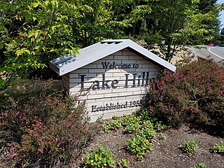
Lake Hills is a neighborhood in Bellevue, Washington. It lies to the south of the Crossroads and north of the Eastgate neighborhoods.

Loyal Heights is a neighborhood in Seattle, Washington. It is considered part of greater Ballard.

The Maynard Building is a five-story office building in Seattle, Washington. Constructed in 1892 on a Romanesque Revival design by Albert Wickersham, the masonry building was originally known as the Dexter Horton Building and housed Dexter Horton's nascent banking business, which eventually grew into Seafirst Bank. Located at 119 First Avenue South in the city's Pioneer Square neighborhood, the building took its current name in honor of Doc Maynard. The Maynard Building underwent a major refurbishment between 1974 and 1975.
West Woodland is a neighborhood in Seattle, Washington. The city's Department of Neighborhoods places West Woodland in the south east corner of Ballard.
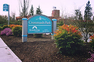
Crossroads is a neighborhood in Bellevue, Washington. It is situated in the north and eastern portion of the city, lying south of Bellevue-Redmond Road, east of Bellevue's Wilburton neighborhood, and north of Lake Hills.
