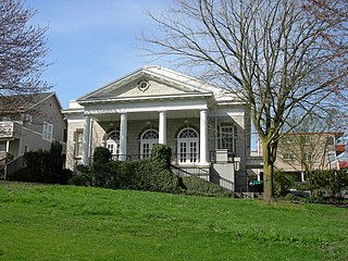
Columbia City is a neighborhood in southeastern Seattle, Washington, within the city's Rainier Valley district. It has a landmark-protected historic business district and is one of the few Seattle neighborhoods with a long history of ethnic and income diversity.

West Seattle is a conglomeration of neighborhoods in Seattle, Washington, United States. It comprises two of the thirteen districts, Delridge and Southwest, and encompasses all of Seattle west of the Duwamish River. It was incorporated as an independent town in 1902 before being annexed by Seattle five years later. Among the area's attractions are its saltwater beach parks along Elliott Bay and Puget Sound, including Alki Beach Park and Lincoln Park. The area is also known for its views of the Olympic Mountains to the west and the Cascade Range to the east. One-third of Seattle's green space and urban forest is located in West Seattle, much of it in the West Duwamish Greenbelt.

Madison Park is a neighborhood in eastern Seattle, Washington, United States. It is named after the city park at the foot of Madison Street on the Lake Washington shore. The neighborhood is generally bounded on the east by Lake Washington; on the south by East Prospect Street, beyond which is Denny-Blaine; on the west by Lake Washington Boulevard E.; and on the north by Union Bay. Madison Park generally consists of single-family housing with a small business district near the park.

Delridge is a district in Seattle, Washington, United States that stretches along Delridge Way, an arterial that follows the eastern slope of the valley of Longfellow Creek, from near its source just within the southern city limits north to the West Seattle Bridge over the Duwamish River. It is generally associated with the neighborhing district of West Seattle, or even considered a sub-district of West Seattle.

Mount Baker is a neighborhood in southeastern Seattle, Washington. The neighborhood's name comes from the view of Mount Baker in Whatcom County, that is seen by looking north over Lake Washington. It is bounded by Lake Washington to the east, Interstate 90 and then Leschi to the north, Rainier Valley to the west, and Columbia City to the south. The neighborhood has a community club and a rowing team. It hosts Seattle's annual Seafair, which includes an airshow featuring the U.S. Navy Blue Angels, hydroplane races, a fireworks show, and other festivities. Franklin High School and Garfield High School serve this area. It is part of Seattle's South End.

Crown Hill is a neighborhood in the city of Seattle, in the U.S. state of Washington.

Atlantic is a neighborhood in the Central District of Seattle, Washington, United States. It is the northernmost neighborhood in the Rainier Valley area, located between Mount Baker Ridge and Beacon Hill, and may also be considered part of South Seattle. It is home to the Judkins Park neighborhood.
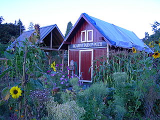
A P-Patch is a parcel of property used for gardening; the term is specific to Seattle, Washington. The "P" originally stood for "Picardo", after the family who owned Picardo Farm in Seattle's Wedgwood neighborhood, part of which became the original P-Patch.
Hawthorne Hills is a residential neighborhood in Seattle, Washington. It is officially split between the neighborhoods of Bryant and Windermere, but is generally recognized as a distinct neighborhood. The northern boundary is Northeast 65th Street. The southern and eastern boundary is Sand Point Way. The western boundary is 40th Avenue Northeast. Hawthorne Hills is bounded on the north by View Ridge, on the east by Windermere, on the south by Laurelhurst, and on the west by Bryant. There is a sign for the neighborhood along Sand Point Way.

Madison Valley is a neighborhood in Seattle located east of Capitol Hill; west of Washington Park; south of Montlake; and north of Madrona.

Squire Park is a neighborhood in the city of Seattle, in the U.S. state of Washington. According to the Squire Park Community Council, it is bounded on the south by S. Jackson Street, on the west by 12th Avenue and 12th Avenue S., on the north by E. Union Street, and on the east by 23rd Avenue and 23rd Avenue S., placing it within the Central District. Its main thoroughfares are E. Jefferson and Cherry Streets and E. Yesler Way and 14th Avenue. Swedish Medical Center's Cherry Hill campus is located here, Seattle University, a Jesuit University has part of its campus in Squire Park, as the Admissions, some dormitories and Athletics departments are east of 12th Avenue.
Southwest Hills is a neighborhood in the West Hills in the southwest section of Portland, Oregon, United States. The northeastern part of the neighborhood, above Goose Hollow and Downtown Portland, is known as Portland Heights. Much of the western portion of the neighborhood lies outside the Portland city limits, in unincorporated Multnomah County.
The Fairmount Park is a neighborhood of West Seattle in Seattle, Washington. It runs southwest along both sides of Fauntleroy Way, from SW Graham Street in the south to SW Edmunds Street in the north. Neighborhood features include Fairmount Playfield, a city park, and Fairmount Park Elementary School, part of the Seattle Public Schools system.

Olympic Hills is a neighborhood in the Lake City district of Seattle, Washington.

Arbor Heights is a neighborhood of West Seattle in Seattle Washington, made up of the area south of SW Roxbury Street, north and east of Puget Sound, but excluding the downhill portion on the west side of this region. It is the southernmost section of West Seattle.

Seaview is a neighborhood in West Seattle, Washington. Seaview is bordered by Puget Sound to the west, the Alki and Genesee neighborhoods to the north, Fairmount Park to the east, and Gatewood to the south.

Frank B. Cooper Elementary School, usually called Cooper School, serves students from kindergarten through 5th grade. Located in the Pigeon Point neighborhood of Delridge, Seattle, Washington, it is part of the Seattle Public Schools district. The school's 14-acre (57,000 m2) site is immediately adjacent to the 182-acre (0.74 km2) West Duwamish Greenbelt, one of Seattle's largest wildlife habitat corridors. This rich natural environment enhances the school's environmental education program.
Pinehurst is a neighborhood in the Northgate area of Seattle, Washington, United States. It is bounded by NE 145th Street to the north, NE Northgate Way to the south, I-5 to the west, and Lake City Way to the east. These boundaries were determined by the Pinehurst Community Council. Pinehurst's northern boundary of NE 145th Street makes Pinehurst one of the northernmost neighborhoods in the city of Seattle.

Hillman City is a primarily residential neighborhood in southeastern Seattle, Washington, located in the Rainier Valley and centered about a half mile south of the Columbia City neighborhood. It was annexed by Seattle in January 1907, along with the rest of the town of Southeast Seattle.

Briarcliff is a neighborhood in Seattle, Washington. The city's Department of Neighborhoods places Briarcliff on the west side of Magnolia, south of Discovery Park.