
Shoreline is a city in King County, Washington, United States. It is located between the city limits of Seattle and the Snohomish County border, approximately 9 miles (14 km) north of Downtown Seattle. As of the 2020 census, the population of Shoreline was 58,608, making it the 22nd largest city in the state. Based on per capita income, one of the more reliable measures of affluence, Shoreline ranks 91st of 522 areas in the state of Washington to be ranked.

Haller Lake is a small lake and neighborhood in north central Seattle, Washington, named for Theodore N. Haller, who platted the neighborhood in 1905. His father, Granville O. Haller, was one of Seattle's early settlers, an army officer who amassed a large estate in the region.
Pipers Creek is a 1.4-mile (2.3 km) urban stream that is located in the Broadview and Blue Ridge neighborhoods of Seattle, Washington, in the United States.

Bitter Lake is a neighborhood in Seattle, Washington, United States, named after its most notable feature, Bitter Lake. It was a mostly natural forest of Douglas-fir and Western Redcedar, inhabited by Native Americans, until the late 19th century. Development especially picked up when the Seattle-to-Everett Interurban streetcar reached the lake in 1906. A sawmill operated in the area until 1913, when most of the trees had been cut down.
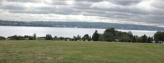
Magnuson Park is a park in the Sand Point neighborhood of Seattle, Washington, United States. At 350 acres (140 ha) it is the second-largest park in Seattle, after Discovery Park in Magnolia. Magnuson Park is located at the site of the former Naval Station Puget Sound, on the Sand Point peninsula with Pontiac and Wolf bays that juts into Lake Washington in northeast Seattle.

Carkeek Park is a 216 acres (87 ha) park located in the Broadview neighborhood of Seattle, Washington. The park contains Piper Orchard, Pipers Creek, play and picnic areas, picnic shelters, and hiking trails. A pedestrian bridge across the main lines of the BNSF Railway connects to the Carkeek Park sand beach on Puget Sound. Park program activities are largely out of the Carkeek Park Environmental Learning Center.

Discovery Park is a 534-acre (2.16 km2) park on the shores of Puget Sound in the Magnolia neighborhood of Seattle, Washington. As the city's largest public park, it contains 11.81 miles (19.01 km) of walking trails. The Discovery Park Loop Trail, designated a National Recreation Trail in 1975, runs 2.8 miles (4.5 km) through the park, connecting to other trails. Forests, beaches, prairies, and bluffs dominate the landscape of the park. Daybreak Star Cultural Center is within the park's boundaries. The West Point Lighthouse is located on West Point, the westernmost point of the park and the entire city of Seattle. On the south side of the North Beach strip is the West Point Treatment Plant which is almost entirely concealed from the marsh, beach, and trail.

Ravenna is a neighborhood in northeastern Seattle, Washington named after Ravenna, Italy. Though Ravenna is considered a residential neighborhood, it also is home to several businesses, many of which are located in the University Village, a shopping mall.

Delridge is a district in Seattle, Washington, United States that stretches along Delridge Way, an arterial that follows the eastern slope of the valley of Longfellow Creek, from near its source just within the southern city limits north to the West Seattle Bridge over the Duwamish River. It is generally associated with the neighborhing district of West Seattle, or even considered a sub-district of West Seattle.

Licton Springs or North College Park is a neighborhood in the informal Northgate district of North Seattle. It is bounded by Interstate 5 to the east, beyond which is Maple Leaf neighborhood and the Northgate Mall; Aurora Avenue N to the west, beyond which is Greenwood; N 85th Street to the south, beyond which is Green Lake, and N Northgate Way to the north, beyond which is Haller Lake.

Crown Hill is a neighborhood in the city of Seattle, in the U.S. state of Washington.

Matthews Beach is a neighborhood in Seattle, Washington; it and Meadowbrook are the southern neighborhoods of the annexed township of Lake City (1954). Matthews Beach lies about 2 miles (3.2 km) northeast of the University of Washington, about 8 miles (13 km) northeast of Downtown.
North Beach / Blue Ridge is a neighborhood in the city of Seattle, in the U.S. state of Washington.

Rainier Beach is a set of neighborhoods in Seattle, Washington that are mostly residential. Also called Atlantic City, Rainier Beach can include Dunlap, Pritchard Island, and Rainier View neighborhoods.

Daylighting is the opening up and restoration of a previously buried watercourse, one which had at some point been diverted below ground. Typically, the rationale behind returning the riparian environment of a stream, wash, or river to a more natural above-ground state is to reduce runoff, create habitat for species in need of it, or improve an area's aesthetics. In the United Kingdom, the practice is also known as deculverting.

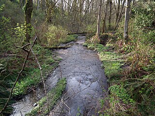
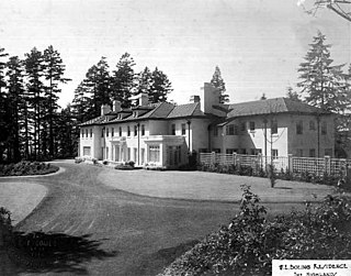
Boeing Creek is a stream in the U.S. state of Washington, located in the city of Shoreline, just north of Seattle. It is about 1.6 miles (2.6 km) long and empties into Puget Sound. The creek is heavily modified along its course, and in many places has been diverted into culverts. The watershed of Boeing Creek is about 11.2 square miles (29 km2) in size, with two main tributaries aside from the mainstem. The creek takes its name from William Boeing, who built a mansion along the creek in 1913. Despite the river modifications and stormwater pollution, the creek supports a variety of riparian habitats, native animals and fishes.
Cougar Mountain is a peak in the Issaquah Alps in King County, Washington. It is part of the highlands in the Eastside suburbs of Seattle, and at 1,614 feet (492 m) it is the lowest and westernmost of the Alps. About two-thirds of Cougar Mountain has experienced residential development, and is home to many neighborhood communities such as Lakemont. The forested heart of the hill was officially preserved by King County in June 1983 as Cougar Mountain Regional Wildland Park. Cougar Mountain is home to the Cougar Mountain Zoo.
The Highlands is a gated community founded in 1907 adjacent to Seattle, Washington's Broadview neighborhood, 12 mi (19 km) north of Downtown Seattle. In 1995 The Highlands became part of the city of Shoreline.

Naval Station Puget Sound is a former United States Naval station located on Sand Point in Seattle, Washington. Today, the land is occupied by Magnuson Park.

