Denny Triangle, Seattle

Last updated
Denny Triangle
Denny Triangle and South Lake Union skyline, from Westlake & Galer (2018).jpg
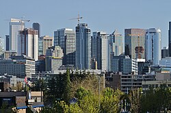
Denny Triangle and South Lake Union skyline in 2018
Seattle Map - Denny Regrade.png
Denny Triangle Highlighted in Pink
Coordinates: 47°37′00″N122°20′24″W / 47.61667°N 122.34000°W / 47.61667; -122.34000
CountryUnited States
State Washington
County King
City Seattle
ZIP Code
98101, 98121
Area Code 206
Differing definitions of the neighborhood borders: the yellow background follows the Seattle City Clerk's Neighborhood Map Atlas. The blue border shows "Belltown (Denny Regrade)" as defined by northwestplaces.com. The red border shows "Belltown" and the purple border shows "Denny Triangle", as defined by downtownseattle.com. Denny Regrade borders.jpg
Differing definitions of the neighborhood borders: the yellow background follows the Seattle City Clerk's Neighborhood Map Atlas. The blue border shows "Belltown (Denny Regrade)" as defined by northwestplaces.com. The red border shows "Belltown" and the purple border shows "Denny Triangle", as defined by downtownseattle.com.

The Denny Triangle is a neighborhood in Seattle, Washington, United States, that stretches north of Downtown Seattle to the grounds of Seattle Center. Its generally flat terrain was originally a steep hill, taken down as part of a mammoth construction project in the first decades of the 20th century known as the Denny Regrade, [1] which is another name for the neighborhood on the regraded area. The name Denny Triangle, referring to the northeastern portion of this regrading project, is a term that has gained currency as this neighborhood has seen increasing development in the first decades of the 21st Century.

Contents

View of Seattle from Denny Hill in 1882 photograph by Theodore Peiser Looking southwest from Denny Hill over Seattle, 1882 (PEISER 69).jpeg
View of Seattle from Denny Hill in 1882 photograph by Theodore Peiser

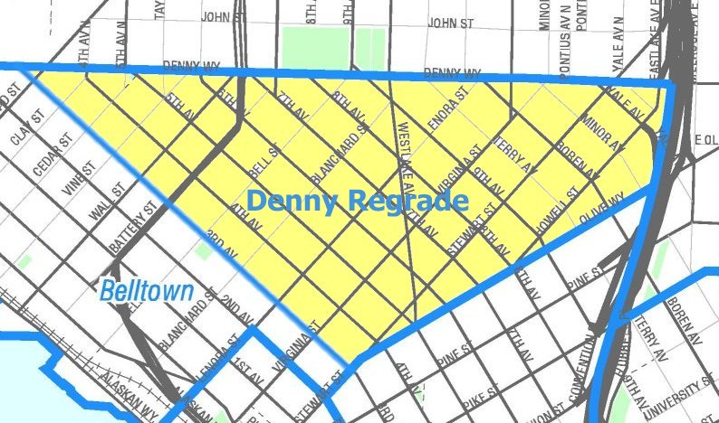
As with most Seattle neighborhoods, the Denny Triangle has no formal borders. The Seattle City Clerk's Neighborhood Map Atlas (which is published by the city but does not have official status as defining neighborhoods) defines the Denny Regrade as bounded on the north by Denny Way, on the southwest by Third Avenue, on the southeast by Olive Way, with a small eastern border on Interstate 5. [2] A 2009 map from northwestplaces.com treats the term "Denny Regrade" as synonymous with Belltown and shows both names as referring to a triangle bounded on the north by Denny Way, on the southwest by Western Avenue (two blocks inland of the Central Waterfront), and on the southeast by Stewart Street; the southern tip of this triangle falls in the northern part of Pike Place Market. [3] A map on downtownseattle.com agrees on the northern boundary at Denny Way, but splits this area into "Belltown" and the Denny Triangle and gives both a less regular shape. They divide Belltown to the southwest from the Denny Triangle to the northeast, with the border running mainly along Fifth Avenue but including a small number of properties along Denny Way west of Fifth Avenue as being in the Denny Triangle. They mark the southwest border of Belltown as a block closer to the water (Elliott Avenue) and draw a more ragged southeast border: west of Fifth Avenue, Belltown extends south only to Lenora Street, while east of Fifth Avenue the Denny Triangle is bounded in its westernmost block by Virginia Street and (once it crosses Westlake Avenue) by Olive Way, and with an eastern border on the same small piece of Interstate 5 as the City Clerk's map. [4]

Denny Hill

The 1884 Denny School (depicted here in 1900) on Battery Street between Fifth & Sixth Avenues was demolished in 1928, one of many major buildings demolished as part of the regrade project. Seattle - Denny School - 1900.jpg
The 1884 Denny School (depicted here in 1900) on Battery Street between Fifth & Sixth Avenues was demolished in 1928, one of many major buildings demolished as part of the regrade project.

Seattle is located on an isthmus between Lake Washington on the east and Puget Sound on the west. The north-south orientation of the lake and of the city's many hills is the result of glaciation. The terrain was first gouged by south-moving glaciers, and when they retreated, was marked by mounds of rock debris left in their wake. Denny and Queen Anne Hills are two of those north of what is now downtown Seattle. Denny Hill was removed in a series of regrades beginning in 1898 and ending in 1930. [5]

Regrading projects

Idealized bird's-eye view of the area in 1917, between Denny Regrade No. 1 and Denny Regrade No. 2. The major street running roughly horizontally in foreground is Westlake Avenue. The major street headed into the distance at right is Denny Way. Fifth Avenue marked the line between Denny Regrade No. 1 and Denny Regrade No. 2. Seattle's coming retail and apartment-house district - 1917.jpg
Idealized bird's-eye view of the area in 1917, between Denny Regrade No. 1 and Denny Regrade No. 2. The major street running roughly horizontally in foreground is Westlake Avenue. The major street headed into the distance at right is Denny Way. Fifth Avenue marked the line between Denny Regrade No. 1 and Denny Regrade No. 2.

The Denny Regrade project was the removal of Denny Hill, one of the proverbial seven hills of Seattle. It ran east from First Avenue between Pike Street and Denny Way. Hill and street were named after the Denny family, who were among the city's earliest white inhabitants. The First Avenue regrade was started in 1897 and completed on January 6, 1899. From 1902 to 1911, the hill was sluiced into Elliott Bay by pumping water from Lake Union using hydraulic mining techniques, in a series of regrades along Pike and Pine Streets, Second Avenue, and the massive Denny Regrade No. 1 which regraded everything remaining between Fifth Avenue and the waterfront. In 1929–30, Denny Regrade No. 2 removed the final pieces of the hill east of Fifth Avenue using steam shovels.

Photographs

See also

Related Research Articles

<span class="mw-page-title-main">Pioneer Square, Seattle</span> United States historic place

Pioneer Square is a neighborhood in the southwest corner of Downtown Seattle, Washington, US. It was once the heart of the city: Seattle's founders settled there in 1852, following a brief six-month settlement at Alki Point on the far side of Elliott Bay. The early structures in the neighborhood were mostly wooden, and nearly all burned in the Great Seattle Fire of 1889. By the end of 1890, dozens of brick and stone buildings had been erected in their stead; to this day, the architectural character of the neighborhood derives from these late 19th century buildings, mostly examples of Richardsonian Romanesque.

<span class="mw-page-title-main">Belltown, Seattle</span> Most densely populated neighborhood in Seattle, Washington

Belltown is the most densely populated neighborhood in Seattle, Washington, United States, located on the city's downtown waterfront on land that was artificially flattened as part of a regrading project. Formerly a low-rent, semi-industrial arts district, in recent decades it has transformed into a neighborhood of trendy restaurants, boutiques, nightclubs, and residential towers as well as warehouses and art galleries. The area is named after William Nathaniel Bell, on whose land claim the neighborhood was built.

<span class="mw-page-title-main">Capitol Hill, Seattle</span> Seattle neighborhood in Washington, United States

Capitol Hill is a densely populated residential district in Seattle, Washington, United States. One of the city's most popular nightlife and entertainment districts, it is home to a historic gay village and vibrant counterculture community.

<span class="mw-page-title-main">Street layout of Seattle</span>

The street layout of Seattle is based on a series of disjointed rectangular street grids. Most of Seattle and King County use a single street grid, oriented on true north. Near the center of the city, various land claims were platted in the 19th century with differently oriented grids, which still survive today. Distinctly oriented grids also exist in some cities annexed by Seattle in the early 20th century, such as Ballard and Georgetown. A small number of streets and roads are exceptions to the grid pattern.

<span class="mw-page-title-main">Downtown Seattle</span> Central business district of Seattle, Washington, U.S.

Downtown is the central business district of Seattle, Washington. It is fairly compact compared with other city centers on the U.S. West Coast due to its geographical situation, being hemmed in on the north and east by hills, on the west by Elliott Bay, and on the south by reclaimed land that was once tidal flats. It is bounded on the north by Denny Way, beyond which are Lower Queen Anne, Seattle Center, and South Lake Union; on the east by Interstate 5, beyond which is Capitol Hill to the northeast and Central District to the east; on the south by S Dearborn Street, beyond which is Sodo; and on the west by Elliott Bay, a part of Puget Sound.

<span class="mw-page-title-main">Queen Anne, Seattle</span> Seattle Neighborhood

Queen Anne is a neighborhood and geographic feature in Seattle, Washington, United States, located northwest of downtown. Queen Anne covers an area of 7.3 square kilometers (2.8 sq mi), and has a population of about 28,000. It is bordered by Belltown to the south, Lake Union to the east, the Lake Washington Ship Canal to the north and Interbay to the west.

<span class="mw-page-title-main">First Hill, Seattle</span> Wealthy neighborhood of Seattle

First Hill is a neighborhood in Seattle, Washington, United States. It is named for the hill on which it is located, which in turn is so named for being the first hill encountered while traveling east from downtown Seattle toward Lake Washington. First Hill is bounded on the west by Interstate 5, beyond which is Downtown, on the north by E. Pike and E. Madison Streets, beyond which is Capitol Hill, and on the south by Yesler Way, beyond which is the International District. The City of Seattle provides conflicting information about its eastern limit, beyond which are Cherry Hill and the Central District. Some describe it as being bounded by Broadway and Boren Avenues, while others describe it as being bounded by 12th Avenue.

<span class="mw-page-title-main">Denny Park (Seattle)</span>

Denny Park is a park located in the South Lake Union neighborhood of Seattle, Washington. It occupies the block bounded by John Street and Denny Way on the north and south and Dexter and 9th Avenues N. on the west and east.

<span class="mw-page-title-main">Cascade, Seattle</span> Neighborhood in Seattle, Washington, United States

Cascade is an urban neighborhood abutting Downtown Seattle, Washington, United States, located adjacent to South Lake Union. It is bounded by: Fairview Avenue North on the west, beyond which is the rest of the Cascade Neighborhood; the Interstate 5 interchange for Mercer St to the north, beyond which is Eastlake; Interstate 5 on the east, beyond which is Capitol Hill; and Denny Way on the south, beyond which is Denny Triangle. It is surrounded by thoroughfares Mercer Street (eastbound), Fairview Avenue N. and Eastlake Avenue E., and Denny Way. The neighborhood, one of Seattle's oldest, originally extended much further: west to Terry Avenue, south to Denny Hill on the South, and east to Melrose Avenue E through the area now obliterated by Interstate 5. Some recent writers consider Cascade to omit the northern "arm", while others extend it westward to cover most of South Lake Union.

<span class="mw-page-title-main">South Lake Union, Seattle</span> Neighborhood of Seattle

South Lake Union is a neighborhood in Seattle, Washington, so named because it is at the southern tip of Lake Union.

<span class="mw-page-title-main">Madison Park, Seattle</span>

Madison Park is a neighborhood in east central Seattle, Washington, USA, named after the city park at the foot of E. Madison Street on the Lake Washington shore. It is bounded on the east by Lake Washington; on the south by the intersection of Lake Washington Boulevard E. and 39th Avenue E., beyond which is Denny-Blaine; on the west by Lake Washington Boulevard E.; and on the north by Union Bay. Washington Park and the private Broadmoor community and golf course are subunits within Madison Park. The neighborhood's main thoroughfares are E. Madison Street and McGilvra Boulevard E..

<span class="mw-page-title-main">Eugene McAllaster</span>

Eugene Loring McAllaster was born April 20, 1866, in Pennsylvania. A distinguished Seattle, Washington, naval architect and engineer, he is most famous for designing the historic Seattle fireboat Duwamish. He was also a consulting engineer on Seattle's Denny Hill and Jackson Street regrades.

<span class="mw-page-title-main">Reginald H. Thomson</span>

Reginald Heber Thomson was a self-taught American civil engineer. He worked in Washington state, mainly in Seattle, where he became city engineer in 1892 and held the position for two decades. Alan J. Stein wrote that Thomson "probably did more than any other individual to change the face of Seattle" and was responsible for "virtually all of Seattle's infrastructure".

<span class="mw-page-title-main">Regrading in Seattle</span>

The topography of central Seattle was radically altered by a series of regrades in the city's first century of urban settlement, in what might have been the largest such alteration of urban terrain at the time.

<span class="mw-page-title-main">Broadway (Seattle)</span>

Broadway is a major north–south thoroughfare in Seattle, Washington. The 1.6-mile-long (2.6 km) arterial runs north from Yesler Way at Yesler Terrace through the First Hill and Capitol Hill neighborhoods to East Roy Street. Broadway East continues north to East Highland Drive. North of there the street is made up of shorter segments: one from just south of East Blaine Street to just north of East Miller Street, another from East Roanoke Street to East Shelby Street, and the last from East Allison Street to Fuhrman Avenue East.

<span class="mw-page-title-main">Pike Street</span> Street in Seattle

Pike Street is an east-west street in Seattle. It extends from Pike Place above Seattle's saltwater waterfront at Elliott Bay through Downtown Seattle, across Capitol Hill to the freshwater shore of Lake Washington at Lake Washington Boulevard. A segment less than a block long exists at Alaskan Way on Elliott Bay, connected to the rest of the street only by the pedestrian Pike Street Hill Climb; the bottom of the hillclimb under the Alaskan Way Viaduct was the original shoreline of the city before major modification and construction of the Seattle Seawall. It is included in the south-to-north mnemonic "Jesus Christ Made Seattle Under Protest" for the street layout of Seattle.

Denny Way is an east–west arterial street in downtown Seattle, Washington, United States. It forms the northern end of the Belltown street grid as well as the boundaries of Belltown, Lower Queen Anne, South Lake Union, Denny Triangle, and Cascade. The street continues east through Capitol Hill to Madrona as a minor neighborhood street, ending near Madrona Park on Lake Washington.

<span class="mw-page-title-main">1st Avenue (Seattle)</span> Major street in Seattle, Washington, US

1st Avenue is a major street in Seattle, Washington, United States. It traverses Downtown Seattle, including Pioneer Square and Belltown, as well as the adjacent neighborhoods of SoDo and Lower Queen Anne. Numerous landmarks including parks, museums, and historic buildings are located along the street, including Pike Place Market. The Great Seattle Fire of 1889 destroyed much of it and it had to be rebuilt. Parades have taken place on it before and after the fire.

<span class="mw-page-title-main">Westlake Avenue</span>

Westlake Avenue is a major street in Seattle, Washington, connecting Downtown Seattle to the neighborhoods of South Lake Union, Westlake and northeastern Queen Anne. The street runs north–south along the west side of Lake Union for 2.5 miles (4.0 km) from McGraw Square to the Fremont Bridge.

References

  1. "Seattle Neighborhoods: Belltown-Denny Regrade -- Thumbnail History - HistoryLink.org".
  2. Denny Regrade, map NN-1243L from Seattle City Clerk's Neighborhood Map Atlas.
  3. Downtown Map, northwestplaces.com, dated 2009, accessed online 2014-01-12.
  4. MID Marketing Neighborhoods Map, Cropped Archived 2014-01-13 at the Wayback Machine , downtownseattle.com, accessed online 2014-01-12.
  5. Greg Lange (1999-01-16), "Seattle's Denny Regrade is completed after 32 years on December 10, 1930.", HistoryLink , Seattle: History Ink, retrieved 2018-12-16, Denny Hill was lowered in three phases -- 1898-1899, 1903-1911, and 1928-1930 -- over the course of 32 years.