Cascade, Seattle

Last updated
Cascade, Seattle
Seattle - Cascade Playground 01.jpg
The Cascade Playground (former playground of the long-demolished Cascade School)
Seattle Map - Cascade.png
Cascade Highlighted in Pink
Coordinates: 47°37′28″N122°20′04″W / 47.62444°N 122.33444°W / 47.62444; -122.33444
CountryUnited States
State Washington
County King
City Seattle
Zip Code
98109
Area Code 206

Cascade is an urban neighborhood abutting Downtown Seattle, Washington, United States, located adjacent to South Lake Union. It is bounded by: Fairview Avenue North on the west, beyond which is the rest of the Cascade Neighborhood; the Interstate 5 interchange for Mercer St to the north, beyond which is Eastlake; Interstate 5 on the east, beyond which is Capitol Hill; and Denny Way on the south, beyond which is Denny Triangle. It is surrounded by thoroughfares Mercer Street (eastbound), Fairview Avenue N. and Eastlake Avenue E. (north- and southbound), and Denny Way (east- and westbound). The neighborhood, one of Seattle's oldest, originally extended much further: west to Terry Avenue, south to Denny Hill (regraded away 1929–1931) on the South, and east to Melrose Avenue E through the area now obliterated by Interstate 5. [1] Some recent writers consider Cascade to omit the northern "arm" (east of Lake Union), while others extend it westward to cover most of South Lake Union. [2]

Contents

Historic structures in Cascade Neighborhood include St Spiridon's Orthodox Cathedral, Immanuel Lutheran Church, and several defunct laundry blocks. In 2007, a development named Alley24 was built around the New Richmond Laundry Building, a City of Seattle Landmark located between John and Thomas Streets and Yale and Pontius Avenues North. The historic façade was maintained in the new design by architecture firm NBBJ, who also relocated their headquarters to Alley24. The property is jointly owned by PEMCO and Paul Allen's development company Vulcan Inc. [3] Vulcan owns roughly approximately 6 acres in Cascade Neighborhood, a lower percentage of the land than in the rest of South Lake Union. [4]

History

This unprepossessing house at 1206 Republican St. dates from 1890. Demolished in late 2008, it was the oldest surviving building in the Cascade Neighborhood. Seattle - 1206 Republican Street 02.jpg
This unprepossessing house at 1206 Republican St. dates from 1890. Demolished in late 2008, it was the oldest surviving building in the Cascade Neighborhood.
Hemrich Brothers' Brewing Company (built 1897, pictured 1900), Howard Ave. N. (now Yale Ave. N.), between Republican and Mercer Streets Seattle - Hemrich Bro's Brewing Co - 1900.jpg
Hemrich Brothers' Brewing Company (built 1897, pictured 1900), Howard Ave. N. (now Yale Ave. N.), between Republican and Mercer Streets
St. Spiridon Russian Orthodox Cathedral. The cathedral is listed as a Seattle Landmark. Seattle - St Spiridon 04.jpg
St. Spiridon Russian Orthodox Cathedral. The cathedral is listed as a Seattle Landmark.
Cascade People's Center and Immanuel Lutheran Church. The church is listed on the National Register of Historic Places. Seattle - Cascade People's Center 01.jpg
Cascade People's Center and Immanuel Lutheran Church. The church is listed on the National Register of Historic Places.
South Lake Union Streetcar barn, 2007 SLU Streetcar at maintenance facility.jpg
South Lake Union Streetcar barn, 2007
Seattle School District Supply Center, the building that replaced the Cascade School Seattle School District Supply Center 01.jpg
Seattle School District Supply Center, the building that replaced the Cascade School

Cascade grew up in the late 19th and early 20th century as a blue-collar neighborhood with a mixture of housing and one of the city's first industrial areas. It was the original home of St. Demetrios Greek Orthodox Church (built 1919–1921; congregation moved 1963; demolished 1995), and remains the home of St. Spiridon Russian Orthodox Cathedral (established 1895, present church completed 1938) and Immanuel Lutheran Church (established 1890, present church completed 1912). [1] [7] [8] [9] [10]

Pioneers

Like most of Seattle, the Cascade Neighborhood was originally heavily forested. In the 1860s, David Denny and Thomas Mercer first claimed portions of this land. However, initial development was a bit west of Cascade, at southwest Lake Union, which became a transportation nexus and where Denny established the lake's first sawmill. By the 1880s, more mills and more cleared land led to the origin of Cascade as a residential and industrial neighborhood, tied into water transportation. [7]

Another notable pioneer was Margaret Pontius, known for her extensive work as what would now be called a foster parent. She and her husband, Rezius Pontius, lived in the neighborhood by 1885, and by 1889 had built a Queen Anne style mansion, designed by John Parkinson, along Denny Way near what is now Yale Avenue. [11]

Cascade was settled largely by Russians (some via Alaska [12] ), Swedes, Norwegians, and Greeks. In 1894, the Cascade School (also designed by Parkinson [12] ) opened and the neighborhood acquired a name. As the neighborhood grew, the school expanded in 1904 and 1908. [7] Cascade businesses in this era included sawmills, shingle mills, and boat yards along the lake, as well as cabinetry and furniture shops, grocery stores, laundries, and boarding houses. [13]

Both landscape architect John C. Olmsted (in 1903) and city planner Virgil Bogue (in 1910–1911) believed that the neighborhood was best suited for industrial use, although Olmsted unsuccessfully proposed that there also be a small park on the lake. [7] Denny Regrade No. 1 (completed 1911) took out nearly half of Denny Hill, making Cascade more accessible from downtown Seattle. [14] The Ford plant, designed by John Graham Sr. and built in 1914, was the Ford Motor Company's first factory built west of the Mississippi River. [15] When the Lake Washington Ship Canal opened in 1917, maritime and industrial uses intensified. The area also became the center for the city's large laundries, as well as smaller machine shops. [7] Cascade-area laundries played a crucial role in Seattle labor history, with a successful fight for the 8-hour day in the years 1917 through 1918. [15]

Great Depression

When the Great Depression coincided with the decline of the extractive economy in Greater Seattle, Cascade began to decline both economically and in terms of population, with its most stable remaining industries being shipbuilding and other marine activities. [7] Howard Wright General Contractors were operating out of 409 Yale Avenue N, where they are still located as of 2008. There was also a business district between the 300 and 600 blocks of Eastlake, mainly on the west side of the street, including grocery stores, a pharmacy, a meat shop, automobile repair, furniture repair, a cabinetmaker, a beauty parlor, a barbershop, several drinking establishments, and a dye works. Although no buildings remain on the east side of the street, which abuts Interstate 5, many of these west-side buildings survive. However, with the freeway cutting it off from Capitol Hill, this is much less of a business district today. [16]

Postwar period

The decline of the depression years was briefly arrested by World War II, as the U.S. Navy built a reserve center on the site of David Denny's former mill, just west of Cascade and Kenworth expanded a factory on Mercer Street. Decline resumed after the war, and was greatly exacerbated when the April 13, 1949 earthquake caused structural damage to the Cascade School. [7] Controversy ensued over whether or not to repair the school, but it was ultimately demolished since local businesses led by the Seattle Times desired an increasingly industrial rather than residential character neighborhood. [17] The school was replaced by a warehouse for the school district, while its playground remained as a public park. [7]

The year 1949 also saw the first seeds of the "new" Cascade Neighborhood that would emerge almost half a century later: the Washington Teachers Credit Union was established, with quarters on Eastlake Avenue. It would become the Washington School Employees Credit Union (1963), and eventually part of PEMCO Financial Services, still based in the Cascade Neighborhood as of 2008. [7]

New zoning ordinances based on the 1956 Comprehensive Plan of Seattle forbade any new residential uses in Cascade Neighborhood. The plan also recommended two new freeways through the area. On the northern edge, the Bay Freeway would cover roughly nine city blocks between Mercer and Valley Streets, with ramps connecting to the Aurora Freeway which had been constructed in 1932. The city lacked funding for the project and plans were eventually scrapped along with the R.H. Thomson Expressway. The second freeway was Interstate 5, which was constructed in 1962. More than seven blocks of residences and retail businesses on the east side of Eastlake were razed to make way for Interstate 5. The freeway cut Cascade off entirely from neighboring Capitol Hill. [7] Previously they had been tied together by multiple streets and stairways. [18] [19] (The upper half-block of the E. Republican Street Stairway or Republican Hill Climb east of Melrose Ave E. remains east of the freeway, and has status as a city landmark; it once extended two blocks farther, down to Eastlake Ave E. [20] [21] ) Currently, the only remaining direct route between the two is Denny Way at the south border of the neighborhood. [22]

1960s

The Seattle Times Building had been built in 1930 just west of Fairview Avenue. The Seattle Times ; [23] in the 1960s, the Times purchased and razed acres of homes near its headquarters for parking lots and future development opportunities. [7] (One building they purchased was, for a time, operated as the Seattle Concert Theater, but even that was "hastily razed" in the early 1980s to "head off a landmarks designation". [24] ) Karin Link remarks: "The relationship between the Seattle Times and the Cascade Neighborhood is still considered problematic." [25]

In the 1960s, the University of Washington's College of Architecture and Urban Planning described the area as "blighted". [26] The 1969 Bay Freeway plan for a proposed elevated freeway to connect Interstate 5 with Seattle Center would have cut off the neighborhood from the Lake, but was voted down in 1972. Cascade struggled on as a blue-collar residential and light industrial neighborhood. [7]

1970s

In the early 1970s, activists including a University of Washington student named Frank Chopp began the Cascade Shelter Project, setting up geodesic domes on vacant lots to live in. A 1975 report by Folke Nyberg and Victor Steinbrueck included Cascade as a historic residential section of Seattle, [27] and in 1977 the Housing In Cascade study by Paul Schell, then Director of Seattle Department of Community Development, recommended a "Special Review District" in Cascade. [28] However, the city council took no action on the proposal.

1980s

As the local economy strengthened in the late 1980s, Cascade's cheap land and central location began to attract new uses. The northwest corner of the neighborhood became the campus of the Fred Hutchinson Cancer Research Center [7] and at the north tip of Cascade, the old City Light Steam Plant (a decommissioned electrical generation facility) became the headquarters of Zymogenetics. [29] Gentrification had begun. Although a proposal to transform a north–south corridor just west of Cascade into a 74-acre (30 ha) park was twice defeated by the voters (in 1995 and in 1996), gentrification continued apace, largely driven by tech billionaire and developer Paul Allen's Vulcan Northwest group. [7]

1990s

Two large changes in the south part of Cascade in the 1990s were the demolition of the old St. Demetrios Church (along with the Overall Laundry) to build the new REI flagship store, and the demolition of the 1907 wood-frame Lillian Apartments by Vulcan Northwest. The demolition was opposed by low-income housing advocates. [30]

Notable residents

Teamsters labor leader Dave Beck grew up in and around Cascade Neighborhood, attended the Cascade School, and delivered newspapers there. He followed his mother into laundry work, which brought him into labor organizing. [15]

Detail of tilework, 117-121 Yale Ave. N, the former Rodgers tile company and the Kuvshinoffs' home and studio. Seattle - 117 Yale Ave N detail 01.jpg
Detail of tilework, 117-121 Yale Ave. N, the former Rodgers tile company and the Kuvshinoffs' home and studio.

Among the notable residents of Cascade were cubist artist Nicolai Kuvshinoff and his wife Bertha Horne Kuvshinoff, who dubbed her ghostly style of painting "phantasism". Both are represented in the permanent collection of the Seattle Art Museum. Kuvshinoff arrived in Cascade from Russia in 1915. His father, the Rev. Vasily Kuvshinoff, brought with him icons and relics given to him by the Romanovs, which he bequeathed to St. Spiridon Orthodox Cathedral, where he officiated. Nicolai Kuvshinoff appears to have painted religious murals in the Cathedral. From 1955 to 1960 Kuvshinoff and his wife lived and worked in Paris, but they returned to Cascade, where they remained until Nicolai's death in 1997 (Bertha lived two years longer). During most of their time in Cascade, they lived in the former Rodgers Tile Company building at 117-121 Yale Ave. N, later the 911 Contemporary Arts Center and now the Feathered Friends outdoor equipment shop. [31]

Cascade Playground

Immanuel Lutheran seen from the Cascade P-Patch adjacent to the Cascade Playground, 2007. Seattle - Immanuel Lutheran from Cascade P-Patch.jpg
Immanuel Lutheran seen from the Cascade P-Patch adjacent to the Cascade Playground, 2007.
WPA-built restrooms, Cascade Playground; Supply Laundry in background. Seattle - Cascade playground restrooms 02A.jpg
WPA-built restrooms, Cascade Playground; Supply Laundry in background.

The Cascade Playground (now also known as Cascade Park), originally the playground of the now-demolished Cascade School, has two play areas, a wide field, a picnic table, and restrooms. The park is adjacent to an active community P-Patch (allotment garden). Improvements to the Cascade Playground play areas, field, and entrance were unveiled in spring 2005, financed by the Pro Parks Levy. Sharing a city block with the playground and P-Patch is the Cascade People's Center, a volunteer organization that partners with over 100 businesses, churches, organizations, and community groups to address advocacy for social and economic justice.

By 1931, although most of this block had come to be owned by the City of Seattle or the School Board, a number of houses remained owned by individuals. By the end of 1931, however, the owners of these houses had sold out and the buildings were removed (although some basements may still be intact under the park surface). There was debate in the neighborhood over building the playground; in 1934, the pro-playground group eventually prevailed. Still, as late as 1937, the Fairview-Stewart Improvement Club was protested that the Cascade School was old and out of date, itself not worth preserving, and that the increasingly industrial and commercial neighborhood did not need a playfield. [23] [32]

Between 1934 and 1939, WPA workers built a retaining wall (only part of which survive), the rest rooms at the northeast corner of the park, and a wading pool (which originally was part of a Japanese stone garden). [23] [32] [33] [34] [35]

By the 1970s, according to the Seattle Department of Neighborhoods, "the playground site was somewhat bleak and known by locals as the 'Sahara Desert'". A 1971 renovation included a mural on the retaining wall, funded by the Seattle Arts Commission and designed by Mike Love and George Shayler. [32] This was followed by another round of improvements in 2005.

Landmarks and historic sites

See also the listing of Landmarks and historic sites in the South Lake Union neighborhood , most of which fall within what are considered by some to be the borders of the Cascade neighborhood.

Building or
structure
AddressListingPhoto
Ford Assembly Plant Building
Now Public Storage
1155 Valley St. Seattle landmark Seattle - old Ford assembly plant 02.jpg
Immanuel Lutheran Church 1215 Thomas St. Seattle landmark
NRHP
Seattle - Immanuel Lutheran 02.jpg
Jensen Block601-611 Eastlake Ave. E Seattle landmark Seattle - Jensen Block 01.jpg
Lake Union Steam Plant and Hydro House
Now Zymogenetics
1179 Eastlake Ave. E Seattle landmark Lake Union Steam Plant 07.jpg
New Richmond Laundry
Now part of the Alley24 development
224 Pontius Ave. N Seattle landmark Seattle - Alley 24 - 01.jpg
St. Spiridon Russian Orthodox Cathedral 400 Yale Ave. N Seattle landmark
Seattle - St Spiridon 04.jpg
Supply Laundry Building
Now part of the Stackhouse development
1265 Republican St. Seattle landmark
NRHP
Seattle - Supply Laundry Company 01.jpg

In addition, the surviving portion of the East Republican Street Stairway that once connected Cascade to Capitol Hill is a designated Seattle landmark. However, the portion of it that remains is separated from Cascade by Interstate 5.

Building or
structure
AddressListingPhoto
East Republican Street Stairway Between Melrose Ave. E and Bellevue Ave. E;
Originally extended beyond Bellevue Ave. E to Eastlake Ave. E
Seattle landmark Seattle - E Republican St staircase 01.jpg

Related Research Articles

<span class="mw-page-title-main">Lake Union</span> Lake in Seattle, Washington, U.S.

Lake Union is a freshwater lake located entirely within the city limits of Seattle, Washington, United States. It is a major part of the Lake Washington Ship Canal, which carries fresh water from the much larger Lake Washington on the east to Puget Sound on the west. The easternmost point of the lake is the Ship Canal Bridge, which carries Interstate 5 over the eastern arm of the lake and separates Lake Union from Portage Bay. Lake Union is the namesake of the neighborhoods located on three of its shores: Eastlake, Westlake and South Lake Union. Notable destinations on the lake include Lake Union Park, the Museum of History & Industry (MOHAI), and the Center for Wooden Boats on the southern shore and Gas Works Park on the northern shore.

<span class="mw-page-title-main">Portage Bay</span>

Portage Bay is a body of water, often thought of as the eastern arm of Lake Union, that forms a part of the Lake Washington Ship Canal in Seattle, Washington.

<span class="mw-page-title-main">Street layout of Seattle</span>

The street layout of Seattle is based on a series of disjointed rectangular street grids. Most of Seattle and King County use a single street grid, oriented on true north. Near the center of the city, various land claims were platted in the 19th century with differently oriented grids, which still survive today. Distinctly oriented grids also exist in some cities annexed by Seattle in the early 20th century, such as Ballard and Georgetown. A small number of streets and roads are exceptions to the grid pattern.

<span class="mw-page-title-main">Denny Triangle, Seattle</span> Neighborhood in Seattle

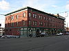
The Denny Triangle is a neighborhood in Seattle, Washington, United States, that stretches north of Downtown Seattle to the grounds of Seattle Center. Its generally flat terrain was originally a steep hill, taken down as part of a mammoth construction project in the first decades of the 20th century known as the Denny Regrade, which is another name for the neighborhood on the regraded area. The name Denny Triangle, referring to the northeastern portion of this regrading project, is a term that has gained currency as this neighborhood has seen increasing development in the first decades of the 21st Century.

<span class="mw-page-title-main">Eastlake, Seattle</span> Neighborhood of Seattle in Washington, United States

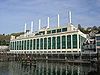
Eastlake is a neighborhood in Seattle, Washington, so named because of its location on the eastern shore of Lake Union. Its main thoroughfare is Eastlake Avenue E., which runs from Howell Street at the northeast corner of Downtown north over the University Bridge to the University District, where it connects to Roosevelt Way N.E. and 11th Avenue N.E. A second thoroughfare is Boylston Avenue E.; as an arterial, it parallels Interstate 5 for the four blocks between E. Newton Street to the south and E. Roanoke Street to the north, acting as an extension of Capitol Hill's Lakeview Boulevard E.

<span class="mw-page-title-main">Queen Anne, Seattle</span> Seattle Neighborhood

Queen Anne is a neighborhood and geographic feature in Seattle, Washington, United States, located northwest of downtown. Queen Anne covers an area of 7.3 square kilometers (2.8 sq mi), and has a population of about 28,000. It is bordered by Belltown to the south, Lake Union to the east, the Lake Washington Ship Canal to the north and Interbay to the west.

<span class="mw-page-title-main">Washington Park Arboretum</span> Arboretum at the University of Washington

Washington Park is a public park in Seattle, Washington, United States, most of which is taken up by the Washington Park Arboretum, a joint project of the University of Washington, the Seattle Parks and Recreation, and the nonprofit Arboretum Foundation. Washington Park also includes a playfield and the Seattle Japanese Garden in its southwest corner. To the north is Union Bay; to the west are Montlake and Madison Valley; to the south is the Washington Park neighborhood; and to the east is the Broadmoor Golf Club.

<span class="mw-page-title-main">Transportation in Seattle</span> Overview of transportation modes and routes in Seattle, Washington, U.S.

Transportation in Seattle is largely focused on the automobile like many other cities in western North America; however, the city is just old enough for its layout to reflect the age when railways and trolleys predominated. These older modes of transportation were made for a relatively well-defined downtown area and strong neighborhoods at the end of several former streetcar lines, now mostly bus lines.
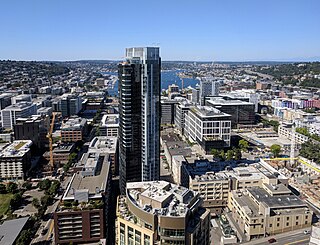
<span class="mw-page-title-main">South Lake Union, Seattle</span> Neighborhood of Seattle

South Lake Union is a neighborhood in Seattle, Washington, so named because it is at the southern tip of Lake Union.

<span class="mw-page-title-main">P-Patch</span>

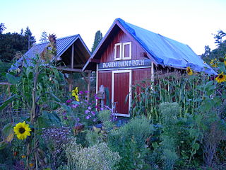
A P-Patch is a parcel of property used for gardening; the term is specific to Seattle, Washington. The "P" originally stood for "Picardo", after the family who owned Picardo Farm in Seattle's Wedgwood neighborhood, part of which became the original P-Patch.

<span class="mw-page-title-main">Interstate 90 in Washington</span> Interstate highway in Washington

Interstate 90 (I-90), designated as the American Veterans Memorial Highway, is a transcontinental Interstate Highway that runs from Seattle, Washington, to Boston, Massachusetts. It crosses Washington state from west to east, traveling 298 miles (480 km) from Seattle across the Cascade Mountains and into Eastern Washington, reaching the Idaho state line east of Spokane. I-90 intersects several of the state's other major highways, including I-5 in Seattle, I-82 and U.S. Route 97 (US 97) near Ellensburg, and US 395 and US 2 in Spokane.

<span class="mw-page-title-main">Interstate 5 in Washington</span> Interstate highway in Washington

Interstate 5 (I-5) is an Interstate Highway on the West Coast of the United States that serves as the region's primary north–south route. It spans 277 miles (446 km) across the state of Washington, from the Oregon state border at Vancouver, through the Puget Sound region, to the Canadian border at Blaine. Within the Seattle metropolitan area, the freeway connects the cities of Tacoma, Seattle, and Everett.

<span class="mw-page-title-main">David Denny</span> American judge

David Thomas Denny was a member of the Denny Party, who are generally collectively credited as the founders of Seattle, Washington, USA. Though he ultimately underwent bankruptcy, he was a significant contributor to the shape of the city. Roger Sale, in his book Seattle, Past to Present, described him as having been "the pioneer to turn to if one had a plan that would be 'good for Seattle', and one needed a respectable tone and a willing investor."

<span class="mw-page-title-main">Central Waterfront, Seattle</span> Neighborhood in Seattle

The Central Waterfront of Seattle, Washington, United States, is the most urbanized portion of the Elliott Bay shore. It runs from the Pioneer Square shore roughly northwest past Downtown Seattle and Belltown, ending at the Broad Street site of the Olympic Sculpture Park.

<span class="mw-page-title-main">Architecture of Seattle</span> Overview of the architecture in Seattle

The architecture of Seattle, Washington, the largest city in the Pacific Northwest region of the U.S., features elements that predate the arrival of the area's first settlers of European ancestry in the mid-19th century, and has reflected and influenced numerous architectural styles over time. As of the early 21st century, a major construction boom continues to redefine the city's downtown area as well as neighborhoods such as Capitol Hill, Ballard and, perhaps most dramatically, South Lake Union.

<span class="mw-page-title-main">Denny Substation</span> Electrical substation in Seattle, Washington

The Denny Substation is an electrical substation located in the South Lake Union neighborhood of Seattle, Washington, and operated by Seattle City Light. The facility takes up a whole city block along Denny Way and features a community center, interpretive exhibits, a dog park, and public art.

Denny Way is an east–west arterial street in downtown Seattle, Washington, United States. It forms the northern end of the Belltown street grid as well as the boundaries of Belltown, Lower Queen Anne, South Lake Union, Denny Triangle, and Cascade. The street continues east through Capitol Hill to Madrona as a minor neighborhood street, ending near Madrona Park on Lake Washington.

<span class="mw-page-title-main">Westlake Avenue</span>

Westlake Avenue is a major street in Seattle, Washington, connecting Downtown Seattle to the neighborhoods of South Lake Union, Westlake and northeastern Queen Anne. The street runs north–south along the west side of Lake Union for 2.5 miles (4.0 km) from McGraw Square to the Fremont Bridge.

References

  1. 1 2 History, Organizational Description, Boundaries, Cascade Neighborhood Council, November 1997. Accessed 6 June 2011.
  2. Link 2004 , p. 1
  3. Alley24, A New Face for Seattle: A LEED-certified speculative development in Seattle is both environmentally and economically sustainable Archived October 6, 2011, at the Wayback Machine , Sebastian Howard, GreenSource, March 2009. Accessed 6 June 2011.
  4. Who's built what in South Lake Union (also see map), Eric Pryne, Seattle Times. Accessed 6 June 2011.
  5. Summary for 1206 Republican ST / Parcel ID 2467400237, Seattle Department of Neighborhoods. Accessed online 4 February 2008.
  6. Seattle and the Orient (1900), The Times Printing Company (Seattle), p. 71.
  7. 1 2 3 4 5 6 7 8 9 10 11 12 13 14 Louis Fiset, Seattle Neighborhoods: Cascade and South Lake Union – Thumbnail History, HistoryLink, April 9, 2001. Accessed 3 February 2008.
  8. Dorothea Mootafes, Theodora Dracopoulos Argue, Paul Plumis, Perry Scarlatos, Peggy Falangus Tramountanas, eds., A History of Saint Demetrios Greek Orthodox Church and Her People, Saint Demetrios Greek Orthodox Church, 2007 (1996). p. 65, 73, 128–131.
  9. Summary for 1310 Harrison ST / Parcel ID 6847700030, Seattle Department of Neighborhoods. Accessed 3 February 2008. This is a description of the Sts. Cyril and Methodius Education Building adjacent to St. Spiridon, and mentions the construction date of the latter.
  10. Walt Crowley, National Trust Guide Seattle: America's Guide for Architecture and History (1998), John Wiley and Sons, ISBN   0-471-18044-0, p.167.
  11. Link 2004 , p. 4
  12. Link 2004 , p. 7
  13. Link 2004 , p. 8
  14. Link 2004 , pp. 13–14
  15. Link 2004 , p. 14
  16. Insurance Maps of Seattle, Washington, Volume 4, Sanborn Map Company, 1917–June 1950, sheets 441, 442, 451, 468, 470, 471, 484, 485, 486; especially 471, 486.
  17. Link 2004 , pp. 14–15
  18. Landmarks Alphabetical Listing for E Archived 2011-07-21 at the Wayback Machine , Seattle Department of Neighborhoods. Retrieved on 2008-02-06.
  19. Paul Dorpat, Seattle Neighborhoods: Republican Hill Climb between Capitol Hill and the Cascade Neighborhood completed on February 25, 1910, HistoryLink, 6 May 2001. Retrieved on 2008-02-06.
  20. Map NN-1230-L, Seattle City Clerk's Neighborhood Map Atlas, Seattle City Clerk's Office. Retrieved 6 February 2008.
  21. Eric Scigliano, Publisher's prerogative Archived 2011-05-16 at the Wayback Machine , Seattle Weekly, 20 June 2001. Accessed online 6 February 2008.
  22. Link 2004 , p. 16
  23. Link 2004 , p. 15
  24. Folke Nyberg and Victor Steinbrueck, An Urban Resource Inventory for Seattle (Seattle: Historic Seattle Preservation and Development Authority, 1975). Retrieved on 2011-06-04 from http://www.historicseattle.org/resources/neighborhoodinventories.aspx Archived 2011-09-28 at the Wayback Machine .
  25. Housing in Cascade : Cascade Neighborhood Study prepared for the Seattle Department of Community Development / Richardson Associates, Northwest American, Northwest Environmental Technology Laboratories. Available from UW Libraries, HT177.S6 H69.
  26. "ZymoGenetics' Steam Plant Facility: A Brief History. Zymogenetics". Archived from the original on 2008-05-09. Retrieved 2008-02-09..
  27. Link 2004 , pp. 16–17
  28. Summary for 117 Yale AVE / Parcel ID 6849700075, Seattle Department of Neighborhoods. Accessed 5 February 2008.
  29. 1 2 3 Summary for Harrison-Thomas St, Minor-Pontius AVE / Parcel ID 2467400335 (Cascade Playground). Seattle Department of Neighborhoods. Retrieved on 2008-02-06 from http://web1.seattle.gov/dpd/historicalsite/QueryResult.aspx?ID=131518019.
  30. Summary for Harrison-Thomas St, Minor-Pontius AVE / Parcel ID 2467400335 (Cascade Playground Wading Pool and Garden), Seattle Department of Neighborhoods. Accessed online 6 February 2008.
  31. Summary for Harrison-Thomas St, Minor-Pontius AVE / Parcel ID 2467400335 (Cascade Playground Retaining Walls), Seattle Department of Neighborhoods. Accessed online 6 February 2008.
  32. Summary for Harrison-Thomas St, Minor-Pontius AVE / Parcel ID 2467400335 (Cascade Playground Comfort Station), Seattle Department of Neighborhoods. Accessed online 6 February 2008.

Additional references