Northgate, Seattle

Last updated
Northgate, Seattle
Northgate Skyline, Seattle.jpg
The skyline of central Northgate from North Seattle College
Seattle Map - Northgate.png
Northgate highlighted in Pink
Coordinates: 47°42′30″N122°19′42″W / 47.70833°N 122.32833°W / 47.70833; -122.32833
CountryUnited States
State Washington
County King
City Seattle
Zip Code
98125
Area Code 206

Northgate is a neighborhood in north Seattle, Washington, named for and surrounding Northgate Mall, the first covered mall in the United States. [1] Its north-south principal arterials are Roosevelt Way NE and Aurora Avenue N (SR 99), and its east-west principal arterials are NE Northgate Way and 130th Street. Minor arterials are College Way-Meridian Avenue N, 1st, 5th, and 15th avenues NE. [2] Interstate 5 runs through the district. Besides the eponymous mall, the most characteristic distinctions of the area are North Seattle College (NSC) and the south fork of the Thornton Creek watershed and Seattle Kraken Iceplex center.

Contents

History

Prehistory

What is now Northgate has been inhabited since the end of the last glacial period (c. 8,000 BCE10,000 years ago). The Dkhw’Duw’Absh, People of the Inside and Xacuabš, People of the Large Lake, Lushootseed (Skagit-Nisqually) Coast Salish native people had used the Liq'tid Springs area as a spiritual health spa. They harvested cranberries from the Slo’q `qed (SLOQ-qed, bald head), an 85 acre (34 ha) marsh and bog at what is now the NSCC car park, Interstate 5 interchange, and Northgate Mall. Large open areas for game habitat and foraging (anthropogenic grasslands) were maintained in what are now these neighborhoods by selective burning every few years. Today the Native American descendants are represented by the Duwamish tribe.

Development

The residential part of the Thornton Place complex, immediately south of Northgate Mall. Seattle - Thornton Place - pano 01.jpg
The residential part of the Thornton Place complex, immediately south of Northgate Mall.

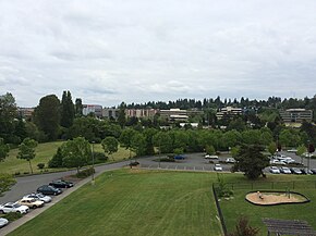
The Northgate area has been subject to a large amount of residential and commercial development in the last few years, and many huge projects are underway. The height limits in the area have been increased to 85' to allow for further population growth.

In 2009 the Northgate Mall was remodeled and added dozens more retail shops. In 2006, a new park, library, and community center opened in the Northgate neighborhood across 5th Ave NE from Northgate Mall. These are part of the city's plan to accelerate development in Northgate.[ citation needed ]

While there is much commerce in the area, hotel development has been limited with only the Hotel Nexus, [3] previously a Ramada Inn, being the only upscale hotel in the area. The many motels lining Aurora Avenue are further northwest than the Northgate neighborhood.

Dense mixed-use development is expected to be constructed adjacent to Northgate station on Link light rail, which opened in October 2021 as the terminus of the Northgate Link Extension. [4] Northgate is also home to the headquarters and team practice facility of the Seattle Kraken which began play in October 2021. [5]

Neighborhoods

Northgate, from the Seattle City Clerk's Office Neighborhood Atlas Seattle - Northgate map.jpg
Northgate, from the Seattle City Clerk's Office Neighborhood Atlas

Northgate neighborhoods are (north to south): [6] [7] [8]

Places of Interest

Sheikh Abdul Kadir Idriss Mosque Seattle - Idriss Mosque - 01+02.jpg
Sheikh Abdul Kadir Idriss Mosque

The Idriss Mosque in Pinehurst has architecture unique to Seattle. An octagonal dome and a symbolic minaret, both sheathed in copper and capped with crescent moons, red brick walls banded with buff brick and tall glass-block windows topped with concrete lintels in the shape of Moorish arches distinguish the first mosque in Seattle (1981) and the first mosque west of the Mississippi River to be built in a Middle Eastern design. [9]

Mall

The north entrance of the Northgate Mall before removal of the totem pole Northgatemallnorthentrance.jpg
The north entrance of the Northgate Mall before removal of the totem pole

The Northgate Mall, opened in 1950, is the oldest, first regional historic shopping center called a mall, though there are 3 other shopping centers in the United States which predate it. [1] At the time of its opening, it was located outside of the Seattle city limits, though this is no longer the case. It is located in the Maple Leaf neighborhood of Northgate. [10]

Surrounding Northgate Mall are many strip malls and the "Northgate North" shopping center which features a Best Buy and a two-story Target.

Further reading

Notes and references

  1. 1 2 Wilma, David (2001-08-02). "Northgate Shopping Mall opens on April 21, 1950". HistoryLink.org Essay 3186. Retrieved 2007-05-17.
    Wilma referenced Walt Crowley with Paul Dorpat (Photography Editor), National Trust Guide: Seattle (New York: John Wiley & Son, Inc., 1998), 209;
    HistoryLink.org Online Encyclopedia of Washington State History, "Northgate Beginnings" (by Jim Douglas), accessed August 2001;
    L. B. Fussell, "Section To Be Known As 'Northgate'", The Seattle Times, February 22, 1948;
    "Features Of Northgate Shopping Area Outlined", The Seattle Times, February 1, 1950; "Polar Bear Cubs And $35,000 Car Vie At Northgate", The Seattle Times, May 23, 1950;
    "Plenty of Parking Space At Northgate", The Seattle Times, May 7, 1950;
    "Carter To Carve Totem Pole For Northgate", The Seattle Times, February 26, 1952;
    "Northgate Stores Fete Completion Of 5-acre (20,000 m2) Area", The Seattle Times, February 15, 1952;
    "Car Show Planned On Northgate Mall", The Seattle Times, April 30, 1953;
    "25 New Stores Opening At Northgate", The Seattle Times, August 17, 1965;
    "Did You Know?" The Seattle Times, March 18, 1965;
    "Northgate's Vast Parking Areas Can Accommodate Up To 50,000 Cars A Day", The Seattle Times, March 21, 1968;
    "Eighteen Stores Pioneered Merchandising History At Northgate", The Seattle Times, April 9, 1975;
    "Northgate An Instant Success", The Seattle Times, April 9, 1975;
    "Northgate Center Will Celebrate 30th Anniversary Next Month", The Seattle Times, March 13, 1980;
    simon.com
    Steve Schoenherr (University of San Diego), "Evolution of the Shopping Center", Steve Schoenherr Home Page accessed on November 4, 2004
  2. "Street Classification Maps". Seattle Department of Transportation. 2005. Archived from the original on 2006-06-14. Retrieved 2006-04-21.
    High-Resolution Version Archived 2015-09-24 at the Wayback Machine , PDF format, 16.1 MB
    Medium-Resolution Version Archived 2016-03-02 at the Wayback Machine , PDF format, 1.45 MB 12 January 2004.
    Low-Resolution Version Archived 2006-06-22 at the Wayback Machine , PDF format, 825 KB 12 January 2004.
    "Planned Arterials Map Legend Definitions" Archived 2006-01-17 at the Wayback Machine , PDF format. 12 January 2004.
    The high resolution version is good for printing, 11 x 17. The low and medium resolution versions are good for quicker online viewing. Source: "Street Classification Maps, Note on Accessing These PDF Files" Archived 2006-06-14 at the Wayback Machine
  3. Time : Seattle, WAAmerica/Los_Angeles. "hotelnexusseattle.com". hotelnexusseattle.com. Retrieved 2014-08-03.
  4. Luczak, Marybeth (2013-10-16). "Sound Transit Northgate Link LRT: 'Welcome Aboard' (Updated)". Sound Transit. Retrieved 2021-10-12.
  5. "Where Hockey Dreams Will Come to Life". nhlseattle.com. Retrieved 2018-12-06.
  6. "Seattle City Clerk's Office Geographic Indexing Atlas". Clerk.ci.seattle.wa.us. Retrieved 2014-08-03.
  7. "Northgate". Seattle City Clerk's Neighborhood Map Atlas. Seattle Parks and Recreation. 2002-06-17. Retrieved 2006-04-21.
  8. "About the Seattle City Clerk's On-line Information Services". Information Services. Seattle City Clerk's Office. 2006-04-30. Retrieved 2006-05-21.
    See heading, "Note about limitations of these data".
    Shenk, Pollack, Dornfeld, Frantilla, & Neman.
    Sources for this atlas and the neighborhood names used in it include a 1980 neighborhood map produced by the Department of Community Development (relocated to the Department of Neighborhoods and other agencies, Seattle Public Library indexes, a 1984-1986 Neighborhood Profiles feature series in the Seattle Post-Intelligencer, numerous parks, land use and transportation planning studies, and records in the Seattle Municipal Archives "City Archives". Cityofseattle.net. Archived from the original on 15 June 2006.{{cite web}}: CS1 maint: unfit URL (link)
    Maps "NN-1120S", "NN-1130S", "NN-1140S".Jpg [sic] dated 13 June 2002; "NN-1030S", "NN-1040S".jpg dated 17 June 2002
  9. Long, Priscilla (2001-09-15). "Sheihk Idriss Mosque founded in Seattle's Northgate neighborhood in 1981". HistoryLink.org Essay 3570. Retrieved 2006-04-21.
    Long referenced David Buerge and Junius Rochester, Roots and Branches (Seattle: Church Council of Greater Seattle, 1988), 221;
    David Schraer, "Northgate's Mosque: A Monument on the Strip", Arcade (Seattle), Vol. 2, No. 2 (June–July 1981), p. 2;
    John Wolcott, "Muslims in the Northwest", The Progress, Vol. 89, No. 3 (January 16, 1986).
  10. Wilma, David (2001-07-20). "Seattle Neighborhoods: Maple Leaf -- Thumbnail History". HistoryLink.org Essay 3454. Retrieved 2007-05-17.
    Wilma referenced Mimi Sheridan and Carol Tobin, Licton Springs History, (Seattle: Licton Springs Community Council, 2001), 8;
    Don Sherwood, "Sacajawea P.F.", in "Interpretive Essays of the Histories of Seattle's Parks and Playfields", handwritten bound manuscript dated 1977, Seattle Room, Seattle Public Library.
  11. "Living | Stream Salvation | Seattle Times Newspaper". Archives.seattletimes.nwsource.com. 2000-04-16. Retrieved 2014-08-03.

Related Research Articles

<span class="mw-page-title-main">Duwamish people</span> Ethnic group

The Duwamish are a Lushootseed-speaking Native American people in western Washington, and the indigenous people of metropolitan Seattle, where they have been living since the end of the last glacial period. The modern Duwamish descend from at least two separate groups: the dxʷdəwʔabš, or Duwamish, and the x̌ačuʔabš, or Hachuamish, being the largest. Traditionally, the Duwuamish spoke a subdialect of the southern dialect of Lushootseed, which is a Salishan dialect continuum that is spoken throughout the Puget Sound region of Washington.

<span class="mw-page-title-main">Union Bay Natural Area</span> Restored remainder of the former Union Bay and Union Bay Marsh

The Union Bay Natural Area (UBNA) in Seattle, Washington, also known as Union Bay Marsh, is the restored remainder of the filled former Union Bay and Union Bay Marsh. It is located at the east end of the main University of Washington campus, south of NE 45th Street and west of Laurelhurst. Ravenna Creek is connected to University Slough, thence to Union Bay, and Lake Washington. Drainage Canal is one of three or four areas of open water connected with Lake Washington around Union Bay Marsh. The canal extends from NE 45th Street, between the driving range and IMA Sports Field 1, south to the bay, ending southeast of the Husky Ballpark baseball grandstand. The Drainage Canal that carries Ravenna Creek past UBNA to Union Bay is locally sometimes called University Slough.

<span class="mw-page-title-main">Union Bay (Seattle)</span> Bay of Lake Washington in Seattle

Union Bay is a body of water located in Seattle, Washington. Part of Lake Washington, it is bounded by the Laurelhurst neighborhood to the north and the Montlake and Madison Park neighborhoods to the south. The Evergreen Point Floating Bridge, which carries State Route 520, crosses over a portion of the bay.

<span class="mw-page-title-main">Roosevelt, Seattle</span> Neighborhood in King, Washington, United States

Roosevelt is a neighborhood in north Seattle, Washington. Its main thoroughfare, originally 10th Avenue, was renamed Roosevelt Way upon Theodore Roosevelt's death in 1919. The neighborhood received the name as the result of a Community Club contest held eight years later, in 1927.

<span class="mw-page-title-main">Thornton Creek</span> Creek in North Seattle that empties into Lake Washington

Thornton Creek is 18 miles (29 km) of urban creeks and tributaries from southeast Shoreline through northeast Seattle to Lake Washington. Its 12-square-mile (31 km2) watershed, the largest in Seattle, exhibits relatively dense biodiversity for an urban setting; it is home to frogs, newts, ducks, herons, and beavers, in addition to more than 75,000 people. From west of Jackson Park Golf Course in Shoreline, from Sunny Walter-Pillings Pond in Licton Springs–North College Park, and north Northgate Thornton Creek flows through Maple Leaf and Lake City, including the Victory Heights, Meadowbrook, and Matthews Beach neighborhoods, and empties into the lake at Matthews Beach Park.

<span class="mw-page-title-main">North Seattle College</span>

North Seattle College is a public college in Seattle, Washington. It is one of three colleges comprising the Seattle Colleges District and part of the Washington Community and Technical Colleges system.

<span class="mw-page-title-main">Seward Park, Seattle</span> Seattle Neighborhood

Seward Park is a neighborhood in southeast Seattle, Washington just west of the park of the same name. It is part of Seattle's South End. The park occupies all of Bailey Peninsula.

<span class="mw-page-title-main">Industrial District, Seattle</span> Seattle Neighborhood in King, Washington, United States

The Industrial District is the principal industrial area of Seattle, Washington. It is bounded on the west by the Duwamish River and Elliott Bay, beyond which lies Delridge of West Seattle; on the east by Interstate 5, beyond which lies Beacon Hill; on the north by S King and S Dearborn Streets, beyond which lie Pioneer Square and southwest International District of Downtown; and on the south by the main lines of the BNSF Railway and Union Pacific Railroad, or about S Lucille Street, beyond which is Georgetown. SoDo is the name of the northwest portion of the neighborhood, named for its being South of Downtown. SoDo is the location of T-Mobile Park, home of the Seattle Mariners, and Lumen Field, home of the Seattle Seahawks and Seattle Sounders FC. Lumen Field was also the site of the former Kingdome.

<span class="mw-page-title-main">Ravenna, Seattle</span> Seattle neighborhood

Ravenna is a neighborhood in northeastern Seattle, Washington named after Ravenna, Italy. Though Ravenna is considered a residential neighborhood, it also is home to several businesses, many of which are located in the University Village, a shopping mall.

<span class="mw-page-title-main">Lake City, Seattle</span> Seattle Neighborhood in King, Washington, United States

Lake City is the northeast region of Seattle, centered along Lake City Way NE (SR-522), 7–8 miles (11–13 km) northeast of Downtown Seattle. A broader definition of the Lake City area includes all the land between 15th Avenue NE and Lake Washington, and between NE 95th and 98th streets to the Seattle city limits at NE 145th Street. Lake City encompasses much of the Thornton Creek watershed, the focus of a long restoration campaign by citizens and Seattle Public Utilities staff to enhance the residential environment of Lake City.

<span class="mw-page-title-main">Delridge, Seattle</span>

<span class="mw-page-title-main">Licton Springs, Seattle</span> Seattle Neighborhood in King, Washington, United States

Licton Springs or North College Park is a neighborhood in the informal Northgate district of North Seattle. It is bounded by Interstate 5 to the east, beyond which is Maple Leaf neighborhood and the Northgate Mall; Aurora Avenue N to the west, beyond which is Greenwood; N 85th Street to the south, beyond which is Green Lake, and N Northgate Way to the north, beyond which is Haller Lake.

<span class="mw-page-title-main">Matthews Beach, Seattle</span> Seattle Neighborhood in King, Washington, United States

Matthews Beach is a neighborhood in Seattle, Washington; it and Meadowbrook are the southern neighborhoods of the annexed township of Lake City (1954). Matthews Beach lies about 2 miles (3.2 km) northeast of the University of Washington, about 8 miles (13 km) northeast of Downtown.

<span class="mw-page-title-main">Atlantic, Seattle</span> Neighborhood of Seattle

Atlantic is a neighborhood in the Central District of Seattle, Washington, United States. It is the northernmost neighborhood in the Rainier Valley area, located between Mount Baker Ridge and Beacon Hill, and may also be considered part of South Seattle. It is home to the Judkins Park neighborhood.

<span class="mw-page-title-main">Rainier Beach, Seattle</span> Neighborhood in Seattle, Washington, U.S.

Rainier Beach is a set of neighborhoods in Seattle, Washington that are mostly residential. Also called Atlantic City, Rainier Beach can include Dunlap, Pritchard Island, and Rainier View neighborhoods.

<span class="mw-page-title-main">Northgate Station (shopping mall)</span> Shopping mall

Northgate Station is an enclosed shopping mall in Seattle, Washington, United States. It is located in the Northgate neighborhood on Interstate 5, adjacent to Northgate Way and Northgate station, a light rail station. The mall is anchored by Barnes & Noble, and Nordstrom Rack.

<span class="mw-page-title-main">Meadowbrook, Seattle</span> Seattle Neighborhood in King, Washington, United States

Meadowbrook is a neighborhood in the Lake City district of Seattle, Washington. Meadowbrook is centered on open fields adjacent to the Community Center, Meadowbrook swimming pool, and Nathan Hale High School. It is bounded on the south by NE 95th Street and the Wedgwood neighborhood, on the north by NE 120th Street and Cedar Park, on the west by Lake City Way NE and Victory Heights, and on the east by 35th Avenue NE and Matthews Beach.

In the history of Seattle before white settlement, thirteen prominent villages existed in what is now the city of Seattle. The people living near Elliott Bay, and along the Duwamish, Black and Cedar Rivers were collectively known as the doo-AHBSH, or People of the Doo ("Inside"). Four prominent villages existed near what is now Elliott Bay and the (then-estuarial) lower Duwamish River. Before civil engineers rechanneled the Duwamish, the area had extensive tidelands, and had an abundance of seafoods.

The Duwamish tribe is a Native American tribe in western Washington, and the indigenous people of metropolitan Seattle. The Duwamish tribe today includes the People of the Inside (Dxw'Dəw?Abš), for Elliott Bay environs today; and the People of the Large Lake (Xacuabš), for those around Lake Washington of today.