Wallingford, Seattle

Last updated
Wallingford
Seattle - Wallingford sign 01.jpg
Seattle Map - Wallingford.png
Wallingford highlighted in pink
Coordinates: 47°39′33″N122°20′10″W / 47.65917°N 122.33611°W / 47.65917; -122.33611
Country United States
State Washington
City Seattle
City Council District 4
Neighborhood CouncilLake Union District
Police District North Precinct, B3
Legislative District43rd
Established [1] Annexed to Seattle on May 3, 1891
Named for John Noble Wallingford Jr.
Area
[2]
  Total1.07 sq mi (2.8 km2)
Population
[2]
  Total12,210
  Density11,000/sq mi (4,400/km2)
ZIP code
98103
Wallingford Center Seattle - Wallingford Center 04.jpg
Wallingford Center
Dick's Drive In Dick's Drive-In.jpg
Dick's Drive In

Wallingford is a neighborhood in north central Seattle, lying on a hill above the north shore of Lake Union about four miles from the downtown core. The neighborhood developed quickly during the early 20th century after the establishment of the University of Washington to the east. With trolley tracks laid through the neighborhood as early as 1907, Wallingford is a classic streetcar suburb, typified by its many 1920s era box houses and bungalows. Commercial development is primarily concentrated along North 45th Street where a number of iconic structures stand including the neon "WALLINGFORD" sign, the Wallingford Center, and the original Dick's Drive-In. With its central location, numerous public amenities, including the world-renowned Gas Works Park, and views of both the Olympic and Cascade mountains, Wallingford has long been home to many middle and upper-class families. While Wallingford is mostly residential in nature, the neighborhood's southern edge, along Lake Union, has historically been an industrial and commercial business strip. In recent years, numerous office buildings have been developed as an extension of the burgeoning business center in neighboring Fremont. In 2014 Brooks Sports moved its headquarters from Bothell to a new six-story office building at the southwestern edge of Wallingford.

Contents

Boundaries

Like all Seattle neighborhoods, there are no official boundaries for Wallingford. Geographically speaking, the neighborhood is primarily defined by the sloping ridge that runs north from the edge of Lake Union to 45th Street, with the ridge line approximately following Wallingford Avenue. Generally the boundaries are considered as Aurora Avenue to the west, Interstate 5 to the east, Lake Union to the south, and 50th Street to the north; however the western and northern boundaries are often debated. The Seattle City Clerk defines the area south of 45th Street and west of Stone Way as part of Fremont. [3] A number of businesses in this southwestern section, particularly those south of 40th street, use the Fremont moniker in their names, such as the Fremont Collective at Stone Way and 35th Street and the Fremont Brewing Company at 34th Street and Woodland Park Avenue. The 1998 Neighborhood Plan defined the northern edge of the neighborhood as 60th Street, however the area north of 50th street is sometimes associated with Green Lake and sometimes considered part of the distinct neighborhood of Tangletown/Meridian, a northern part of Wallingford. [4]

The cultural center of the neighborhood is frequently considered the intersection of 45th street and Wallingford Avenue. The QFC grocery store on the north side of this intersection has a large, neon "WALLINGFORD" sign made up in part from letters in the old "FOOD GIANT" sign which adorned QFC's predecessor for decades. On the southeastern corner of this intersection is the Wallingford Center, a 53,000 square foot elementary school built in 1904 that has been renovated and converted into two floors of shopping and dining establishments with 24 studio apartments above. [5]

Good Shepherd Center Seattle - Good Shepherd 01.jpg
Good Shepherd Center
Gas Works Park Gas Works Park 23.jpg
Gas Works Park

History

John Noble Wallingford Jr. (1833–1913) was a major local landowner and real estate speculator; at one time his holdings included most of what is now Wallingford and extended north as far as Green Lake. He traveled often up and down the West Coast of the United States and lived for a time in Alaska.

Neighborhood character

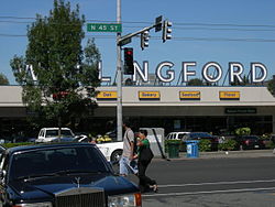
Wallingford's business district extends along N 45th Street from Stone Way N in the west to Sunnyside Avenue N in the east and features the QFC grocery store, many small shops, three banks, three pharmacies, a few taverns and bars, the Wallingford Center (the former Interlake Elementary School, now turned into shops and apartments), and numerous restaurants (including the original Dick's Drive-In, founded 1954).

Notable structures and places

Public spaces include Gas Works Park, [6] Meridian Playground, Wallingford Center shopping mall, Wallingford branch of Seattle Public Library and Wallingford playfield. Gas Works Park on Lake Union borders the Burke-Gilman Trail and provides a panoramic extension into Lake Union, with a playground in planning as part of the 2009 parks levy. The nearby North Transfer Station, a waste sorting center, was rebuilt in 2016 and includes a small park and playground. [7]

Meridian Playground features a former Roman Catholic home for wayward girls called the Good Shepherd Center, now a shared community space run by Historic Seattle. Major tenants include Tilth Alliance, Meridian School, the Wallingford Senior Center, and the Chapel performance space which features the Wayward Music Series. Wallingford playfield borders recently renovated Hamilton International Middle School and features views and a wading pool open in summer months. To the north lies Lower Woodland Park, which features athletic fields, a skate park, tennis courts, and connections to the Woodland Park Zoo and Green Lake. The University of Wallingford began in 1984, to provide religious training and Social Gospel Care to the neighborhood. It is located in the Seattle First Church of the Nazarene, behind Dick's on 45th.

Wallingford is home to several community organizations. The Wallingford Neighborhood Office, located behind Tully's (now closed—new occupant TBD on the northeast corner of Meridian Avenue N and N 45th street) helps organize local events. The Wallingford Community Council meets the first Wednesday every month in the Good Shepherd Center and engages the community with government organizations. Sustainable Wallingford is a residents group dedicated to sustainable living. Tilth Alliance runs the public gardens and plant sales at the Good Shepherd Center. Solid Ground (formerly The Fremont Public Association) is colocated with the Wallingford Branch of the Seattle Public Library and runs a food bank and family support services. The Wallingford Boys and Girls club provides a safe, social space for kids and teens along 45th, while the Wallingford Senior Center provides a safe social space for older folks. Wallingford Toastmasters is for adults of all ages and meets periodically at the Wallingford Senior Center.

Just south of N 45th is Lincoln High School. The school was re-established as a comprehensive high school in the fall of 2019 after being closed in 1981 and comprehensively renovated in 2017-2019. During the years when the high school was not operating, the school buildings were used house public schools "in exile" while their own buildings undergo major renovations the and also as the North Seattle site for Cascadia Elementary, a selective public school.

Several major motion pictures have featured scenes filmed in Wallingford, including Cinderella Liberty , Scorchy , Harry and the Hendersons , World's Greatest Dad , Singles , Say Anything... , American Heart , Class of 1999 , 10 Things I Hate About You , and Three Fugitives .

The Wallingford–Meridian Streetcar Historic District was designated by the National Register of Historic Places on December 9, 2022, to recognize the neighborhood's streetcar suburb origins. [8] The designation covers the area between Northeast 46th Street to the south, Interlake Avenue North to the west, North 50th Street to the north, and 5th Avenue Northeast to the east, which has 570 single-family homes and 66 multifamily buildings. The designation was criticized as an attempt to prevent further density in the neighborhood and preserve single-family zoning, while proponents favored protection of aesthetic and architectural features. [9]

Demographics

While the neighborhood does not have official boundaries, the area roughly corresponds to the King County Census Tracts 50, 51, and 54. While portions of Census Tract 52 would generally be considered part of Wallingford, it is not included in the demographic estimates below. [10]

As of the 2010 U.S. Census there were roughly 12,210 people living in the neighborhood. The population density was 11,411 people per square mile (4,254.4/km2), roughly 47% denser than the average density of Seattle.

The racial makeup of the neighborhood was 84.3% White, 2.2% African American, 0.4% Native American, 7.2% Asian, 0.1% Pacific Islander, 0.9% from other races, and 4.8% from two or more races. Hispanic or Latino of any race were 4.6% of the population. The neighborhood's non-white population of 15.7% is roughly half that of Seattle as a whole.

According to the 2013 American Community Survey, 40% of neighborhood units are single family homes, with the other 60% made up of apartments, condos, and townhomes. Roughly 45.4% of units were owner-occupied, compared to 54.6% managed as rental properties. 45.9% of the housing structures were built prior to 1939.

Wallingford is a relatively prosperous community. The median income for a household in 2013 was $76,909, compared to $67,479 for the city as a whole. The median home price for Wallingford was $522,366 compared to $421,000 for the city as a whole. The unemployment rate for the neighborhood was 4.2% compared to around 5.9% for 2013 for the city as a whole.

Events

Major annual events in the neighborhood include the Wallingford Kiddie Parade as part of Seafair, the Wallingford Wurst Festival run by St Benedict's Church, and the Family Fourth fireworks show at Gas Works Park. Smaller events include Seattle Tilth's chicken coop tour and the Wallingford Neighborhood office's garden and home tours.

Related Research Articles

<span class="mw-page-title-main">Haller Lake, Seattle</span>

Haller Lake is a small lake and neighborhood in north central Seattle, Washington, named for Theodore N. Haller, who platted the neighborhood in 1905. His father, Granville O. Haller, was one of Seattle's early settlers, an army officer who amassed a large estate in the region.

<span class="mw-page-title-main">Fremont, Seattle</span> Seattle Neighborhood in Washington, United States

Fremont is a neighborhood in Seattle, Washington, United States. Originally a separate city, it was annexed to Seattle in 1891. It is named after Fremont, Nebraska, the hometown of two of its founders: Luther H. Griffith and Edward Blewett.

<span class="mw-page-title-main">Ballard, Seattle</span> Seattle Neighborhood in Washington, United States

Ballard is a neighborhood in the northwestern area of Seattle, Washington, United States. Formerly an independent city, the City of Seattle's official boundaries define it as bounded to the north by Crown Hill, to the east by Greenwood, Phinney Ridge and Fremont, to the south by the Lake Washington Ship Canal, and to the west by Puget Sound's Shilshole Bay. Other neighborhood or district boundaries existed in the past; these are recognized by various Seattle City Departments, commercial or social organizations, and other Federal, State, and local government agencies.

<span class="mw-page-title-main">Green Lake, Seattle</span> Seattle Neighborhood in Washington, United States

Green Lake is a neighborhood in north central Seattle, Washington. Its centerpiece is the lake and park after which it is named.

<span class="mw-page-title-main">Queen Anne, Seattle</span> Seattle Neighborhood

Queen Anne is a neighborhood and geographic feature in Seattle, Washington, United States, located northwest of downtown. Queen Anne covers an area of 7.3 square kilometers (2.8 sq mi), and has a population of about 28,000. It is bordered by Belltown to the south, Lake Union to the east, the Lake Washington Ship Canal to the north and Interbay to the west.

<span class="mw-page-title-main">Bitter Lake, Seattle</span> Neighborhood in Seattle, Washington, United States

Bitter Lake is a neighborhood in Seattle, Washington, United States, named after its most notable feature, Bitter Lake. It was a mostly natural forest of Douglas-fir and Western Redcedar, inhabited by Native Americans, until the late 19th century. Development especially picked up when the Seattle-to-Everett Interurban streetcar reached the lake in 1906. A sawmill operated in the area until 1913, when most of the trees had been cut down.

<span class="mw-page-title-main">Phinney Ridge, Seattle</span> Seattle Neighborhood in King, Washington, United States

Phinney Ridge is a neighborhood in north central Seattle, Washington, United States. It is named after the ridge which runs north and south, separating Ballard from Green Lake, from approximately N. 45th to N. 75th Street. The ridge, in turn, is named after Guy C. Phinney, lumber mill owner and real estate developer, whose estate was bought by the city and turned into Woodland Park in 1899. Phinney's estate had included a private menagerie, and the western half of the park became what is now the Woodland Park Zoo.

<span class="mw-page-title-main">Meridian, Seattle</span>

Meridian or Tangletown is the part of Seattle's Wallingford neighborhood that lies north of N 50th Street, near Green Lake. Of note are its "K streets": Kensington, Kenwood, Keystone, and Kirkwood Places N.

<span class="mw-page-title-main">University Village, Seattle</span> Shopping mall in Washington, U.S.

University Village is a shopping mall in Seattle, Washington, United States, located in the south corner of the Ravenna neighborhood to the north of the Downtown area. It is an open-air shopping center which offers restaurants, locally owned boutiques, and national retailers, and is a popular retail destination in the region for home furnishings, popular fashions, gift items, and restaurants.

<span class="mw-page-title-main">Cascade, Seattle</span> Neighborhood in Seattle, Washington, United States

Cascade is an urban neighborhood abutting Downtown Seattle, Washington, United States, located adjacent to South Lake Union. It is bounded by: Fairview Avenue North on the west, beyond which is the rest of the Cascade Neighborhood; the Interstate 5 interchange for Mercer St to the north, beyond which is Eastlake; Interstate 5 on the east, beyond which is Capitol Hill; and Denny Way on the south, beyond which is Denny Triangle. It is surrounded by thoroughfares Mercer Street (eastbound), Fairview Avenue N. and Eastlake Avenue E., and Denny Way. The neighborhood, one of Seattle's oldest, originally extended much further: west to Terry Avenue, south to Denny Hill on the South, and east to Melrose Avenue E through the area now obliterated by Interstate 5. Some recent writers consider Cascade to omit the northern "arm", while others extend it westward to cover most of South Lake Union.

<span class="mw-page-title-main">Laurelhurst, Seattle</span>

Laurelhurst is a residential neighborhood in Seattle, Washington, US. It is bounded on the northeast by Ivanhoe Place N.E., beyond which is Windermere; on the northwest by Sand Point Way N.E. and N.E. 45th Street, beyond which are Hawthorne Hills, Ravenna, and University Village; on the west by Mary Gates Memorial Drive N.E., beyond which is the East Campus of the University of Washington; on the southwest by Union Bay; and on the east by Lake Washington. Seattle Children's Hospital is located in its northwest corner. Once a seasonal campground of the Duwamish people, the neighborhood has been a part of Seattle since its annexation in 1910.

<span class="mw-page-title-main">Bryant, Seattle</span> Seattle Neighborhood in King, Washington, United States

Bryant is a residential neighborhood in northeast Seattle, Washington. According to the City of Seattle's neighborhood maps, it is bounded by 35th Avenue NE and NE 45th Place on the west, beyond which is Ravenna; Sand Point Way NE and 45th Ave NE on the east, beyond which are Laurelhurst and Windermere; and NE 75th Street and NE 65th Street on the north, beyond which are View Ridge and Wedgwood.

<span class="mw-page-title-main">Northlake, Seattle</span>

Northlake is a neighborhood in Seattle, Washington, that consists of the southern part of Wallingford, below N 40th Street. It is so named for being on the northern shore of Lake Union. Landmarks include the Northlake Shipyard, Gas Works Park, the Wallingford Steps art installation, and Ivar's Salmon House. Circa 1900, the eastern part of Northlake was known as Latona, and the John Stanford International School building was formerly the Latona School. Nowadays, the name Latona is likely to refer to anywhere along Latona Ave. NE from Northlake north to NE 65th St. near Green Lake.

Kirkwood is a national historic designated neighborhood on the east side of Atlanta, Georgia, United States. It is a historic streetcar suburb situated entirely in DeKalb County, bordered by the neighborhoods of Lake Claire, East Lake, Edgewood, and Oakhurst. Kirkwood is bound on the north by DeKalb Avenue, on the south by Memorial Drive and Interstate 20, on the west by Montgomery Street, and on the east by 1st Ave. A large part of the neighborhood is listed on the National Register of Historic Places as Kirkwood Historic District.

<span class="mw-page-title-main">Home of the Good Shepherd</span> United States historic place

Meridian Playground is in the Wallingford neighborhood of Seattle, Washington, United States.

<span class="mw-page-title-main">Hyde Park (Austin, Texas)</span> United States historic place

Hyde Park is a neighborhood and historic district in Austin, Texas. Located in Central Austin, Hyde Park is defined by 38th Street to the south, 45th Street to the north, Duval Street to the east, and Guadalupe Street to the west. It is situated just north of the University of Texas and borders the neighborhoods of Hancock and North Loop.

The Near East Side is a neighborhood located near downtown Columbus, Ohio, made up of several neighborhoods: Mount Vernon, King-Lincoln Bronzeville, Eastgate, Franklin Park, Nelson Park, Olde Towne East, and Woodland Park.

<span class="mw-page-title-main">Westlake Avenue</span>

Westlake Avenue is a major street in Seattle, Washington, connecting Downtown Seattle to the neighborhoods of South Lake Union, Westlake and northeastern Queen Anne. The street runs north–south along the west side of Lake Union for 2.5 miles (4.0 km) from McGraw Square to the Fremont Bridge.

<span class="mw-page-title-main">North Transfer Station</span> Waste transfer station in Seattle, Washington, United States

The North Transfer Station, also known as the North Recycling and Disposal Station, is a municipal waste collection and distribution facility in Seattle, Washington, United States. It is located in the Wallingford neighborhood near Gas Works Park and is one of two transfer stations managed by Seattle Public Utilities.

References

  1. "Seattle Annexation Map". Archived from the original on 2015-11-15.
  2. 1 2 "Based on King County Census Tracts 50, 51, and 54" (PDF). Archived from the original (PDF) on 2012-07-28.
  3. "Seattle Clerk Map".
  4. "Neighborhood Plan" (PDF).
  5. "Wallingford Center" (PDF).
  6. National Trust Guide Seattle. Wiley. 1998. p. 190. ISBN   9780471180449 . Retrieved 12 September 2015.
  7. Beekman, Daniel (December 6, 2016). "Nicest dump around? New $108M transfer station in Wallingford even has a basketball court". The Seattle Times. p. A1. Retrieved February 12, 2020.
  8. "Weekly List of Actions Taken on Properties: December 9, 2022 Through December 16, 2022". National Park Service. December 16, 2022. Retrieved August 9, 2023.
  9. Groover, Heidi (October 17, 2022). "Wallingford seeks historic status; some worry it's a roadblock to density". The Seattle Times. Retrieved August 9, 2023.
  10. "Census Data" . Retrieved 2015-04-05.