South Lake Union, Seattle

Last updated
South Lake Union, Seattle
South Lake Union neighborhood from Stratus building.jpg
South Lake Union neighborhood, viewed from south of Denny Way
Nicknames: 
SLU
Seattle Map - South Lake Union.png
South Lake Union Highlighted in Pink
Coordinates: 47°37′28″N122°19′54″W / 47.62444°N 122.33167°W / 47.62444; -122.33167
CountryUnited States
State Washington
County King
City Seattle
Zip Code
98109
Area Code 206

South Lake Union (sometimes SLU [1] [2] ) is a neighborhood in Seattle, Washington, so named because it is at the southern tip of Lake Union.

Contents

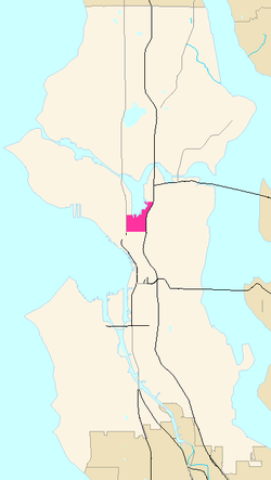
The official boundaries of the City of Seattle Urban Center are Denny Way on the south, beyond which is Denny Triangle; Interstate 5 on the east, beyond which is Capitol Hill; Aurora Avenue N. (State Route 99) on the west, beyond which is Lower Queen Anne; and Galer Street, Lake Union, and E. Newton Place on the north, beyond which are Westlake and Eastlake, [3] but like most Seattle neighborhoods, its precise boundaries are indeterminate. In particular Cornish College of the Arts and Vulcan Inc. properties such as 2200 and 2201 Westlake are officially in Denny Triangle for city planning and zoning purposes but often referred to as South Lake Union. [4] The portion of South Lake Union east of Fairview Avenue N. is historically known as Cascade. Historic structures continue to stand in the Cascade neighborhood today.

Its main thoroughfares are Valley and Mercer Streets (east- and westbound) and Dexter, 9th, Westlake, and Fairview Avenues N. and Eastlake Avenue E. (north- and southbound). The city addressed transportation issues by changing Mercer Street into a two-way, six-lane, tree-lined boulevard, with Valley Street becoming a two-way, pedestrian friendly road. [5]

History

19th century

Bow of a traditional-style kayak; Center for Wooden Boats, South Lake Union, 2007. Bow of kayak.jpg
Bow of a traditional-style kayak; Center for Wooden Boats, South Lake Union, 2007.

Lake Union is known in Chinook Jargon as Tenass Chuck ("little water", as against Lake Washington, Hyas Chuck, "big water"). It is similarly known in Duwamish as meman hartshu, "little lake". When white pioneers arrived in the 1850s, Native Americans—probably Duwamish or Southern Coast Salish—were encamped near the southwest corner of the lake and along a stream near the present-day corner of 8th and Thomas; another stream ran near Boren Avenue. There was a trail from the south end of the lake to Elliott Bay. At the time, there were deer and elk in the area; natives also ate fish, clams, root vegetables, camas, bracken, wapato and berries. Significant native settlement in South Lake Union lasted until 1875, when a windstorm knocked over a tree, destroying a longhouse in what is now Cascade. [6]

Pioneer David Denny (of the Denny Party) staked a claim in 1853. Denny's claim ran from South Lake Union (where the lake extended farther to the south and west than it does today) south to what is now Denny Way and west to include the area that is now the Seattle Center grounds. [6] In 1882, the Lake Union and Lumber Company established a sawmill (the city's largest [7] ) on the south shore of the lake, near what is now the corner of Mercer and Westlake; Denny bought it in 1884, renaming it the Western Mill. He cleared the land along the south shore of the lake and, in 1885, cut a weir from Portage Bay at the northeast corner of the lake to Lake Washington, which allowed logs to be floated to Lake Union, so that the entire area of the larger Lake Washington was a catchment for his mill. [8] [9]

Denny operated the Western Mill until 1895, and many of his employees settled nearby, some with families. During this time other mills opened in the area. In addition, the lake became a link in the transport of coal, which came from near Issaquah via Lake Washington, wagon to Portage Bay and thence to Lake Union. At first, coal was transported from South Lake Union to the downtown docks by wagon, then from 1872 to about 1877 on a narrow-gauge railroad that followed the route of present-day Westlake Avenue to Pike Street. The railroad, however, was abandoned, and the route degenerated back to a wagon trail. [8]

20th century

South Lake Union, with Lake Union Park in the center and I-5 and Eastlake in the background, as seen from the Space Needle. Southlakeunion.jpg
South Lake Union, with Lake Union Park in the center and I-5 and Eastlake in the background, as seen from the Space Needle.
Looking north on Terry Avenue N to Lake Union (2007) Seattle - Terry Ave N 02A.jpg
Looking north on Terry Avenue N to Lake Union (2007)

After David Denny's bankruptcy 1895, [7] this mill operated until the 1920s under new ownership of Brace / Hergert Mill Company. In 1909 Brace & Hergert extended their mill into the lake building a peninsula, now known as Lake Union Park. The last remaining portion of the mill business was Brace Lumber Company which operated from 1925 to 1988, the end of the mill era. The area also saw a growth in manufacturing toward the turn of the century. Cabinetry and furniture led the way in the 1890s, [10] followed by shipbuilding, Bill Boeing's first airplane factory, manufacturing seaplanes [11] and, in Cascade, Seattle City Light's Hydro House (1912) and Lake Union Steam Plant (1914) and the first Ford Model T assembly plant west of the Mississippi River (1914). [12] Both of these buildings now have landmark status. [13] The former steam plant now houses Zymogenetics [14] and the former Ford building is used for rental storage space. [15] Meanwhile, the Northern Pacific Railway ran a railroad line around Lake Union and down Terry Avenue, where a freight station opened in 1913. [12]

With industrial and commercial growth, more residential centers sprang up to house company employees and other residents. Preeminent among these residential centers was Cascade. At the center of the community established by the Russians, Swedes, Norwegians, and Greeks who settled there in the late 19th and early 20th centuries was the Cascade School (built 1894; demolished after the 1949 Olympia earthquake), a public elementary school from which the neighborhood took its name. From the 1930s, South Lake Union became less residential, evolving into an area of small business, warehouses and auto-oriented services. Cascade slowly lost its identity as a neighborhood distinct from the rest of South Lake Union, especially after construction of Interstate 5 cut it off from Capitol Hill. [16]

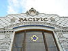
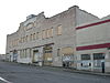
When the Lake Washington Ship Canal opened in 1917, the locks at Ballard kept Lake Union at its historic level, while the canal gave it a water connection both to Lake Washington and to Puget Sound, an arm of the Pacific Ocean. This was a further boon to industrial and commercial development. Many timber-framed buildings survive from this era, with masonry exterior walls of brick or, for some commercial buildings, terracotta. For a time, the Cascade Neighborhood held numerous automobile dealerships; the surviving Ford McKay and Pacific McKay buildings are examples. Most of the city's large laundries were in the area, especially in Cascade although the large, surviving Troy Laundry Building (1927) is immediately west of Fairview Avenue E. [17] These were soon joined by the Seattle Times Building (1930). [17]

In the early 1990s, The Seattle Times columnist John Hinterberger proposed redeveloping the area into a large green space something like New York's Central Park, loosely based on parts of Virgil Bogue's 1911 Bogue Plan. This plan became known as the Seattle Commons and evolved to include mixed-income housing, retail, and commercial space on the park edges. [18] Microsoft co-founder Paul Allen donated $20 million to buy property for the Seattle Commons, which reverted to his ownership after the proposal was defeated by public votes in 1995 and 1996. [19]

21st century

South Lake Union and downtown Seattle as seen from Lake Union Park. South Lake Union cityscape.JPG
South Lake Union and downtown Seattle as seen from Lake Union Park.
Amazon.com headquarters building in South Lake Union Amazon headquarters building Seattle.jpg
Amazon.com headquarters building in South Lake Union

Only a few of the older residential and light industrial structures of historic Cascade Neighborhood retain their original uses today; the historic Immanuel Lutheran Church and Saint Spiridon Orthodox Cathedral remain. Within the boundaries of Cascade Neighborhood as of 2008 are the REI flagship store, NBBJ architects (in the Alley24 office and apartment development built around the landmark New Richmond Laundry Building), the headquarters of PEMCO, the Fred Hutchinson Cancer Research Center and the headquarters of Zymogenetics (in the old City Light Steam Plant).

Elsewhere in South Lake Union the picture is similar. Quite a few older buildings survive, but few retain their historic uses.

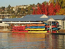
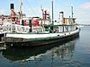
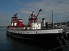
In April 2008, the new Lake Union Park opened to the public with a pedestrian bridge across the western waterway, a walkway along the waterfront, 1.6 acres (6,500 m2) of green space, landscaping and much more. The 12-acre (49,000 m2) park was completed in 2010. The historic ships wharf provides long-term moorage for historic vessels; and the Maritime Heritage Center will provide an array of cultural, educational, and recreational activities. Vessels currently moored at the wharf include the steamer Virginia V , [20] the lightship Swiftsure , the tug Arthur Foss , the fireboat Duwamish , and the salmon troller Twilight. The schooner Wawona was also moored nearby at Northwest Seaport until it was dismantled in 2009. Several smaller historic boats are just to the east at the Center for Wooden Boats.

In December 2007, Amazon announced it would be consolidating its Seattle offices in South Lake Union; occupancy began in 2010. [21]

Opened in December 2012, the Museum of History & Industry relocated from Seattle's Montlake neighborhood to the former Naval Reserve Training Center, or "Armory." [22]

South Lake Union is also home to Denny Park, the oldest park in the city.

South Lake Union (center) is separated from Capitol Hill (right) by Interstate 5. South lake union panorama night.jpg
South Lake Union (center) is separated from Capitol Hill (right) by Interstate 5.

Future as a hub for life sciences

Due to recent development plans by Paul Allen's Vulcan Inc., as well as other prominent developers, South Lake Union is becoming a hub for life science organizations. Some in the area include: Fred Hutchinson Cancer Research Center, the Allen Institute for Brain Science, the Allen Institute for Cell Science, Zymogenetics, Battelle, Seattle Biomedical Research Institute, Seattle Children's Hospital, PATH, Rosetta (now part of Merck & Co.), Bio-Rad, and University of Washington Medicine.

The South Lake Union Campus of the University of Washington School of Medicine now includes 1250 people (researchers and staff) in four buildings. [23] The oldest is the Brotman Building (the former home of Washington Natural Gas, when it was known as the "Blue Flame building") at 815 Mercer St, which houses 4 floors of biotechnology and medical research laboratories. Among the varied research areas are four Centers, focused on Allergy & Inflammation, Cardiovascular Biology & Regenerative Medicine, Lung Biology and Translational Medicine in Women's Health.

The plan for development of a biotechnology hub in South Lake Union has been somewhat controversial, as it is seen by some as an example of influential private companies receiving benefits from the city. There were early worries that formerly affordable housing would be destroyed and not replaced. The non-profit Low-Income Housing Institute (LIHI) now has 5 buildings in the Cascade Neighborhood and Denny Triangle. [24] Vulcan Real Estate opened the work-force Borealis Apartments on May 20, 2008. [25] Alley24 has 20% of its units set aside for those earning less than 60% of the median income. Additionally, Seattle's Office of Housing began construction of the affordable Cascade Senior Housing in July 2008. [26]

In 2007, the South Lake Union Streetcar began operation, connecting Westlake Center to the south end of Lake Union at Yale Avenue N., near the Cascade Neighborhood, and Fred Hutchinson Cancer Research Center.

Housing

Kayaks in storage in South Lake Union Lakeunionkayaks.JPG
Kayaks in storage in South Lake Union

In early Seattle history, South Lake Union had housing for both workers and owners of mills on Lake Union, including David Denny's residence at Dexter Ave N and Republican St. [27] By the 1960s, landowners including the Seattle Times demolished acres of housing for parking lots, leaving the Cascade Neighborhood as the only district with many residential options. [28] As early as 1972, the mayor's "In-City Living Task Force" proposed the creation of 50,000 housing units in high-rise apartments in South Lake Union and Belltown. [29] Since an economic redevelopment was initiated by the City Council in 2003, South Lake Union has seen a marked increase in housing with 1,850 new units, or 2,000,000 square feet (190,000 m2) of housing, either completed or scheduled to be completed by the end of 2008. [30] [ needs update ] While most of the additional housing is market-rate, community affordable housing advocates succeeded in requiring a significant number of units for "the [formerly] homeless, low-income and mentally ill." [31]

Economy

Jones Soda Company used to have its headquarters in South Lake Union. [32] [33] Amazon has over 25 buildings and thousands of employees in its SLU campus with more in the adjacent Denny Triangle neighborhood.

In October 2012, Amazon announced it would spend over $1 billion to purchase its South Lake Union corporate headquarters from Microsoft founder Paul Allen's investment firm. Based on the value of the deal, Amazon would pay the highest ever price for an office building over 100,000 square feet in Seattle at around $644 per square foot, more than double the then-current average rate of $308 per square foot for the city's office space, according to Real Capital Analytics. [34]

In the 2010s, both Google and Facebook opened offices in South Lake Union. [35]

Green space

Landmarks and historic sites

For landmarks and historic sites in Cascade (using the city's current official definition of that neighborhood) see Cascade, Seattle. With the exception of the Pacific McKay and Ford McKay buildings and the boats at Northwest Seaport, all of these landmarks fall within the maximum extent of Cascade, as the neighborhood was understood in the early 20th century. [36]

Building or
structure
AddressListingPhoto
Tugboat Arthur Foss Officially listed in Kirkland, Washington but now
docks at Northwest Seaport, Lake Union Park
NRHP Tugboat Arthur Foss 04.jpg
Excursion Boat Virginia V Docks at Northwest Seaport, Lake Union Park Seattle landmark
NRHP
Virginia V 01.jpg
Fireboat Duwamish Docks at Northwest Seaport, Lake Union Park Seattle landmark
NRHP
Fireboat Duwamish 01.jpg
Lightship Relief / Swiftsure Docks at Northwest Seaport, Lake Union Park Seattle landmark
|NRHP
Swiftsure 01.jpg
Pacific McKay and Ford McKay buildings601-15 Westlake Ave. N Seattle landmark Seattle - Pacific McKay building 03.jpg
R-class sloop Pirate Docks at Center for Wooden Boats NRHP
R-class sloop Pirate 01.jpg
Schooner Wawona
No longer seaworthy
Dismantled in 2009. Seattle landmark
NRHP
Wawona 01A.jpg
Seattle First National Bank Building566 Denny Way Seattle landmark Seattle - former SeaFirst on Denny 01.jpg
Seattle Times Building 1120 John St. Seattle landmark Seattle Times Building 05.jpg
Troy Laundry Building
As of 2008, used by the Seattle Times as a warehouse
311–329 Fairview Ave. N Seattle landmark Seattle - Troy Laundry Building 01.jpg
Van Vorst Building 413–421 Boren Ave. N Seattle landmark Seattle - 415 Boren Ave N 03.jpg
West Earth Co. Street Clock 406 Dexter Ave. N Seattle landmark  
William Volker Building
Now part of Cornish College of the Arts
1000 Lenora Street NRHP Seattle - Cornish - 1000 Lenora 01.jpg
Schooner Zodiac Home port is now in Bellingham, Washington, but often
docks at the Center for Wooden Boats
NRHP Schooner Zodiac 03.jpg

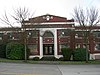
Raisbeck Performance Hall, a former Sons of Norway hall, is now part of Cornish College of the Arts. It sits just south of Denny Way near the William Volker Building (see list above, which is also part of Cornish. Hence, it is officially just outside South Lake Union.

Building or
structure
AddressListingPhoto
Old Norway Hall
Now Raisbeck Performance Hall
2015 Boren Ave. Seattle landmark  
Naval Reserve Armory
(Museum of History and Industry since 2013)
800 Terry Ave. N. Seattle landmark South Lake Union Naval Reserve Building 04.jpg

Related Research Articles

<span class="mw-page-title-main">Pioneer Square, Seattle</span> United States historic place

Pioneer Square is a neighborhood in the southwest corner of Downtown Seattle, Washington, US. It was once the heart of the city: Seattle's founders settled there in 1852, following a brief six-month settlement at Alki Point on the far side of Elliott Bay. The early structures in the neighborhood were mostly wooden, and nearly all burned in the Great Seattle Fire of 1889. By the end of 1890, dozens of brick and stone buildings had been erected in their stead; to this day, the architectural character of the neighborhood derives from these late 19th century buildings, mostly examples of Richardsonian Romanesque.

<span class="mw-page-title-main">Belltown, Seattle</span> Most densely populated neighborhood in Seattle, Washington

Belltown is the most densely populated neighborhood in Seattle, Washington, United States, located on the city's downtown waterfront on land that was artificially flattened as part of a regrading project. Formerly a low-rent, semi-industrial arts district, in recent decades it has transformed into a neighborhood of trendy restaurants, boutiques, nightclubs, and residential towers as well as warehouses and art galleries. The area is named after William Nathaniel Bell, on whose land claim the neighborhood was built.

<span class="mw-page-title-main">Downtown Seattle</span> Central business district of Seattle, Washington, U.S.

Downtown is the central business district of Seattle, Washington. It is fairly compact compared with other city centers on the U.S. West Coast due to its geographical situation, being hemmed in on the north and east by hills, on the west by Elliott Bay, and on the south by reclaimed land that was once tidal flats. It is bounded on the north by Denny Way, beyond which are Lower Queen Anne, Seattle Center, and South Lake Union; on the east by Interstate 5, beyond which is Capitol Hill to the northeast and Central District to the east; on the south by S Dearborn Street, beyond which is Sodo; and on the west by Elliott Bay, a part of Puget Sound.

<span class="mw-page-title-main">Columbia City, Seattle</span> Seattle Neighborhood in Washington, United States

Columbia City is a neighborhood located in the southeastern part of Seattle, Washington in the Rainier Valley district. It has a landmark-protected historic business district and is one of the few Seattle neighborhoods with a long history of ethnic and income diversity.

<span class="mw-page-title-main">Denny Triangle, Seattle</span> Neighborhood in Seattle

The Denny Triangle is a neighborhood in Seattle, Washington, United States, that stretches north of Downtown Seattle to the grounds of Seattle Center. Its generally flat terrain was originally a steep hill, taken down as part of a mammoth construction project in the first decades of the 20th century known as the Denny Regrade, which is another name for the neighborhood on the regraded area. The name Denny Triangle, referring to the northeastern portion of this regrading project, is a term that has gained currency as this neighborhood has seen increasing development in the first decades of the 21st Century.

<span class="mw-page-title-main">Queen Anne, Seattle</span> Seattle Neighborhood

Queen Anne is a neighborhood and geographic feature in Seattle, Washington, United States, located northwest of downtown. Queen Anne covers an area of 7.3 square kilometers (2.8 sq mi), and has a population of about 28,000. It is bordered by Belltown to the south, Lake Union to the east, the Lake Washington Ship Canal to the north and Interbay to the west.

<span class="mw-page-title-main">Cascade, Seattle</span> Neighborhood in Seattle, Washington, United States

Cascade is an urban neighborhood abutting Downtown Seattle, Washington, United States, located adjacent to South Lake Union. It is bounded by: Fairview Avenue North on the west, beyond which is the rest of the Cascade Neighborhood; the Interstate 5 interchange for Mercer St to the north, beyond which is Eastlake; Interstate 5 on the east, beyond which is Capitol Hill; and Denny Way on the south, beyond which is Denny Triangle. It is surrounded by thoroughfares Mercer Street (eastbound), Fairview Avenue N. and Eastlake Avenue E., and Denny Way. The neighborhood, one of Seattle's oldest, originally extended much further: west to Terry Avenue, south to Denny Hill on the South, and east to Melrose Avenue E through the area now obliterated by Interstate 5. Some recent writers consider Cascade to omit the northern "arm", while others extend it westward to cover most of South Lake Union.

<span class="mw-page-title-main">Westlake Park (Seattle)</span>

Westlake Park is a 0.1-acre (400 m2) public plaza in downtown Seattle, Washington, United States. It was designed by Robert Mitchell Hanna.

<span class="mw-page-title-main">South Lake Union Streetcar</span> Streetcar line in Seattle, Washington

The South Lake Union Streetcar, officially the South Lake Union Line, is a streetcar route in Seattle, Washington, United States, forming part of the Seattle Streetcar system. It travels 1.3 miles (2.1 km) and connects Downtown Seattle to the South Lake Union neighborhood on Westlake Avenue, Terry Avenue, and Valley Street. The South Lake Union Streetcar was the first modern line to operate in Seattle, beginning service on December 12, 2007, two years after a separate heritage streetcar ceased operations.

<span class="mw-page-title-main">David Denny</span> American judge

David Thomas Denny was a member of the Denny Party, who are generally collectively credited as the founders of Seattle, Washington, USA. Though he ultimately underwent bankruptcy, he was a significant contributor to the shape of the city. Roger Sale, in his book Seattle, Past to Present, described him as having been "the pioneer to turn to if one had a plan that would be 'good for Seattle', and one needed a respectable tone and a willing investor."

<span class="mw-page-title-main">Pike Place Market</span> Public market and tourist attraction in Seattle, Washington

Pike Place Market is a public market in Seattle, Washington, United States. It opened on August 17, 1907, and is one of the oldest continuously operated public farmers' markets in the United States. Overlooking the Elliott Bay waterfront on Puget Sound, it serves as a place of business for many small farmers, craftspeople and merchants. It is named for its central street, Pike Place, which runs northwest from Pike Street to Virginia Street on the western edge of Downtown Seattle. Pike Place Market is Seattle's most popular tourist destination and the 33rd most visited tourist attraction in the world, with more than 10 million annual visitors.

<span class="mw-page-title-main">Central Waterfront, Seattle</span> Neighborhood in Seattle

The Central Waterfront of Seattle, Washington, United States, is the most urbanized portion of the Elliott Bay shore. It runs from the Pioneer Square shore roughly northwest past Downtown Seattle and Belltown, ending at the Broad Street site of the Olympic Sculpture Park.

<span class="mw-page-title-main">McGraw Square</span> Plaza in Seattle, Washington, U.S.

McGraw Square is a small plaza and streetcar stop in the Denny Triangle neighborhood of Seattle, Washington. The 0.01-acre (0.0040 ha) park, one of the smallest in the city park system, is named for and features a statue of former King County Sheriff and Governor of Washington John Harte McGraw. McGraw Square is bounded to the north by Stewart Street, to the west by 5th Avenue and the Times Square Building, and to the east by Olive Way and the Medical Dental Building.

<span class="mw-page-title-main">Architecture of Seattle</span> Overview of the architecture in Seattle

The architecture of Seattle, Washington, the largest city in the Pacific Northwest region of the U.S., features elements that predate the arrival of the area's first settlers of European ancestry in the mid-19th century, and has reflected and influenced numerous architectural styles over time. As of the early 21st century, a major construction boom continues to redefine the city's downtown area as well as neighborhoods such as Capitol Hill, Ballard and, perhaps most dramatically, South Lake Union.

<span class="mw-page-title-main">Denny Substation</span> Electrical substation in Seattle, Washington

The Denny Substation is an electrical substation located in the South Lake Union neighborhood of Seattle, Washington, and operated by Seattle City Light. The facility takes up a whole city block along Denny Way and features a community center, interpretive exhibits, a dog park, and public art.

<span class="mw-page-title-main">1120 Denny Way</span> Complex of two high-rise residential buildings under construction in Lake Union, Seattle

1120 Denny Way is a complex of two high-rise residential buildings that are under construction in South Lake Union, Seattle, Washington, United States. The buildings will both be 41 stories tall, with a total of 1,179 apartments, and connected by a 12-story podium with retail and amenity space. 1120 Denny Way is being developed by Onni Group, which is also redeveloping the adjacent Seattle Times Building site. The project began construction in 2017 and is planned to be completed in 2022.

<span class="mw-page-title-main">Pike Street</span> Street in Seattle

Pike Street is an east-west street in Seattle. It extends from Pike Place above Seattle's saltwater waterfront at Elliott Bay through Downtown Seattle, across Capitol Hill to the freshwater shore of Lake Washington at Lake Washington Boulevard. A segment less than a block long exists at Alaskan Way on Elliott Bay, connected to the rest of the street only by the pedestrian Pike Street Hill Climb; the bottom of the hillclimb under the Alaskan Way Viaduct was the original shoreline of the city before major modification and construction of the Seattle Seawall. It is included in the south-to-north mnemonic "Jesus Christ Made Seattle Under Protest" for the street layout of Seattle.

Denny Way is an east–west arterial street in downtown Seattle, Washington, United States. It forms the northern end of the Belltown street grid as well as the boundaries of Belltown, Lower Queen Anne, South Lake Union, Denny Triangle, and Cascade. The street continues east through Capitol Hill to Madrona as a minor neighborhood street, ending near Madrona Park on Lake Washington.

<span class="mw-page-title-main">Westlake Avenue</span>

Westlake Avenue is a major street in Seattle, Washington, connecting Downtown Seattle to the neighborhoods of South Lake Union, Westlake and northeastern Queen Anne. The street runs north–south along the west side of Lake Union for 2.5 miles (4.0 km) from McGraw Square to the Fremont Bridge.

References

  1. Adriana Grant, Portage Bay Cafe to Open a Second Location in SLU Archived 2011-07-24 at the Wayback Machine , Voracious (Seattle Weekly food blog), April 7, 2008. Accessed online 8 December 2008.
  2. The SLU story Archived 2011-07-17 at the Wayback Machine , Vulcan Real Estate. Accessed online 8 December 2008.
  3. Seattle Department of Planning and Development, South Lake Union Neighborhood Plan Archived 2010-06-07 at the Wayback Machine
  4. Pryne, Eric (2010-04-29). "Federal agencies moving in". Seattle Times. Retrieved May 2, 2010.
  5. Seattle Department of Transportation, Mercer Corridor Project
  6. 1 2 James R. Warren, 10 Who Shaped Seattle: David Denny beat founders to Elliott Bay, Seattle Post-Intelligencer, November 13, 2001
  7. Fiset 2001
  8. Link 2004 , p. 7
  9. Link 2004 , p. 10
  10. Landmarks Alphabetical Listing for F Archived 2011-07-21 at the Wayback Machine and Landmarks Alphabetical Listing for L Archived 2011-07-21 at the Wayback Machine , Individual Landmarks, Seattle Department of Neighborhoods. Accessed online 9 February 2008.
  11. ZymoGenetics' Steam Plant Facility: A Brief History Archived 2008-05-09 at the Wayback Machine . Accessed online 9 February 2008.
  12. Point 5: Ford Motor Company Assembly Plant (John Graham Sr., 1913) 700 Fairview Avenue N [ permanent dead link ], HistoryLink Cybertour of Lake Union. Accessed online 9 February 2008.
  13. Link 2004, passim. More specific citations can be found in the article Cascade, Seattle, Washington .
  14. Gerry Johnson, Strategy For South Lake Union – Seattle Commons: More Than A Park – City Has Unprecedented Opportunity To Respond To Some Crucial Needs, Seattle Times, January 10, 1993. Accessed online 28 May 2011.
  15. Paula Becker, Seattle voters reject the Seattle Commons levy on September 19, 1995. HistoryLink, August 08, 2007. Accessed online 28 May 2011.
  16. Virginia V, official site.
  17. Eric Pryne, Amazon will move headquarters to S. Lake Union complex, Seattle Times, December 21, 2007. Accessed online 5 February 2008.
  18. "Museum of History & Industry (MOHAI)". www.historylink.org. Retrieved May 25, 2020.
  19. "UW Medicine opens South Lake Union complex". Accessed online 3 June 2008.
  20. "Seattle LIHI Properties" Archived 2008-07-08 at the Wayback Machine . Accessed online 15 July 2008.
  21. "Vulcan Opens New Affordable Housing Development" Archived 2011-07-17 at the Wayback Machine . Accessed online 15 July 2008.
  22. "Groundbreaking Ceremony for Cascade Senior Housing" Archived 2011-07-17 at the Wayback Machine . Accessed online 15 July 2008.
  23. Augustus Koch (1891). "Birds-eye-view of Seattle and environs King County, Wash., 1891". Hughes Litho. Co. Retrieved 2010-03-02.
  24. Louis Fiset (2001-04-09). "Cascade and South Lake Union – Thumbnail History". HistoryLink.org. Retrieved 2010-03-02.
  25. Jones, Nard (1972). Seattle. Doubleday. p. 21. ISBN   0-385-01875-4.
  26. Joseph Tartakoff (2007-11-27). "South Lake Union is booming". Seattle Post-Intelligencer. Retrieved 2007-11-30.
  27. Bob Young (2008-02-10). "New, Improved South Lake Union". Seattle Times. Retrieved 2010-03-02.
  28. "Contact Us Archived 2011-03-03 at the Wayback Machine ." Jones Soda. Retrieved on February 12, 2010.
  29. Allison, Melissa. "Jones Soda eyes mainstream soda market." The Seattle Times . Thursday May 15, 2008. Retrieved on February 12, 2010. "...Jones said last week at the company's South Lake Union headquarters."
  30. "." Reuters. Retrieved on October 6, 2012.
  31. "Take a look inside Google's unusual new office, the first building on its South Lake Union campus". The Seattle Times. 2019-10-03. Retrieved 2020-04-18.
  32. History, Organizational Description, Boundaries, Cascade Neighborhood Council, November 1997. Accessed 3 February 2008.

Further reading

Parks and museums