Pierce County is a county in the U.S. state of Washington. As of the 2020 census, the population was 921,130, up from 795,225 in 2010, making it the second-most populous county in Washington, behind King County, and the 59th-most populous in the United States. The county seat and largest city is Tacoma. Formed out of Thurston County on December 22, 1852, by the legislature of Oregon Territory, it was named for U.S. President Franklin Pierce. Pierce County is in the Seattle metropolitan area.

Fremont is a neighborhood in the North Central District of Seattle, Washington, United States. Originally a separate city, it was annexed to Seattle in 1891. It is named after Fremont, Nebraska, the hometown of two of its founders: Luther H. Griffith and Edward Blewett.

Wallingford is a neighborhood in north central Seattle, lying on a hill above the north shore of Lake Union about four miles from the downtown core. The neighborhood developed quickly during the early 20th century after the establishment of the University of Washington to the east. With trolley tracks laid through the neighborhood as early as 1907, Wallingford is a classic streetcar suburb, typified by its many 1920s era box houses and bungalows. Commercial development is primarily concentrated along North 45th Street where a number of iconic structures stand including the neon "WALLINGFORD" sign, the Wallingford Center, and the original Dick's Drive-In. With its central location, numerous public amenities, including the Gas Works Park, and views of both the Olympic and Cascade mountains, Wallingford has long been home to many middle and upper-class families. While Wallingford is mostly residential in nature, the neighborhood's southern edge, along Lake Union, has historically been an industrial and commercial business strip. In recent years, numerous office buildings have been developed as an extension of the burgeoning business center in neighboring Fremont. In 2014 Brooks Sports moved its headquarters from Bothell to a new six-story office building at the southwestern edge of Wallingford.

Queen Anne is a neighborhood in northwestern Seattle, Washington. Queen Anne covers an area of 7.3 square kilometers (2.8 sq mi), and has a population of about 28,000. It is bordered by Belltown to the south, Lake Union to the east, the Lake Washington Ship Canal to the north and Interbay to the west.

Chief Leschi was a chief of the Nisqually Indian Tribe of southern Puget Sound, Washington, primarily in the area of the Nisqually River.

Madison Park is an 8.3 acre (34,000 m2) park in the Madison Park neighborhood of Seattle, Washington, located between the western shore of Lake Washington on the east, 42nd Avenue E. on the west, E. Madison Street on the north, and E. Blaine Street on the south. 43rd Avenue E. divides it into two sections; the east is a swimming beach and public dock, and the west is a playground, playfield, and tennis courts. Next to the beach is Madison Park Co-op, a community playhouse for toddlers and children.

Leschi Park is an 18.5 acres (75,000 m2) park in the Leschi neighborhood of Seattle, Washington, named after Chief Leschi of the Nisqually tribe. The majority of the park is a grassy hillside that lies west of Lakeside Avenue S. and features tennis courts, picnic tables, and a playground. Across Lakeside Avenue to the east is the western shore of Lake Washington and a small lawn with benches. To its south is the southern portion of Leschi Moorage, separated from the northern portion by a parking lot in the E. Yesler Way right-of-way, private docks, and an office/restaurant complex.

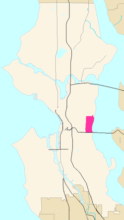
Frink Park is a 17.2 acre park in the Leschi neighborhood of Seattle, Washington. It is a heavily wooded hillside and ravine through which flows Frink Creek. Most of the park is bounded by 31st Avenue S. in the west, 34th Avenue S. in the east, and the rights-of-way of S. Main Street in the north and S. King Street in the south. Lake Washington Boulevard S. and S. Frink Place are recreational drives within the park.

Lake City is a neighborhood and the northeast region of Seattle, centered along Lake City Way NE (SR-522), 7–8 miles (11–13 km) northeast of downtown Seattle. A broader definition of the Lake City area includes all the land between 15th Avenue NE and Lake Washington, and between NE 95th and 98th streets to the Seattle city limits at NE 145th Street. Lake City encompasses much of the Thornton Creek watershed, the focus of a long restoration campaign by citizens and Seattle Public Utilities staff to enhance the residential environment of Lake City.

Madrona is a mostly residential neighborhood in east Seattle, Washington. It is bounded on the east by Lake Washington; on the south by E. Cherry Street, beyond which is Leschi; on the west by Martin Luther King Jr. Way, beyond which is the Central District; and on the north by E. Howell Street, beyond which is Denny-Blaine.

Mount Baker is a neighborhood in southeastern Seattle, Washington. The neighborhood's name comes from the view of Mount Baker in Whatcom County, that is seen by looking north over Lake Washington. It is bounded by Lake Washington to the east, Interstate 90 and then Leschi to the north, Rainier Valley to the west, and Columbia City to the south. The neighborhood has a community club and a rowing team. It hosts Seattle's annual Seafair, which includes an airshow featuring the U.S. Navy Blue Angels, hydroplane races, a fireworks show, and other festivities. Franklin High School and Garfield High School serve this area. It is part of Seattle's South End.

Matthews Beach is a neighborhood in Seattle, Washington; it and Meadowbrook are the southern neighborhoods of the annexed township of Lake City (1954). Matthews Beach lies about 2 miles (3.2 km) northeast of the University of Washington, about 8 miles (13 km) northeast of Downtown.

The Puget Sound War was an armed conflict that took place in the Puget Sound area of the state of Washington in 1855–56, between the United States military, local militias and members of the Native American tribes of the Nisqually, Muckleshoot, Puyallup, and Klickitat. Another component of the war, however, were raiders from the Haida and Tlingit who came into conflict with the United States Navy during contemporaneous raids on the native peoples of Puget Sound. Although limited in its magnitude, territorial impact and losses in terms of lives, the conflict is often remembered in connection to the 1856 Battle of Seattle and to the execution of a central figure of the war, Nisqually Chief Leschi. The contemporaneous Yakima War may have been responsible for some events of the Puget Sound War, such as the Battle of Seattle, and it is not clear that the people of the time made a strong distinction between the two conflicts.

Meadowbrook is a neighborhood in the Lake City district of Seattle, Washington. Meadowbrook is centered on open fields adjacent to the Community Center, Meadowbrook swimming pool, and Nathan Hale High School. It is bounded on the south by NE 95th Street and the Wedgwood neighborhood, on the north by NE 120th Street and Cedar Park, on the west by Lake City Way NE and Victory Heights, and on the east by 35th Avenue NE and Matthews Beach.

North Admiral is the oldest neighborhood in West Seattle, Washington. In the early 1900s, it was connected to Seattle by ferries and a cable car. These ferries included the paddle steamers City of Seattle and West Seattle.

Lake Washington Boulevard is a scenic, approximately 8-mile (13 km), road through Seattle, Washington, that hugs Lake Washington for much of the route. There are views of the lake, small sections of rainforest, meadows, and views of the Cascade mountains. At its northern end, Lake Washington Boulevard originates as East Lake Washington Boulevard at Montlake Boulevard East, soon becomes Lake Washington Boulevard East, and runs through the length of the Washington Park Arboretum. The road begins at S. Juneau Street in Seward Park, running thence along the lake to Colman Park, just south of Interstate 90. From here north to E. Alder Street in Leschi, the lakeside road is named Lakeside Avenue, and Lake Washington Boulevard diverts to a winding route through Colman, Frink, and Leschi Parks. At E. Alder, the boulevard once again runs along the lake through Madrona Park to just north of Madrona Drive, where private residences occupy the shore. At E. Denny-Blaine Place, the road heads northwest, through Lakeview Park and the grounds of The Bush School, to the south entrance of the Arboretum at E. Madison Street. It continues through the Arboretum. Just north of E. Roanoke Street, the boulevard turns due west and changes from Lake Washington Boulevard E. to E. Lake Washington Boulevard, following the city's street name designation system. The boulevard ends at the Montlake overpass of 520, where E. Montlake Place E. becomes Montlake Boulevard E.
Pinehurst is a neighborhood in the Northgate area of Seattle, Washington, United States. It is bounded by NE 145th Street to the north, NE Northgate Way to the south, I-5 to the west, and Lake City Way to the east. These boundaries were determined by the Pinehurst Community Council. Pinehurst's northern boundary of NE 145th Street makes Pinehurst one of the northernmost neighborhoods in the city of Seattle.
Powell S. Barnett was a Seattle-based musician, civil rights activist, and African American community leader.

Flo Ware Park is a public park in Seattles Central District / Leschi neighborhoods, in the U.S. state of Washington. It was named for Flo Ware in 1982.