Related Research Articles

Windermere is a residential neighborhood in northeastern Seattle, Washington, named after Windermere in England's Lake District. It is bounded on the north by Magnuson Park, part of Sand Point; on the northwest by Sand Point Way N.E., beyond which is Hawthorne Hills; on the southwest by Ivanhoe Place N.E., beyond which is Laurelhurst; and on the southeast by Lake Washington. The area has been a part of Seattle since 1910.

The Ward House is a house on Capitol Hill in Seattle, Washington, USA. Having been built in 1882, it is one of the oldest houses in Seattle. Existing houses reportedly built before 1882 in Seattle include the 2629 East Aloha Street (1881), 727 28th Avenue (1870) and Maynard's House located at 3045 64th Avenue Southwest.
Lower Queen Anne is a neighborhood in northwestern Seattle, Washington, at the base of Queen Anne Hill. While its boundaries are not precise, the toponym usually refers to the shopping, office, and residential districts to the north and west of Seattle Center. The neighborhood is connected to Upper Queen Anne—the shopping district at the top of the hill—by an extremely steep section of Queen Anne Avenue N. known as the Counterbalance, in memory of the cable cars that once ran up and down it.

Madison Park is a neighborhood in eastern Seattle, Washington, United States. It is named after the city park at the foot of Madison Street on the Lake Washington shore. The neighborhood is generally bounded on the east by Lake Washington; on the south by East Prospect Street, beyond which is Denny-Blaine; on the west by Lake Washington Boulevard E.; and on the north by Union Bay. Madison Park generally consists of single-family housing with a small business district near the park.

Mount Baker is a neighborhood in southeastern Seattle, Washington. The neighborhood's name comes from the view of Mount Baker in Whatcom County, that is seen by looking north over Lake Washington. It is bounded by Lake Washington to the east, Interstate 90 and then Leschi to the north, Rainier Valley to the west, and Columbia City to the south. The neighborhood has a community club and a rowing team. It hosts Seattle's annual Seafair, which includes an airshow featuring the U.S. Navy Blue Angels, hydroplane races, a fireworks show, and other festivities. Franklin High School and Garfield High School serve this area. It is part of Seattle's South End.

Crown Hill is a neighborhood in the city of Seattle, in the U.S. state of Washington.
Dunlap is a neighborhood in southern Seattle, Washington, just north of Rainier Beach. It is home to Dunlap Elementary School, part of the Seattle Public Schools. Dunlap is named after Joseph Dunlap, the first homesteader in the area.
North Beach / Blue Ridge is a neighborhood in the city of Seattle, in the U.S. state of Washington.

Squire Park is a neighborhood in the city of Seattle, in the U.S. state of Washington. According to the Squire Park Community Council, it is bounded on the south by S. Jackson Street, on the west by 12th Avenue and 12th Avenue S., on the north by E. Union Street, and on the east by 23rd Avenue and 23rd Avenue S., placing it within the Central District. Its main thoroughfares are E. Jefferson and Cherry Streets and E. Yesler Way and 14th Avenue. Swedish Medical Center's Cherry Hill campus is located here, Seattle University, a Jesuit University has part of its campus in Squire Park, as the Admissions, some dormitories and Athletics departments are east of 12th Avenue.

Westlake is a neighborhood in Seattle, Washington. It was named after its location on the western shore of Lake Union. It is a relatively narrow neighborhood, there being only a few blocks between the shoreline and its western limit at Aurora Avenue N., beyond which is Queen Anne. To the south beyond Aloha Street is South Lake Union, and to the north across the Fremont Cut is Fremont. Its main thoroughfares are Dexter and Westlake Avenues N..
The Fairmount Park is a neighborhood of West Seattle in Seattle, Washington. It runs southwest along both sides of Fauntleroy Way, from SW Graham Street in the south to SW Edmunds Street in the north. Neighborhood features include Fairmount Playfield, a city park, and Fairmount Park Elementary School, part of the Seattle Public Schools system.
Victory Heights is a neighborhood in the Lake City district of Seattle, Washington. It was named after the Victory Highway, which formed the eastern border of the area. The highway was originally called the Gerhart Erickson Road, the namesake of which was Gerhart Erickson, who sponsored the Good Roads legislation in 1903. The road was then renamed Bothell Road, changed to Victory Highway in 1924, before returning to Bothell Road; it is now called Lake City Way NE. The neighborhood was annexed to the city of Seattle in 1954.
Brighton is a primarily residential neighborhood in southern Seattle, Washington, part of the greater Rainier Valley district and centered about a mile and a half south of the Columbia City neighborhood.
Genesee is a neighborhood of West Seattle in Seattle, Washington. It extends north from SW Genesee St. to SW Charlestown St., and west from 46th to 56th Avenues SW. The neighborhood includes Ercolini Park and the new Genesee Hill Elementary School. It should not be confused with Genesee Park, in Rainier Valley.

Seaview is a neighborhood in West Seattle, Washington. Seaview is bordered by Puget Sound to the west, the Alki and Genesee neighborhoods to the north, Fairmount Park to the east, and Gatewood to the south.
Pinehurst is a neighborhood in the Northgate area of Seattle, Washington, United States. It is bounded by NE 145th Street to the north, NE Northgate Way to the south, I-5 to the west, and Lake City Way to the east. These boundaries were determined by the Pinehurst Community Council. Pinehurst's northern boundary of NE 145th Street makes Pinehurst one of the northernmost neighborhoods in the city of Seattle.
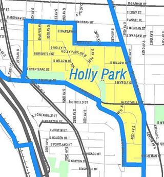
NewHolly is a neighborhood in southeastern Seattle, Washington, United States. It is part of Seattle's South End.

Loyal Heights is a neighborhood in Seattle, Washington. It is considered part of greater Ballard.

Briarcliff is a neighborhood in Seattle, Washington. The city's Department of Neighborhoods places Briarcliff on the west side of Magnolia, south of Discovery Park.
West Woodland is a neighborhood in Seattle, Washington. The city's Department of Neighborhoods places West Woodland in the south east corner of Ballard.
References
- ↑ "Seattle City Clerk's Geographic Indexing Atlas". seattle.gov. City of Seattle . Retrieved September 27, 2017.
47°37′35.74″N122°19′19.32″W / 47.6265944°N 122.3220333°W
| | This King County, Washington state location article is a stub. You can help Wikipedia by expanding it. |