
The street layout of Seattle is based on a series of disjointed rectangular street grids. Most of Seattle and King County use a single street grid, oriented on true north. Near the center of the city, various land claims were platted in the 19th century with differently oriented grids, which still survive today. Distinctly oriented grids also exist in some cities annexed by Seattle in the early 20th century, such as Ballard and Georgetown. A small number of streets and roads are exceptions to the grid pattern.

The Downtown Seattle Transit Tunnel (DSTT), also referred to as the Metro Bus Tunnel, is a 1.3-mile-long (2.1 km) pair of public transit tunnels in Seattle, Washington, United States. The double-track tunnel and its four stations serve Link light rail trains on the 1 Line as it travels through Downtown Seattle. It runs west under Pine Street from 9th Avenue to 3rd Avenue, and south under 3rd Avenue to South Jackson Street. 1 Line trains continue north from the tunnel to Northgate station and south through the Rainier Valley past Seattle–Tacoma International Airport to Angle Lake station as part of Sound Transit's light rail network.

The Waterfront Streetcar, officially the George Benson Waterfront Streetcar Line, was a heritage streetcar line run by King County Metro in Seattle, Washington, United States. It traveled for 1.6-mile (2.6 km) along Alaskan Way on the city's waterfront facing Elliott Bay, under the Alaskan Way Viaduct. The Waterfront Streetcar used a fleet of five W2 trams from Melbourne, Australia.

King County Metro, officially the King County Metro Transit Department and often shortened to Metro, is the public transit authority of King County, Washington, which includes the city of Seattle. It is the eighth-largest transit bus agency in the United States. In 2023, the system had a ridership of 78,121,600, or about 281,300 per weekday as of the second quarter of 2024. Metro employs 2,477 full-time and part-time operators and operates 1,540 buses.

Transportation in Seattle is largely focused on the automobile like many other cities in western North America; however, the city is just old enough for its layout to reflect the age when railways and trolleys predominated. These older modes of transportation were made for a relatively well-defined downtown area and strong neighborhoods at the end of several former streetcar lines, now mostly bus lines.

As with many large cities, a large number of Boston-area streetcar lines once existed, and many continued operating into the 1950s. However, only a few now remain, namely the four branches of the Green Line and the Ashmont–Mattapan High-Speed Line, with only one running regular service on an undivided street.

The South Lake Union Streetcar, officially the South Lake Union Line, is a streetcar route in Seattle, Washington, United States, forming part of the Seattle Streetcar system. It travels 1.3 miles (2.1 km) and connects Downtown Seattle to the South Lake Union neighborhood on Westlake Avenue, Terry Avenue, and Valley Street. The South Lake Union Streetcar was the first modern line to operate in Seattle, beginning service on December 12, 2007, two years after a separate heritage streetcar ceased operations.

International District/Chinatown station is a light rail station that is part of the Downtown Seattle Transit Tunnel in Seattle, Washington, United States. The station is located at the tunnel's south end, at 5th Avenue South and South Jackson Street in the Chinatown-International District neighborhood, and is served by the 1 Line of Sound Transit's Link light rail system. The station is located adjacent to Sound Transit headquarters at Union Station, as well as intermodal connections to Amtrak and Sounder commuter rail at King Street Station and the First Hill Streetcar.

Pioneer Square station is a light rail station that is part of the Downtown Seattle Transit Tunnel in Seattle, Washington, United States. The station is located under 3rd Avenue at James Street, between Symphony and International District/Chinatown stations. It is served by the 1 Line, part of Sound Transit's Link light rail system, and provides connections to local buses and Colman Dock, a major ferry terminal serving areas west of Seattle.

Westlake station is a light rail station that is part of the Downtown Seattle Transit Tunnel in Seattle, Washington, United States. The station is located under Pine Street between 3rd and 6th avenues in Downtown Seattle, near Westlake Center and Westlake Park. It is served by the 1 Line, part of Sound Transit's Link light rail system, and also connected above ground by buses at several stops, the South Lake Union Streetcar, and the Seattle Center Monorail.

The First Hill Streetcar, officially the First Hill Line, is a streetcar route in Seattle, Washington, United States, forming part of the modern Seattle Streetcar system. It travels 2.5 miles (4.0 km) between several neighborhoods in central Seattle, including the International District, First Hill, and Capitol Hill. The line has ten stops and runs primarily in mixed traffic on South Jackson Street and Broadway.

The Seattle Streetcar is a system of two modern streetcar lines operating in the city of Seattle, Washington. The South Lake Union line opened first in 2007 and was followed by the First Hill line in 2016. The two lines are unconnected, but share similar characteristics: frequent service, station amenities, and vehicles. Streetcars typically arrive every 10–15 minutes most of the day, except late at night. The streetcar lines are owned by the Seattle Department of Transportation and operated by King County Metro. The system carried 1,326,500 passengers in 2023.

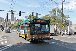
The Seattle trolleybus system forms part of the public transportation network in the city of Seattle, Washington, operated by King County Metro. Originally opened on April 28, 1940, the network consists of 15 routes, with 174 trolleybuses operating on 68 miles (109 km) of two-way parallel overhead lines. As of the second quarter of 2024, the system carries riders on an average of 39,900 trips per weekday, comprising about 18 percent of King County Metro's total daily ridership.

Broadway is a major north–south thoroughfare in Seattle, Washington. The 1.6-mile-long (2.6 km) arterial runs north from Yesler Way at Yesler Terrace through the First Hill and Capitol Hill neighborhoods to East Roy Street. Broadway East continues north to East Highland Drive. North of there the street is made up of shorter segments: one from just south of East Blaine Street to just north of East Miller Street, another from East Roanoke Street to East Shelby Street, and the last from East Allison Street to Fuhrman Avenue East.

The C Line is one of seven RapidRide lines operated by King County Metro in King County, Washington. The C Line began service on September 29, 2012, running between downtown Seattle, West Seattle, Fauntleroy and the Westwood Village Shopping Center in the Westwood neighborhood. The line runs mainly via Westlake Avenue, 3rd Avenue, Washington State Route 99, the West Seattle Bridge, California Avenue and Fauntleroy Way.

The Seattle Municipal Street Railway was a city-owned streetcar network that served the city of Seattle, Washington and its suburban neighborhoods from 1919 to 1941. It was a successor to the horse-drawn Seattle Street Railway established in 1884, and immediate successor to the Puget Sound Traction, Power and Light Company's Seattle division.
The RapidRide G Line is a RapidRide bus service in Seattle, Washington, operated by King County Metro on Madison Street between Downtown Seattle and Madison Valley. It uses a mix of side and center platforms at its 21 stations. The line opened for service on September 14, 2024, and cost $133.4 million to construct.

Westlake Avenue is a major street in Seattle, Washington, connecting Downtown Seattle to the neighborhoods of South Lake Union, Westlake and northeastern Queen Anne. The street runs north–south along the west side of Lake Union for 2.5 miles (4.0 km) from McGraw Square to the Fremont Bridge.
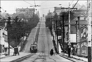
The Queen Anne Counterbalance was a funicular streetcar line operated by the Seattle Electric Company, serving the steep slope along its namesake street on Queen Anne Hill in Seattle, Washington, from 1901 to 1940. It replaced an earlier cable car line built by the Front Street Cable Railway in 1891.


