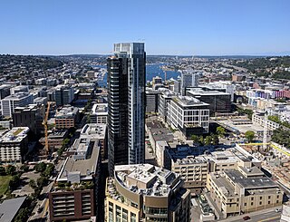
Belltown is the most densely populated neighborhood in Seattle, Washington, United States, located on the city's downtown waterfront on land that was artificially flattened as part of a regrading project. Formerly a low-rent, semi-industrial arts district, in recent decades it has transformed into a neighborhood of trendy restaurants, boutiques, nightclubs, and residential towers as well as warehouses and art galleries. The area is named after William Nathaniel Bell, on whose land claim the neighborhood was built.

Capitol Hill is a densely populated residential district and a neighborhood in Seattle, Washington, United States. It is immediately east of Downtown Seattle and north of First Hill. The neighborhood is one of the city's most popular nightlife and entertainment districts and is home to a historic gay village and vibrant counterculture community.

The street layout of Seattle is based on a series of disjointed rectangular street grids. Most of Seattle and King County use a single street grid, oriented on true north. Near the center of the city, various land claims were platted in the 19th century with differently oriented grids, which still survive today. Distinctly oriented grids also exist in some cities annexed by Seattle in the early 20th century, such as Ballard and Georgetown. A small number of streets and roads are exceptions to the grid pattern.

Downtown is the central business district of Seattle, Washington. It is fairly compact compared with other city centers on the U.S. West Coast due to its geographical situation, being hemmed in on the north and east by hills, on the west by Elliott Bay, and on the south by reclaimed land that was once tidal flats. It is bounded on the north by Denny Way, beyond which are Lower Queen Anne, Seattle Center, and South Lake Union; on the east by Interstate 5, beyond which is Capitol Hill to the northeast and Central District to the east; on the south by S Dearborn Street, beyond which is Sodo; and on the west by Elliott Bay, a part of Puget Sound.

The Denny Triangle is a neighborhood in Seattle, Washington, United States, that stretches north of Downtown Seattle to the grounds of the Seattle Center. Its generally flat terrain was originally a steep hill, taken down as part of a mammoth construction project in the first decades of the 20th century known as the Denny Regrade, which is another name for the neighborhood on the regraded area. The name Denny Triangle, referring to the northeastern portion of this regrading project, is a term that has gained currency as this neighborhood has seen increasing development in the first decades of the 21st century.

The Downtown Seattle Transit Tunnel (DSTT), also referred to as the Metro Bus Tunnel, is a 1.3-mile-long (2.1 km) pair of public transit tunnels in Seattle, Washington, United States. The double-track tunnel and its four stations serve Link light rail trains on the 1 Line as it travels through Downtown Seattle. It runs west under Pine Street from 9th Avenue to 3rd Avenue, and south under 3rd Avenue to South Jackson Street. 1 Line trains continue north from the tunnel to Lynnwood City Center and south through the Rainier Valley past Seattle–Tacoma International Airport to Angle Lake station as part of Sound Transit's light rail network.

South Lake Union is a neighborhood in central Seattle, Washington, so named because it is at the southern tip of Lake Union.

Westlake Center is a four-story shopping center and 25-story office tower in downtown Seattle, Washington, United States. The southern terminus of the Seattle Center Monorail, it is located across Pine Street from Westlake Park, between 4th and 5th Avenues. It is named for Westlake Avenue, which now terminates north of the mall but once ran two blocks farther south to Pike Street. Westlake Park is considered Seattle's "town square" and celebrities and political figures often make appearances or give speeches from the building's balcony. The anchor stores are Saks Off 5th and Nordstrom Rack.

Westlake Park is a 0.1-acre (400 m2) public plaza in Downtown Seattle, Washington, United States. It was designed by Robert Mitchell Hanna.

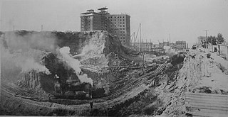
The topography of central Seattle was radically altered by a series of regrades in the city's first century of urban settlement, in what might have been the largest such alteration of urban terrain at the time.

Alaskan Way, originally Railroad Avenue, is a street in Seattle, Washington, that runs along the Elliott Bay waterfront from just north of S. Holgate Street in the Industrial District—south of which it becomes East Marginal Way S.— to Broad Street in Belltown, north of which is Myrtle Edwards Park and the Olympic Sculpture Park. The right-of-way continues northwest through the park, just west of the BNSF Railway mainline, and the roadway picks up again for a few blocks at Smith Cove. It follows a route known in the late 19th century as the "Ram's Horn" because of its shape. The street gave its name to the Alaskan Way Viaduct, which until 2019 carried Washington State Route 99 through downtown Seattle. The northern section of Alaskan Way is also signed as its honorary name, Dzidzilalich.

Westlake station is a light rail station that is part of the Downtown Seattle Transit Tunnel in Seattle, Washington, United States. The station is located under Pine Street between 3rd and 6th avenues in Downtown Seattle, near Westlake Center and Westlake Park. It is served by the 1 Line, part of Sound Transit's Link light rail system, and also connected above ground by buses at several stops, the South Lake Union Streetcar, and the Seattle Center Monorail.

Capitol Hill station is a light rail station in the Capitol Hill neighborhood of Seattle, Washington, United States. The station is served by Sound Transit's Link light rail system and is located near the intersection of Broadway and East John Street. It is situated between the Westlake and University of Washington stations on the 1 Line. The station consists of an island platform approximately 65 feet (20 m) under street level, connected to three surface entrances via two mezzanines. It contains pieces of public art, including Mike Ross's sculpture Jet Kiss and two murals by cartoonist Ellen Forney.

Broadway is a major north–south thoroughfare in Seattle, Washington. The 1.6-mile-long (2.6 km) arterial runs north from Yesler Way at Yesler Terrace through the First Hill and Capitol Hill neighborhoods to East Roy Street. Broadway East continues north to East Highland Drive. North of there the street is made up of shorter segments: one from just south of East Blaine Street to just north of East Miller Street, another from East Roanoke Street to East Shelby Street, and the last from East Allison Street to Fuhrman Avenue East.

The architecture of Seattle, Washington, the largest city in the Pacific Northwest region of the U.S., features elements that predate the arrival of the area's first settlers of European ancestry in the mid-19th century, and has reflected and influenced numerous architectural styles over time. As of the early 21st century, a major construction boom continues to redefine the city's downtown area as well as neighborhoods such as Capitol Hill, Ballard and, perhaps most dramatically, South Lake Union.

Convention Place was a bus station in Seattle, Washington, United States. It served as the northern terminus of the Downtown Seattle Transit Tunnel and was used by King County Metro and Sound Transit Express buses. Link light rail, which stops at the tunnel's other four stations, did not serve Convention Place. From the station, buses continued onto the Interstate 5 reversible express lanes or Olive Way via two exits. The station's platforms were accessed via a plaza located at the intersection of Pine Street and 9th Avenue near the Washington State Convention Center and Paramount Theatre.
Denny Way is an east–west arterial street in downtown Seattle, Washington, United States. It forms the northern end of the Belltown street grid as well as the boundaries of Belltown, Lower Queen Anne, South Lake Union, Denny Triangle, and Cascade. The street continues east through Capitol Hill to Madrona as a minor neighborhood street, ending near Madrona Park on Lake Washington.

1st Avenue is a major street in Seattle, Washington, United States. It traverses Downtown Seattle, including Pioneer Square and Belltown, as well as the adjacent neighborhoods of SoDo and Lower Queen Anne. Numerous landmarks including parks, museums, and historic buildings are located along the street, including Pike Place Market. The Great Seattle Fire of 1889 destroyed much of it and it had to be rebuilt. Parades have taken place on it before and after the fire.

Westlake Avenue is a major street in Seattle, Washington, connecting Downtown Seattle to the neighborhoods of South Lake Union, Westlake and northeastern Queen Anne. The street runs north–south along the west side of Lake Union for 2.5 miles (4.0 km) from McGraw Square to the Fremont Bridge.

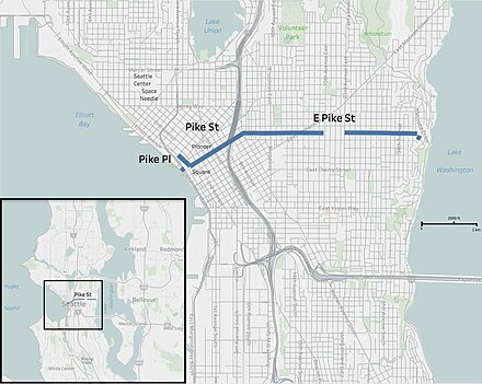
Pine Street is a major east–west street in Seattle, Washington, United States. It travels parallel to Pike Street between Downtown Seattle and the retail core to Capitol Hill, the Central District, and Madrona.


