1st Avenue is a major street in Seattle, Washington, United States. It traverses Downtown Seattle, including Pioneer Square and Belltown, as well as the adjacent neighborhoods of SoDo and Lower Queen Anne. Numerous landmarks including parks, museums, and historic buildings are located along the street, including Pike Place Market.[1] The Great Seattle Fire of 1889 destroyed much of it and it had to be rebuilt. Parades have taken place on it before and after the fire.
1st Avenue is called "Seattle's oldest thoroughfare".[2]
Seattle's original street system was a misaligned grid created by three of the original settlers. Today's 1st Avenue was Front Street north of Yesler in Arthur A. Denny's plat, and Commercial Street to its south in Doc Maynard's.[3] The grid persists in the 21st century and 1st Avenue makes two 20-degree bends where it enters and exits the Downtown Seattle core, or Denny's plat.[4]
Great Seattle Fire and Underground Seattle
View of 1st Avenue from Columbia Street after Great Seattle Fire of June 6, 1889
Parade on 1st Avenue in the early 1900s1st Avenue circa 1942
After the Great Fire, present-day Pioneer Square was rebuilt with fireproof materials including stone and brick, often with iron structural members. Historic buildings from this period on 1st Avenue that remained in the late 20th century include:[6]
Pike Place Market (opened 1907), "one of Seattle's most famous cultural and commercial institutions",[9] faces 1st Avenue on its east side, between Pike Street and Virginia Street.
Owing to the hilly terrain of Downtown Seattle, several notable public stairways run east-west intersecting 1st Avenue: the Pike Street Hillclimb, Spring Street steps and Harbor Steps connecting the Central Waterfront downhill from First; and steps outside the Jackson Federal Building and the Seattle Art Museum leading uphill from First.[12]
Crime
1st Avenue at Pike Place Market in 1972. Peepshows line the west side of the block.
After World War II, 1st Avenue was nicknamed "Flesh Avenue",[13] and from the 1950s to the 1980s, police raids at peep shows and other adult-oriented businesses in the First and Pike Street block were frequent and the corner was called a haven for "street crazies and druggies, prostitutes, players and partyers".[14]The Seattle Times said in 2006, "For decades, the Pike-Pine corridor between First and Third avenues has been known for run-down buildings, parking lots prone to drug deals and heroin addicts ... effectively a dam separating Pike Place Market and its 9 million annual visitors from the city's shopping and convention areas."[15] 1st Avenue between Bell and Blanchard, where Belltown meets Downtown, was ranked as Seattle's third most dangerous block in 2013, with 135 violent crimes reported.[16]
Gallery
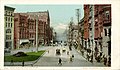
Photo postcard of 1st Avenue from the early 20th century
Woodbridge, Sally B.; Montgomery, Roger (1980). "Pioneer Square and Central Downtown and Pike Place Market". A Guide to Architecture in Washington State. University of Washington Press. pp.110–136. ISBN0-295-95779-4.
All un-suffixed roads are streets unless otherwise noted.
This page is based on this Wikipedia article Text is available under the CC BY-SA 4.0 license; additional terms may apply. Images, videos and audio are available under their respective licenses.