The BMT Brighton Line, also known as the Brighton Beach Line, is a rapid transit line in the B Division of the New York City Subway in Brooklyn, New York City, United States. Local service is provided at all times by the Q train, but is joined by the B express train on weekdays. The Q's segment on the Brighton Line begins at the line's south end, Coney Island–Stillwell Avenue, and the Q travels the entire line, over the Manhattan Bridge south tracks to the BMT Broadway Line. The B begins at Brighton Beach and runs via the bridge's north tracks to the IND Sixth Avenue Line.
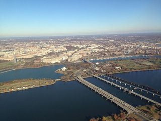
The 14th Street bridges are five bridges near each other that cross the Potomac River, connecting Arlington, Virginia and Washington, D.C. A major gateway for automotive and rail traffic, the bridge complex is named for 14th Street, which feeds automotive traffic into it on the D.C. end.
The Alaskan Way Viaduct is a defunct elevated freeway in Seattle, Washington, United States, that carried a section of State Route 99. The double-decked freeway ran north–south along the city's waterfront for 2.2 miles (3.5 km), east of Alaskan Way and Elliott Bay, and traveled between the West Seattle Freeway in SoDo and the Battery Street Tunnel in Belltown.

The Interstate Bridge is a pair of nearly identical steel vertical-lift, "Parker type" through-truss bridges that carry Interstate 5 traffic over the Columbia River between Vancouver, Washington and Portland, Oregon in the United States.
Interstate 287 (I-287) is an auxiliary Interstate Highway in the US states of New Jersey and New York. It is a partial beltway around New York City, serving the northern half of New Jersey and the counties of Rockland and Westchester in New York. I-287, which is signed north–south in New Jersey and east–west in New York, follows a roughly horseshoe-shaped route from the New Jersey Turnpike (I-95) in Edison Township, New Jersey, clockwise to the New England Thruway (I-95) in Rye, New York, for 98.72 miles (158.87 km). Through New Jersey, I-287 runs west from its southern terminus in Edison through suburban areas. In Bridgewater Township, the freeway takes a more northeasterly course, paralleled by U.S. Route 202 (US 202). The northernmost part of I-287 in New Jersey passes through mountainous surroundings. After crossing into New York at Suffern, I-287 turns east on the New York State Thruway (I-87) and runs though Rockland County. After crossing the Hudson River on the Tappan Zee Bridge, I-287 splits from I-87 near Tarrytown and continues east through Westchester County on the Cross-Westchester Expressway until it reaches the New England Thruway.

The St. Elmo W. Acosta Bridge spans the St. Johns River in Jacksonville, Florida on a fixed span. It was named for City Councilman St. Elmo W. Acosta, who convinced voters to approve a $950,000 bond issue for the original bridge. It carries SR 13 with the two-track Jacksonville Skyway in the median. Prior to its replacement in 1991, the bridge, originally called St. Johns River Bridge, opened in 1921 and carried three lanes on a lift bridge of similar design to the Main Street Bridge but was known as the Yellow Monster, largely for its tendency to stick in the upward position. Tolls were charged until 1940, earning more than $4 million for the City of Jacksonville. At some time in 1991, the original bridge was closed to allow construction of the new one to proceed.
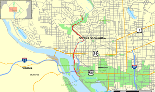
The Rock Creek and Potomac Parkway, often known simply as the Rock Creek Parkway, is a parkway maintained by the National Park Service as part of Rock Creek Park in Washington, D.C. It runs next to the Potomac River and Rock Creek in a generally north–south direction, carrying four lanes of traffic from the Lincoln Memorial and Arlington Memorial Bridge north to a junction with Beach Drive near Connecticut Avenue at Calvert Street, N.W., just south of the National Zoological Park.
Interstate 495 (I-495) is a 11.47-mile (18.46 km) long Interstate highway in the U.S. state of Delaware. The highway serves as a six-lane bypass of I-95 around the city of Wilmington. I-495 begins at an interchange with I-95 and I-295 near Newport to the southwest of Wilmington. From here, the road heads east to the Port of Wilmington, where it turns northeast and crosses the Christina River as it heads to the east of downtown Wilmington. Upon reaching Edgemoor, I-495 runs between the Delaware River to the east and U.S. Route 13 to the west, continuing to Claymont. In Claymont, I-495 turns north and merges into northbound I-95 at an interchange with Delaware Route 92 just south of the Pennsylvania state line.

Interstate 275 (I-275), located in Florida, is a 60-mile-long (97 km) highway serving the Tampa Bay Area. Its southern terminus is at Interstate 75 near Palmetto, where I-275 heads west towards the Sunshine Skyway Bridge crossing over Tampa Bay. From that point, I-275 passes through St. Petersburg before crossing Tampa Bay again on the Howard Frankland Bridge, then continues through the city of Tampa, where it connects to an interchange with Interstate 4 in Downtown Tampa. After the interchange, I-275 passes north through the Tampa suburbs to its northern terminus at Interstate 75 in Wesley Chapel.

The MAX Yellow Line is a light rail service of TriMet's MAX Light Rail system in Portland, Oregon, United States. It connects North Portland, Portland City Center, and Portland State University, running north–south from the Portland Expo Center to the Rose Quarter along the 5.8-mile (9.3 km) Interstate MAX extension and through downtown Portland on Southwest 6th Avenue. The line serves 17 stops between the Expo Center and PSU South/Southwest 6th and College stations. Seven stops occupy the median of North Interstate Avenue, giving the line its name; seven lie along the northbound segment of the Portland Transit Mall. It runs for approximately 21 hours daily from Monday to Sunday with a minimum headway of fifteen minutes during most of the day. The Yellow Line is the fourth-busiest service in the MAX system, carrying an average of 13,170 daily weekday riders in September 2018.
The high-level West Seattle Bridge, officially the Jeanette Williams Memorial Bridge, is a cantilevered segmental bridge that serves as the primary connection between West Seattle and the rest of the city. It was built between 1981 and 1984 after the previous bascule bridge was deemed inoperable as a result of being struck by the freighter Antonio Chavez in 1978.

South Park is a neighborhood in the city of Seattle, in the U.S. state of Washington. It is located just south of Georgetown across the Duwamish River, and just north of the city of Tukwila. Its main thoroughfares are West Marginal Way S., S. Cloverdale Street and 14th Ave. S (north-and-south). South Park connects to Georgetown by two bridges at 1st Ave S. at the northmost end of the neighborhood, and the South Park Bridge at the north end of 14th Ave. South. The South Park Bridge was closed on June 30, 2010 and reconstructed due to safety concerns. The newly constructed bridge reopened to traffic on June 30, 2014.

The Birmingham Bridge is a bowstring arch bridge in Pittsburgh, Pennsylvania, which crosses over the Monongahela River. The bridge connects East Carson Street on the South Side with Fifth and Forbes Avenues going to Uptown, Oakland, and the Hill District. It is named in honor of the English city of Birmingham and also for the neighborhood it connects to, which was once called Birmingham, now a part of the South Side. Many locals also may refer to it with its unofficial name, the 22nd Street bridge.
Interstate 95 (I-95) is an Interstate highway running from Miami, Florida, north to Houlton, Maine. In the U.S. state of Pennsylvania, it runs 44.25 miles (71.21 km) from the Delaware state line near Marcus Hook to the Delaware River–Turnpike Toll Bridge at the New Jersey state line. From the Delaware state line to exit 40, the route is known by many as the Delaware Expressway, but is officially named the Vietnam Veterans Memorial Highway. North(east) of exit 40, I-95 runs along the easternmost portion of the Pennsylvania Turnpike. I-95 parallels its namesake Delaware River for its entire route through the city of Philadelphia and its suburbs. It is a major route through the city and the metropolitan Delaware Valley, providing access to locally important landmarks such as Philadelphia International Airport, the South Philadelphia Sports Complex, Talen Energy Stadium, Penn's Landing, and Philadelphia Mills. Of the 15 states that Interstate 95 runs through, Pennsylvania is the only one that does not border the Atlantic Ocean.

The Pearl Harbor Memorial Bridge, more commonly referred to as the Q Bridge by locals, is an extradosed bridge that carries Interstate 95 over the mouth of the Quinnipiac River in New Haven, in the U.S. state of Connecticut. The original 1,300 m (0.8 mi) span – which opened on January 2, 1958 – was a girder and floorbeam design where steel beams support the concrete bridge deck. The bridge carried three lanes of traffic in each direction with no inside or outside shoulders. The bridge was officially dedicated as the Pearl Harbor Memorial Bridge in 1995 to commemorate the attack on Pearl Harbor.
Moses Wheeler Bridge carries Interstate 95 over the Housatonic River between Stratford and the Devon section of Milford. The current bridge is a 14-span continuous girder and floorbeam structure that carries three lanes of traffic in each direction, with full inside and outside shoulders. The current bridge, completed in 2016, replaces a pre-existing structure that was completed as part of the original Connecticut Turnpike in 1958. The original bridge was a 34-span plate girder structure with a concrete deck with three 12-foot travel lanes in each direction and no shoulders. The central span of the original bridge over the river's navigation channel included a pin and hanger assembly, which are no longer used in bridge construction. Construction on the Moses Wheeler Bridge began in 1955 and opened on January 2, 1958.
The Yadkin River Bridges are bridges crossing the Yadkin River between Rowan and Davidson Counties near Spencer, North Carolina in the United States. The northbound span of the Yadkin River Veterans Memorial Bridge, the first of two carrying Interstate 85 / U.S. Highway 52, opened May 5, 2012, and on August 2, 2012, southbound traffic moved to that span as well. A southbound span of the same bridge was completed in October 2012 and opened to traffic in March 2013. Each span carries four lanes of traffic.

The Twin Bridges are a pair of steel-plate girder bridges that span the Schuylkill River in Fairmount Park in Philadelphia, Pennsylvania. They carry northbound and southbound traffic on US 1 just north of its intersection with Interstate 76.