Salmon Bay Bridge

Last updated
Salmon Bay Bridge
SalmonBayBridge.JPG
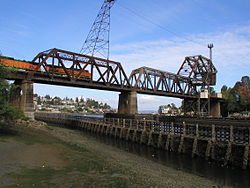
Salmon Bay Bridge seen from the southeast
Coordinates 47°40′00″N122°24′08″W / 47.66680°N 122.40213°W / 47.66680; -122.40213
CarriesBNSF Scenic Subdivision
CrossesSalmon Bay
Other name(s)Bridge No. 4 (GN), Bridge 6.3 (BNSF)
Characteristics
Design Bascule
MaterialSteel
Total length1,140 ft (350 m) [1]
Width26 ft (7.9 m) [1]
Clearance above 43 ft (13 m) [2]
Rail characteristics
No. of tracks 2 [1]
History
Opened1914
Statistics
Daily traffic 30-40 trains per day [3]
Location
Salmon Bay Bridge

The Salmon Bay Bridge, also known as Bridge 6.3 on the BNSF railroad, [4] formerly Bridge No. 4 on the Great Northern Railroad, [5] is a Strauss Heel-trunnion single-leaf bascule bridge spanning across Salmon Bay and connecting Magnolia/Interbay to Ballard in Seattle, Washington. The bridge is located just west of Commodore Park. It carries the main line of the BNSF Railway, the Scenic Subdivision, on its way north to Everett and south to King Street Station and Seattle's Industrial District.

The Salmon Bay Bridge, which is located west of the Hiram M. Chittenden Locks, is the last bridge to span the Lake Washington Ship Canal before it becomes Puget Sound. Built in 1914 by the Great Northern Railway, it has an opening span of 61 meters (200 feet) and has two tracks. Additionally, vessel clearance when lowered is 13.1 meters (43 feet) at mean high tide, [2] and up to 15.3 meters (50 feet) at low tide. [5]

BNSF Railway initially planned to replace the Salmon Bay Bridge with a new vertical-lift bridge, but chose to repair failing components of the existing bridge following consultation with the local community. [6] [3]

Related Research Articles

<span class="mw-page-title-main">Lake Washington Ship Canal</span> Waterway in Seattle, Washington, United States

The Lake Washington Ship Canal, which runs through the city of Seattle, connects the fresh water body of Lake Washington with the salt water inland sea of Puget Sound. The Hiram M. Chittenden Locks accommodate the approximately 20-foot (6.1 m) difference in water level between Lake Washington and the sound. The canal runs east–west and connects Union Bay, the Montlake Cut, Portage Bay, Lake Union, the Fremont Cut, Salmon Bay, and Shilshole Bay, which is part of the sound.

<span class="mw-page-title-main">BNSF Railway</span> American freight railroad

BNSF Railway is the largest freight railroad in the United States. One of six North American Class I railroads, BNSF has 36,000 employees, 33,400 miles (53,800 km) of track in 28 states, and over 8,000 locomotives. It has three transcontinental routes that provide rail connections between the western and eastern United States. BNSF trains traveled over 169 million miles in 2010, more than any other North American railroad.

<span class="mw-page-title-main">Ballard, Seattle</span> Seattle Neighborhood in Washington, United States

Ballard is a neighborhood in the northwestern area of Seattle, Washington, United States. Formerly an independent city, the City of Seattle's official boundaries define it as bounded to the north by Crown Hill, to the east by Greenwood, Phinney Ridge and Fremont, to the south by the Lake Washington Ship Canal, and to the west by Puget Sound's Shilshole Bay. Other neighborhood or district boundaries existed in the past; these are recognized by various Seattle City Departments, commercial or social organizations, and other Federal, State, and local government agencies.

<span class="mw-page-title-main">Salmon Bay</span>

Salmon Bay is a portion of the Lake Washington Ship Canal, which passes through the city of Seattle, linking Lake Washington to Puget Sound, lying west of the Fremont Cut. It is the westernmost section of the canal and empties into Puget Sound's Shilshole Bay. Because of the Hiram M. Chittenden Locks, the smaller, western half of the bay is salt water, and the eastern half is fresh water. Before the construction of the Ship Canal, Salmon Bay was entirely salt water.

<span class="mw-page-title-main">Interbay, Seattle</span> Seattle Neighborhood

Interbay is a neighborhood in Seattle, Washington consisting of the valley between Queen Anne Hill on the east and Magnolia on the west, plus filled-in areas of Smith Cove and Salmon Bay. The neighborhood is bounded on the north by Salmon Bay, part of the Lake Washington Ship Canal, across which is Ballard; on the south by what remains of Smith Cove, an inlet of Elliott Bay; on the east by 15th Avenue W. and Elliott Avenue W.; and on the west by the BNSF Railway. The Ballard Bridge crosses the ship canal from Interbay to Ballard.

<span class="mw-page-title-main">Ballard Bridge</span> Drawbridge in Seattle, Washington, United States

The Ballard Bridge, also known as the 15th Avenue Bridge, is a double-leaf bascule bridge in Seattle, Washington. It carries 15th Avenue NW over Seattle's Salmon Bay between Ballard to the north and Interbay to the south. The Ballard Bridge follows the Fremont Bridge in the east in the succession of bridges spanning the Lake Washington Ship Canal, which connects Lake Washington in the east to Puget Sound in the west.

<span class="mw-page-title-main">Montlake Bridge</span> Drawbridge in Seattle, Washington, United States

The Montlake Bridge is a double-leaf bascule bridge that carries State Route 513 over Seattle's Montlake Cut—part of the Lake Washington Ship Canal—connecting Montlake and the University District.

<span class="mw-page-title-main">Ballard Terminal Railroad</span>

The Ballard Terminal Railroad Company LLC operates two Class III short line terminal railroads in western Washington, United States. Founded in 1997 to operate a three-mile spur through Seattle's Ballard neighborhood, the Ballard Terminal Railroad has expanded to operate two additional lines in the Puget Sound area, including Eastside Freight Railroad from Snohomish to Woodinville, Washington, and Meeker Southern Railroad, a 5 mi (8.0 km) segment from East Puyallup ("Meeker") to McMillin, Washington. Eastside Freight Railroad has ceased operation as of mid 2020.

<span class="mw-page-title-main">BNSF Railway Bridge 5.1</span> Railroad bridge in Portland, Oregon

The BNSF Railway Bridge 5.1, also known as the St. Johns Railroad Bridge or the Willamette River Railroad Bridge, is a through truss railway bridge with a vertical lift that spans the Willamette River in Portland, Oregon, United States. Built by the Spokane, Portland and Seattle Railway (SP&S) and completed in 1908, it was originally a swing-span bridge, and its swing-span section was the longest in the world at the time. However, 81 years later the main span was converted from a swing-type to a vertical-lift type, in order to widen the navigation channel. The lift span is one of the highest and longest in the world. The bridge consists of five sections, with the two sections closest to the bank on each side fixed.

<span class="mw-page-title-main">Magnolia, Seattle</span> Neighborhood in Seattle, Washington, United States

Magnolia is the second largest neighborhood of Seattle, Washington by area. It occupies a hilly peninsula northwest of downtown. Magnolia has been a part of the city since 1891. A good portion of the peninsula is taken up by Discovery Park, formerly the U.S. Army's Fort Lawton.

<span class="mw-page-title-main">CRRNJ Newark Bay Bridge</span> Railroad bridge connecting Elizabethport and Bayonne

The Newark Bay Bridge of the Central Railroad of New Jersey (CNJ) was a railroad bridge in New Jersey that connected Elizabethport and Bayonne at the southern end of Newark Bay. Its third and final incarnation was a four-track vertical-lift design that opened in 1926, replacing a bascule bridge from 1904 which superseded the original swing bridge from 1887. The bridge served the main line of the CNJ, carrying daily interstate trains as well as commuter trains.

<span class="mw-page-title-main">Smith Cove (Seattle)</span>

Smith Cove is a body of water, the northern part of Seattle, Washington's Elliott Bay, immediately south of the area that has been known since 1894 as Interbay. More precisely, it is the part of the bay that lies north of a line running southeasterly from the west end of Elliott Bay Marina in the northwest to the far northwest tip of Myrtle Edwards Park in the southeast.

<span class="mw-page-title-main">Burlington Northern Railroad Bridge 9.6</span> Railroad bridge crossing the Columbia River between Portland, Oregon and Vancouver, Washington

Burlington Northern Railroad Bridge 9.6 or BNSF Railway Bridge 9.6, also known as the Columbia River Railroad Bridge, is through truss railway bridge across the Columbia River, between Portland, Oregon, and Vancouver, Washington, owned and operated by BNSF Railway. Built by the Spokane, Portland and Seattle Railway (SP&S) and completed in 1908, it was the first bridge of any kind to be built across the lower Columbia River, preceding the first road bridge, the nearby Interstate Bridge, by a little more than eight years.

<span class="mw-page-title-main">Kinzie Street railroad bridge</span> Bridge in Chicago

The Chicago and North Western Railway's Kinzie Street railroad bridge is a single leaf bascule bridge across the north branch of the Chicago River in downtown Chicago, Illinois. At the time of its opening in 1908 it was the world's longest and heaviest bascule bridge. The previous bridges on the same site included a pedestrian span that was the first bridge across the Chicago River; a second bridge that served as Chicago's first railroad bridge; and a third bridge that was one of the first all-steel spans in the United States.

<span class="mw-page-title-main">Thames River Bridge (Amtrak)</span> Bridge in Connecticut and Groton, Connecticut

Amtrak's Thames River Bridge spans from New London to Groton, Connecticut, United States, crossing Connecticut's Thames River.

<span class="mw-page-title-main">Meeker Southern Railroad</span>

The Meeker Southern Railroad is a Class III shortline railroad owned by Ballard Terminal Railroad Company LLC that travels approximately 5 miles (8.0 km) between East Puyallup ("Meeker") and McMillin, Washington, United States.

The Scenic Subdivision or Scenic Sub is a railroad line running about 155 miles (249 km) from Seattle, Washington to Wenatchee, Washington. It is operated by BNSF Railway as part of their Northern Transcon. This route includes the Cascade Tunnel, as well as the 1893 site of the "last spike" near Scenic, Washington, which marked the completion for the Great Northern Railway transcontinental railway line built by James J. Hill.

<span class="mw-page-title-main">Oregon Slough Railroad Bridge</span> Railroad bridge in Portland, Oregon

The Oregon Slough Railroad Bridge, also known as the BNSF Railway Bridge 8.8, is a swing-span, through truss bridge in Portland, Oregon, United States. Currently owned and operated by BNSF Railway, it crosses an anabranch of the Columbia River known as North Portland Harbor and historically as the Oregon Slough. The bridge's northern end is on Hayden Island, which, along with Tomahawk Island, forms the north shore of the channel. Completed in 1908, the two-track bridge is one of only two swing bridges surviving in Portland, which once had several bridges of that type, both for road and rail traffic. The only other remaining swing bridge in the Portland area is another rail-only bridge on the same line, BNSF's nearby Bridge 9.6, spanning the Columbia River.

References

  1. 1 2 3 Sherrard, Jean (December 22, 2012). "Seattle now & then: Ballard's bascule bridge" . Retrieved January 1, 2024.
  2. 1 2 "Bridge-Navigation". hstrial-troychilds.homestead.com. Retrieved 2018-10-29.
  3. 1 2 Banel, Feliks (November 11, 2020). "Salmon Bay bridge operator keeps railroad tradition alive". MyNorthwest. Retrieved December 1, 2020.
  4. "BNSF Ballard Bridge 6.3 Trunnion & Bearing Replacement" . Retrieved 2023-12-15.
  5. 1 2 "Bridge 4". www.gngoat.org. Retrieved 2018-10-29.
  6. Lester, David C. (October 16, 2020). "BNSF chooses to repair, not replace, Salmon Bay Bridge". Railway Track & Structures . Retrieved December 1, 2020.