
A swing bridge is a movable bridge that can be rotated horizontally around a vertical axis. It has as its primary structural support a vertical locating pin and support ring, usually at or near to its center of gravity, about which the swing span can then pivot horizontally as shown in the animated illustration to the right.
State Route 520 (SR 520) is a state highway and freeway in the Seattle metropolitan area, part of the U.S. state of Washington. It runs 13 miles (21 km) from Seattle in the west to Redmond in the east. The freeway connects Seattle to the Eastside region of King County via the Evergreen Point Floating Bridge on Lake Washington. SR 520 intersects several state highways, including Interstate 5 (I-5) in Seattle, I-405 in Bellevue, and SR 202 in Redmond.

State Route 99 (SR 99), also known as the Pacific Highway, is a state highway in the Seattle metropolitan area, part of the U.S. state of Washington. It runs 49 miles (79 km) from Fife to Everett, passing through the cities of Federal Way, SeaTac, Seattle, Shoreline, and Lynnwood. The route primarily follows arterial streets, including Aurora Avenue, and has several freeway segments, including the tolled SR 99 Tunnel in Downtown Seattle. SR 99 was officially named the William P. Stewart Memorial Highway by the state legislature in 2016, after a campaign to replace an unofficial moniker honoring Confederate president Jefferson Davis.

The University Bridge is a double-leaf bascule bridge in Seattle, Washington that carries Eastlake Avenue traffic over Portage Bay between Eastlake to the south and the University District to the north. It opened on July 1, 1919, and was extensively rebuilt from 1932 to 1933. It is included in the National Register of Historic Places.
The Alaskan Way Viaduct was an elevated freeway in Seattle, Washington, United States, that carried a section of State Route 99. The double-decked freeway ran north–south along the city's waterfront for 2.2 miles (3.5 km), east of Alaskan Way and Elliott Bay, and traveled between the West Seattle Freeway in SoDo and the Battery Street Tunnel in Belltown.

The Hood Canal Bridge is a floating bridge in the northwest United States, located in western Washington. It carries State Route 104 across Hood Canal in Puget Sound and connects the Olympic and Kitsap Peninsulas. At 7,869 feet in length, it is the longest floating bridge in the world located in a saltwater tidal basin, and the third longest floating bridge overall. It opened in 1961 and was the second concrete floating bridge constructed in Washington. Since that time, it has become a vital link for local residents, freight haulers, commuters, and recreational travelers. The convenience it provides has had a major impact on economic development, especially in eastern Jefferson County.

The BNSF Railway Bridge 5.1, also known as the St. Johns Railroad Bridge or the Willamette River Railroad Bridge, is a through truss railway bridge with a vertical lift that spans the Willamette River in Portland, Oregon, United States. Built by the Spokane, Portland and Seattle Railway (SP&S) and completed in 1908, it was originally a swing-span bridge, and its swing-span section was the longest in the world at the time. However, 81 years later the main span was converted from a swing-type to a vertical-lift type, in order to widen the navigation channel. The lift span is one of the highest and longest in the world. The bridge consists of five sections, with the two sections closest to the bank on each side fixed.

The Seven Mile Bridge is a bridge in the Florida Keys, in Monroe County, Florida, United States. It connects Knight's Key in the Middle Keys to Little Duck Key in the Lower Keys. Among the longest bridges in existence when it was built, it is part of the Overseas Highway in the Keys, which is part of the 2,369-mile (3,813 km) U.S. Route 1.

The Broadway Bridge is a vertical-lift bridge across the Harlem River Ship Canal in the borough of Manhattan in New York City. It connects the neighborhoods of Inwood on Manhattan Island and Marble Hill on the mainland. The bridge consists of two decks. The lower deck carries Broadway, which is designated as U.S. Route 9 at this location. The upper deck carries the New York City Subway's IRT Broadway–Seventh Avenue Line, serving the 1 train.

The 1 Line, formerly Central Link, is a light rail line in Seattle, Washington, United States, and part of Sound Transit's Link light rail system. It serves 19 stations in the cities of Seattle, SeaTac, and Tukwila, traveling nearly 25 miles (40 km) between Northgate and Angle Lake stations. The line connects the University District, Downtown Seattle, the Rainier Valley, and Seattle–Tacoma International Airport. The 1 Line carried over 26 million total passengers in 2023, with an average of nearly 80,000 daily passengers on weekdays. It runs for 20 hours per day on weekdays and Saturdays, with headways as low as six minutes during peak hours, and reduced 18-hour service on Sundays and holidays.

The West Seattle Bridge, officially the Jeanette Williams Memorial Bridge, is a cantilevered segmental bridge that serves as the primary connection between West Seattle and important highways such as State Route 99, the Spokane Street Viaduct, and Interstate 5. It was built between 1981 and 1984 after the previous bascule bridge was deemed inoperable as a result of being struck by the freighter Antonio Chavez in 1978.

The New Richmond Swing Bridge, also known as the Fifty-Seventh Street Bridge, is a one lane swing bridge in Michigan. Located in Allegan County's Manlius Township, it connected 57th Street with Old Allegan Road over the Kalamazoo River until its closure to vehicular traffic. The name New Richmond comes from a former mining town in the area of the same name. The bridge is one of the oldest - if not the oldest - swing bridges extant in the United States, and is one of the oldest metal truss bridges in the state of Michigan and the state's longest pony truss bridge.

The South Lake Union Streetcar, officially the South Lake Union Line, is a streetcar route in Seattle, Washington, United States, forming part of the Seattle Streetcar system. It travels 1.3 miles (2.1 km) and connects Downtown Seattle to the South Lake Union neighborhood on Westlake Avenue, Terry Avenue, and Valley Street. The South Lake Union Streetcar was the first modern line to operate in Seattle, beginning service on December 12, 2007, two years after a separate heritage streetcar ceased operations.

The Oregon Trunk Rail Bridge or Celilo Bridge is a single-track railroad bridge opened in 1912 over the Columbia River in the Pacific Northwest of the United States. It consists of eight steel truss spans and several deck girder spans, and since 1957 it has included a vertical-lift section. The bridge was designed by engineer Ralph Modjeski and erected by the Missouri Valley Bridge & Iron Co., of Leavenworth, Kansas.

Interstate 90 (I-90), designated as the American Veterans Memorial Highway, is a transcontinental Interstate Highway that runs from Seattle, Washington, to Boston, Massachusetts. It crosses Washington state from west to east, traveling 298 miles (480 km) from Seattle across the Cascade Mountains and into Eastern Washington, reaching the Idaho state line east of Spokane. I-90 intersects several of the state's other major highways, including I-5 in Seattle, I-82 and U.S. Route 97 (US 97) near Ellensburg, and US 395 and US 2 in Spokane.

The Spokane Street Viaduct is a freeway connecting the West Seattle Bridge to Interstate 5. It runs above South Spokane Street in the SoDo neighborhood of Seattle and is generally four to six lanes wide.
The West Jefferson Avenue–Rouge River Bridge is a historic double-leaf bascule bridge in Wayne County, Michigan, at the border of the cities of Detroit and River Rouge. The bridge carries Jefferson Avenue, a major thoroughfare in Southwest Detroit, over the River Rouge, an important inland route for lake freighters. The bridge was built in 1922, and was listed on the National Register of Historic Places in 2000.

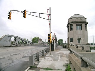
At 2:38 a.m. on June 11, 1978, the freighter Antonio Chavez rammed the West Spokane Street Bridge, thereby closing it to automobile traffic for the next six years. The pilot and master were both found negligent in causing the collision. The collision led to the opening of the current West Seattle Bridge in 1984. The incident occurred in west fork of the Duwamish Waterway, as the Chavez hit the West Spokane Street Bridge which had been raised to allow the ship to pass through. This blocked eastbound traffic to West Seattle, until the westbound span was temporarily adapted to handle two-way traffic.

The West Spokane Street Bridge was a pair of bascule bridges that crossed the west fork of the Duwamish River in Seattle, Washington, United States. The bridges connected the SoDo and West Seattle neighborhoods over the river. The original bridge opened to traffic in 1924; a second bridge carrying eastbound traffic was opened in 1930, with the 1924 bridge reconfigured to carry westbound traffic.


