West Spokane Street Bridge

Last updated

West Spokane Street Bridge
Seattle - Spokane Street Bridges, 1931 (48232722292).jpg
The bridges in 1931, as seen from Pigeon Point in Delridge, West Seattle
Coordinates 47°34′17″N122°21′12″W / 47.57139°N 122.35333°W / 47.57139; -122.35333 Coordinates: 47°34′17″N122°21′12″W / 47.57139°N 122.35333°W / 47.57139; -122.35333
CarriesSpokane Street
Crosses Duwamish River
Locale Seattle, Washington, U.S.
Other name(s)Spokane Street Bridge
Maintained by Seattle Engineering Department
Characteristics
Design Bascule bridge
No. of spans2
History
Opened
  • December 1924 (westbound)
  • September 20, 1930 (eastbound)
Closed
  • June 11, 1978 (westbound)
  • May 23, 1989 (eastbound)
Location
West Spokane Street Bridge

The West Spokane Street Bridge was a pair of bascule bridges that crossed the west fork of the Duwamish River in Seattle, Washington, United States. The bridges connected the SoDo and West Seattle neighborhoods over the river. The original bridge opened to traffic in 1924; a second bridge carrying eastbound traffic was opened in 1930, with the 1924 bridge reconfigured to carry westbound traffic.

Contents

Both bridges carried traffic until 1978, when a freighter rammed into the 1924 bridge; the 1930 bridge was subsequently reconfigured to handle two-way traffic as a result. The 1930 bridge was replaced in official capacity by the higher-level Jeanette Williams Memorial Bridge (a.k.a. the West Seattle Bridge) in 1984. The 1930 span of the bridge was closed in 1989 and subsequently demolished to make way for a lower swing bridge connecting West Seattle to Harbor Island (now known as the Spokane Street Bridge, which opened in 1991).

Background and early years

The first permanent bridge under construction in June 1924; the 1918 temporary bridge is on the right Old and new West Spokane Street Bridges, Seattle, June 28, 1924 (MOHAI 9078).jpg
The first permanent bridge under construction in June 1924; the 1918 temporary bridge is on the right

The West Spokane Street Bridge crossed the Duwamish River from Harbor Island to West Seattle. [1] "Spokane Street" has long been used as designation for the streets running along the latitude of the current West Seattle Bridge. [2] Before any permanent bridge was built along the line of Spokane Street, there had been three temporary bridges, built c.1900, c.1910, and c.1918. The first one was basically a swinging gate in what had been primarily built as a water main; the second was a swing bridge that also carried a water main, and the third was a swing bridge after the water main had been rerouted elsewhere. [3]

A more permanent bascule bridge was constructed in 1924, which lasted for several decades; a second, parallel bridge was constructed south of the first in 1930. [4] In 1945, one of Seattle's oldest freeways (the Spokane Street Viaduct) connected the bridge to Beacon Hill. Prior to the construction of Interstate 5, the viaduct was separated from the bridge by the main north-south corridor, U.S. Route 99.

Replacement project

Traffic on the 1924 bridge in May 1930 Seattle - Traffic on West Spokane Street Bridge, 1930.jpg
Traffic on the 1924 bridge in May 1930

By the 1970s, the West Spokane Street Bridge was one of Seattle's worst bottlenecks, due to the large number of ships in Duwamish Waterway and the frequent bridge openings. City leaders began planning a higher bridge, without a drawbridge, in the 1960s. Planning for the bridge was hampered by difficulties in receiving funding. In large part, this is because the bridge was not a designated highway. A 1968 Forward Thrust ballot measure included $16.7 million in funding for the bridge, largely to receive votes from West Seattle residents. Other funding sources included a state program for funding urban streets and money from a maintenance fund.

After a long drawn-out process, three companies eventually bid to design the bridge for $1.5 million. However, the city engineer chose a fourth company that was financially connected to the speaker of the state house. The price from this fourth company was triple the cost of the other three. This was a result of a series of bribes involving the head of the House Transportation Committee, the city engineer and others. Despite the 68 percent support in the 1968 ballot measure, the state withdrew its urban streets money due to the scandal. In 1976 and 1977, the conspirators were placed on trial and imprisoned.

After the scandal, the project was considered dead. Norbert Tiemann, a federal highway regulator, stated that there would essentially be no chance of the project receiving federal funds for completion. Tiemann also quipped, "Short of a tug knocking it down (which could trigger federal special bridge replacement funds), there is nothing else. And you certainly wouldn't want to go that route." [5] In March 1978, several prominent West Seattle residents filed a petition to organize a secession referendum, with the hopes of finding state funding for a new bridge to serve their independent city. [6] The secession campaign was required to gather 29,000 signatures for a ballot measure, but were unable to meet the threshold before the northern or westbound drawbridge was permanently closed and all east-west traffic was funneled over the southern span. [6] [7]

1978 collision

The Antonio Chavez, the ship that struck the 1924 bridge, as seen the day after the collision Freighter Antonio Chavez, 1978.gif
The Antonio Chavez, the ship that struck the 1924 bridge, as seen the day after the collision

At 2:38 a.m. on June 11, 1978, the freighter Chavez rammed the West Spokane Street Bridge over the Duwamish West Waterway. No one was hurt in the collision, but it resulted in irreparable damage with the bridge's spans stuck open; the bridge was permanently closed as a result. A US Coast Guard inquiry found the ship's pilot, Rolf Neslund, and master, Gojko Gospodnetic, were negligent; Gospodnetic was fired and Neslund forced into retirement. [8] Neslund later disappeared in 1980. Although he was never found, his wife was convicted of his murder. [9]

Replacement bridges

The high span West Seattle Bridge project qualified for funds from the federal Office of Special Bridge Replacement as a result of the 1978 collision. However, with many other damaged bridges to replace, this program alone did not have sufficient funding. While federal lawmakers were opposed to appropriating funds to a high-level bridge, Seattle City Council member Jeanette Williams, who served on the council from 1970 to 1989, lobbied Congress for the bridge and successfully secured funds with help from Senator Warren Magnuson. [10] [11] The high span bridge was completed in 1984, though demolition of the 1924 bridge continued until January 1986. [8] [12] Meanwhile, the 1930 bridge continued to carry traffic (around 12,000 vehicles per day [13] ) until it was closed on May 23, 1989, and subsequently demolished to make way for construction of the similarly-named Spokane Street Bridge, a swing bridge that opened in 1991; Kiewit Corporation handled both projects. [8] [14] Before the West Seattle Bridge opened, many of the neighborhoods in West Seattle had low property values because of the difficulty in getting downtown.[ citation needed ]

The West Seattle Bridge was closed in March 2020 after cracks in the underside were found to be growing rapidly, necessitating a major repair amid the COVID-19 pandemic. The bridge reopened in September 2022.

Related Research Articles

<span class="mw-page-title-main">Duwamish River</span> River in Washington, United States

The Duwamish River is the name of the lower 12 miles (19 km) of Washington state's Green River. Its industrialized estuary is known as the Duwamish Waterway. In 2009, the Duwamish Longhouse and Cultural Center was opened on the west bank of the river as part of the tribe's reassertion of its historic rights in the area and its continuing struggle for federal recognition of tribal status.

<span class="mw-page-title-main">Swing bridge</span> Bridge which pivots around the mid-point

A swing bridge is a movable bridge that has as its primary structural support a vertical locating pin and support ring, usually at or near to its center of gravity, about which the swing span can then pivot horizontally as shown in the animated illustration to the right. Small swing bridges as found over canals may be pivoted only at one end, opening as would a gate, but require substantial underground structure to support the pivot.

<span class="mw-page-title-main">Washington State Route 99</span> Highway in the Seattle metropolitan area, Washington, U.S.

State Route 99 (SR 99), also known as the Pacific Highway, is a state highway in the Seattle metropolitan area, part of the U.S. state of Washington. It runs 49 miles (79 km) from Fife in the south to Everett in the north, passing through the cities of Federal Way, SeaTac, Seattle, Shoreline, and Lynnwood. The route primarily follows arterial streets, including Aurora Avenue, and has several freeway segments, including the tolled SR 99 Tunnel in Downtown Seattle. SR 99 was officially named the William P. Stewart Memorial Highway by the state legislature in 2016, after a campaign to replace an unofficial moniker honoring Confederate president Jefferson Davis.

<span class="mw-page-title-main">Fremont Bridge (Seattle)</span> Drawbridge in Seattle, Washington, United States

The Fremont Bridge is a double-leaf bascule bridge that spans the Fremont Cut in Seattle, Washington. The bridge, which connects Fremont Avenue North and 4th Avenue North, connects the neighborhoods of Fremont and Queen Anne.

<span class="mw-page-title-main">Burlington Northern Railroad Bridge 5.1</span> Railroad bridge in Portland, Oregon

The Burlington Northern Railroad Bridge 5.1 or BNSF Railway Bridge 5.1, also known as the St. Johns Railroad Bridge or the Willamette River Railroad Bridge, is a through truss railway bridge with a vertical lift that spans the Willamette River in Portland, Oregon, United States. Built by the Spokane, Portland and Seattle Railway (SP&S) and completed in 1908, it was originally a swing-span bridge, and its swing-span section was the longest in the world at the time. However, 81 years later the main span was converted from a swing-type to a vertical-lift type, in order to widen the navigation channel. The lift span is one of the highest and longest in the world. The bridge consists of five sections, with the two sections closest to the bank on each side fixed.

<span class="mw-page-title-main">Johnson Street Bridge</span> Bridges in Victoria, British Columbia, Canada

Four known bridges have spanned the narrows between the Inner Harbour and Upper Harbour of Victoria, British Columbia, connecting Johnson Street on the east shore with Esquimalt Road on the west shore. The current bridge is Canada's largest single-leaf bascule bridge.

<span class="mw-page-title-main">Moveable bridge</span>

A moveable bridge, or movable bridge, is a bridge that moves to allow passage for boats or barges. In American English, the term is synonymous with drawbridge, and the latter is the common term, but drawbridge can be limited to the narrower, historical definition used in some other forms of English, in which drawbridge refers to only a specific type of moveable bridge often found in castles.

<span class="mw-page-title-main">West Seattle Bridge</span> Bridge in Seattle, Washington

The West Seattle Bridge, officially the Jeanette Williams Memorial Bridge, is a cantilevered segmental bridge that serves as the primary connection between West Seattle and important highways such as State Route 99, the Spokane Street Viaduct, and Interstate 5. It was built between 1981 and 1984 after the previous bascule bridge was deemed inoperable as a result of being struck by the freighter Antonio Chavez in 1978.

<span class="mw-page-title-main">South Park, Seattle</span> Neighborhood of Seattle, Washington, US

South Park is a neighborhood in Seattle, Washington. It is located just south of Georgetown across the Duwamish River, and just north of the city of Tukwila. Its main thoroughfares are West Marginal Way S., S. Cloverdale Street and 14th Ave. S (north-and-south). South Park connects to Georgetown by two bridges at 1st Ave S. at the northmost end of the neighborhood, and the South Park Bridge at the north end of 14th Ave. South. The South Park Bridge was closed on June 30, 2010, and reconstructed due to safety concerns. The newly constructed bridge reopened to traffic on June 30, 2014.

<span class="mw-page-title-main">CRRNJ Newark Bay Bridge</span> Railroad bridge connecting Elizabethport and Bayonne

The Newark Bay Bridge of the Central Railroad of New Jersey (CNJ) was a railroad bridge in New Jersey that connected Elizabethport and Bayonne at the southern end of Newark Bay. Its third and final incarnation was a four-track vertical-lift design that opened in 1926, replacing a bascule bridge from 1904 which superseded the original swing bridge from 1887. The bridge served the main line of the CNJ, carrying daily interstate trains as well as commuter trains.

<span class="mw-page-title-main">First Avenue South Bridge</span> Highway drawbridge in Seattle, Washington, United States

The First Avenue South Bridge is a pair of double-leaf bascule bridges built between 1956 and 1998 that carry State Route 99 over the Duwamish River about three miles (5 km) south of downtown Seattle, Washington.

<span class="mw-page-title-main">South Park Bridge</span> Drawbridge in Seattle, Washington, United States

The South Park Bridge is a Scherzer rolling lift double-leaf bascule bridge in Seattle, Washington, United States. The bridge is operated by the King County government, It carries automobile traffic over the Duwamish River near Boeing Field, just outside the city limits of Seattle, and is named for the nearby South Park neighborhood of Seattle. It was listed on the National Register of Historic Places in 1982, as the 14th Avenue South Bridge.

<span class="mw-page-title-main">Spokane Street Bridge</span> Swing bridge in Seattle, Washington, United States

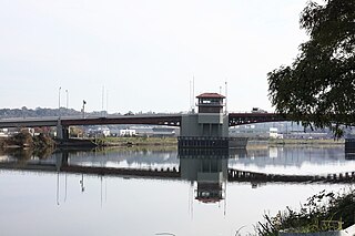
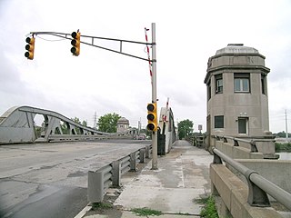
The Spokane Street Bridge, also known as the West Seattle Low-Level Bridge, is a concrete double-leaf swing bridge in Seattle, Washington. It carries Southwest Spokane Street over the Duwamish River, connecting Harbor Island to West Seattle. It has two separate end-to-end swing-span sections, each 480 feet (150 m) long. Its construction was finished in 1991, replacing an earlier bridge destroyed by a collision. It is named after Spokane Street, which itself is named after Spokane, Washington, which is named after the Spokane people.

<span class="mw-page-title-main">Park Street Bridge</span> Bridge in San Francisco Bay Area

The Park Street Bridge is a double-leaf bascule drawbridge spanning 372 feet of the Oakland Estuary in the San Francisco Bay Area. It links the cities of Oakland and Alameda. In a year, the bridge is opened approximately 1700 times and carries approximately 40,000 vehicles per work day. It was built when the Oakland Estuary was trenched, converting Alameda from a peninsula to an island.

<span class="mw-page-title-main">Spokane Street Viaduct</span>

The Spokane Street Viaduct is a freeway connecting the West Seattle Bridge to Interstate 5. It runs above South Spokane Street in the SoDo neighborhood of Seattle and is generally four to six lanes wide.

<span class="mw-page-title-main">West Jefferson Avenue–Rouge River Bridge</span> United States historic place

The West Jefferson Avenue–Rouge River Bridge is a bridge located where Jefferson Avenue crosses the Rouge River at the border of Detroit and River Rouge, Michigan. It is the only surviving pony truss bascule bridge in the state of Michigan. It was listed on the National Register of Historic Places in 2000.

<span class="mw-page-title-main">Cheboygan Bascule Bridge</span> Bridge in Cheboygan, Michigan

The Cheboygan Bascule Bridge, also known as the State Street Bridge, is a double-leaf bascule bridge in Cheboygan, Michigan, carrying U.S. Highway 23 across the Cheboygan River. Built in 1940, it was the last bascule bridge constructed in the state of Michigan prior to the end of World War II. It replaced an aging swing bridge built in 1877. The bridge is listed on the National Register of Historic Places.

<span class="mw-page-title-main">High Street Bridge</span> Bridge in San Francisco Bay Area

The High Street Bridge is a double-leaf bascule drawbridge spanning 296 feet of the Oakland Estuary in the San Francisco Bay Area, California, United States. It links the cities of Oakland and Alameda. The bridge is opened approximately 1,400 times a year. The bridge carries an average of 26,000 vehicles per year. The bridge was built when the Oakland Estuary was trenched, converting Alameda from a peninsula to an island.

<span class="mw-page-title-main">West Spokane Street Bridge collision</span>

At 2:38 a.m. on June 11, 1978, the freighter "Antonio Chavez" rammed the West Spokane Street Bridge, thereby closing it to automobile traffic for the next six years. The pilot and master were both found negligent in causing the collision. The collision led to the opening of the current West Seattle Bridge in 1984. The incident occurred in west fork of the Duwamish Waterway, as the Chavez hit the West Spokane Street Bridge which had been raised to allow the ship to pass through. This blocked eastbound traffic to West Seattle, until the westbound span was temporarily adapted to handle two-way traffic.

References

  1. "Ship Runs Into Seattle Bridge (Published 1978)". The New York Times. June 12, 1978. ISSN   0362-4331 . Retrieved December 30, 2020.
  2. images, Derivative work by Joe Mabel, using public domain (August 1, 2009), A map of Seattle in 1909, created by combining portions of the following public domain images , retrieved December 23, 2020
  3. Paul Dorpat (1984). "100 - Six Bridges to West Seattle". Seattle Now and Then. Tartu.
  4. Phelps, Myra L. (1978). Public Works in Seattle: A Narrative History [of] the Engineering Department, 1875–1975 (1st ed.). Seattle: Seattle Engineering Department. pp. 41–43. ISBN   9780960192816.
  5. Royer, Bob (June 20, 2011). "When the Ship Hit the Span". Cascadia Courier. Retrieved May 26, 2014.
  6. 1 2 Eals, Clay (May 21, 2020). "For West Seattle's bridge, if at first you don't succeed, secede!". The Seattle Times. Retrieved May 21, 2020.
  7. Suffia, David (May 10, 1978). "West Seattle secession drive progressing slowly". The Seattle Times. p. A18.
  8. 1 2 3 "Freighter Chavez rams West Seattle Bridge on June 11, 1978". HistoryLink.org.
  9. Daryl C McClary (April 9, 2007). "Ruth Neslund murders her husband, Rolf Neslund, on Lopez Island on August 8, 1980". Historylink. Retrieved May 26, 2014.
  10. "You can call it the Jeanette Williams Memorial Bridge". WestSeattleBlog. October 23, 2009.
  11. "West Seattle Bridge renamed to honor Jeanette Williams". West Seattle Herald. October 23, 2009.
  12. "Starting the year with a bang". The Seattle Times. January 1, 1986. p. A1 via NewsBank.
  13. Gough, William (February 21, 1989). "Shippers look forward to wider 'highway' lanes". The Seattle Times. p. C3 via NewsBank.
  14. "Spokane St. Bridge is closing forever". The Seattle Times. May 19, 1989. p. B3 via NewsBank.