Fremont Bridge | |
---|---|
Coordinates | 47°38′51″N122°21′00″W / 47.6475°N 122.35°W |
Carries | Fremont Avenue N |
Crosses | Fremont Cut |
Locale | Seattle, Washington |
Maintained by | Seattle Department of Transportation |
Characteristics | |
Design | bascule |
Total length | 502 feet (153 m) |
Longest span | 242 feet (74 m) |
Clearance below | 30 feet (9.1 m) |
History | |
Opened | June 15, 1917 |
Designated | December 28, 1981 [1] |
Fremont Bridge | |
Location | Spans Lake Washington Ship Canal,Seattle,Washington |
Area | less than one acre |
Built | 1917 |
Engineer | Arthur H. Dimock [2] |
MPS | Historic Bridges/Tunnels in Washington State TR |
NRHP reference No. | 82004234 [3] |
Added to NRHP | July 16,1982 |
Location | |
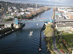
The Fremont Bridge is a double-leaf bascule bridge that spans the Fremont Cut in Seattle,Washington. The bridge,which connects Fremont Avenue North and 4th Avenue North,connects the neighborhoods of Fremont and Queen Anne.
The Fremont Bridge was opened on Friday June 15,1917,at a cost of $410,000. [4] The first traffic over the bridge was to "owl cars",the last run of the trolleys,and then after 5am the same day to all other traffic. The Lake Washington Ship Canal was dedicated on July 4,1917,which has caused confusion about the opening date,for this bridge crosses the canal. [5]
The Fremont Bridge is the first of four city bascules to cross the canal,the others being Ballard Bridge (1917),University Bridge (1919),and Montlake Bridge (1925). The bridge was added to the National Register of Historic Places in 1982,and is also a designated city landmark,ID #110347. [1]
In its early years,before the construction of the nearby Aurora Bridge in 1932,the Fremont Bridge had the most vehicle traffic of any bascule bridge in the United States. [6] In another respect,it remains among the busiest even today:due to its low vessel clearance of 30 feet (9.1 m), [7] the Fremont Bridge opens an average of 35 times a day,which makes it the most frequently opened drawbridge in the United States [8] and one of the busiest bascule bridges in the world. [9] Federal law gives marine traffic the right-of-way over vehicular traffic;however,the Fremont Bridge is closed to most water traffic during rush hours. [7]
The Fremont Bridge was originally painted a dull green. [2] In 1972,the Fremont Improvement Committee picked a new color,Fremont Orange,and residents approved the change. [2] The bridge's blue and orange color was chosen by voters at a 1985 street fair. [10]
In 2006,the Fremont Bridge underwent a $41.9 million restoration project to replace the approaches and maintenance shop,as well as renovation of the mechanical and electrical systems that operate the bascule. [11] The approaches were completed in May 2007 [12] and testing lasted through the Spring of 2008. [13] In 2014 the city began repainting the bridge. [14]
The bridge received a permanent art installation in February 2018 as part of an artist residency program coinciding with the centennial of the bridge and two of the ship canal's other bascule bridges. The Fremont Bridge was outfitted with what is to be the first of three dynamic lighting designs. The Ballard Bridge and University Bridge will also receive installations assuming funding can be secured. [15]
A bicycle counter was installed in 2012. [16] It was the first of twelve counters in the city,as of 2018. [17] Bike traffic reached 1.12 million rides in 2019,a 13% increase from the year before. [18]
The present bridge is actually the third bridge at this location. A low trestle bridge was built in 1890 or 1891. In 1911,in anticipation of the construction of the Ship Canal,it was replaced by a higher trestle bridge. While that bridge was always intended as temporary,it proved even more so than planned,because early in the afternoon of March 12,1914,the Fremont dam,which controlled the level of Lake Union,gave way. Over the course of a day,the lake level lowered by nine feet,stranding vessels and floating homes,and rupturing the central portion of the second Fremont bridge. The Stone Avenue Bridge,which included a streetcar trestle from Westlake Avenue to Stone Way,remained intact. Streetcar traffic that had used the Fremont Bridge was rerouted over that trestle until the completion of the present-day bridge. [6]
The Lake Washington Ship Canal is a canal that runs through the city of Seattle and connects the fresh water body of Lake Washington to the salt water inland sea of Puget Sound. The Hiram M. Chittenden Locks accommodate the approximately 20-foot (6.1 m) difference in water level between Lake Washington and the sound. The canal runs east–west and connects Union Bay,the Montlake Cut,Portage Bay,Lake Union,the Fremont Cut,Salmon Bay,and Shilshole Bay,which is part of the sound.
Fremont is a neighborhood in the North Central District of Seattle,Washington,United States. Originally a separate city,it was annexed to Seattle in 1891. It is named after Fremont,Nebraska,the hometown of two of its founders:Luther H. Griffith and Edward Blewett.
The Fremont Cut is a canal in Seattle,Washington,United States,that connects Lake Union to the east with Salmon Bay to the west. It is part of the Lake Washington Ship Canal linking Lake Washington to Puget Sound,and is 5,800 feet (1,800 m) long and 270 feet (82 m) wide. The center channel is 100 feet (30 m) wide and 30 feet (9.1 m) deep.
Ballard is a neighborhood in northwestern Seattle,Washington,United States. Formerly an independent city,the City of Seattle's official boundaries define it as bounded to the north by Crown Hill,to the east by Greenwood,Phinney Ridge and Fremont,to the south by the Lake Washington Ship Canal,and to the west by Puget Sound's Shilshole Bay. Other neighborhood or district boundaries existed in the past;these are recognized by various Seattle City Departments,commercial or social organizations,and other Federal,State,and local government agencies.
Salmon Bay is a portion of the Lake Washington Ship Canal,which passes through the city of Seattle,linking Lake Washington to Puget Sound,lying west of the Fremont Cut. It is the westernmost section of the canal and empties into Puget Sound's Shilshole Bay. Because of the Hiram M. Chittenden Locks,the smaller,western half of the bay is salt water,and the eastern half is fresh water.
The Hiram M. Chittenden Locks,or Ballard Locks,is a complex of locks at the west end of Salmon Bay in Seattle,Washington's Lake Washington Ship Canal,between the neighborhoods of Ballard to the north and Magnolia to the south.
The Burke–Gilman Trail is a rail trail in King County,Washington. The 20-mile (32 km) multi-use recreational trail is part of the King County Regional Trail System and occupies an abandoned Seattle,Lake Shore and Eastern Railway (SLS&E) corridor.
Interbay is a neighborhood in northwestern Seattle,Washington. It consists of the valley between Queen Anne Hill on the east and Magnolia on the west,plus filled-in areas of Smith Cove and Salmon Bay. The neighborhood is bounded on the north by Salmon Bay,part of the Lake Washington Ship Canal,across which is Ballard;on the south by what remains of Smith Cove,an inlet of Elliott Bay;on the east by 15th Avenue W. and Elliott Avenue W.;and on the west by the BNSF Railway. The Ballard Bridge crosses the ship canal from Interbay to Ballard.
The University Bridge is a double-leaf bascule bridge in Seattle,Washington that carries Eastlake Avenue traffic over Portage Bay between Eastlake to the south and the University District to the north. It opened on July 1,1919,and was extensively rebuilt from 1932 to 1933. It is included in the National Register of Historic Places.
The Ballard Bridge,also known as the 15th Avenue Bridge,is a double-leaf bascule bridge in Seattle,Washington. It carries 15th Avenue NW over Seattle's Salmon Bay between Ballard to the north and Interbay to the south. The Ballard Bridge follows the Fremont Bridge in the east in the succession of bridges spanning the Lake Washington Ship Canal,which connects Lake Washington in the east to Puget Sound in the west.
The Montlake Bridge is a double-leaf bascule bridge that carries State Route 513 over Seattle's Montlake Cut—part of the Lake Washington Ship Canal—connecting Montlake and the University District.
The Aurora Bridge is a cantilever and truss bridge in Seattle,Washington,United States. It carries State Route 99 over the west end of Seattle's Lake Union and connects Queen Anne and Fremont. The bridge is located just east of the Fremont Cut,which itself is spanned by the Fremont Bridge.
State Route 513 (SR 513) is a 3.35-mile-long (5.39 km) state highway in the U.S. state of Washington,located entirely within the city of Seattle in King County. The highway travels north as Montlake Boulevard from an interchange with SR 520 and over the Montlake Bridge to the University of Washington campus in the University District. SR 513 continues past University Village before it turns northeast onto Sand Point Way and ends at the entrance to Magnuson Park in the Sand Point neighborhood.
The Broadway Bridge is a Rall-type bascule bridge spanning the Willamette River in Portland,Oregon,United States,built in 1913. It was Portland's first bascule bridge,and it continues to hold the distinction of being the longest span of its bascule design type in the world. It was added to the National Register of Historic Places in November 2012.
Transportation in Seattle is largely focused on the automobile like many other cities in western North America;however,the city is just old enough for its layout to reflect the age when railways and trolleys predominated. These older modes of transportation were made for a relatively well-defined downtown area and strong neighborhoods at the end of several former streetcar lines,now mostly bus lines.
The Seattle Streetcar is a system of two modern streetcar lines operating in the city of Seattle,Washington. The South Lake Union line opened first in 2007 and was followed by the First Hill line in 2016. The two lines are unconnected,but share similar characteristics:frequent service,station amenities,and vehicles. Streetcars typically arrive every 10–15 minutes most of the day,except late at night. The streetcar lines are owned by the Seattle Department of Transportation and operated by King County Metro. The system carried 1,326,500 passengers in 2023.
Westlake Avenue is a major street in Seattle,Washington,connecting Downtown Seattle to the neighborhoods of South Lake Union,Westlake and northeastern Queen Anne. The street runs north–south along the west side of Lake Union for 2.5 miles (4.0 km) from McGraw Square to the Fremont Bridge.
The Stone Avenue Bridge was a bridge in Seattle that connected Stone Avenue in Wallingford with Westlake Avenue just north of Halladay Street. Its northern terminus was in the area of what today is North 34th Street and North 35th Street. It was a temporary replacement for the Fremont Bridge during the construction of the Lake Washington Ship Canal and was a fixed bridge;during its operation no ships with tall masts could enter or exit Lake Union.