National Register of Historic Places listings in Skagit County, Washington

Last updated

Location of Skagit County in Washington Map of Washington highlighting Skagit County.svg
Location of Skagit County in Washington

This is a list of the National Register of Historic Places listings in Skagit County, Washington.

Contents

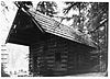
This is intended to be a complete list of the properties and districts on the National Register of Historic Places in Skagit County, Washington, United States. Latitude and longitude coordinates are provided for many National Register properties and districts; these locations may be seen together in a map. [1]

There are 30 properties and districts listed on the National Register in the county. Another property was once listed but has been removed.


    This National Park Service list is complete through NPS recent listings posted August 16, 2024. [2]

Current listings

[3] Name on the Register [4] ImageDate listed [5] Location City or townDescription
1 Anacortes Public Library
Anacortes Public Library Anacortes Public Library (now museum) 03.jpg
Anacortes Public Library
October 21, 1977
(#77001357)
1305 8th St.
48°30′56″N122°36′59″W / 48.515556°N 122.616389°W / 48.515556; -122.616389 (Anacortes Public Library)
Anacortes Carnegie Libraries of Washington TR (AD)
2 Backus-Marblemount Ranger Station House No. 1009
Backus-Marblemount Ranger Station House No. 1009 Marblemount No. 1009.jpg
Backus-Marblemount Ranger Station House No. 1009
February 10, 1989
(#88003462)
Ranger Station Rd., 1 mi. N of WA 20
48°32′25″N121°26′56″W / 48.540278°N 121.448889°W / 48.540278; -121.448889 (Backus-Marblemount Ranger Station House No. 1009)
Marblemount
3 Backus-Marblemount Ranger Station House No. 1010
Backus-Marblemount Ranger Station House No. 1010 Marblemount No. 1010.jpg
Backus-Marblemount Ranger Station House No. 1010
February 10, 1989
(#88003463)
Ranger Station Rd., 1 mi. N of WA 20
48°32′28″N121°26′51″W / 48.541111°N 121.4475°W / 48.541111; -121.4475 (Backus-Marblemount Ranger Station House No. 1010)
Marblemount
4 Baker River Bridge
Baker River Bridge Henry Thompson Bridge in Concrete, WA.jpg
Baker River Bridge
May 4, 1976
(#76001906)
On WA 17A, over Baker River
48°32′28″N121°44′34″W / 48.541111°N 121.742778°W / 48.541111; -121.742778 (Baker River Bridge)
Concrete Historic Bridges and Tunnels in Washington TR
5 Bethsaida Swedish Evangelical Lutheran Church Parsonage
Bethsaida Swedish Evangelical Lutheran Church Parsonage La Conner, WA - Bethsaida Lutheran Church parsonage 05.jpg
Bethsaida Swedish Evangelical Lutheran Church Parsonage
December 6, 1990
(#90001863)
1754 Chilberg Rd., Pleasant Ridge
48°23′29″N122°26′32″W / 48.391389°N 122.442222°W / 48.391389; -122.442222 (Bethsaida Swedish Evangelical Lutheran Church Parsonage)
La Conner
6 Burlington Carnegie Library
Burlington Carnegie Library Carnegie Libray Burlington.jpg
Burlington Carnegie Library
August 3, 1982
(#82004286)
901 Fairhaven St.
48°28′33″N122°19′18″W / 48.475833°N 122.321667°W / 48.475833; -122.321667 (Burlington Carnegie Library)
Burlington Carnegie Libraries of Washington TR
7 Burrows Island Light Station
Burrows Island Light Station Burrows Island Light.jpg
Burrows Island Light Station
August 9, 2024
(#100010694)
Far western shore of Burrows Island
48°28′41″N122°42′49″W / 48.4781°N 122.7136°W / 48.4781; -122.7136 (Burrows Island Light Station)
Anacortes vicinity
8 California Fruit Store
California Fruit Store Anacortes, WA - California Fruit Store 01.jpg
California Fruit Store
November 5, 1987
(#87001949)
909 Third St.
48°31′13″N122°36′37″W / 48.520278°N 122.610278°W / 48.520278; -122.610278 (California Fruit Store)
Anacortes
9 Causland Park
Causland Park Anacortes - Causland Park 05.jpg
Causland Park
May 7, 1981
(#81000589)
8th St. and M Ave.
48°30′59″N122°36′55″W / 48.516389°N 122.615278°W / 48.516389; -122.615278 (Causland Park)
Anacortes
10 Deception Pass
Deception Pass Deception pass bridge.jpg
Deception Pass
July 16, 1982
(#82004285)
Rte. 20
48°24′31″N122°38′37″W / 48.408611°N 122.643611°W / 48.408611; -122.643611 (Deception Pass)
Anacortes Historic Bridges and Tunnels in Washington TR, also extends into Island County
11 Fraternal Order of Eagles Hall-Anacortes
Fraternal Order of Eagles Hall-Anacortes Eagles Hall NRHP 100004790 Skagit County, WA.jpg
Fraternal Order of Eagles Hall-Anacortes
December 19, 2019
(#100004790)
901 Seventh St.
48°31′00″N122°36′41″W / 48.5166°N 122.6113°W / 48.5166; -122.6113 (Fraternal Order of Eagles Hall-Anacortes)
Anacortes
12 Gilbert's Cabin
Gilbert's Cabin Gilbert's Cabin.jpg
Gilbert's Cabin
February 10, 1989
(#88003453)
Cascade River Rd. W of Gilbert Creek
48°29′19″N121°05′20″W / 48.488611°N 121.088889°W / 48.488611; -121.088889 (Gilbert's Cabin)
Stehekin
13 Great Northern Depot
Great Northern Depot Anacortes, WA - Great Northern Depot 01.jpg
Great Northern Depot
November 5, 1987
(#87001935)
R Ave. & Seventh St.
48°31′02″N122°36′28″W / 48.517222°N 122.607778°W / 48.517222; -122.607778 (Great Northern Depot)
Anacortes
14 Hidden Lake Peak Lookout
Hidden Lake Peak Lookout Hidden Lake Peak Fire Lookout.JPG
Hidden Lake Peak Lookout
July 14, 1987
(#87001184)
Mt. Baker Ranger District, Southernmost peak of Hidden Lake Peaks near North Cascades National Park boundary
48°29′44″N121°12′15″W / 48.495556°N 121.204167°W / 48.495556; -121.204167 (Hidden Lake Peak Lookout)
Marblemount
15 La Conner Historic District
La Conner Historic District Downtown La Conner, WA 03.jpg
La Conner Historic District
April 24, 1974
(#74001977)
Roughly bounded by 2nd, Morris and Commercial Sts., and Snohomish Channel
48°23′25″N122°29′46″W / 48.390278°N 122.496111°W / 48.390278; -122.496111 (La Conner Historic District)
La Conner
16 LA MERCED
LA MERCED Anacortes, WA - La Merced, etc. 01.jpg
LA MERCED
April 17, 1990
(#90000588)
Anacortes Waterfront off Oakes Ave.
48°30′42″N122°38′45″W / 48.511667°N 122.645833°W / 48.511667; -122.645833 (LA MERCED)
Anacortes A schooner built in 1917; only its hull survives, as a breakwater for Lovric's boatyard on the north coast of Anacortes.
17 Lincoln Theater and Commercial Block
Lincoln Theater and Commercial Block Mount Vernon WA 03.jpg
Lincoln Theater and Commercial Block
November 5, 1987
(#87001987)
301-329 Kincaid St. & 710-740 First St.
48°25′04″N122°20′14″W / 48.417778°N 122.337222°W / 48.417778; -122.337222 (Lincoln Theater and Commercial Block)
Mount Vernon
18 Lower Baker River Hydroelectric Power Plant
Lower Baker River Hydroelectric Power Plant Lower Baker R Hydro Power Plant.jpg
Lower Baker River Hydroelectric Power Plant
July 17, 1990
(#88002736)
Baker River at S end of Shannan Lake
48°32′53″N121°44′24″W / 48.548056°N 121.74°W / 48.548056; -121.74 (Lower Baker River Hydroelectric Power Plant)
Concrete
19 Marine Supply and Hardware Complex
Marine Supply and Hardware Complex Anacortes - Marine Supply and Hardware Co. 01.jpg
Marine Supply and Hardware Complex
November 5, 1987
(#87001943)
202-218 Commercial Ave. & 1009 Second St.
48°31′14″N122°36′42″W / 48.520556°N 122.611667°W / 48.520556; -122.611667 (Marine Supply and Hardware Complex)
Anacortes
20 Birdsey D. Minkler House
Birdsey D. Minkler House Minkler House.jpg
Birdsey D. Minkler House
December 1, 1988
(#88002745)
201 S. Main St.
48°31′31″N122°03′30″W / 48.525278°N 122.058333°W / 48.525278; -122.058333 (Birdsey D. Minkler House)
Lyman
21 Northern State Hospital
Northern State Hospital Northern State Hospital.jpg
Northern State Hospital
December 20, 2010
(#10001043)
Roughly bounded by Thompson Dr. to the south, Hemlick Dr. to the east, Hub Dr. to the west, and 1/4 mile south of Mosier Rd. to the north.
48°31′50″N122°12′24″W / 48.530564°N 122.206581°W / 48.530564; -122.206581 (Northern State Hospital)
Sedro-Woolley
22 President Hotel
President Hotel Mount Vernon, WA - President Hotel.jpg
President Hotel
December 13, 2010
(#10001021)
310 Myrtle St.
48°25′07″N122°20′17″W / 48.418611°N 122.338056°W / 48.418611; -122.338056 (President Hotel)
Mount Vernon
23 Rock Cabin
Rock Cabin Rock Cabin WA NPS.jpg
Rock Cabin
February 10, 1989
(#88003457)
Fisher Creek Trail S of Diablo Lake
48°34′42″N120°59′47″W / 48.578333°N 120.996389°W / 48.578333; -120.996389 (Rock Cabin)
Diablo
24 Semar Block
Semar Block Semar Block site.jpg
Semar Block
November 5, 1987
(#87001967)
501 Q Ave.
48°31′07″N122°36′33″W / 48.518611°N 122.609167°W / 48.518611; -122.609167 (Semar Block)
Anacortes Demolished in 1999, now a parking lot.
25 Skagit City School
Skagit City School Skagit City School.jpg
Skagit City School
July 15, 1977
(#77001358)
3.5 mi. S of Mount Vernon on Moore Rd.
48°22′12″N122°21′59″W / 48.37°N 122.366389°W / 48.37; -122.366389 (Skagit City School)
Mount Vernon
26 Swamp-Meadow Cabin East
Swamp-Meadow Cabin East Swamp Meadow Cabin east.jpg
Swamp-Meadow Cabin East
February 10, 1989
(#88003456)
Thunder Creek Trail S of Diablo Lake
48°34′44″N121°01′05″W / 48.578889°N 121.018056°W / 48.578889; -121.018056 (Swamp-Meadow Cabin East)
Diablo
27 Swamp-Meadow Cabin West
Swamp-Meadow Cabin West Swamp Meadow Cabin west.jpg
Swamp-Meadow Cabin West
February 10, 1989
(#88003455)
Thunder Creek Trail S of Diablo Lake
48°34′44″N121°01′05″W / 48.578889°N 121.018056°W / 48.578889; -121.018056 (Swamp-Meadow Cabin West)
Diablo
28 US Post Office-Sedro Woolley Main
US Post Office-Sedro Woolley Main Sedro-Woolley Post Office 01.jpg
US Post Office-Sedro Woolley Main
August 7, 1991
(#91000655)
111 Woodworth St.
48°30′16″N122°14′18″W / 48.504444°N 122.238333°W / 48.504444; -122.238333 (US Post Office-Sedro Woolley Main)
Sedro-Woolley
29 W. T. PRESTON (snagboat)
W. T. PRESTON (snagboat) WTPreston.jpg
W. T. PRESTON (snagboat)
March 16, 1972
(#72001270)
Anacortes waterfront, R Ave., at foot of 7th St.
48°30′59″N122°36′29″W / 48.516389°N 122.608056°W / 48.516389; -122.608056 (W. T. PRESTON (snagboat))
Anacortes
30 Wilson Hotel
Wilson Hotel Anacortes - Historic Wilson Hotel.jpg
Wilson Hotel
December 15, 2004
(#04001369)
804 Commercial Ave.
48°31′03″N122°36′47″W / 48.5175°N 122.613056°W / 48.5175; -122.613056 (Wilson Hotel)
Anacortes 
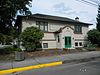
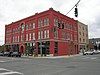
The hotel was designed by Pickles and Sutton of Tacoma, built of bricks from See's Brickyard of Anacortes. The style is Romanesque with masticated stone bases, rounded windows and Roman arches. The hotel was added to in 1927. Recently, the Wilson underwent complete restoration & earthquake retrofitting. The work was completed in 2007. The Wilson currently features retail on the main floor and low income housing on the upper floors.

Former listings

[3] Name on the RegisterImageDate listedDate removedLocation City or townDescription
1 Curtis Wharf
Curtis Wharf Curtiss Wharf.jpg
Curtis Wharf
November 10, 1987
(#87001941)
November 10, 1998Jct. of O Ave. & Second St.
Anacortes

See also

Related Research Articles

This is a list of the National Register of Historic Places listings in Washington County, Vermont.

<span class="mw-page-title-main">National Register of Historic Places listings in Washington County, New York</span>

List of the National Register of Historic Places listings in Washington County, New York

<span class="mw-page-title-main">National Register of Historic Places listings in Washington County, Pennsylvania</span>

This is a list of the National Register of Historic Places listings in Washington County, Pennsylvania.

<span class="mw-page-title-main">National Register of Historic Places listings in King County, Washington</span>

The following properties and districts in King County, Washington, United States, are on the National Register of Historic Places. Latitude and longitude coordinates are provided for many National Register properties and districts; these locations may be seen together in an online map.

<span class="mw-page-title-main">National Register of Historic Places listings in Washington County, Rhode Island</span>

This is a list of the National Register of Historic Places listings in Washington County, Rhode Island.

<span class="mw-page-title-main">National Register of Historic Places listings in Washington County, Ohio</span>

This is a list of the National Register of Historic Places listings in Washington County, Ohio.

<span class="mw-page-title-main">National Register of Historic Places listings in Thurston County, Washington</span>

This is a list of the National Register of Historic Places listings in Thurston County, Washington.

<span class="mw-page-title-main">National Register of Historic Places listings in Washington County, Maryland</span>

This is a list of the National Register of Historic Places listings in Washington County, Maryland.

<span class="mw-page-title-main">National Register of Historic Places listings in Washington County, Virginia</span>

This is a list of the National Register of Historic Places listings in Washington County, Virginia.

<span class="mw-page-title-main">National Register of Historic Places listings in Washington County, Florida</span>

This is a list of the National Register of Historic Places listings in Washington County, Florida.

<span class="mw-page-title-main">National Register of Historic Places listings in Washington County, Idaho</span>

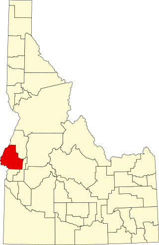
This is a list of the National Register of Historic Places listings in Washington County, Idaho.

This is a list of the National Register of Historic Places listings in Washington County, Tennessee.

<span class="mw-page-title-main">National Register of Historic Places listings in Scott County, Indiana</span>

This is a list of the National Register of Historic Places listings in Scott County, Indiana.

<span class="mw-page-title-main">National Register of Historic Places listings in Washington County, Indiana</span>

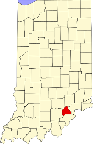
This is a list of the National Register of Historic Places listings in Washington County, Indiana.

<span class="mw-page-title-main">National Register of Historic Places listings in Jackson County, Indiana</span>

This is a list of the National Register of Historic Places listings in Jackson County, Indiana.

<span class="mw-page-title-main">National Register of Historic Places listings in Orange County, Indiana</span>

This is a list of the National Register of Historic Places listings in Orange County, Indiana.

<span class="mw-page-title-main">National Register of Historic Places listings in Crawford County, Indiana</span>

This is a list of the National Register of Historic Places listings in Crawford County, Indiana.

<span class="mw-page-title-main">National Register of Historic Places listings in Noble County, Ohio</span>

This is a list of the National Register of Historic Places listings in Noble County, Ohio.

This is a list of the National Register of Historic Places listings in North Cascades National Park.

<span class="mw-page-title-main">National Register of Historic Places listings in Washington County, North Carolina</span>

This list includes properties and districts listed on the National Register of Historic Places in Washington County, North Carolina. Click the "Map of all coordinates" link to the right to view a Google map of all properties and districts with latitude and longitude coordinates in the table below.

References

  1. The latitude and longitude information provided in this table was derived originally from the National Register Information System, which has been found to be fairly accurate for about 99% of listings. Some locations in this table may have been corrected to current GPS standards.
  2. National Park Service, United States Department of the Interior, "National Register of Historic Places: Weekly List Actions", retrieved August 16, 2024.
  3. 1 2 Numbers represent an alphabetical ordering by significant words. Various colorings, defined here, differentiate National Historic Landmarks and historic districts from other NRHP buildings, structures, sites or objects.
  4. "National Register Information System". National Register of Historic Places . National Park Service. April 24, 2008.
  5. The eight-digit number below each date is the number assigned to each location in the National Register Information System database, which can be viewed by clicking the number.