National Register of Historic Places listings in American Samoa

Last updated

American Samoa districts (clickable) American Samoa Districts.pngEastern DistrictManu'a DistrictWestern District
American Samoa districts (clickable)

This is a list of the buildings, sites, districts, and objects listed on the National Register of Historic Places in American Samoa. There are currently 31 listed sites spread across the three districts of American Samoa. There are no sites listed on the unorganized atoll of Swains Island.

Contents


    This National Park Service list is complete through NPS recent listings posted June 16, 2023. [1]

Numbers of listings

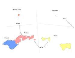
The following are approximate tallies of current listings in American Samoa on the National Register of Historic Places. These counts are based on entries in the National Register Information Database as of April 24, 2008 [2] and new weekly listings posted since then on the National Register of Historic Places web site. [3] There are frequent additions to the listings and occasional delistings and the counts here are not official. Also, the counts in this table exclude boundary increase and decrease listings which modify the area covered by an existing property or district and which carry a separate National Register reference number.

District# of Sites
1 Eastern 15
2 Manu'a 2
3 Rose Atoll 1
4Swains Island0
5 Western 13
Total:31

Eastern

[4] Name on the RegisterImageDate listed [5] Location VillageDescription
1 Blunts Point Naval Guns
Blunts Point Naval Guns WW II fortification hidden above harbour mouth - panoramio.jpg
Blunts Point Naval Guns
April 26, 1973
(#73002128)
Matautu Ridge
14°17′08″S170°40′36″W / 14.285556°S 170.676667°W / -14.285556; -170.676667 (Blunts Point Naval Guns)
Pago Pago
2 Breakers Point Naval Guns October 18, 1999
(#99001231)
Breakers Point
14°17′11″S170°39′30″W / 14.286389°S 170.658333°W / -14.286389; -170.658333 (Breakers Point Naval Guns)
Lauli'i
3 Courthouse of American Samoa
Courthouse of American Samoa High Court of American Samoa.jpg
Courthouse of American Samoa
February 12, 1974
(#74002180)
Near Pago Pago Harbor
14°16′41″S170°41′26″W / 14.277997°S 170.690459°W / -14.277997; -170.690459 (Courthouse of American Samoa)
Fagatogo
4 Government House
Government House GOVERNMENT HOUSE OR GOVERNOR'S MANSION.jpg
Government House
March 16, 1972
(#72001443)
Togotogo Ridge
14°16′38″S170°40′59″W / 14.277224°S 170.683006°W / -14.277224; -170.683006 (Government House)
Pago Pago
5 Michael J. Kirwan Educational Television Center October 23, 2009
(#09000842)
American Samoa Highway 118, north side of Utulei
14°16′41″S170°40′59″W / 14.278056°S 170.683056°W / -14.278056; -170.683056 (Michael J. Kirwan Educational Television Center)
Utulei
6 Lau'agae Ridge Quarry
Lau'agae Ridge Quarry Address restricted.PNG
Lau'agae Ridge Quarry
March 30, 2000
(#99001227)
Address restricted [6]
Tula
7 Governor H. Rex Lee Auditorium November 12, 2010
(#10000888)
American Samoa Highway 001, William McKinley Memorial Highway
14°16′44″S170°40′59″W / 14.278889°S 170.683056°W / -14.278889; -170.683056 (Governor H. Rex Lee Auditorium)
Utulei
8 Masefau Defensive Fortifications November 14, 2012
(#12000919)
Masefau Beach
14°15′26″S170°37′48″W / 14.257338°S 170.630119°W / -14.257338; -170.630119 (Masefau Defensive Fortifications)
Masefau
9 Navy Building 38 March 16, 1972
(#72001441)
Pago Pago Harbor
14°16′41″S170°41′19″W / 14.278056°S 170.688611°W / -14.278056; -170.688611 (Navy Building 38)
Fagatogo
10 Navy Building 43
Navy Building 43 Jean p haydon museum.png
Navy Building 43
March 16, 1972
(#72001442)
Pago Pago Harbor
14°16′40″S170°41′16″W / 14.277778°S 170.687778°W / -14.277778; -170.687778 (Navy Building 43)
Fagatogo Now the Jean P. Haydon Museum
11 Old Vatia November 2, 2006
(#06000956)
Above Vatia southwest of American Samoa Highway 015
14°15′13″S170°41′08″W / 14.253611°S 170.685556°W / -14.253611; -170.685556 (Old Vatia)
Vatia
12 Satala Cemetery October 19, 2006
(#05001110)
American Samoa Highway 001, west of Satala
14°16′14″S170°41′42″W / 14.270556°S 170.695°W / -14.270556; -170.695 (Satala Cemetery)
Lalopua
13 Sadie Thompson Building
Sadie Thompson Building SADIE THOMPSON BUILDING.jpg
Sadie Thompson Building
July 2, 2003
(#03000582)
Along main road
14°16′35″S170°41′35″W / 14.276389°S 170.693056°W / -14.276389; -170.693056 (Sadie Thompson Building)
Fagatogo
14 Tulauta Village
Tulauta Village Address restricted.PNG
Tulauta Village
June 2, 1997
(#87001980)
Address restricted [6]
Tula
15 U.S. Naval Station Tutuila Historic District
U.S. Naval Station Tutuila Historic District American Naval Base, Samoan Islands.png
U.S. Naval Station Tutuila Historic District
June 20, 1990
(#90000854)
South and west sides of Pago Pago Harbor
14°16′44″S170°41′09″W / 14.278889°S 170.685833°W / -14.278889; -170.685833 (U.S. Naval Station Tutuila Historic District)
Fagatogo and Utulei

Manu'a

[4] Name on the RegisterImageDate listed [5] Location VillageDescription
1 Faga Village Site
Faga Village Site Address restricted.PNG
Faga Village Site
November 23, 2003
(#99001228)
Address restricted [6]
Fitiuta
2 Tui Manu'a Graves Monument November 19, 2015
(#15000812)
Northwest of the junction of Ta'u Village and Ta'u Island Roads
14°13′41″S169°30′58″W / 14.228000°S 169.516100°W / -14.228000; -169.516100 (Tui Manu'a Graves Monument)
Ta'u

Rose Atoll

[4] Name on the RegisterImageDate listed [5] Location VillageDescription
1 Rose Island Concrete Monument
Rose Island Concrete Monument RoseIslandMarker.jpg
Rose Island Concrete Monument
December 18, 2013
(#13000920)
Approximately 160 feet (49 m) east of atoll lagoon
14°32′50″S168°08′43″W / 14.547210°S 168.145194°W / -14.547210; -168.145194 (Rose Island Concrete Monument)
Rose Atoll Concrete marker placed in 1920 during visit to atoll by Governor Terhune.

Western

[4] Name on the RegisterImageDate listed [5] Location VillageDescription
1 A'a Village (AS-34-33)
A'a Village (AS-34-33) Address restricted.PNG
A'a Village (AS-34-33)
November 19, 1987
(#87001956)
Address restricted [6]
Tapua'ina
2 Aasu
Aasu Death of Langle.png
Aasu
April 13, 1972
(#72001444)
Adjacent to Massacre Bay
14°17′33″S170°45′37″W / 14.292523°S 170.760301°W / -14.292523; -170.760301 (Aasu)
Aasu 
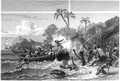
An armed confrontation between Samoans and French explorers from Lapérouse's expedition on this site in 1787 led to the deaths of 12 Frenchmen. News of the incident gave Samoans a reputation for ferocity among Europeans and deterred foreign intervention in Samoa for about a century. The French government placed a memorial at the site in 1883. [7]
3 Afao Beach Site November 14, 2012
(#12000916)
Afao Beach
14°19′56″S170°48′01″W / 14.332195°S 170.800226°W / -14.332195; -170.800226 (Afao Beach Site)
Afao
4 Atauloma Girls School
Atauloma Girls School Atauloma Girls School 3 - Afao American Samoa.jpg
Atauloma Girls School
March 16, 1972
(#72001445)
West edge of Afao
14°19′48″S170°48′06″W / 14.33°S 170.801667°W / -14.33; -170.801667 (Atauloma Girls School)
Afao The London Missionary Society opened this parochial school in 1900 as the second secondary school on Tutuila, and the first to admit girls. It prepared girls primarily to be pastors' wives, and after 1913 provided graduates to the nursing school at the naval station at Pago Pago. [8]
5 Fagalele Boys School
Fagalele Boys School Fagalele Boys School 1 - Leone American Samoa.jpg
Fagalele Boys School
March 16, 1972
(#72001446)
South of Leone
14°20′31″S170°47′10″W / 14.341944°S 170.786111°W / -14.341944; -170.786111 (Fagalele Boys School)
Leone 
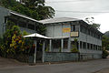
This 19th-century residential parochial school was built by the London Missionary Society for the primary purpose of educating future pastors, possibly as early as 1850. It was the first secondary school in what is now American Samoa, and it may be the oldest surviving building on Tutuila. [9]
6 Fagatele Bay Site
Fagatele Bay Site Address restricted.PNG
Fagatele Bay Site
June 2, 1997
(#87001958)
Address restricted [6]
Futiga
7 Malaeola Olo
Malaeola Olo Address restricted.PNG
Malaeola Olo
January 5, 2016
(#15000949)
Address restricted [6]
Malaeola Itu'au
8 Maloata Village
Maloata Village Address restricted.PNG
Maloata Village
June 12, 1997
(#87001955)
Address restricted [6]
Tapua'ina
9 Poloa Defensive Fortifications November 14, 2012
(#12000917)
Poloa Beach
14°18′59″S170°50′03″W / 14.316406°S 170.834151°W / -14.316406; -170.834151 (Poloa Defensive Fortifications)
Poloa Consisting of three pillboxes along the beach, these fortifications were built by American Marines as part of a system of defenses against a feared Japanese amphibious invasion of Samoa during the early part of World War II. [10]
10 Site AS-31-72
Site AS-31-72 Address restricted.PNG
Site AS-31-72
June 2, 1997
(#97000431)
Address restricted [6]
Faleniu
11 Tataga-Matau Fortified Quarry Complex (AS-34-10)
Tataga-Matau Fortified Quarry Complex (AS-34-10) Address restricted.PNG
Tataga-Matau Fortified Quarry Complex (AS-34-10)
November 19, 1987
(#87001957)
Address restricted [6]
Leone
12 Tupapa Site
Tupapa Site Address restricted.PNG
Tupapa Site
October 30, 2009
(#09000852)
Address restricted [6]
A'asufou
13 Turtle and Shark November 19, 2014
(#14000925)
2506 Turtle and Shark Road
14°21′26″S170°44′08″W / 14.357222°S 170.735555°W / -14.357222; -170.735555 (Turtle and Shark)
Vaitogi Site associated with an important event recounted in Samoan oral history.

See also

Related Research Articles

<span class="mw-page-title-main">National Register of Historic Places listings in Guam</span>

This is a list of the buildings, sites, districts, and objects listed on the National Register of Historic Places in Guam. There are currently 134 listed sites spread across 17 of the 19 villages of Guam. The villages of Agana Heights and Mongmong-Toto-Maite do not have any listings. Listed historic sites include Spanish colonial ruins, a few surviving pre-World War II ifil houses, Japanese fortifications, two massacre sites, and a historic district. Two other locations that were previously listed have been removed from the Register.

<span class="mw-page-title-main">National Register of Historic Places listings in Multnomah County, Oregon</span>

The following list presents the full set of National Register of Historic Places listings in Multnomah County, Oregon. However, please see separate articles for listings in each of Portland's six quadrants.

<span class="mw-page-title-main">National Register of Historic Places listings in Itasca County, Minnesota</span>

This is a list of the National Register of Historic Places listings in Itasca County, Minnesota. It is intended to be a complete list of the properties and districts on the National Register of Historic Places in Itasca County, Minnesota, United States. The locations of National Register properties and districts for which the latitude and longitude coordinates are included below, may be seen in an online map.

<span class="mw-page-title-main">National Register of Historic Places listings in Cass County, Minnesota</span>

This is a list of the National Register of Historic Places listings in Cass County, Minnesota. It is intended to be a complete list of the properties and districts on the National Register of Historic Places in Cass County, Minnesota, United States. The locations of National Register properties and districts for which the latitude and longitude coordinates are included below, may be seen in an online map.

<span class="mw-page-title-main">National Register of Historic Places listings in Douglas County, Minnesota</span>

This is a list of the National Register of Historic Places listings in Douglas County, Minnesota. It is intended to be a complete list of the properties and districts on the National Register of Historic Places in Douglas County, Minnesota, United States. The locations of National Register properties and districts for which the latitude and longitude coordinates are included below, may be seen in an online map.

<span class="mw-page-title-main">National Register of Historic Places listings in Big Horn County, Wyoming</span>

This is a list of the National Register of Historic Places listings in Big Horn County, Wyoming.

<span class="mw-page-title-main">National Register of Historic Places listings in Johnson County, Wyoming</span> National Register of Historic Places listings in Johnson

This is a list of the National Register of Historic Places listings in Johnson County, Wyoming. It is intended to be a complete list of the properties and districts on the National Register of Historic Places in Johnson County, Wyoming, United States. The locations of National Register properties and districts for which the latitude and longitude coordinates are included below, may be seen in an online map.

<span class="mw-page-title-main">National Register of Historic Places listings in Koochiching County, Minnesota</span>

This is a list of the National Register of Historic Places listings in Koochiching County, Minnesota. It is intended to be a complete list of the properties and districts on the National Register of Historic Places in Koochiching County, Minnesota, United States. The locations of National Register properties and districts for which the latitude and longitude coordinates are included below, may be seen in an online map.

<span class="mw-page-title-main">National Register of Historic Places listings in Mower County, Minnesota</span>

This is a list of the National Register of Historic Places listings in Mower County, Minnesota. It is intended to be a complete list of the properties and districts on the National Register of Historic Places in Mower County, Minnesota, United States. The locations of National Register properties and districts for which the latitude and longitude coordinates are included below, may be seen in an online map.

References

  1. National Park Service, United States Department of the Interior, "National Register of Historic Places: Weekly List Actions", retrieved June 16, 2023.
  2. "National Register Information System". National Register of Historic Places . National Park Service. April 24, 2008.
  3. "National Register of Historic Places: Weekly List Actions". National Park Service. Retrieved January 16, 2009.
  4. 1 2 3 4 Numbers represent an alphabetical ordering by significant words. Various colorings, defined here, differentiate National Historic Landmarks and historic districts from other NRHP buildings, structures, sites or objects.
  5. 1 2 3 4 The eight-digit number below each date is the number assigned to each location in the National Register Information System database, which can be viewed by clicking the number.
  6. 1 2 3 4 5 6 7 8 9 10 Federal and state laws and practices restrict general public access to information regarding the specific location of this resource. In some cases, this is to protect archeological sites from vandalism, while in other cases it is restricted at the request of the owner. See: Knoerl, John; Miller, Diane; Shrimpton, Rebecca H. (1990), Guidelines for Restricting Information about Historic and Prehistoric Resources, National Register Bulletin, National Park Service, U.S. Department of the Interior, OCLC   20706997 .
  7. Apple, Russell A. (May 25, 1971), National Register of Historic Places Inventory – Nomination Form: Aasu (PDF), retrieved November 27, 2014.
  8. Apple, Russell A. (July 9, 1971), National Register of Historic Places Inventory – Nomination Form: Atauloma Girls School (PDF), retrieved December 3, 2014.
  9. Apple, Russell A. (July 8, 1971), National Register of Historic Places Inventory – Nomination Form: Fagalele Boys School (PDF), retrieved September 1, 2014.
  10. Klenck, Joel D. (September 18, 2012), National Register of Historic Places Registration Form: Poloa (PDF), retrieved August 30, 2014.
Map all coordinates using: OpenStreetMap
Download coordinates as: KML