Courthouse of American Samoa

Last updated
Courthouse of American Samoa
High Court of American Samoa.jpg
American Samoa location map.svg
Red pog.svg
Location of the Courthouse in the Samoa archipelago
LocationNear Pago Pago Harbor, Fagatogo, American Samoa
Coordinates 14°16′41″S170°41′26″W / 14.277997°S 170.690459°W / -14.277997; -170.690459 Coordinates: 14°16′41″S170°41′26″W / 14.277997°S 170.690459°W / -14.277997; -170.690459
AreaLess than 1 acre (0.40 ha) [1]
Built1904
Part of U.S. Naval Station Tutuila Historic District [2] (ID90000854)
NRHP reference No. 74002180
Added to NRHPFebruary 12, 1974

The Courthouse of American Samoa, formerly Administration Building, Navy No. 21, is a historic building near Pago Pago Harbor in Fagatogo, American Samoa. It is a two-story wood-frame building mounted on concrete piers, with a two-story veranda on three sides. A concrete vault is located at the back of the building. The court house was reported by the local commander to have been completed about 1904. [2] It housed the offices and other facilities from which the United States Navy administered the island from its construction until 1952, and was where advisory councils (or fono) of the island's indigenous leaders were held. The building is one of the oldest standing in American Samoa, having survived typhoons and other perils. [1]

Contents

The building was added to the National Register of Historic Places in 1974. [3]

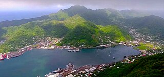
Description and Historic Significance

The Historical Commission could not find any record showing the exact time the Courthouse was erected. In July 1890, however, a careful research was conducted of the U.S. Navy’s projects and activities in American Samoa. Rear Admiral Kimberly U.S.N. was ordered to administer the survey of an establishment of a U.S. Coaling Station in Pago Pago. The following report is, therefore, based on the results of this research.

The Navy Department on August 5, 1898, commanded Civil Engineer Frank T. Chamber U.S.N., to advance to American Samoa for duty in connection with the erection of a wharf, a coal house, and other buildings at Pago Pago, Tutuila. The Commission is completely persuaded that the Courthouse was one of the establishments which were built under Chamber’s mission.

In March 1899, the Navy Department ordered Commander B.F. Tilley, U.S.N., Commanding Officer of the USS Abarenda (AC-13) which reached Pago Pago in the same year, to regard the instructions issued to the Civil Engineer Chamber. At the same time, the incumbent President of the United States sent several Americans to help with the construction of the wharf and buildings. Two of these men were Mr. Charles C. King and Mr. Joseph J. Jewett. Admiral Tilley who on 07 December 1899 left for Auckland, New Zealand to get materials for the implementation of the wharf and the buildings.

The Navy Department was notified on 25 July 1900 by the U.S. Post Office Department that a Post Office had been authorized at the U.S. Naval Station, Pago Pago, Tutuila. The Post Office was opened on 01 October 1900. Mrs. Hudson who was the wife of Chief Boatswain Hudson, U.S.N. became in-charge of the post office. She became the first Postmaster for Tutuila which is now known as American Samoa. Underneath the earliest Samoan hospital, the Post Office was built at Malaloa. 40 or 50 feet to the Pago Pago side of the Post Office stood Jewett’s house.

E.W. Gurr was a New Zealand lawyer and barrister. He was appointed by the Commandant as Secretary to the Commandant and also as Judge and Legal Adviser on 4 August 1900. Gurr’s services with the government of the island came to an end in 1908.

Interviews with a number of people whose ages from 55 to 93 years in both American Samoa and Western Samoa, denoted that the Courthouse took about three years to complete; and that numerous people from Western Samoa worked as carpenters in its construction.

When the Civil Engineer Chamber was assigned to erect the wharf, coal house and other buildings in Pago Pago in 1898, to October 1, 1900 when the first U.S. Post Office was opened by Mrs. Hudson, to the tour of duty of Commander E. B. Underwood, U.S. Navy, which started on May 5, 1903 and ended on 20 January 1905. It would be a close estimation that the construction of the Courthouse began some time in 1900 and completed either in the last part of 1903 or early in 1904. In arriving at this time estimate, the Commission also considered the employment of Mr. Gurr as a judge in August, 1900. He presided over cases which were held in nowhere else but the Courthouse for the Commission found no records to show that early trials had been held elsewhere.

After the completion of construction of the Courthouse, it was used at the time of the administration of the U.S. Navy, to house the offices of the Commandant-Governor, Chaplain, Disbursing Officer, Library, Aide to the Governor, in the upper floor. In the ground floor, there were offices of the Judge (who was also the Secretary of Native Affairs), the Attorney General, the Prosecutor, the Head of the Police Department), the Court Clerk, the Tax and Passport Clerk, the captain of the yard, and one spacious Courtroom.

Additionally, the Courtroom was used as an Assembly Hall or Meeting Place for the chiefs, leaders, and representatives from each village, county, and district of Tutuila and Manua, for their annual meetings called the FONO. This continued until the Enlisted Men’s barracks was assigned to the Legislature of American Samoa in 1954.

At present, the Courthouse is assigned to the exclusive use of the Court, or Judicial Department. It accommodates 2 papalagi Justice (Chief and Associate), and five Samoan judges. The building has two additional court rooms now, the old one is court room no. 1.

It is amazing that the Courthouse, one of the oldest buildings in American Samoa, has withstood the 20th Century in such good shape. It has been through a couple of World Wars, dozens of hurricanes, thousands of inches of tropical torrential downpours, millions of ants and cockroaches, termites and bugs. [2]


See also

Related Research Articles

<span class="mw-page-title-main">Pago Pago</span> Capital city of American Samoa

Pago Pago is the territorial capital of American Samoa. It is in Maoputasi County on Tutuila, which is American Samoa's main island.

<span class="mw-page-title-main">Flag of American Samoa</span> Official flag of the U.S. territory of American Samoa

The flag of American Samoa is a flag consisting of a red-edged white triangle pointing towards the hoist charged with a bald eagle clutching a war club and fly-whisk, with dark blue upper and lower triangles. Adopted in April 1960 to replace the "Stars and Stripes" as the official flag of the territory, it has been the flag of the Territory of American Samoa since that year. The colors used epitomize the traditional colors of the United States and Samoa.

<span class="mw-page-title-main">Tutuila</span> Largest island in American Samoa

Tutuila is the main island of American Samoa, and is part of the archipelago of Samoan Islands. It is the third largest island in the Samoan Islands chain of the Central Pacific. It is located roughly 4,000 kilometers (2,500 mi) northeast of Brisbane, Australia and lies over 1,200 kilometers (750 mi) to the northeast of Fiji. It contains a large, natural harbor, Pago Pago Harbor, where Pago Pago, the capital of American Samoa, is situated. Pago Pago International Airport is also located on Tutuila. The island’s land expanse is about 68% of the total land area of American Samoa. With 56,000 inhabitants, it is also home to 95% of the population of American Samoa. The island has six terrestrial and three marine ecosystems.

<span class="mw-page-title-main">Tripartite Convention</span> 1899 treaty ending the Second Samoan Civil War

The Tripartite Convention of 1899 concluded the Second Samoan Civil War, resulting in the formal partition of the Samoan archipelago into a German colony and a United States territory.

<span class="mw-page-title-main">History of American Samoa</span>

The islands of Samoa were originally inhabited by humans as early as 850 BC. After being invaded by European explorers in the 18th century, by the 20th and 21st century, the islands were incorporated into Samoa and American Samoa.

<span class="mw-page-title-main">American Samoa Fono</span> Territorial legislature of American Samoa

The American Samoa Fono is the territorial legislature of American Samoa. Like most states and territorial legislatures of the United States, it is a bicameral legislature with a House of Representatives and a Senate. The legislature is located in Fagatogo along Pago Pago harbor.

<span class="mw-page-title-main">Fagatogo</span> Village in American Samoa, United States

Fagatogo is the downtown area of Pago Pago. Located in the low grounds at the foot of Matafao Peak, it was the location of the first American settlement on Tutuila Island. It includes the sub-village of Malaloa. Today, Fagatogo is the government, commercial, financial, and shipping center of Tutuila. It is also the administrative capital of American Samoa. It is the location of the American Samoa Fono (legislature), and is listed in the Constitution of American Samoa as the territory's official seat of government. Its population is 1,737.

Utulei or ʻUtulei is a village in Maoputasi County, in the Eastern District of Tutuila, the main island of American Samoa. Utulei is traditionally considered to be a section of Fagatogo village, the legislative capital of American Samoa, and is located on the southwest edge of Pago Pago Harbor. Utulei is the site of many local landmarks: The A. P. Lutali Executive Office Building, which is next to the Feleti Barstow Library; paved roads that wind up to a former cablecar terminal on Solo Hill; the governor's mansion, which sits on Mauga o Alii, overlooking the entrance to Goat's Island, and the lieutenant governor's residence directly downhill from it; the Lee Auditorium, built in 1962; American Samoa's television studios, known as the Michael J. Kirwan Educational Television Center; and the Rainmaker Hotel. Utulei Terminal offers views of Rainmaker Mountain.

<span class="mw-page-title-main">Benjamin Franklin Tilley</span> US Navy Rear Admiral, Naval Acting-Governor

Benjamin Franklin Tilley was a career officer in the United States Navy who served from the end of the American Civil War through the Spanish–American War. He is best remembered as the first acting governor of American Samoa as well as the territory's first naval governor.

<span class="mw-page-title-main">Eastern District, American Samoa</span> District of American Samoa

The Eastern District is one of the primary districts of American Samoa. It consists of the eastern portion of Tutuila, American Samoa's largest island, plus the island of Aunu'u. The district has a land area of 67.027 km2 and a 2010 census population of 23,030. It contains 34 villages plus a portion of Nu'uuli village. Among these are Pago Pago, Fagatogo, and Utulei.

<span class="mw-page-title-main">Leone, American Samoa</span> Village in American Samoa, United States

Leone is the second-largest city on Tutuila Island's west coast. The village is on the south-west coast of Tutuila Island, American Samoa. Leone was the ancient capital of Tutuila Island. Leone was also where the Samoan Islands’ first missionary, John Williams, visited on October 18, 1832. A monument in honor of Williams has been erected in front of Zion Church. Its large church was the first to be built in American Samoa. It has three towers, a carved ceiling and stained glass. Until steamships were invented, Leone was the preferred anchorage of sailing ships which did not risk entering Pago Pago Harbor. Much early contact between Samoans and Europeans took place in Leone.

<span class="mw-page-title-main">United States Naval Station Tutuila</span>

United States Naval Station Tutuila was a naval station in Pago Pago Harbor on the island of Tutuila, part of American Samoa, built in 1899 and in operation until 1951. During the United States Navy rule of American Samoa, from 1900 to 1951, it was customary for the commandant of the station to also serve as Military Governor of the territory. Benjamin Franklin Tilley was the first commandant and the first officer responsible for the naval station's construction.

<span class="mw-page-title-main">Government House (American Samoa)</span> United States historic place

Government House, also known as Building No.1, Naval Station, Tutuila or Government House, U.S. Naval Station Tutuila, is a historic government building on the grounds of the former United States Naval Station Tutuila in Pago Pago, American Samoa. Built in 1903, it has served as a center of government on the island for much of the time since then. Government House was listed on the United States National Register of Historic Places in 1972, and was declared a National Historic Landmark in 1990.

<span class="mw-page-title-main">American Samoa</span> Territory of the United States

American Samoa is an unincorporated territory of the United States located in the South Pacific Ocean, southeast of the island country of Samoa. Its location is centered on 14.3°S 170.7°W. It is east of the International Date Line, while Samoa is west of the Line. The total land area is 199 square kilometers (76.8 sq mi), slightly more than Washington, D.C. American Samoa is the southernmost territory of the United States and one of two U.S. territories south of the Equator, along with the uninhabited Jarvis Island. Tuna products are the main exports, and the main trading partner is the rest of the United States.

Afao is a village in southwest Tutuila Island, American Samoa. It is located on the island's short southwestern coast, between 'Amanave and Leone, to the southwest of Pago Pago. It includes the settlement of Atauloma. Afao is home to two places listed on the U.S. National Register of Historic Places: Afao Beach Site and Atauloma Girls School.

<span class="mw-page-title-main">Jean P. Haydon Museum</span> United States historic place

The Jean P. Haydon Museum is a museum in Pago Pago dedicated to the culture and history of the United States territory of American Samoa. It contains a collection of canoes, coconut-shell combs, pigs’ tusk armlets and native pharmacopoeia. It also houses exhibits on natural history, tapa making, traditional tattooing, as well as a collection of war clubs, kava bowls, and historic photographs. Constructed in 1913 as U.S. Naval Station Tutuila Commissary, the building was home to Tutuila Island's Post Office from 1950 to 1971. The museum has displays of various aspects of the Samoan Islands’ culture and history. It is the official repository for collections of artifacts for American Samoa. Funded by the American Samoa Council on Arts, Culture and the Humanities, it is the venue used for numerous of the cultural resource activities in American Samoa.

<span class="mw-page-title-main">Maʻopūtasi County</span> County in American Samoa ----, United States

Maʻopūtasi County is located in the Eastern District of Tutuila Island in American Samoa. Maʻopūtasi County comprises the capital of Pago Pago and its harbor, as well as surrounding villages. It was home to 11,695 residents as of 2000. Maʻopūtasi County is 6.69 square miles (17.3 km2) The county has a 7.42-mile (11.94 km) shoreline which includes Pago Pago Bay.

Malaloa is a sub-village of Fagatogo and is located at the end of Pago Pago Harbor in American Samoa. It is located in-between Fagatogo proper and the village of Pago Pago. Cruising boats entering and leaving Pago Pago should clear at Malaloa Marina. The Malaloa Marina was opened for cruisers’ use and has added a customs wharf to handle inbound and outbound clearances.

<span class="mw-page-title-main">Naval Base Upolu</span> Naval base in United States

Naval Base Upolu was a naval base built by the United States Navy in 1942 to support the World War II effort. The base was located on Upolu Island, Samoa in the Western Pacific Ocean, part of the Samoan Islands's Naval Base Samoa. After the surprise attack on Naval Station Pearl Harbor on December 7, 1941, the US Navy was in need of setting up more advance bases in the Pacific Ocean. At Naval Base Upolu the Navy built a sea port, an airbase and a seaplane base.

<span class="mw-page-title-main">Naval Base Samoa</span> Naval base in United States

Naval Base Samoa, codename Operation Straw, was a number of United States Navy bases at American Samoa in the central Pacific Ocean. The bases were used during World War II to support the island hopping Pacific war efforts of the allied nations fighting the Empire of Japan.

References

  1. 1 2 Graf, Donald F. (June 12, 1973), National Register of Historic Places Inventory — Nomination Form: Courthouse of American Samoa (PDF), retrieved December 17, 2014
  2. 1 2 3 Thompson, Erwin N. (October 15, 1988), National Register of Historic Places Registration Form: U.S. Naval Station Tutuila Historic District (PDF), retrieved December 17, 2014
  3. "National Register Information System". National Register of Historic Places . National Park Service. July 9, 2010.