Kingman Reef is a largely submerged, uninhabited, triangle-shaped reef, geologically an atoll, 9.0 nmi (20 km) east-west and 4.5 nmi (8 km) north-south, in the North Pacific Ocean, roughly halfway between the Hawaiian Islands and American Samoa. It has an area of 3 hectares and is a unincorporated territory of the United States in Oceania. The reef is administered by the United States Fish and Wildlife Service as the Kingman Reef National Wildlife Refuge. It was claimed by the US in 1859, and later used briefly as stopover for commercial Pacific flying boat routes in the 1930s going to New Zealand; however, the route was changed with a different stopover. It was administered by the Navy from 1934 to 2000, and thereafter the Fish and Wildlife service. It has since become a marine protected area. In the 19th century it was noted as maritime hazard, earning the name Hazard Rocks, and is known to have been hit once in 1876. In the 21st century it has been noted for its marine biodiversity and remote nature. There are hundreds of species of fish and coral on and around the reef.

The United States Minor Outlying Islands is a statistical designation defined by the International Organization for Standardization's ISO 3166-1 code. The entry code is ISO 3166-2:UM. The minor outlying islands and groups of islands comprise eight United States insular areas in the Pacific Ocean and one in the Caribbean Sea.
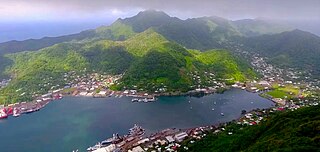
Pago Pago is the capital of American Samoa. It is in Maoputasi County on Tutuila, which is American Samoa's main island.

The Samoan Islands are an archipelago covering 3,030 km2 (1,170 sq mi) in the central South Pacific, forming part of Polynesia and of the wider region of Oceania. Administratively, the archipelago comprises all of the Independent State of Samoa and most of American Samoa. The land masses of the two Samoan jurisdictions are separated by 64 km (40 mi) of ocean at their closest points.
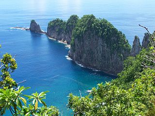
The National Park of American Samoa is a national park in the United States territory of American Samoa, distributed across four islands: Tutuila, Ofu, Olosega, and Ta‘ū. The park preserves and protects coral reefs, tropical rainforests, fruit bats, and the Samoan culture. Popular activities include hiking and snorkeling. Of the park's 8,257 acres (3,341 ha), 2,500 acres (1,000 ha) is coral reefs and ocean. The park is the only American National Park Service system unit south of the equator.

A U.S. National Marine Sanctuary is a zone within United States waters where the marine environment enjoys special protection. The program was established in 1972 by the Marine Protection, Research, and Sanctuaries Act and is currently administered by the National Ocean Service through the National Marine Sanctuaries Act (NMSA).

Tutuila is the largest and most populous island of American Samoa and is part of the archipelago of the Samoan Islands. It is the third largest island in the Samoan Islands chain of the Central Pacific. It is located roughly 4,000 kilometers (2,500 mi) northeast of Brisbane, Australia and lies over 1,200 kilometers (750 mi) to the northeast of Fiji. It contains a large, natural harbor, Pago Pago Harbor, where Pago Pago, the capital of American Samoa, is situated. Pago Pago International Airport is also located on Tutuila. The island's land expanse is about 68% of the total land area of American Samoa. With 56,000 inhabitants, it is also home to 95% of the population of American Samoa. The island has six terrestrial and three marine ecosystems.
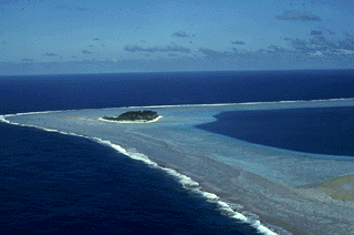
Rose Atoll, sometimes called Rose Island or Motu O Manu by people of the Manu'a Islands, is an oceanic atoll within the U.S. territory of American Samoa. An uninhabited wildlife refuge, it is the southernmost point belonging to the United States. The land area is just 0.05 km2 at high tide. The total area of the atoll, including lagoon and reef flat amounts to 6.33 km2. Just west of the northernmost point is a channel into the lagoon, about 80 m wide. There are two islets on the northeastern rim of the reef, larger Rose Island in the east and the non-vegetated Sand Island in the north. The Rose Atoll Marine National Monument that lies on the two outstanding islands of the Atoll is managed cooperatively between the U.S. Fish and Wildlife Service and the government of American Samoa.

Rose Atoll Marine National Monument is a United States National Monument in the South Pacific Ocean, covering 8,571,633 acres and encompassing the Rose Atoll National Wildlife Refuge, which was established in 1973 with 39,066 acres, only 20 acres (8.1 ha) of which is emergent. The monument's marine areas are likely to also be incorporated in the National Marine Sanctuary of American Samoa.

Rainmaker Mountain is the name of a mountain located near Pago Pago, American Samoa on Tutuila Island. Rainmaker Mountain traps rain clouds and gives Pago Pago the highest annual rainfall of any harbor. The average annual rainfall on the mountain is around 200 inches (510 cm). It has a three-pronged summit. Rainmaker Mountain and its base were designated a National Natural Landmark in 1972 due to the slopes’ tropical vegetation.
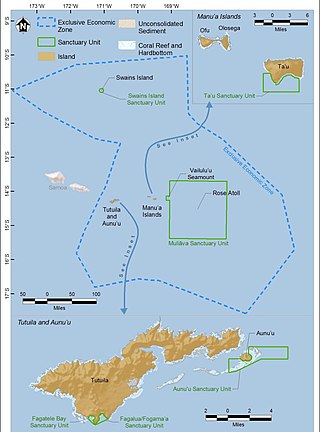
The National Marine Sanctuary of American Samoa is a federally-designated underwater area protected by the National Oceanic and Atmospheric Administration's (NOAA) Office of National Marine Sanctuaries. This sanctuary is the largest and most remote in the National Marine Sanctuary system. Spanning 13,581 sq mi, it is thought to be home to the greatest biodiversity of aquatic species of all the marine sanctuaries. Among them are expansive coral reefs, including some of the oldest Porites coral heads on earth, deep-water reefs, hydrothermal vent communities, and rare archeological resources. It was established in 1986, and then expanded and renamed in 2012.

The Pacific Remote Islands Marine National Monument is a group of unorganized, mostly unincorporated United States Pacific Island territories managed by the United States Fish and Wildlife Service of the United States Department of the Interior and the National Oceanic and Atmospheric Administration (NOAA) of the United States Department of Commerce. These remote refuges are "the most widespread collection of marine- and terrestrial-life protected areas on the planet under a single country's jurisdiction". They protect many endemic species including corals, fish, shellfish, marine mammals, seabirds, water birds, land birds, insects, and vegetation not found elsewhere.
Nuʻuuli is a village on the central east coast of Tutuila Island, American Samoa. It is located on a peninsula several miles up from Pago Pago International Airport. Nuʻuuli is located between Pago Pago International Airport and Coconut Point. It is a shopping district which is home to stores, groceries and many more shops.

Tafuna is a village in Tualauta County, Western District, American Samoa. It is the most populous village in American Samoa, with a population of 7,988 according to the 2020 U.S. Census, and is the center of nightlife on the island.

The following outline is provided as an overview of and topical guide to American Samoa:
American Samoa is an unincorporated territory of the United States located in the Polynesia region of the South Pacific Ocean. Centered on 14.3°S 170.7°W, it is 40 miles (64 km) southeast of the island country of Samoa, east of the International Date Line and the Wallis and Futuna Islands, west of the Cook Islands, north of Tonga, and some 310 miles (500 km) south of Tokelau. American Samoa is the southernmost territory of the United States, situated 2,200 miles (3,500 km) southwest of the U.S. state of Hawaii, and one of two U.S. territories south of the Equator, along with the uninhabited Jarvis Island.
Fagaʻalu is a village in central Tutuila Island, American Samoa. It is also known as Fagaʻalo. It is located on the eastern shore of Pago Pago Harbor, to the south of Pago Pago. American Samoa's lone hospital, Lyndon B. Johnson Tropical Medical Center, is located in Fagaʻalu. The village is centered around Fagaalu Stream.
Futiga is a village in the southwest of Tutuila Island, American Samoa. It is located inland, 7 miles (11 km) southwest of Pago Pago, between the villages of 'Ili'ili and Puapua. It is in Tualatai County.

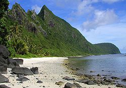
Vatia is a village on Tutuila Island in American Samoa. It is a north shore village located on Vatia Bay. The road to Vatia, American Samoa Highway 006, is the only road going through National Park of American Samoa. Vatia is a scenic community at the foot of Pola Ridge and surrounded by the national park. It is only reached by Route 6 which traverses the national park before reaching Vatia. There was once a hiking trail over Maugaloa Ridge from Leloaloa, but since the completion of Route 6, this trail is now overgrown. It is home to a beach, and panoramic views of jungle-covered peaks surround the village on all sides. Vatia is the center of the Tutuila-section of National Park of American Samoa. It is located in Vaifanua County.

Maʻopūtasi County is located in the Eastern District of Tutuila Island in American Samoa. Maʻopūtasi County comprises the capital of Pago Pago and its harbor, as well as surrounding villages. It was home to 11,695 residents as of 2000. Maʻopūtasi County is 6.69 square miles (17.3 km2) The county has a 7.42-mile (11.94 km) shoreline which includes Pago Pago Bay.