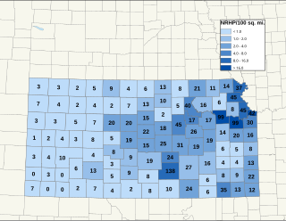
There are more than 1,500 properties and historic districts in the U.S. State of Colorado listed on the National Register of Historic Places. They are distributed over 63 of Colorado's 64 counties; only the City and County of Broomfield currently has none.
Contents
- Current listings by county
- Adams County
- Alamosa County
- Arapahoe County
- Archuleta County
- Baca County
- Bent County
- Former listing
- Boulder County
- City and County of Broomfield
- Chaffee County
- Cheyenne County
- Clear Creek County
- Conejos County
- Costilla County
- Crowley County
- Former listing 2
- Custer County
- Delta County
- City and County of Denver
- Dolores County
- Douglas County
- Eagle County
- El Paso County
- Elbert County
- Fremont County
- Garfield County
- Gilpin County
- Grand County
- Gunnison County
- Hinsdale County
- Huerfano County
- Jackson County
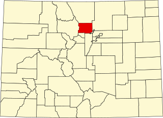
- Jefferson County
- Kiowa County
- Kit Carson County
- Former listing 3
- La Plata County
- Lake County
- Larimer County
- Las Animas County
- Lincoln County
- Logan County
- Mesa County
- Mineral County
- Moffat County
- Montezuma County
- Montrose County
- Morgan County
- Otero County
- Ouray County
- Park County
- Phillips County
- Pitkin County
- Prowers County
- Pueblo County
- Rio Blanco County
- Rio Grande County
- Routt County
- Saguache County
- San Juan County
- San Miguel County
- Sedgwick County
- Summit County
- Teller County
- Washington County
- Weld County
- Yuma County
- See also
- References
- External links
| Adams - Alamosa - Arapahoe - Archuleta - Baca - Bent - Boulder - Broomfield - Chaffee - Cheyenne - Clear Creek - Conejos - Costilla - Crowley - Custer - Delta - Denver - Dolores - Douglas - Eagle - El Paso - Elbert - Fremont - Garfield - Gilpin - Grand - Gunnison - Hinsdale - Huerfano - Jackson - Jefferson - Kiowa - Kit Carson - La Plata - Lake - Larimer - Las Animas - Lincoln - Logan - Mesa - Mineral - Moffat - Montezuma - Montrose - Morgan - Otero - Ouray - Park - Phillips - Pitkin - Prowers - Pueblo - Rio Blanco - Rio Grande - Routt - Saguache - San Juan - San Miguel - Sedgwick - Summit - Teller - Washington - Weld - Yuma |
This National Park Service list is complete through NPS recent listings posted August 9, 2024. [1]