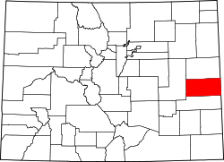
Cheyenne County, Colorado

Last updated

Cheyenne County
Cheyenne County Courthouse July 2020.jpg
Cheyenne County Colorado Courthouse
Map of Colorado highlighting Cheyenne County.svg
Location within the U.S. state of Colorado
Colorado in United States.svg
Colorado's location within the U.S.
Coordinates: 38°49′N102°35′W / 38.82°N 102.59°W / 38.82; -102.59
CountryFlag of the United States.svg United States
StateFlag of Colorado.svg  Colorado
FoundedMarch 25, 1889
Named for The Cheyenne Nation
Seat Cheyenne Wells
Largest townCheyenne Wells
Area
  Total1,781 sq mi (4,610 km2)
  Land1,778 sq mi (4,600 km2)
  Water3.2 sq mi (8 km2)  0.2%
Population
 (2020)
  Total1,748 [1]
  Density1.0/sq mi (0.4/km2)
Time zone UTC−7 (Mountain)
  Summer (DST) UTC−6 (MDT)
Congressional district 4th
Website www.co.cheyenne.co.us

Cheyenne County is a county located in the U.S. state of Colorado. The county population was 1,748 at 2020 census. [1] The county seat is Cheyenne Wells. [2]

Contents

History

Cheyenne County was created with its present borders by the Colorado State Legislature on March 25, 1889, out of portions of northeastern Bent County and southeastern Elbert County. It was named after the Cheyenne Indians who occupied eastern Colorado.

Geography

According to the U.S. Census Bureau, the county has a total area of 1,781 square miles (4,610 km2), of which 1,778 square miles (4,600 km2) is land and 3.2 square miles (8.3 km2) (0.2%) is water. [3]

The drainage basins in Cheyenne County include Bellyache, Big Timber, East and Middle Fork Big Spring, Eureka, Goose, Ladder, Little Spring, Pass, Rock, Sand, Turtle, White Woman, Wild Horse and Willow Creeks, as well as the Smoky Hill River. [4] The Smoky Hill drains into the Republican River in Kansas. The creeks in the northern and eastern part of the county drain to the Republican or Smoky Hill Rivers; those in the central and southeastern part of the county drain ultimately to the Arkansas River. All of the creeks in Cheyenne County are generally dry with some flow when drawing snowmelt or rainfall. There are four summits in Cheyenne County: Agate Mound (4,457 ft.), Eureka Hill (4,700 ft.), Landsman Hill (4,695 ft.), and Twin Buttes (4,621 ft.) [5] The highest point in the county is in the extreme northwest corner of the county on the Bledsoe Ranch (5,255 ft.) [6]

Adjacent counties

Major highways

Antipode

Cheyenne County is home of the Antipode of Île Saint-Paul making it one of the few places in the continental United States with a non-oceanic antipode. [7] [8]

Demographics

Historical population
CensusPop.Note
1890 534
1900 501−6.2%
1910 3,687635.9%
1920 3,7461.6%
1930 3,723−0.6%
1940 2,964−20.4%
1950 3,45316.5%
1960 2,789−19.2%
1970 2,396−14.1%
1980 2,153−10.1%
1990 2,39711.3%
2000 2,231−6.9%
2010 1,836−17.7%
2020 1,748−4.8%
2023 (est.)1,727 [9] −1.2%
U.S. Decennial Census [10]
1790-1960 [11] 1900-1990 [12]
1990-2000 [13] 2010-2020 [1]

As of the census [14] of 2000, there were 2,231 people, 880 households, and 602 families residing in the county. The population density was 1 people per square mile (0.39 people/km2). There were 1,105 housing units at an average density of 1 units per square mile (0.39 units/km2). The racial makeup of the county was 92.87% White, 0.49% Black or African American, 0.76% Native American, 0.13% Asian, 5.11% from other races, and 0.63% from two or more races. 8.11% of the population were Hispanic or Latino of any race.

There were 880 households, out of which 34.10% had children under the age of 18 living with them, 59.30% were married couples living together, 5.70% had a female householder with no husband present, and 31.50% were non-families. 29.00% of all households were made up of individuals, and 12.40% had someone living alone who was 65 years of age or older. The average household size was 2.50 and the average family size was 3.12.

In the county, the population was spread out, with 28.80% under the age of 18, 7.10% from 18 to 24, 26.20% from 25 to 44, 21.30% from 45 to 64, and 16.60% who were 65 years of age or older. The median age was 38 years. For every 100 females there were 100.60 males. For every 100 females age 18 and over, there were 98.40 males.

The median income for a household in the county was $37,054, and the median income for a family was $44,394. Males had a median income of $32,250 versus $19,286 for females. The per capita income for the county was $17,850. About 8.70% of families and 11.10% of the population were below the poverty line, including 12.90% of those under age 18 and 10.90% of those age 65 or over.

Communities

Cheyenne County, Colorado Map of Cheyenne County, Colorado.png
Cheyenne County, Colorado

Towns

Census Designated Place

Unincorporated communities

Politics

United States presidential election results for Cheyenne County, Colorado [15]
Year Republican Democratic Third party
No.%No.%No.%
2020 99387.41%13111.53%121.06%
2016 92583.94%13211.98%454.08%
2012 88981.34%17215.74%322.93%
2008 89080.11%19817.82%232.07%
2004 92381.39%19817.46%131.15%
2000 95778.96%20917.24%463.80%
1996 73962.84%32827.89%1099.27%
1992 61550.74%30124.83%29624.42%
1988 76064.08%39933.64%272.28%
1984 89273.23%30725.21%191.56%
1980 81665.86%32225.99%1018.15%
1976 61048.15%62549.33%322.53%
1972 81563.37%40031.10%715.52%
1968 66455.70%39232.89%13611.41%
1964 54542.48%73557.29%30.23%
1960 80665.69%41934.15%20.16%
1956 82061.70%50738.15%20.15%
1952 1,00465.97%51533.84%30.20%
1948 65747.40%71351.44%161.15%
1944 92360.68%59439.05%40.26%
1940 91554.43%75845.09%80.48%
1936 76744.85%90352.81%402.34%
1932 74639.41%1,04255.04%1055.55%
1928 94563.85%50033.78%352.36%
1924 87555.70%23615.02%46029.28%
1920 84064.57%35827.52%1037.92%
1916 55838.38%80255.16%946.46%
1912 23717.66%50737.78%59844.56%

Since the 1920s, Cheyenne County has mostly supported Republican candidates in presidential elections. In the 25 presidential elections since 1920, the Democratic presidential candidates have carried the county only five times, none have broken 60% of the vote, and only Lyndon Johnson in 1964, and Franklin Delano Roosevelt in 1932 won the county by a double-digit margin. By contrast, the Republican nominees have carried the county 20 times, including the last ten in a row, with all except Wendell Willkie in 1940 winning by at least a double-digit margin. The four most recent GOP presidential candidates George W. Bush, John McCain, Mitt Romney, and Donald Trump all carried Cheyenne county with over 80% of the vote.

Historic Trails

Historic Sites

See also

Notes

    Related Research Articles

    <span class="mw-page-title-main">Pawnee County, Kansas</span> County in Kansas, United States

    Pawnee County is a county located in the U.S. state of Kansas. Its county seat and largest city is Larned. As of the 2020 census, the county population was 6,253. The county is named after the Pawnee tribe.

    <span class="mw-page-title-main">Cheyenne County, Kansas</span> County in Kansas, United States

    Cheyenne County is a county located in the northwest corner of the U.S. state of Kansas. Its county seat and most populous city is St. Francis. As of the 2020 census, the county population was 2,616. The county was named after the Cheyenne tribe.

    <span class="mw-page-title-main">Yuma County, Colorado</span> County in Colorado, United States

    Yuma County is a county located in the U.S. state of Colorado. As of the 2020 census, the population was 9,988. The county seat is Wray.

    <span class="mw-page-title-main">Sedgwick County, Colorado</span> County in Colorado, United States

    Sedgwick County is a county located in the U.S. state of Colorado. As of the 2020 census, the population was 2,404. The county seat is Julesburg. The county was named for Fort Sedgwick, a military post along the Platte Trail, which was named for General John Sedgwick. It is located near the state border with Nebraska.

    <span class="mw-page-title-main">Prowers County, Colorado</span> County in Colorado, United States

    Prowers County is a county located in the U.S. state of Colorado. As of the 2020 census, the population was 11,999. The county seat is Lamar. The county is named in honor of John Wesley Prowers, a leading pioneer in the lower Arkansas River valley region.

    <span class="mw-page-title-main">Lincoln County, Colorado</span> County in Colorado, United States

    Lincoln County is a county located in the U.S. state of Colorado. As of the 2020 census, the population was 5,675. The county seat is Hugo. The county obtains its name in memory of the United States President Abraham Lincoln. County was formed from portions of Bent and Elbert counties in 1889 from a restructuring of Colorado counties.

    <span class="mw-page-title-main">Kit Carson County, Colorado</span> County in Colorado, United States

    Kit Carson County is a county located in the U.S. state of Colorado. As of the 2020 census, the population was 7,087. The county seat is Burlington. The county was established in 1889 and named for American frontiersman and Indian fighter Kit Carson.

    <span class="mw-page-title-main">Elbert County, Colorado</span> County in the United States

    Elbert County is a county located in the U.S. state of Colorado. As of the 2020 census, the population was 26,062. The county seat is Kiowa and the largest town is Elizabeth.

    <span class="mw-page-title-main">El Paso County, Colorado</span> County in Colorado, United States

    El Paso County is the most populous county located in the American state of Colorado. As of the 2020 Census, the population was 730,395, surpassing the City and County of Denver. The county seat is Colorado Springs, the second most populous city in Colorado. El Paso County is included in the Colorado Springs, Colorado, Metropolitan Statistical Area.

    <span class="mw-page-title-main">Arapahoe County, Colorado</span> County in Colorado, United States

    Arapahoe County is a county located in the U.S. state of Colorado. As of the 2020 census, its population was 655,070, making it the third-most populous county in Colorado. The county seat is Littleton, and the most populous city is Aurora. The county was named for the Arapaho Native American tribe, who once lived in the region.

    <span class="mw-page-title-main">Salina, Kansas</span> City in Saline County, Kansas

    Salina is a city in and the county seat of Saline County, Kansas, United States. As of the 2020 census, the population was 46,889.

    <span class="mw-page-title-main">Franklin, Missouri</span> City in Missouri, United States

    Franklin is a city in Howard County, Missouri, United States. It is located along the Missouri River in the central part of the state. Located in a rural area, the city had a population of 70 at the 2020 census. It is part of the Columbia, Missouri Metropolitan Statistical Area.

    <span class="mw-page-title-main">Smoky Hill River</span> River in the United States

    The Smoky Hill River is a 575-mile (925 km) river in the central Great Plains of North America, running through Colorado and Kansas.

    <span class="mw-page-title-main">Jim Baker (frontiersman)</span> American explorer

    Jim Baker (1818–1898), known as "Honest Jim Baker", was a frontiersman, trapper, hunter, army scout, interpreter, and rancher. He was first a trapper and hunter. The decline of the fur trade in the early 1840s drove many trappers to quit, but Baker remained in the business until 1855. During that time he was a friend of Jim Bridger, Kit Carson and John C. Frémont. On August 21, 1841, he was among a group of twenty three trappers who were attacked by Arapaho, Cheyenne, and Sioux on what became known as Battle Mountain. After Henry Fraeb was killed, Baker organized the trappers against the Native Americans in a multiple-day fight.

    <span class="mw-page-title-main">Solomon River</span> River in Kansas, United States

    The Solomon River, often referred to as the "Solomon Fork", is a 184-mile-long (296 km) river in the central Great Plains of North America. The entire length of the river lies in the U.S. state of Kansas. It is a tributary of the Smoky Hill River.

    <span class="mw-page-title-main">Saline River (Kansas)</span> River in the United States

    The Saline River is a 397-mile-long (639 km) tributary of the Smoky Hill River in the central Great Plains of North America. The entire length of the river lies in the U.S. state of Kansas in the northwest part of the state. Its name comes from the French translation of its Native name Ne Miskua, referring to its salty content.

    <span class="mw-page-title-main">K-27 (Kansas highway)</span> Highway in Kansas

    K-27 is an approximately 226-mile-long (364 km) north–south state highway that parallels Kansas' western border with Colorado. It is the westernmost north–south state highway in the state. It begins at U.S. Route 56 (US-56) in Elkhart near the Oklahoma state line and travels through the seven counties that border Colorado until reaching its northern terminus north of St. Francis, where it ends at the Nebraska state line. Along the way, it intersects several major highways, including US-160 in Johnson City, US-50 and US-400 in Syracuse, US-40 in Sharon Springs, Interstate 70 (I-70) and US-24 in Goodland, and US-36 in Wheeler. The section from US-40 north to Nebraska, is designated as the Land and Sky Scenic Byway. K-27 changes time zones twice, during its trek through Kansas, the only highway in the state to do so.

    <span class="mw-page-title-main">McPherson Township, Sherman County, Kansas</span>

    McPherson Township is one of the thirteen townships of Sherman County, Kansas, United States. The population was 52 at the 2000 census.

    <span class="mw-page-title-main">North Fork Smoky Hill River</span> River in Kansas, United States

    The North Fork Smoky Hill River is a river in the central Great Plains of North America. A tributary of the Smoky Hill River, it flows from eastern Colorado into western Kansas.

    Sheridan is a ghost town in Logan County, Kansas, United States. Founded in 1868 at the western terminus of an important railroad line under construction, it served as a regional center of trade and departure point to the Santa Fe Trail to the south. In 1870, the local population abandoned the settlement due to the extension of the railroad west to Kit Carson, Colorado. During its brief existence, Sheridan earned a reputation for violence and lawlessness characteristic of the American frontier.

    References

    1. 1 2 3 "U.S. Census Bureau QuickFacts". U.S. Census Bureau . Retrieved September 4, 2021.
    2. "Find a County". National Association of Counties. Archived from the original on May 9, 2015. Retrieved June 7, 2011.
    3. "US Gazetteer files: 2010, 2000, and 1990". United States Census Bureau. February 12, 2011. Retrieved April 23, 2011.
    4. Cheyenne County Physical Features. Colorado Home Town Locator. "Cheyenne County Colorado Streams". Archived from the original on March 4, 2016. Retrieved November 16, 2012.
    5. Cheyenne County: PlaceNames.com "Cheyenne County, Colorado, USA - Summits - Place Names". Archived from the original on June 10, 2013. Retrieved November 17, 2012.
    6. Colorado Peak Statistics. ""Bledsoe Ranch Road", CO 5,255'". Archived from the original on March 3, 2016. Retrieved November 17, 2012.
    7. "Antipodes Map (AKA Tunnel Map)". www.findlatitudeandlongitude.com. Archived from the original on February 14, 2018. Retrieved May 3, 2018.
    8. "United States Antipodes". www.weathergraphics.com. Archived from the original on January 4, 2018. Retrieved May 3, 2018.
    9. "Annual Estimates of the Resident Population for Counties: April 1, 2020 to July 1, 2023". United States Census Bureau. Retrieved March 31, 2024.
    10. "U.S. Decennial Census". United States Census Bureau. Retrieved June 7, 2014.
    11. "Historical Census Browser". University of Virginia Library. Archived from the original on August 11, 2012. Retrieved June 7, 2014.
    12. "Population of Counties by Decennial Census: 1900 to 1990". United States Census Bureau. Archived from the original on July 31, 2014. Retrieved June 7, 2014.
    13. "Census 2000 PHC-T-4. Ranking Tables for Counties: 1990 and 2000" (PDF). United States Census Bureau. Archived (PDF) from the original on December 18, 2014. Retrieved June 7, 2014.
    14. "U.S. Census website". United States Census Bureau . Retrieved May 14, 2011.
    15. Leip, David. "Dave Leip's Atlas of U.S. Presidential Elections". uselectionatlas.org. Archived from the original on June 4, 2011. Retrieved May 26, 2017.
    16. History: Cheyenne County. COGenWeb. "History - Cheyenne CountyCOGenWeb". Archived from the original on January 6, 2009. Retrieved March 2, 2008.
    17. Historic Sites in Cheyenne County. COGenWeb.http://cogenweb.com/cheyenne/cheyhist.htm

    38°49′N102°35′W / 38.82°N 102.59°W / 38.82; -102.59