
Longmont is a home rule municipality located in Boulder and Weld counties, Colorado, United States. Its population was 98,885 as of the 2020 U.S. Census. Longmont is located northeast of the county seat of Boulder. It is named after Longs Peak, a prominent mountain that is clearly visible from the city.

Berthoud is a statutory town located in Larimer and Weld counties, Colorado, United States. The town population was 10,332 at the 2020 United States Census with 10,071 residing in Larimer County and 261 residing in Weld County. Berthoud is situated north of the Little Thompson River, 21 miles (34 km) south of Fort Collins and 43 miles (69 km) north of Denver in the Front Range Urban Corridor.

Denver International Airport — locally known as DIA — is an international airport in the Western United States, primarily serving metropolitan Denver, Colorado, as well as the greater Front Range Urban Corridor. At 33,531 acres, it is the largest airport in the Western Hemisphere by land area and the second largest on Earth, behind King Fahd International Airport. Runway 16R/34L, with a length of 16,000 feet, is the longest public use runway in North America and the seventh longest on Earth. The airport is 25 miles (40 km) driving distance northeast of Downtown Denver, 19 miles (31 km) farther than the former Stapleton International Airport which DEN replaced; the airport is actually closer to the City of Aurora than central Denver, and many airport-related services, such as hotels, are located in Aurora.
FasTracks is a multibillion-dollar public transportation expansion plan under construction in metropolitan Denver, Colorado, United States. Developed by the Regional Transportation District (RTD), the plan consists of new commuter rail, light rail, and express bus services. Six new light rail, electric commuter rail and diesel commuter rail lines with a combined length of 122 miles (196 km) will be constructed under the plan. It expands on previous transportation projects, notably T-REX, and includes 57 new transit stations and stops, 21,000 new parking spaces, 18 miles (29 km) of a bus service between Denver and Boulder and the renovation of Denver Union Station as a multi-modal transportation hub.
The Regional Transportation District, more commonly referred to as RTD, is the regional agency operating public transit services in eight out of the twelve counties in the Denver–Aurora combined statistical area in the U.S. state of Colorado. It operates over a 2,342-square-mile (6,070 km2) area, serving 3.08 million people. RTD was organized in 1969 and is governed by a 15-member, publicly elected Board of Directors. Directors are elected to a four-year term and represent a specific district of about 180,000 constituents.

The City and County of Denver, Colorado, is located at 39°43'35" North, 104°57'56" West in the Colorado Front Range region. The Southern Rocky Mountains lie to the west of Denver and the High Plains lie to the east.

The Roaring Fork Transportation Authority is an agency that operates public transportation for the Roaring Fork Valley in Colorado. RFTA's service area stretches 70 miles (110 km) from Aspen to Rifle, serving the towns in between consisting of Basalt, Snowmass Village, Carbondale, Glenwood Springs, New Castle, and Silt. RFTA also operates seasonal ski shuttles, Maroon Bells Shuttles, Paratransit, and manages 41 miles of the Rio Grande Trail.

Arapahoe at Village Center station is a light rail station in Greenwood Village, Colorado, United States. It is served by the E and R Lines, operated by the Regional Transportation District (RTD), and was opened on November 17, 2006. In addition to numerous office buildings and corporate campuses, the station is the destination for people attending concerts at the Fiddler's Green Amphitheatre. The station also serves as the terminus for the SkyRide AT bus route, with service to Denver International Airport, and is also served by the Bustang Denver Technology Center (DTC) service. The station features a public art installation of a trio of sculptures entitled Nucleus. It was created by Michael Clapper and dedicated in 2010.

Interstate 70 (I-70) is a transcontinental Interstate Highway in the United States, stretching from Cove Fort, Utah, to Baltimore, Maryland. In Colorado, the highway traverses an east–west route across the center of the state. In western Colorado, the highway connects the metropolitan areas of Grand Junction and Denver via a route through the Rocky Mountains. In eastern Colorado, the highway crosses the Great Plains, connecting Denver with metropolitan areas in Kansas and Missouri. Bicycles and other non-motorized vehicles, normally prohibited on Interstate Highways, are allowed on those stretches of I-70 in the Rockies where no other through route exists.

The Transportation Expansion (T-REX) Project was a $1.67 billion project aimed at improving transportation options for commuters in the Denver metro area within the areas of Interstate 25 and 225, which was recognized as the 14th busiest intersection in the United States at the time. The T-REX effort widened major interstates to up to 5 mainline lanes in each direction and added 19 miles (31 km) of double-track light rail throughout the metropolitan area. The T-REX project finished 3.2% under its $1.67 billion budget and 22 months ahead of schedule in 2006.
In the US state of Colorado, Interstate 25 (I-25) follows the north–south corridor through Colorado Springs and Denver. The highway enters the state from the north near Carr and exits the state near Starkville. The highway also runs through the cities of Fort Collins, Broomfield, Loveland, and Pueblo. The route is concurrent with U.S. Route 87 (US 87), which is unsigned, through the entire length of the state. I-25 replaced US 87 and most of US 85 for through traffic.

The Colorado Department of Transportation is the principal department of the Colorado state government that administers state government transportation responsibilities in the state of Colorado. CDOT is responsible for maintaining 9,144 mile highway system, including 3,429 bridges with over 28 billion vehicle miles of travel per year. CDOT's Mission is "To provide the best multi-modal transportation system for Colorado that most effectively moves people, goods, and information." It is governed by the Transportation Commission of Colorado.

Transfort is the public transportation operator for the City of Fort Collins, Colorado. The system offers 22 regular routes, with 20 of them providing all-day service Monday through Friday. Six-day intercity service is provided by the FLEX to Loveland, Berthoud, and Longmont. Additionally, five routes for transporting Colorado State University students, faculty and staff run throughout the school year. In 2023, the system provided transportation services to 2,086,500 people.

The A Line is a Regional Transportation District (RTD) commuter rail line serving Denver and Aurora, Colorado, operating between downtown Denver and Denver International Airport (DIA). During planning and construction, it was also known as the East Rail Line, but most locals refer to it as the A Line. Despite its former title, the line does not serve the campuses of the University of Colorado.
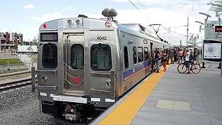
The B Line, also known as the Northwest Rail Line during construction, is a commuter rail line which is part of the commuter and light rail system operated by the Regional Transportation District in the Denver metropolitan area in Colorado. Part of the FasTracks project, the first 6.2-mile (10 km) section from downtown Denver to south Westminster opened on July 25, 2016. If fully built out, estimated around 2042, the B Line will be a 41-mile (66 km) high-capacity route from Denver Union Station to Longmont, passing through North Denver, Adams County, Westminster, Broomfield, Louisville and Boulder.

The Front Range Urban Corridor is an oblong region of urban population located along the eastern face of the Southern Rocky Mountains, encompassing 18 counties in the US states of Colorado and Wyoming. The corridor derives its name from the Front Range, the mountain range that defines the western boundary of the corridor which serves as a gateway to the Rocky Mountains. The region comprises the northern portion of the Southern Rocky Mountain Front geographic area, which in turn comprises the southern portion of the Rocky Mountain Front geographic area of Canada and the United States. The Front Range Urban Corridor had a population of 5,055,344 at the 2020 Census, an increase of +16.65% since the 2010 Census.

Flatiron Flyer is an 18-mile (29 km) express bus system between Denver, Aurora, and Boulder, Colorado, traveling along U.S. Route 36. Different levels of service are available, including a non-stop from Boulder to Union Station in high-occupancy toll lanes, and all-stop, which serves six park-and-rides along U.S. Route 36 in normal highway lanes. The line branches out to different destinations in Denver, Aurora and Boulder. The Regional Transportation District operates the line, opened on January 3, 2016.

Denver Airport is a commuter rail station on the A Line in Denver, Colorado, serving Denver International Airport. The A Line begins at the airport and travels west to Union Station in Downtown Denver in about 27 minutes via six intermediate stops. Trains run about every 15 minutes.

Peoria station, also known as Peoria/Smith station, is a Regional Transportation District (RTD) station in Aurora, Colorado. The station is served by the A Line, a commuter rail line from Union Station in Downtown Denver to Denver International Airport, and the R Line, a light rail line crossing through Aurora and South to Lone Tree. A Line travel times from the station to Downtown Denver and Denver International Airport are about 17 and 20 minutes, respectively. Peoria station is the northern terminus of the R Line with a travel time of 58 minutes to the southern terminus at Lincoln station.


