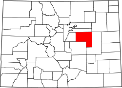
{{Infobox U.S. county | county = Elbert County | state = Colorado | ex image = St. Mark United Presbyterian Church 04.JPG | ex image size = 220px | ex image cap = [[St. Mark United Presbyterian Church]
[Elbert, Colorado]]. | seal = | founded year = 1874 | founded date = February 2 | seat wl = Kiowa | largest city wl = Elizabeth | city type = town | area_total_sq_mi = 1851 | area_land_sq_mi = 1851 | area_water_sq_mi = 0.2 | area percentage = 0.01% | census yr = 2020 | pop = 26062 | pop_est_as_of = 2023 | population_est = 28806 | density_sq_mi = auto | time zone = Mountain | footnotes = | web = www.elbertcounty-co.gov | named for = Samuel Hitt Elbert | district = 4th }}
Elbert County is a county located in the U.S. state of Colorado. As of the 2020 census, the population was 26,062. [1] The county seat is Kiowa and the largest town is Elizabeth. [2] Elbert County is included in the Denver-Aurora-Lakewood, CO Metropolitan Statistical Area.
Elbert County was created on February 2, 1874, from the eastern portions of Douglas County. On February 6, 1874, the county was enlarged to include part of northern Greenwood County upon Greenwood's dissolution, and originally extended south and east of its present boundaries to reach to the Kansas state line. The county was named for Samuel Hitt Elbert, [3] the Governor of the Territory of Colorado when the county was formed. In 1889, Elbert County was reduced to its modern size when its eastern portions were taken to create Lincoln, Kit Carson, and Cheyenne counties.
According to the U.S. Census Bureau, the county has a total area of 1,851 square miles (4,790 km2), of which 1,851 square miles (4,790 km2) is land and 0.2 square miles (0.52 km2) (0.01%) is water. [4]
Census | Pop. | Note | %± |
---|---|---|---|
1880 | 1,708 | — | |
1890 | 1,856 | 8.7% | |
1900 | 3,101 | 67.1% | |
1910 | 5,331 | 71.9% | |
1920 | 6,980 | 30.9% | |
1930 | 6,580 | −5.7% | |
1940 | 5,460 | −17.0% | |
1950 | 4,477 | −18.0% | |
1960 | 3,708 | −17.2% | |
1970 | 3,903 | 5.3% | |
1980 | 6,850 | 75.5% | |
1990 | 9,646 | 40.8% | |
2000 | 19,872 | 106.0% | |
2010 | 23,086 | 16.2% | |
2020 | 26,062 | 12.9% | |
2023 (est.) | 28,806 | [5] | 10.5% |
U.S. Decennial Census [6] 1790-1960 [7] 1900-1990 [8] 1990-2000 [9] 2010-2020 [1] |
At the 2000 census there were 19,872 people, 6,770 households, and 5,652 families in the county. The population density was 11 people per square mile (4.2 people/km2). There were 7,113 housing units at an average density of 4 per square mile (1.5/km2). The racial makeup of the county was 95.22% White, 0.64% Black or African American, 0.63% Native American, 0.37% Asian, 0.09% Pacific Islander, 1.28% from other races, and 1.76% from two or more races. 3.85% of the population were Hispanic or Latino of any race. [10] Of the 6,770 households 42.80% had children under the age of 18 living with them, 75.10% were married couples living together, 5.70% had a female householder with no husband present, and 16.50% were non-families. 12.20% of households were one person and 3.10% were one person aged 65 or older. The average household size was 2.93 and the average family size was 3.19.
The age distribution was 30.20% under the age of 18, 5.50% from 18 to 24, 32.80% from 25 to 44, 25.50% from 45 to 64, and 6.00% 65 or older. The median age was 37 years. For every 100 females there were 100.60 males. For every 100 females age 18 and over, there were 99.90 males.
The median household income was $62,480 and the median family income was $66,740. Males had a median income of $45,329 versus $29,767 for females. The per capita income for the county was $24,960. About 2.50% of families and 4.00% of the population were below the poverty line, including 4.60% of those under age 18 and 4.50% of those age 65 or over.
Elbert is a strongly Republican county in Presidential elections. Along with Rio Blanco County and Kit Carson County, it was one of three Colorado counties to be won by Alf Landon in 1936, and stood together with Hinsdale and Washington Counties by supporting Barry Goldwater over Lyndon Johnson in 1964. The last Democratic presidential nominee to carry Elbert County was Franklin Delano Roosevelt in 1932.
Year | Republican | Democratic | Third party(ies) | |||
---|---|---|---|---|---|---|
No. | % | No. | % | No. | % | |
2020 | 14,027 | 73.89% | 4,490 | 23.65% | 466 | 2.45% |
2016 | 11,705 | 73.25% | 3,134 | 19.61% | 1,141 | 7.14% |
2012 | 10,266 | 72.41% | 3,603 | 25.41% | 309 | 2.18% |
2008 | 9,108 | 68.97% | 3,819 | 28.92% | 279 | 2.11% |
2004 | 8,389 | 73.82% | 2,834 | 24.94% | 141 | 1.24% |
2000 | 6,151 | 68.61% | 2,326 | 25.95% | 488 | 5.44% |
1996 | 4,125 | 61.04% | 1,894 | 28.03% | 739 | 10.94% |
1992 | 2,205 | 43.71% | 1,237 | 24.52% | 1,603 | 31.77% |
1988 | 2,805 | 63.06% | 1,566 | 35.21% | 77 | 1.73% |
1984 | 2,605 | 75.27% | 802 | 23.17% | 54 | 1.56% |
1980 | 2,107 | 67.49% | 698 | 22.36% | 317 | 10.15% |
1976 | 1,279 | 52.72% | 1,068 | 44.02% | 79 | 3.26% |
1972 | 1,416 | 73.29% | 451 | 23.34% | 65 | 3.36% |
1968 | 1,043 | 60.92% | 484 | 28.27% | 185 | 10.81% |
1964 | 924 | 51.76% | 857 | 48.01% | 4 | 0.22% |
1960 | 1,240 | 64.32% | 686 | 35.58% | 2 | 0.10% |
1956 | 1,295 | 64.75% | 702 | 35.10% | 3 | 0.15% |
1952 | 1,579 | 72.56% | 586 | 26.93% | 11 | 0.51% |
1948 | 1,155 | 56.37% | 873 | 42.61% | 21 | 1.02% |
1944 | 1,413 | 69.13% | 628 | 30.72% | 3 | 0.15% |
1940 | 1,756 | 65.04% | 934 | 34.59% | 10 | 0.37% |
1936 | 1,374 | 49.50% | 1,319 | 47.51% | 83 | 2.99% |
1932 | 1,277 | 41.54% | 1,649 | 53.64% | 148 | 4.81% |
1928 | 1,933 | 71.38% | 738 | 27.25% | 37 | 1.37% |
1924 | 1,428 | 54.97% | 506 | 19.48% | 664 | 25.56% |
1920 | 1,654 | 66.35% | 673 | 27.00% | 166 | 6.66% |
1916 | 951 | 41.37% | 1,230 | 53.50% | 118 | 5.13% |
1912 | 496 | 24.22% | 757 | 36.96% | 795 | 38.82% |
1908 | 973 | 52.34% | 785 | 42.23% | 101 | 5.43% |
1904 | 768 | 59.40% | 482 | 37.28% | 43 | 3.33% |
1900 | 626 | 48.23% | 640 | 49.31% | 32 | 2.47% |
1896 | 274 | 26.52% | 751 | 72.70% | 8 | 0.77% |
1892 | 189 | 45.22% | 0 | 0.00% | 229 | 54.78% |
1888 | 784 | 56.89% | 578 | 41.94% | 16 | 1.16% |
1884 | 227 | 54.31% | 190 | 45.45% | 1 | 0.24% |
1880 | 176 | 46.68% | 195 | 51.72% | 6 | 1.59% |
Elbert County is in the 4th Congressional District and the current representative is Republican Greg Lopez.
In senatorial elections, the county has been similarly Republican. In gubernatorial elections, Elbert County has also generally been powerfully Republican, but was nonetheless carried by Democrat Roy Romer by a narrow margin in 1990 [12] – when he carried all but four counties statewide – by Dick Lamm in 1982 [13] and by Constitution Party candidate Tom Tancredo in 2010. [14]
The official newspaper of record used by the county is the weekly Elbert County News. [15] The weekly Ranchland News and monthly Prairie Times also cover local events.
School districts covering sections of the county include: [16]
Douglas County is a county located in the U.S. state of Colorado. As of the 2020 Census, the population was 357,978. The county is named in honor of U.S. Senator Stephen A. Douglas. The county seat is Castle Rock.
Adams County is a county located in the U.S. state of Colorado. As of the 2020 census, the population was 519,572. The county seat is Brighton, and the largest city is Thornton. The county is named for Alva Adams, an early Governor of the State of Colorado in 1887–1889. Adams County is part of the Denver–Aurora–Lakewood, CO Metropolitan Statistical Area.
Washington County is a county located in the eastern side of the U.S. state of Colorado. As of the 2020 census, the population was 4,817, making it the least populous “Washington County” in the United States. The county seat is Akron. The county was named in honor of the United States President George Washington.
Rio Blanco County is a county located in the U.S. state of Colorado. As of the 2020 census, the population was 6,529. The county seat is Meeker. The name of the county is the Spanish name for the White River which runs through it.
Pueblo County is a county located in the U.S. state of Colorado. As of the 2020 census, the population was 168,162. The county seat is Pueblo. The county was named for the historic city of Pueblo which took its name from the Spanish language word meaning "town" or "village". Pueblo County comprises the Pueblo, CO Metropolitan Statistical Area.
Prowers County is a county located in the U.S. state of Colorado. As of the 2020 census, the population was 11,999. The county seat is Lamar. The county is named in honor of John Wesley Prowers, a leading pioneer in the lower Arkansas River valley region.
Morgan County is a county located in the U.S. state of Colorado. As of the 2020 census, the population was 29,111. The county seat is Fort Morgan. The county was named after old Fort Morgan, which in turn was named in honor of Colonel Christopher A. Morgan.
Montrose County is a county located in the U.S. state of Colorado. As of the 2020 census, the population was 42,679. The county seat is Montrose, for which the county is named.
Montezuma County is a county located in the southwest corner of the U.S. state of Colorado. As of the 2020 census, the population was 25,849. The county seat is Cortez.
Moffat County is a county located in the U.S. state of Colorado. As of the 2020 census, the population was 13,292. The county seat is Craig. With an area of 4,751 square miles, it is the second-largest county by area in Colorado, behind Las Animas County.
Lincoln County is a county located in the U.S. state of Colorado. As of the 2020 census, the population was 5,675. The county seat is Hugo. The county obtains its name in memory of the United States President Abraham Lincoln. County was formed from portions of Bent and Elbert counties in 1889 from a restructuring of Colorado counties.
Lake County is a county located in the U.S. state of Colorado. As of the 2020 census, the population was 7,436. The county seat and the only municipality in the county is Leadville. The highest natural point in Colorado and the entire Rocky Mountains is the summit of Mount Elbert in Lake County at 14,440 feet elevation.
Kit Carson County is a county located in the U.S. state of Colorado. As of the 2020 census, the population was 7,087. The county seat is Burlington. The county was established in 1889 and named for American frontiersman and Indian fighter Kit Carson.
Hinsdale County is a county located in the U.S. state of Colorado. As of the 2020 census, the population was 788, making it the second least-populous county in Colorado. With a population density of only 0.71 inhabitants per square mile (0.27/km2), it is also the least-densely populated county in Colorado. The county seat and only incorporated municipality in the county is Lake City. The county is named for George A. Hinsdale, a prominent pioneer and former Lieut. Governor of Colorado Territory.
Gilpin County is a county located in the U.S. state of Colorado, smallest in land area behind only the City and County of Broomfield. As of the 2020 census, the population was 5,808. The county seat is Central City. The county was formed in 1861, while Colorado was still a territory, and was named after Colonel William Gilpin, the first territorial governor.
El Paso County is the most populous county located in the American state of Colorado. As of the 2020 Census, the population was 730,395, surpassing the City and County of Denver. The county seat is Colorado Springs, the second most populous city in Colorado. El Paso County is included in the Colorado Springs, Colorado, Metropolitan Statistical Area.
Clear Creek County is a county located in the U.S. state of Colorado. As of the 2020 census, the population was 9,397. The county seat is Georgetown.
Cheyenne County is a county located in the U.S. state of Colorado. The county population was 1,748 at 2020 census. The county seat is Cheyenne Wells.
Bent County is a county located in the U.S. state of Colorado. As of the 2020 census, the population was 5,650. The county seat and only incorporated municipality is Las Animas. The county is named in honor of frontier trader William Bent.
Arapahoe County is a county located in the U.S. state of Colorado. As of the 2020 census, its population was 655,070, making it the third-most populous county in Colorado. The county seat is Littleton, and the most populous city is Aurora. The county was named for the Arapaho Native American tribe, who once lived in the region.