Rocky Ford, Colorado

Last updated

Rocky Ford, Colorado
Rocky Ford, CO, City Hall IMG 5665.JPG
Rocky Ford City Hall (2010)
Otero County Colorado Incorporated and Unincorporated areas Rocky Ford Highlighted 0865190.svg
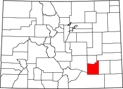
Location within Otero County and Colorado
Usa edcp location map.svg
Red pog.svg
Rocky Ford
Location within United States
Coordinates: 38°3′4″N103°43′17″W / 38.05111°N 103.72139°W / 38.05111; -103.72139
Country Flag of the United States.svg  United States
State Flag of Colorado.svg  Colorado
County Otero County [2]
City Rocky Ford [1]
Incorporated August 19, 1887 [3]
Government
  Type Statutory City [1]
Area
[4]
  Total1.69 sq mi (4.38 km2)
  Land1.68 sq mi (4.35 km2)
  Water0.01 sq mi (0.04 km2)
Elevation
[5]
4,180 ft (1,274 m)
Population
 (2020) [6]
  Total3,876
  Density2,300/sq mi (880/km2)
Time zone UTC-7 (Mountain (MST))
  Summer (DST) UTC-6 (MDT)
ZIP code [7]
81067
Area code 719
FIPS code 08-65190
GNIS feature [5] 0195481
Website cityofrockyford.colorado.gov

Rocky Ford is a statutory city located in Otero County, Colorado, United States. The population was 3,876 at the 2020 census. [6]

Contents

History

The community was named for a rocky ford across the Arkansas River near the original town site. [8]

Geography

According to the United States Census Bureau, the city has a total area of 1.7 square miles (4.4 km2), of which, 1.7 square miles (4.4 km2) is land and 0.58% is water.

Demographics

Historical population
CensusPop.Note
1880 47
1890 468895.7%
1900 2,018331.2%
1910 3,23060.1%
1920 3,74616.0%
1930 3,426−8.5%
1940 3,4932.0%
1950 4,08717.0%
1960 4,92920.6%
1970 4,859−1.4%
1980 4,804−1.1%
1990 4,162−13.4%
2000 4,2863.0%
2010 3,957−7.7%
2020 3,876−2.0%
U.S. Decennial Census

As of the census [9] of 2000, there were 4,286 people, 1,655 households, and 1,136 families residing in the city. The population density was 2,521.8 inhabitants per square mile (973.7/km2). There were 1,852 housing units at an average density of 1,089.7 per square mile (420.7/km2). The racial makeup of the city was 72.42% White, 0.40% African American, 1.47% Native American, 0.75% Asian, 0.12% Pacific Islander, 21.86% from other races, and 2.99% from two or more races. Hispanic or Latino people of any race were 57.14% of the population.

There were 1,655 households, out of which 33.0% had children under the age of 18 living with them, 48.1% were married couples living together, 15.5% had a female householder with no husband present, and 31.3% were non-families. 28.0% of all households were made up of individuals, and 12.7% had someone living alone who was 65 years of age or older. The average household size was 2.53 and the average family size was 3.07.

In the city, the population was spread out, with 28.2% under the age of 18, 8.7% from 18 to 24, 23.9% from 25 to 44, 21.6% from 45 to 64, and 17.6% who were 65 years of age or older. The median age was 37 years. For every 100 females, there were 95.9 males. For every 100 females age 18 and over, there were 91.2 males.

The median income for a household in the city was $23,359, and the median income for a family was $29,470. Males had a median income of $26,271 versus $17,485 for females. The per capita income for the city was $12,742. About 14.6% of families and 20.3% of the population were below the poverty line, including 28.2% of those under age 18 and 11.6% of those age 65 or over.

Economy

Rocky Ford is noted for its watermelon, cantaloupe and agriculture due to its soil content and fluctuation in temperatures providing great growing conditions. [10]

Transportation

Rocky Ford is part of Colorado's Bustang network. It is along the Lamar-Pueblo-Colorado Springs Outrider line. [11]

Notable people

Notable individuals who were born in or have lived in Rocky Ford include:

See also

Related Research Articles

<span class="mw-page-title-main">Alamosa, Colorado</span> City in Colorado, United States

Alamosa is a home rule municipality and the county seat of Alamosa County, Colorado, United States. The city population was 9,806 in the 2020 United States Census. The city is the commercial center of the San Luis Valley in south-central Colorado, and is the home of Adams State University.

<span class="mw-page-title-main">Otero County, Colorado</span> County in Colorado, United States

Otero County is a county located in the U.S. state of Colorado. As of the 2020 census, the population was 18,690. The county seat is La Junta. The county was named for Miguel Antonio Otero, one of the founders of the town of La Junta and a member of a prominent Hispanic family.

<span class="mw-page-title-main">Bent County, Colorado</span> County in Colorado, United States

Bent County is a county located in the U.S. state of Colorado. As of the 2020 census, the population was 5,650. The county seat and only incorporated municipality is Las Animas. The county is named in honor of frontier trader William Bent.

<span class="mw-page-title-main">Buena Vista, Colorado</span> Town in Colorado, United States

Buena Vista is a Statutory Town located in Chaffee County, Colorado, United States. The town population was 2,855 at the 2020 United States Census.

<span class="mw-page-title-main">Eagle, Colorado</span> Town in Colorado, United States

Eagle is the Statutory Town that is the county seat of Eagle County, Colorado, United States. The town population was 7,511 at the 2020 United States Census, a +15.41% increase since the 2010 United States Census. Eagle is the part of the Edwards, CO Micropolitan Statistical Area.

<span class="mw-page-title-main">Fountain, Colorado</span> City in Colorado, United States

The City of Fountain is a home rule municipality located in El Paso County, Colorado, United States. The city population was 29,802 at the 2020 United States Census, a +15.31% increase since the 2010 United States Census. Fountain is a part of the Colorado Springs, CO Metropolitan Statistical Area and the Front Range Urban Corridor.

<span class="mw-page-title-main">Penrose, Colorado</span> Unincorporated community in Fremont County, Colorado, United States

Penrose is a census-designated place (CDP) and post office located in and governed by Fremont County, Colorado, United States. The CDP is a part of the Cañon City, CO Micropolitan Statistical Area. The Penrose post office has the ZIP Code 81240. At the United States Census 2020, the population of the Penrose CDP was 3,685.

<span class="mw-page-title-main">Rifle, Colorado</span> City in Colorado, United States

Rifle is a home rule municipality in and the most populous community of Garfield County, Colorado, United States. The population was 10,437 at the 2020 census. Rifle is a regional center of the cattle ranching industry located along Interstate 70 and the Colorado River just east of the Roan Plateau, which dominates the western skyline of the town. The town was founded in 1882 by Abram Maxfield, and was incorporated in 1905 along Rifle Creek, near its mouth on the Colorado. The community takes its name from the creek.

<span class="mw-page-title-main">Aguilar, Colorado</span> Town in Colorado, United States

Aguilar is a Statutory Town located in Las Animas County, Colorado, United States. The town population was 456 at the 2020 United States Census. Cattleman and prominent pioneer José Ramón Aguilar founded the town in 1894.

<span class="mw-page-title-main">Sterling, Colorado</span> City in Colorado, United States

Sterling is a home rule municipality and the county seat and most populous municipality of Logan County, Colorado, United States. Sterling is the principal city of the Sterling, CO Micropolitan Statistical Area. The city population was 13,735 at the 2020 census.

<span class="mw-page-title-main">Cortez, Colorado</span> City in Colorado, United States

Cortez is a home rule municipality that is the county seat and the most populous municipality of Montezuma County, Colorado, United States. The city population was 8,766 at the 2020 United States Census.

<span class="mw-page-title-main">Dolores, Colorado</span> Town in Montezuma County, Colorado, United States

Dolores is a Statutory Town located in Montezuma County, Colorado, United States. The town population was 885 at the 2020 United States Census.

<span class="mw-page-title-main">Fowler, Colorado</span> Town in Colorado, United States

Fowler is a statutory town located in northwestern Otero County, Colorado, United States. The town population was 1,253 at the 2020 United States Census.

<span class="mw-page-title-main">Manzanola, Colorado</span> Town in Otero County, Colorado, United States

Manzanola is a Statutory Town in Otero County, Colorado, United States. The town population was 341 at the 2020 United States Census.

<span class="mw-page-title-main">Swink, Colorado</span> Town in Otero County, Colorado, United States

Swink is a Statutory Town in Otero County, Colorado, United States. The population was 604 at the 2020 census.

<span class="mw-page-title-main">Fairplay, Colorado</span> Town in Park County, Colorado, United States

Fairplay is a statutory town that is the county seat and the most populous municipality of Park County, Colorado, United States. The town population was 724 at the 2020 United States Census. Fairplay is located in South Park at an elevation of 9,953 feet (3,034 m). The town is the fifth-highest incorporated place in the State of Colorado. Fairplay is now a part of the Denver–Aurora–Lakewood, CO Metropolitan Statistical Area and the Front Range Urban Corridor.

<span class="mw-page-title-main">Moffat, Colorado</span> Town in Saguache County, Colorado, United States

The Town of Moffat is a statutory town in Saguache County, Colorado, United States. The town population was 108 at the 2020 United States Census.

<span class="mw-page-title-main">Frisco, Colorado</span> Town in Colorado, United States

Frisco is a home rule municipality located in Summit County, Colorado, United States. The town population was 2,913 at the 2020 United States Census. Frisco is a part of the Breckenridge, CO Micropolitan Statistical Area. It is a popular town among skiers from around the world. Four major ski resorts are located in close proximity to Frisco: Copper Mountain, Breckenridge, Keystone, and Arapahoe Basin.

<span class="mw-page-title-main">West Peoria, Illinois</span> City in Illinois, United States

West Peoria is a city in Peoria County, Illinois, United States. The population was 4,458 at the 2010 census. West Peoria is a suburb of Peoria and is part of the Peoria, Illinois Metropolitan Statistical Area.

Rocky Ford is a census-designated place (CDP) in Delaware and Cherokee counties, Oklahoma, United States. The population was 61 at the 2010 census.

References

  1. 1 2 3 "Active Colorado Municipalities". State of Colorado, Colorado Department of Local Affairs, Division of Local Government. Retrieved January 31, 2021.
  2. "Colorado Counties". State of Colorado, Colorado Department of Local Affairs, Division of Local Government. Retrieved January 31, 2021.
  3. "Colorado Municipal Incorporations". State of Colorado, Department of Personnel & Administration, Colorado State Archives. December 1, 2004. Retrieved September 2, 2007.
  4. "2019 U.S. Gazetteer Files". United States Census Bureau. Retrieved July 1, 2020.
  5. 1 2 "U.S. Board on Geographic Names: Domestic Names". United States Geological Survey . Retrieved January 31, 2021.
  6. 1 2 United States Census Bureau. "Rocky Ford city; Colorado" . Retrieved April 21, 2023.
  7. "ZIP Code Lookup" (JavaScript/HTML). United States Postal Service . Retrieved December 26, 2007.
  8. Dawson, John Frank. Place names in Colorado: why 700 communities were so named, 150 of Spanish or Indian origin. Denver, CO: The J. Frank Dawson Publishing Co. p. 43.
  9. "U.S. Census website". United States Census Bureau . Retrieved January 31, 2008.
  10. "Colorado more than mountains". Boca Raton News. November 6, 1983. p. 2. Retrieved May 7, 2015.
  11. "Bustang Schedule". RideBustang. CDOT.
  12. "Marvin Cordova Jr". BoxRec. Retrieved June 24, 2016.
  13. Roberts, Sam (July 22, 2015). "Paul Gebhard, Sex Researcher Who Worked With Kinsey, Dies at 98". The New York Times. Retrieved June 24, 2016.
  14. Colker, David (July 8, 2015). "Blaine Gibson dies at 97; prominent sculptor, animator at Disney". Los Angeles Times. Retrieved August 4, 2015.
  15. Weber, Bruce (July 11, 2015). "Blaine Gibson, Sculptor of Figures in Disney Parks, Dies at 97". New York Times . Retrieved August 4, 2015.
  16. "Oregon Secretary of State Agency History, page 15". Oregon Blue Book. Retrieved April 28, 2021.
  17. "Manuel Trinidad Pacheco". University of Arizona. Archived from the original on August 11, 2016. Retrieved June 24, 2016.
  18. "Our History". Rocky Ford Growers Association. Retrieved June 24, 2016.
  19. "Former Colorado Gov. Vanderhoof dies at 91". The Denver Post. AP. September 23, 2013. Retrieved June 24, 2016.