Timpas, Colorado

Last updated

Timpas, Colorado
Timpas, Colorado.JPG
Timpas and U.S. Route 350.
USA Colorado location map.svg
Red pog.svg
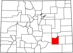
Location in Otero County and the state of Colorado
Usa edcp location map.svg
Red pog.svg
Timpas, Colorado (the United States)
Coordinates: 37°49′05″N103°46′25″W / 37.81806°N 103.77361°W / 37.81806; -103.77361
Country Flag of the United States (23px).png  United States
State Flag of Colorado.svg Colorado
County Otero County [1]
Elevation
[1]
4,430 ft (1,350 m)
Time zone UTC-7 (MST)
  Summer (DST) UTC-6 (MDT)
ZIP code [2]
81050 (La Junta)
Area code 719
GNIS feature ID 0195713

Timpas is an unincorporated community located in Otero County, Colorado, United States. The U.S. Post Office at La Junta (ZIP Code 81050) now serves Timpas postal addresses. [2]

Contents

A post office called Timpas was established in 1891, and remained in operation until 1970. [3] The community took its name from nearby Timpas Creek. [4]

Geography

Timpas is located at 37°49′05″N103°46′25″W / 37.81806°N 103.77361°W / 37.81806; -103.77361 (37.818056,-103.773594).

See also

Flag of Colorado.svg Coloradoportal

References

  1. 1 2 "US Board on Geographic Names". United States Geological Survey. October 25, 2007. Retrieved January 31, 2008.
  2. 1 2 "ZIP Code Lookup" (JavaScript/HTML). United States Postal Service. January 3, 2007. Retrieved January 3, 2007.
  3. "Post offices". Jim Forte Postal History. Retrieved July 11, 2016.
  4. Dawson, John Frank. Place names in Colorado: why 700 communities were so named, 150 of Spanish or Indian origin. Denver, CO: The J. Frank Dawson Publishing Co. p. 49.

Commons-logo.svg Media related to Timpas, Colorado at Wikimedia Commons