List of protected areas of Colorado

Last updated
The location of the State of Colorado in the United States of America. Colorado in United States.svg
The location of the State of Colorado in the United States of America .

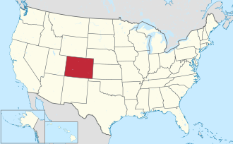
This is a list of protected areas in the U.S. State of Colorado.

Contents

Federal lands

The United States federal government owns 36.23% of Colorado's total land area.

National Park System

The National Park System includes 23 areas in Colorado. The National Park Service manages 18 of these 23 areas plus five National Wildernesses.

National Parks

The four National Parks within Colorado are:

National Monuments

The Great Kiva in Chimney Rock National Monument. Great Kiva at Chimney Rock Colorado.JPG
The Great Kiva in Chimney Rock National Monument.
Colorado National Monument. Colorado National Monument (29910584742).jpg
Colorado National Monument.
Steamboat Rock in Dinosaur National Monument. Dinosaur National Monument Steamboat Rock.jpg
Steamboat Rock in Dinosaur National Monument.

The nine National Monuments in Colorado are:

Two former National Monuments were elevated to National Park:

Two former National Monuments were abolished due to their remoteness:

National Historic Sites

Bent's Old Fort National Historic Site on the Santa Fe National Historic Trail. BentsFort.jpg
Bent's Old Fort National Historic Site on the Santa Fe National Historic Trail.

The three National Historic Sites within Colorado are:

National Recreation Areas

The Dillon Pinnacles in Curecanti National Recreation Area. Dillonpin.JPG
The Dillon Pinnacles in Curecanti National Recreation Area.

The two National Recreation Areas within Colorado are::

National Historic Trails

Spanish Peaks as seen from the Santa Fe National Historic Trail. Spanish Peaks at sunrise.JPG
Spanish Peaks as seen from the Santa Fe National Historic Trail.

The four National Historic Trails that pass through Colorado are:

National Scenic Trail

Grays Peak is the highest point on the Continental Divide National Scenic Trail and the Continental Divide in North America. Continental Divide Trail, Torreys to Grays.jpg
Grays Peak is the highest point on the Continental Divide National Scenic Trail and the Continental Divide in North America.

The National Scenic Trail that passes through Colorado is:

National Forests

An enlargeable map of Colorado showing the 11 National Forests in red and the 2 National Grasslands in light green National Forests in Colorado.png
An enlargeable map of Colorado showing the 11 National Forests in red and the 2 National Grasslands in light green
Mount Elbert in the San Isabel National Forest. Mount Elbert2.JPG
Mount Elbert in the San Isabel National Forest.

The United States Forest Service manages the 11 National Forests within Colorado.

National Grasslands

Picketwire Canyon in Comanche National Grassland. Picketwirecanyon.JPG
Picketwire Canyon in Comanche National Grassland.

The United States Forest Service manages the two National Grasslands within Colorado.

National Wildernesses

An enlargeable map of Colorado showing the 42 National Wildernesses in red Wilderness Areas in Colorado.png
An enlargeable map of Colorado showing the 42 National Wildernesses in red
East Rim Arch in the Black Ridge Canyons Wilderness. East Rim Arch - Rattlesnake Arches BRCW.jpg
East Rim Arch in the Black Ridge Canyons Wilderness.
Lake Isabelle in the Indian Peaks Wilderness. LakeIsabelle.jpg
Lake Isabelle in the Indian Peaks Wilderness.
Mystic Island Lake in the Holy Cross Wilderness. Mystic073107-64.jpg
Mystic Island Lake in the Holy Cross Wilderness.
The Lost Creek Wilderness. Lost Creek Wilderness in August 2013.jpg
The Lost Creek Wilderness.

There are 44 National Wildernesses within Colorado. The United States Forest Service manages 34, the National Park Service manages four, the Bureau of Land Management manages three, the United States Forest Service and the Bureau of Land Management jointly manage two, and the United States Forest Service and the National Park Service jointly manage one National Wilderness.

National Conservation Areas

The Dominguez-Escalante NCA. Dominguez-Escalante NCA (8931636408).jpg
The Dominguez–Escalante NCA.

The Bureau of Land Management manages the three National Conservation Areas within Colorado.

National Wildlife Refuges

The Two Ponds National Wildlife Refuge. Two Ponds NWR.JPG
The Two Ponds National Wildlife Refuge.

The United States Fish and Wildlife Service manages the eight National Wildlife Refuges within Colorado.

Federally designated areas

The following areas are designated by the National Park Service, but reside on a variety of federal, state, county, city, town, and private lands.

National Heritage Areas

The South Fork South Platte River in the South Park National Heritage Area. South Fork South Platte River.JPG
The South Fork South Platte River in the South Park National Heritage Area.

The three National Heritage Areas in Colorado are:

National Historic Landmarks

The Colorado Chautauqua Auditorium. Colorado Chautauqua Auditorium Boulder CO.jpg
The Colorado Chautauqua Auditorium.
The Cumbres and Toltec Scenic Railroad. Cumbres & Toltec Scenic Railroad excursion train headed by locomotive 484 in 2015.jpg
The Cumbres and Toltec Scenic Railroad.
The Tabor Grand Hotel in the Leadville Historic District. Tabor-Hotel.jpg
The Tabor Grand Hotel in the Leadville Historic District.

The 26 National Historic Landmarks in Colorado are:

National Natural Landmarks

The Garden of the Gods. Garden of the Gods.JPG
The Garden of the Gods.
Hanging Lake . Glenwood Canyon.jpg
Hanging Lake .

The 16 National Natural Landmarks in Colorado are:

National Recreation Trails

Grays Peak National Recreation Trail approaching the summit Grays and Torreys Peaks 2006-08-06.jpg
Grays Peak National Recreation Trail approaching the summit
Mountain goats along the Mount Evans National Recreation Trail. Mountain Goats on Mount Evans Colorado.JPG
Mountain goats along the Mount Evans National Recreation Trail.
Mule deer along one of the Rocky Mountain Arsenal National Recreation Trails. Mule-deer.jpg
Mule deer along one of the Rocky Mountain Arsenal National Recreation Trails.

The 28 federally designated National Recreation Trails in Colorado are:

National Register of Historic Places

The Royal Gorge Bridge. Royal Gorge Bridge (looking west).jpg
The Royal Gorge Bridge.

There are more than 1,500 Colorado sites on the National Register of Historic Places.

Wild and Scenic River

The Cache la Poudre Wild and Scenic River. Big South Trail 6-25 (32036041820).jpg
The Cache la Poudre Wild and Scenic River.

The Wild and Scenic River in Colorado is:

Areas of Critical Environmental Concern

The Blanca Wetlands ACEC. Blanca Wetlands Area of Critical Environmental Concern, Colorado (15476264730).jpg
The Blanca Wetlands ACEC.

The Bureau of Land Management has designated 88 Areas of Critical Environmental Concern in western Colorado.

State lands

Colorado State Parks

Eldorado Canyon State Park. Eldorado Canyon.JPG
Eldorado Canyon State Park.
Fishers Peak State Park. Fishers Peak State Park.JPG
Fishers Peak State Park.
A yurt in Mancos State Park. Yurt at Mancos State Park in Colorado.JPG
A yurt in Mancos State Park.
Roxborough State Park. Fountain Valley Trail (5974714678).jpg
Roxborough State Park.
State Forest State Park. North Michigan Creek Reservoir.JPG
State Forest State Park.

Colorado Parks and Wildlife manages the 43 Colorado State Parks.

Colorado Wildlife Areas

DeWeese Reservoir State Wildlife Area. DeWeese Reservoir.JPG
DeWeese Reservoir State Wildlife Area.

Colorado Parks and Wildlife manages the 307 Colorado State Wildlife Areas.

State designated areas

Colorado Natural Areas

The Arikaree River Natural Area. Arikaree River valley 2016-07-12 1283.jpg
The Arikaree River Natural Area.
Dinosaur tracks in the Dakota Hogback Natural Area. Dino Tracks 2017-09-30 1631.jpg
Dinosaur tracks in the Dakota Hogback Natural Area.
The Garden Park Fossil Locality. Marsh Quarry.JPG
The Garden Park Fossil Locality.
The Lake San Cristobal Natural Area. Lake San Cristobal CO.jpg
The Lake San Cristobal Natural Area.
The Mount Goliath Natural Area. Rocky Mountains Bristlecone Pine, Mount Goliath, Colorado (2).jpg
The Mount Goliath Natural Area.
The Rabbit Valley Natural Area. RabbitValley1.jpg
The Rabbit Valley Natural Area.
The Redcloud Peak Natural Area. Sanjuan14ers-8.jpg
The Redcloud Peak Natural Area.
The Roxborough Natural Area. Roxborough.jpg
The Roxborough Natural Area.
The Slumgullion Earthflow Natural Area. Slumgullion Earthflow.jpg
The Slumgullion Earthflow Natural Area.
The Staunton Natural Area. Staunton State Park.JPG
The Staunton Natural Area.
Exposed Cretaceous-Paleogene boundary at the Trinidad K-T Boundary Natural Area. Trinlake2.JPG
Exposed Cretaceous–Paleogene boundary at the Trinidad K-T Boundary Natural Area.
The Wheeler Geologic Natural Area. Wheeler Geologic Area (36885224576).jpg
The Wheeler Geologic Natural Area.

The Colorado Department of Natural Resources has designated 95 Colorado Natural Areas. [1]

Regional trails

A cyclist on the Kokopelli Trail in McInnis Canyons National Conservation Area. McInnis Canyons National Conservation Area (9323589206).jpg
A cyclist on the Kokopelli Trail in McInnis Canyons National Conservation Area.

The following transcontinental hiking trail was established by the American Discovery Trail Society.

The following hiking trail across the Southern Rocky Mountains is maintained by the Colorado Trail Foundation.

The following three single-track mountain bike trails are maintained by the Colorado Plateau Mountain Bike Trail Association and the Bureau of Land Management.

Bicycle routes

Hoosier Pass on the TransAmerica Trail Bicycle Route. Mules in the valley threaded by Hoosier Pass, high in Colorado's Rocky Mountains straddling Park and Summit counties. This pass is the highest point on the TransAmerica Trail, a transcontinental LCCN2015633685.tif
Hoosier Pass on the TransAmerica Trail Bicycle Route.

The following four bicycle touring routes through Colorado are regularly scouted by the Adventure Cycling Association.

See also

Notes

  1. 1 2 3 Jointly managed by the United States Department of the Interior, Bureau of Land Management and the United States Department of Agriculture, United States Forest Service.
  2. 1 2 3 Managed by the United States Department of the Interior, Bureau of Land Management.
  3. 1 2 3 4 5 6 7 8 9 10 11 12 13 14 15 16 17 18 19 20 21 22 23 24 25 26 27 28 29 30 31 32 33 34 35 36 37 38 39 40 41 42 43 44 45 46 47 48 49 50 51 52 53 54 55 56 57 58 Managed by the United States Department of Agriculture, United States Forest Service.
  4. Dinosaur National Monument extends into the State of Utah.
  5. Hovenweep National Monument extends into the State of Utah.
  6. Yucca House National Monument remains undeveloped.
  7. The California National Historic Trail traverses ten U.S. states: Missouri, Kansas, Nebraska, Colorado, Wyoming, Idaho, Utah, Nevada, Oregon, and California.
  8. The Old Spanish National Historic Trail traverses six U.S. states: New Mexico, Colorado, Utah, Arizona, Nevada, and California.
  9. The Pony Express National Historic Trail traverses eight U.S. states: Missouri, Kansas, Nebraska, Colorado, Wyoming, Utah, Nevada, and California.
  10. The Santa Fe National Historic Trail traverses five U.S. states: Missouri, Kansas, Colorado, Oklahoma, and New Mexico.
  11. The Continental Divide National Scenic Trail traverses five U.S. states: Montana, Idaho, Wyoming, Colorado, and New Mexico.
  12. 1 2 3 4 5 6 7 8 Managed by the United States Department of the Interior, National Park Service.
  13. Jointly managed by the United States Department of the Interior, National Park Service and the United States Department of Agriculture, National Forest Service.
  14. Managed by the United States Air Force.
  15. 1 2 Managed by Colorado Parks and Wildlife.
  16. Managed by the Jefferson County Open Space Program.
  17. Managed by the City of Westminster, Colorado.
  18. 1 2 Managed by Colorado State Parks.
  19. Managed by Lake County, Colorado.
  20. Managed by the Poudre River Trail Corridor, Inc.
  21. 1 2 Managed by the United States Department of the Interior, United States Fish and Wildlife Service.
  22. Managed by the Colorado Springs Parks and Recreation Department.

Related Research Articles

<span class="mw-page-title-main">Black Canyon of the Gunnison National Park</span> National park in Colorado, United States

Black Canyon of the Gunnison National Park is an American national park located in western Colorado and managed by the National Park Service. There are two primary entrances to the park: the south rim entrance is located 15 miles (24 km) east of Montrose, while the north rim entrance is 11 miles (18 km) south of Crawford and is closed in the winter. The park contains 12 miles (19 km) of the 48-mile-long (77 km) Black Canyon of the Gunnison River. The national park itself contains the deepest and most dramatic section of the canyon, but the canyon continues upstream into Curecanti National Recreation Area and downstream into Gunnison Gorge National Conservation Area. The canyon's name owes itself to the fact that parts of the gorge only receive 33 minutes of sunlight a day, according to Images of America: The Black Canyon of the Gunnison. In the book, author Duane Vandenbusche states, "Several canyons of the American West are longer and some are deeper, but none combines the depth, sheerness, narrowness, darkness, and dread of the Black Canyon."

<span class="mw-page-title-main">Colorado Plateau</span> Plateau in southwestern United States

The Colorado Plateau, also known as the Colorado Plateau Province, is a physiographic and desert region of the Intermontane Plateaus, roughly centered on the Four Corners region of the southwestern United States. This province covers an area of 336,700 km2 (130,000 mi2) within western Colorado, northwestern New Mexico, southern and eastern Utah, northern Arizona, and a tiny fraction in the extreme southeast of Nevada. About 90% of the area is drained by the Colorado River and its main tributaries: the Green, San Juan, and Little Colorado. Most of the remainder of the plateau is drained by the Rio Grande and its tributaries.

<span class="mw-page-title-main">American Discovery Trail</span> Long-distance hiking trail across the United States

The American Discovery Trail is a system of recreational trails and roads that collectively form a coast-to-coast hiking and biking trail across the mid-tier of the United States. Horses can also be ridden on most of this trail. The coastal trailheads are the Delmarva Peninsula on the Atlantic Ocean and the northern California coast on the Pacific Ocean. The trail has northern and southern alternates for part of its distance, passing through Chicago and St. Louis respectively. The total length of the trail, including both the north and south routes, is 6,800 miles (10,900 km). The northern route covers 4,834 miles (7,780 km) with the southern route covering 5,057 miles (8,138 km). It is the only non-motorized coast-to-coast trail.

<span class="mw-page-title-main">Curecanti National Recreation Area</span> National Park Service in Colorado, US

Curecanti National Recreation Area is a National Park Service unit located on the Gunnison River in western Colorado. Established in 1965, Curecanti National Recreation Area is responsible for developing and managing recreational facilities on three reservoirs, Blue Mesa Reservoir, Morrow Point Reservoir and Crystal Reservoir, constructed on the upper Gunnison River in the 1960s by the U.S. Bureau of Reclamation to better utilize the vital waters of the Colorado River and its major tributaries. A popular destination for boating and fishing, Curecanti offers visitors two marinas, traditional and group campgrounds, hiking trails, boat launches, and boat-in campsites. The state's premiere lake trout and Kokanee salmon fisheries, Curecanti is a popular destination for boating and fishing, and is also a popular area for ice-fishing in the winter months.

<span class="mw-page-title-main">White River National Forest</span> National forest in northwest Colorado

White River National Forest is a National Forest in northwest Colorado. It is named after the White River that passes through its northern section. It is the most visited National Forest in the United States, primarily from users of the twelve ski areas within its boundaries.

<span class="mw-page-title-main">Blue Mesa Reservoir</span> Lake on the Gunnison River in Colorado, United States

Blue Mesa Reservoir is an artificial reservoir located on the upper reaches of the Gunnison River in Gunnison County, Colorado. The largest lake located entirely within the state, Blue Mesa Reservoir was created by the construction of Blue Mesa Dam, a 390 feet (120 m) tall earthen fill dam constructed on the Gunnison by the U.S. Bureau of Reclamation in 1966 for the generation of hydroelectric power. Managed as part of the Curecanti National Recreation Area, a unit of the National Park Service, Blue Mesa Reservoir is the largest lake trout and Kokanee salmon fishery in Colorado.

<span class="mw-page-title-main">Geography of Colorado Springs, Colorado</span>

Colorado Springs geography describes geographical topics regarding the city of Colorado Springs, Colorado in El Paso County, Colorado. With 194.87 sq mi (504.7 km2) of land, it is the state's largest-sized city. Denver is the most populated city.

<span class="mw-page-title-main">Index of Colorado-related articles</span>

This is an alphabetical list of articles related to the U.S. State of Colorado.

<span class="mw-page-title-main">Index of Utah-related articles</span>

The following is an alphabetical list of articles related to the U.S. state of Utah.

<span class="mw-page-title-main">Index of Montana-related articles</span>

The following is an alphabetical list of articles related to the U.S. state of Montana.

The Monarch Wilderness is a federally designated wilderness area located 70 miles east of Fresno, California, in the Sierra Nevada mountain range. It encompasses 44,896 acres (181.69 km2) within both the Sequoia National Forest and the Sierra National Forest and is managed by the United States Forest Service. Elevations range from 950 feet (290 m) to 11,081 ft (3,377 m).

<span class="mw-page-title-main">Sugarite Canyon State Park</span> State park in New Mexico, United States

Sugarite Canyon State Park is a state park of New Mexico, United States, featuring a historic early-20th century coal-mining camp and natural scenery at the border of the Rocky Mountains and the Great Plains. The park is located on the Colorado–New Mexico state line 6 miles (9.7 km) northeast of Raton, New Mexico.

<span class="mw-page-title-main">Santa Rosa Wilderness</span> Protected wilderness area in California, United States

The Santa Rosa Wilderness is a 72,259-acre (292.42 km2) wilderness area in Southern California, in the Santa Rosa Mountains of Riverside and San Diego counties, California. It is in the Colorado Desert section of the Sonoran Desert, above the Coachella Valley and Lower Colorado River Valley regions in a Peninsular Range, between La Quinta to the north and Anza Borrego Desert State Park to the south. The United States Congress established the wilderness in 1984 with the passage of the California Wilderness Act, managed by both the US Forest Service and the Bureau of Land Management. In 2009, the Omnibus Public Land Management Act was signed into law which added more than 2,000 acres (8.1 km2). Most of the Santa Rosa Wilderness is within the Santa Rosa and San Jacinto Mountains National Monument.

<span class="mw-page-title-main">John D. Dingell Jr. Conservation, Management, and Recreation Act</span> United States federal omnibus lands act

The John D. Dingell Jr. Conservation, Management, and Recreation Act of 2019 is an omnibus lands act that protected public lands and modified management provisions. The bill designated more than 1,300,000 acres (5,300 km2) of wilderness area, expanded several national parks and other areas of the National Park System, and established four new national monuments while redesignating others. Other provisions included making the Land and Water Conservation Fund permanent, protecting a number of rivers and historic sites, and withdrawing land near Yellowstone National Park and North Cascades National Park from mining.

<span class="mw-page-title-main">Protected areas of North Carolina</span> North Carolina protected areas

The protected areas of North Carolina cover roughly 3.8 million acres, making up 11% of the total land in the state. 86.5% of this protected land is publicly owned and is managed by different federal and state level authorities and receive varying levels of protection. Some areas are managed as wilderness while others are operated with acceptable commercial exploitation. The remainder of the land is privately owned, but willingly entered into conservation easement management agreements, or are owned by various nonprofit conservation groups such as the National Audubon Society and The Nature Conservancy. North Carolina contains 1 National Park, and various other federally owned protected land including 2 National Seashores, 5 National Forests, 12 Wildlife Refuges, and the southern half of the Blue Ridge Parkway. North Carolina has an extensive state park system of 42 open units, 35 of which are state parks, 4 that are recreation areas, and 3 staffed state natural areas, along with other designated units managed by the North Carolina Department of Natural and Cultural Resources.

References

  1. "Colorado Natural Areas Program, 2018-2020 review, triennal report to Governor Polis" (PDF). Colorado Parks & Wildlife. State of Colorado. n.d. Archived (PDF) from the original on 2022-03-20. Retrieved 2022-07-25.

38°59′50″N105°32′52″W / 38.9972°N 105.5478°W / 38.9972; -105.5478 (State of Colorado)