This is a list of National Natural Landmarks in the U.S. State of Colorado . 
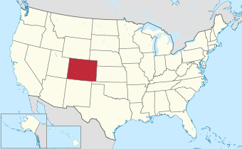
There are 16 National Natural Landmarks in Colorado, one of which extends into Wyoming. They cover areas of geological, biological and historical importance, and include lakes, mountains, rock formations and numerous fossil sites. The landmarks are located in 14 of the state's 64 counties. Four counties each contain all or part of two NNLs, while two landmarks are split between two counties. The first two designations, Slumgullion Earthflow and Summit Lake, were made in 1965, while the most recent designation, Sulphur Cave and Spring, was made in 2021. [1] [2] [3] Natural Landmarks in Colorado range from 60 to 380,000 acres (24.3 to 153,780.5 ha; 0.1 to 593.8 sq mi) in size. Owners include private individuals and several municipal, state and federal agencies. [4]
The National Natural Landmarks Program is administered by the National Park Service, a branch of the Department of the Interior. The National Park Service determines which properties meet NNL criteria and, after notifying the owners, makes nomination recommendations. The Secretary of the Interior reviews nominations and, based on a set of predetermined criteria, makes a decision on NNL designation or a determination of eligibility for designation. Both public and privately owned properties can be designated as NNLs. Owners may object to the nomination of the property as a NNL. [5] This designation provides indirect, partial protection of the historic integrity of the properties via tax incentives, grants, monitoring of threats, and other means. [6]
# | Name | Image | Year | Location | County | Ownership | Description |
---|---|---|---|---|---|---|---|
1 | Big Spring Creek | 2012 | 37°46′00″N105°37′30″W / 37.7666667°N 105.6250000°W | Saguache | Federal | Unique spring-fed creek fed by an unconfined aquifer, creating a rare animal- and plant-supporting wetlands in a generally arid area. Part of Great Sand Dunes National Park and Preserve. [7] | |
2 | Garden of the Gods | 1971 | 38°52′04″N104°53′28″W / 38.8677690°N 104.8910877°W | El Paso | Municipal | The site showcases the lithologic character of sedimentary rocks, as well as providing a habitat for North American honey ants and excellent viewing opportunities for several bird species. [8] | |
3 | Garden Park Fossil Area | 1973 | 38°32′06″N105°13′18″W / 38.5349959°N 105.2216545°W | Fremont | Federal | Internationally recognized paleontological site renowned for finds of dinosaur, fish, crocodile, turtle and mammal fossils. Located on Bureau of Land Management land. [9] | |
4 | Hanging Lake | 2011 | 39°36′05″N107°11′30″W / 39.6013883°N 107.1917138°W | Garfield | Federal | Travertine deposition-formed lake with substantial hanging garden plant life and minimal human alteration, unique in the region. A part of White River National Forest. [10] | |
5 | Indian Springs Trace Fossil Site | 1979 | 38°22′03″N105°29′07″W / 38.3674977°N 105.4852759°W | Fremont | Private | Best North American location for animal trace fossils from the Ordovician period. [11] | |
6 | Lost Creek Scenic Area | 1966 | 39°16′07″N105°28′05″W / 39.268611°N 105.468056°W | Park, Jefferson | Federal | 
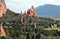
Located in Pike National Forest, with extensive rock formations, including gorges, ridges and spires, and stream channels that meander between above- and under-ground. | |
7 | Morrison-Golden Fossil Areas | 1973 | 39°40′52″N105°11′33″W / 39.68100°N 105.19238°W | Jefferson | County, private | 
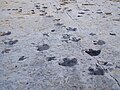
Site of major paleontological importance, unique for fossil footprints of reptiles, birds, and mammals. The site was expanded in 2011 to include the 19-acre (7.69 ha; 0.03 sq mi) Parfet Prehistoric Preserve in the city of Golden. [12] | |
8 | Raton Mesa | 1967 | 37°05′52″N104°27′46″W / 37.0978686°N 104.4627319°W | Las Animas | State, private | 
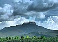
Protected by a thick lava cap, Raton Mesa has resisted the extensive erosion and weathering that has affected surrounding areas, providing an extreme contrast in geography. | |
9 | Roxborough State Park | 1980 | 39°25′45″N105°04′06″E / 39.42907°N 105.06841°E | Douglas | State | Site showcases typical Colorado Front Range sedimentary strata, as well as erosion of Fountain Formation sandstone in unusual patterns, extensive fossil remains and unusual plant populations. | |
10 | Russell Lakes | 1975 | 37°56′41″N106°07′12″W / 37.9448092°N 106.1199637°W | Saguache | Federal, private | 
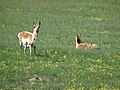
Colorado's largest remaining bulrush marsh, now rare in the southern Rocky Mountains. Provides habitat for extensive flora and fauna, especially waterfowl. | |
11 | Sand Creek | 1984 | 40°59′45″N105°46′05″W / 40.9957404°N 105.7681064°W | Larimer | Federal, state, private | Shared with Wyoming, the site is one of North America's most impressive occurrences of cross-bedded sandstone and "topple blocks". Also a site of paleontological and biological significance. | |
12 | Slumgullion Earthflow | 1965 | 37°59′55″N107°14′42″W / 37.9986086°N 107.2450542°W | Hinsdale | Federal, private | A major example of the geologic process of mass wasting, a large flow of volcanic rock traveled from mountainside to valley to form Lake San Cristobal. The same process is occurring again, slowly covering the existing flow. Located on Bureau of Land Management land. | |
13 | Spanish Peaks | 1976 | 37°22′32″N104°59′37″W / 37.3756661°N 104.9936861°W | Huerfano, Las Animas | Federal, private | Located in San Isabel National Forest, the site is an exceptional illustration of over 500 igneous dikes, many exposed, formed when molten igneous rock is forced into a fault before hardening. | |
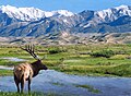
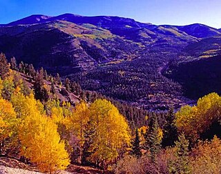
14 | Sulphur Cave and Spring | 2021 | 40°29′01″N106°50′24″W / 40.4836973°N 106.8401306°W | Routt | Municipal | Located in the Howelsen Hill Ski Area of Steamboat Springs, the site is a superb example of bacterially-mediated sulfuric acid speleogenesis. The cave contains many uncommon cave features, such as biovermiculations and snottites. | |
15 | Summit Lake | 1965 | 39°35′54″N105°38′40″W / 39.5983532°N 105.6443243°W | Clear Creek | Municipal | At almost 13,000 feet (4,000 m), the site contains an excellent example of alpine tundra in the contiguous US. Some of the plants that survive in this microclimate are usually found only in the Arctic Circle. | |
16 | West Bijou Site | 2016 | 39°40′52″N104°44′09″W / 39.68100°N 104.73588°W | Arapahoe | Private | Part of the Plains Conservation Center, the site contains fossil and mineral evidence detailing the Cretaceous–Paleogene boundary, the Earth's most recent mass extinction event. [2] | |
The National Natural Landmarks (NNL) Program recognizes and encourages the conservation of outstanding examples of the natural history of the United States. It is the only national natural areas program that identifies and recognizes the best examples of biological and geological features in both public and private ownership. The program was established on May 18, 1962, by United States Secretary of the Interior Stewart Udall.
Slumgullion Pass is a mountain pass in southwestern Colorado traversed by State Highway 149 east of Lake City. The north side has the steepest grade of any continuously paved road in Colorado (9%), but the pass does not close often in winter because snowplows clear the route regularly during this season. It has a few switchbacks and tight spots, but other than that, most travelers will find it an easy, scenic route.
The North Central Colorado Urban Area comprises the four contiguous metropolitan statistical areas in the north central region of the State of Colorado: the Denver–Aurora Metropolitan Statistical Area, the Boulder Metropolitan Statistical Area, the Fort Collins-Loveland Metropolitan Statistical Area, and the Greeley Metropolitan Statistical Area. With the exception of southeastern Elbert County, southeastern Park County, and tiny portions of southern Douglas County, the entire North Central Colorado Urban Area is drained by the South Platte River and its tributaries. The North Central Colorado Urban Area is the central, and the most populous, of the three primary subregions of the Front Range Urban Corridor.
The South Central Colorado Urban Area comprises the Colorado Springs Metropolitan Statistical Area, the Pueblo Metropolitan Statistical Area, and the Cañon City Micropolitan Statistical Area in the central and south central region of the State of Colorado. With the exception of northern Teller County and small portions of northern El Paso County, the entire South Central Colorado Urban Area is drained by the Arkansas River and its tributaries. The South Central Colorado Urban Area is the southernmost of the three primary subregions of the Front Range Urban Corridor.
Lake Agassiz Peatlands Natural Area is a 25,411-acre (10,283 ha) National Natural Landmark located in Koochiching County, Minnesota. Designated in November 1965 under the Historic Sites Act, its ownership and oversight are provided by the National Park Service of the United States. This designation from the United States Secretary of the Interior, gives it recognition as an outstanding example of the nation's natural history. The designation describes it as
An example of the extensive peatlands occupying the bed of ancient glacial Lake Agassiz, illustrating the process of peat accumulation over about 11,000 years. The area contains Myrtle Lake Bog, which developed contrary to the usual successional process of lake filling, and is an excellent example of both raised and string bogs.
The Cedar Creek Ecosystem Science Reserve is an ecological research site located primarily in East Bethel, Minnesota in the counties of Anoka and Isanti on the northern edge of the Minneapolis-Saint Paul metropolitan area. Encompassing 5,400 acres (22 km2) of native upland forests and prairie and lowland swamps and meadows, the site contains over 900 plots of long-term experimental research which evaluate plant competition and biodiversity. The herbivory research division examines animal and plant relationships. Led by prominent American ecologist G. David Tilman, the University schedules more than 130 faculty, post-doctoral researchers, graduate students, staff, and undergraduate researcher interns to the site as of 2006.
Lake San Cristobal is a lake in the U.S. state of Colorado. Located in the San Juan Mountains at an elevation of 9,003 feet (2,744 m), the freshwater lake is 2.1 miles (3.4 km) long, up to 89 feet (27 m) deep, has a surface area of 0.52 square miles (1.3 km2), and holds about 11,000 acre-feet (14,000,000 m3) of water. The town of Lake City, a few miles to the north, is named after Lake San Cristobal. The name San Cristóbal means Saint Christopher in the Spanish language. Many old silver mines are near the lake and it is very clean and well kept, and stocked with Rainbow Trout.
The Slumgullion Earthflow in the San Juan Mountains in Hinsdale County, Colorado has been a National Natural Landmark since 1983. It is also a Colorado Natural Area and an Area of Critical Environmental Concern.