WikiMili
List of National Natural Landmarks in Oregon
Last updated
November 07, 2025
Map all coordinates using
OpenStreetMap
Download coordinates as
KML
There are 11
National Natural Landmarks
in the
U.S. state
of
Oregon
.
[
1
]
Crown Point
Fort Rock State Monument
Horse Ridge Natural Area
John Day Fossil Beds
The Island
Mount Howard-East Peak
Newberry Crater
Willamette Floodplain
Zumwalt Prairie
class=notpageimage|
Oregon National Natural Landmarks (clickable map)
Name
Image
Date
Location
County
Ownership
Description
Crown Point
1971
45°32′22″N
122°14′39″W
/
45.5395°N 122.24422°W
/
45.5395; -122.24422
(
Crown Point
)
Multnomah
state park
Promontory
in Columbia Gorge
Fort Rock State Monument
1976
43°22′19″N
121°04′26″W
/
43.372°N 121.074°W
/
43.372; -121.074
(
Fort Rock
)
Lake
state park
Volcanic
tuff ring
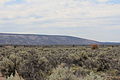
Horse Ridge Natural Area
1967
43°55′26″N
121°02′20″W
/
43.924°N 121.039°W
/
43.924; -121.039
(
Horse Ridge
)
[
2
]
Deschutes
federal
Western juniper woodland on
Bureau of Land Management
property.
[
2
]
John Day Fossil Beds
1966
44°33′21″N
119°38′43″W
/
44.555833°N 119.645278°W
/
44.555833; -119.645278
(
John Day Fossil Beds
)
Grant
federal
Contains a remarkable sequence of very diverse fossils.
The Island
2011
44°33′31″N
121°16′38″W
/
44.558489°N 121.277143°W
/
44.558489; -121.277143
(
The Island
)
Jefferson
federal
Native juniper savanna on an isolated plateau at the confluence of the Deschutes and Crooked Rivers. Part of
Ochoco National Forest
.
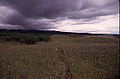
Lawrence Memorial Grassland Preserve
1984
44°57′03″N
120°47′56″W
/
44.950889°N 120.7988834°W
/
44.950889; -120.7988834
(
Lawrence Memorial Grassland Preserve
)
Oregon
private
An excellent illustration of "biscuit and scabland" topography.
[
3
]
Newberry Crater
1976
43°41′21″N
121°15′18″W
/
43.689194°N 121.254889°W
/
43.689194; -121.254889
(
Newberry Volcano
)
Deschutes
federal
Atypical shield volcano in
Deschutes National Forest
.
Mount Howard-East Peak
2016
45°15′40″N
117°10′44″W
/
45.260987°N 117.178778°W
/
45.260987; -117.178778
(
Mount Howard-East Peak
)
Wallowa
federal
Contains botanically diverse montane grassland habitats and populations of endemic and rare plant species.
Round Top Butte
2011
42°31′40″N
122°41′02″W
/
42.5277551°N 122.68381°W
/
42.5277551; -122.68381
(
Newberry Volcano
)
[
4
]
Jackson
federal
Exceptional native bunchgrass habitat. Located on
Bureau of Land Management
land.
[
5
]
[
6
]
Willamette Floodplain
1987
44°21′50″N
123°13′48″W
/
44.364°N 123.23°W
/
44.364; -123.23
(
Willamette Floodplain
)
Benton
,
Lane
,
Linn
,
Marion
,
Polk
federal
A bottomland interior valley grassland floodplain. Part of
William L. Finley National Wildlife Refuge
.
Zumwalt Prairie
2013
45°32′N
117°05′W
/
45.54°N 117.09°W
/
45.54; -117.09
(
Zumwalt Prairie
)
Wallowa
private
Largest contiguous remaining tract of bunchgrass prairie in the nation.
See also
List of National Historic Landmarks in Oregon
References
↑
Hale, Jamie (August 10, 2016).
"Oregon Travel News: Oregon's 11 National Natural Landmarks"
.
The Oregonian
. Oregonlive / The Oregonian
. Retrieved
August 10,
2017
.
1
2
"Horse Ridge Natural Area"
.
Geographic Names Information System
.
United States Geological Survey
,
United States Department of the Interior
. Retrieved
April 5,
2009
.
↑
"Lawrence Memorial Grassland Preserve"
.
Conservation Gateway
. The Nature Conservancy
. Retrieved
August 10,
2017
.
↑
"Round Top Butte RNA"
.
Pacific Northwest Interagency Natural Areas Network
. Oregon State University, Forestry Sciences Laboratory
. Retrieved
August 31,
2017
.
↑
https://www.fs.fed.us/pnw/pubs/pnw_gtr895.pdf%5B%5D
↑
"Oregon Natural Areas Plan 2015"
(PDF)
. Archived from
the original
(PDF)
on February 21, 2016.
v
t
e
National Natural Landmarks
in the United States
Alabama
Alaska
Arizona
Arkansas
California
Colorado
Connecticut
Delaware
Florida
Georgia
Hawaii
Idaho
Illinois
Indiana
Iowa
Kansas
Kentucky
Louisiana
Maine
Maryland
Massachusetts
Michigan
Minnesota
Mississippi
Missouri
Montana
Nebraska
Nevada
New Hampshire
New Jersey
New Mexico
New York
North Carolina
North Dakota
Ohio
Oklahoma
Oregon
Pennsylvania
Rhode Island
South Carolina
South Dakota
Tennessee
Texas
Utah
Vermont
Virginia
Washington
West Virginia
Wisconsin
Wyoming
American Samoa
Guam
Puerto Rico
Virgin Islands
This page is based on this
Wikipedia article
Text is available under the
CC BY-SA 4.0
license; additional terms may apply.
Images, videos and audio are available under their respective licenses.