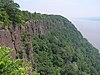
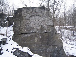
Hook Mountain, part of the "Hook Mountain and Nyack Beach State Park National Natural Landmark", designated in 1980 for its portion of the Palisades Sill.
New York's NNLs cover unique landforms carved by glacial meltwater, a rare meromictic lake, several exposed fossil sites, and the largest open fault system in the United States. The state's first NNLs, Bergen-Byron Swamp and Mianus River Gorge, were designated in 1964 and are the oldest NNLs in the nation; New York's newest NNL is the Albany Pine Bush, designated in 2014. Owners include private individuals, non-governmental conservation organizations, and several municipal, state and federal agencies.[1] Designation as a NNL does not guarantee that a property is open to the public, and some are located on private property with restricted access.[2]
The National Natural Landmarks Program is administered by the National Park Service, a branch of the Department of the Interior. NNLs are intended to showcase important biological and/or geological features, and represent illustrative or well-preserved examples of such sites within a given biological or physiographic province. Properties considered for NNL status are nominated by the National Park Service, and are accepted or rejected by the Secretary of the Interior after a review process.[2]
The designation provides indirect, partial protection of the historic and biological integrity of the properties via tax incentives, grants, monitoring of threats, and other means. However, designation do never directly prohibit destruction or alteration of the property, and the designation may be revoked at any time by the National Park Service if the NNL is considered to have been significantly altered or damaged. Properties may also be de-designated by request of the property owner.[2]
A 310-acre (1.3km2)Nature Conservancy preserve including a pond and surrounding swamp and woodland. It is recognized for its great laurel tree population.
A 398-acre (1.61km2)Nature Conservancy preserve, containing 80 acres (0.32km2) of old growth forest. It is known for its wildlife and its gorges which highlight the Onondaga Escarpment.
A 1,350-acre (5.5km2) wetland marsh located at the Eastern end of Lake Ontario. It is a popular fishing and trapping area as well as a migratory bird layover.
The largest open fault system in the United States results in ice caves which keeps ice year round and creates a cooler microclimate for more northern plants. Now part of Sam's Point Preserve.
A 2,500-acre (10km2) county park known for its birdwatching and its unusual glacial geology, including kettle holes, eskers, kames, and a floating sphagnum mosspeat bog known as the Devils Bathtub.
A 7,000-acre (28km2) National Wildlife Refuge containing one of the best examples of undisturbed swamp woodlands in New York or New England. It is a major stop for migratory birds.
An igneousintrusion in the Erie Canal with the Little Falls at one end. It became an island when locks were built so boats could avoid the 40ft (12m) falls. It is known for its extremely large 40–50 feet (12–15m)glacial potholes created by retreating glaciers as well as being popular with local rock climbers.
An 83-acre (340,000m2) glacial kettle lake which filled with melt water and rain. Over time, sphagnum moss has grown over the open water, turning it into an acidic bog. It is managed by The Nature Conservancy.
This private park preserves an area of ancient stromatolites in a fossilized ancient Cambrian reef. Stromatolites "were first recognized, discovered, and interpreted in North America" here in 1922. The park, which is now closed, was a childhood inspiration for Stephen Jay Gould.
A 75-acre (300,000m2)glacialkettle pond and surrounding 507-acre (2.05km2) nature preserve managed by The Nature Conservancy. It is the source of Wappinger Creek, a tributary of the Hudson River that drains much of Dutchess County. It is known for its calcareousbogs, distinct from the acidic bogs found elsewhere in the Northeast.
A sphagnumbog managed by the Bergen Swamp Preservation Society.
Former National Natural Landmark
According to a notice in the Federal Register in July 2006, Gardiner's Island in Suffolk County was removed by the Department of the Interior from National Natural Landmark status in response to owner requests.[6] It was originally designated in April 1967. Its description formerly read: "The island is a breeding ground for osprey and is an important habitat of other fauna, particularly waterfowl and shore birds."[7]
The National Natural Landmarks (NNL) Program recognizes and encourages the conservation of outstanding examples of the natural history of the United States. It is the only national natural areas program that identifies and recognizes the best examples of biological and geological features in both public and private ownership. The program was established on May 18, 1962, by United States Secretary of the Interior Stewart Udall.
List of the National Register of Historic Places listings in Rockland County, New York
The Chazy Reef Formation is a mid-Ordovician limestone deposit in northeastern North America.
The Mianus River Gorge is a 935-acre (3.78 km2) nature preserve in Bedford, New York jointly owned by The Nature Conservancy and Mianus River Gorge, Inc.. The first 60 acres (0.24 km2) were purchased by the Preserve, with help from the Conservancy, their first land preservation deal. It has grown over the years and is still managed by Mianus River Gorge, Inc. In March 1964, it was designated a National Natural Landmark for its old growth climax hemlock forest and the gorge of the Mianus River.
Valcour Island is a 968-acre (3.92 km2) island in Lake Champlain in Clinton County, New York, United States. The island is mostly in the Town of Peru and partly in the Town of Plattsburgh, southeast of the City of Plattsburgh. It is within the boundaries of the Adirondack Park.
Chazy Fossil Reef is a United States National Natural Landmark spanning three Lake Champlain islands in Clinton County, New York and Grand Isle County, Vermont. The site is recognized as the oldest known diverse fossil reef in the world, and contains fossils that demonstrate faunal succession. The 1,567-acre (6.34 km2) site was dedicated as a National Natural Landmark in May 2009.
This page is based on this Wikipedia article Text is available under the CC BY-SA 4.0 license; additional terms may apply. Images, videos and audio are available under their respective licenses.