List of national lakeshores and seashores of the United States

Last updated

Welcome sign on the beach at Gulf Islands National Seashore, Florida Fort Pickens Area - Gulf Islands National Seashore (27809207236).jpg
Welcome sign on the beach at Gulf Islands National Seashore, Florida

The United States has ten protected areas known as national seashores and three known as national lakeshores, which are public lands operated by the National Park Service (NPS), an agency of the Department of the Interior. National seashores and lakeshores are coastal areas federally designated by Congress as being of natural and recreational significance as a preserved area. [1] All of the national lakeshores are on Lakes Michigan and Superior, and nine of the ten national seashores are on the Atlantic Ocean, including two on the Gulf of Mexico. Point Reyes is the only national seashore on the Pacific coast. While all of these protected sites have extensive beaches for recreation, they extend inland to include other natural resources like wetlands and marshes, forests, lakes and lagoons, and dunes. Many also feature historic lighthouses and estates.

Contents

National seashores are located in ten states and national lakeshores are in two other states. Florida, North Carolina, and Michigan each have two. The largest national seashore or lakeshore is Gulf Islands, at over 137,000 acres (550 km2); the smallest is Fire Island, at 19,579 acres (79.23 km2). The total areas protected by national seashores and lakeshores are approximately 595,000 acres (2,410 km2) and 214,000 acres (870 km2), respectively. [1] These thirteen sites had a total visitation of 21.1 million people in 2017, led by Cape Cod at over 4 million visitors. [2] The lakeshores and seashores have an emphasis on recreation, and most allow hunting and off-road vehicles, which is not permitted in national parks. [3] Five seashores and lakeshores also include land more strictly protected as wilderness areas. [1]

Shorelines, both on oceans and lakes, are particularly vulnerable to natural change. National seashores have experienced higher temperatures than in the past, with even hotter summers expected from the effects of climate change. [4] All nine seashores on the Atlantic and Gulf of Mexico feature low-lying barrier islands, which could be submerged by rising sea levels, and storm surges from severe hurricanes can disintegrate the beaches. [5] Warmer temperatures at the Great Lakes may result in continued drop in water levels, with unclear effects on the shoreline. [6] The Natural Resources Defense Council states that long-term planning for all sites must address erosion and visitor access. [4]

History

The first federal protection of shoreline in the U.S. for public recreation purposes was in 1930, when Congress established "the principle of conserving the natural beauty of shore lines for recreational use" in northern Minnesota. [7] With a push for job-creating conservation programs during the Great Depression, the National Park Service expanded its role in managing national parks and national monuments to protecting historic sites and recreation areas, including coastlines. Its work controlling erosion at North Carolina's Outer Banks led to it considering designation of Cape Hatteras, where not only beach-going but also fishing and hunting were already popular, as a national beach or national recreation area, but debate over the meaning of this status and how the land would be acquired by the NPS delayed action, as existing and expected development made it unsuitable for a national park. [8] The 1936 Park, Parkway, and Recreational Area Study Act gave the Park Service a framework to designate and protect a wider variety of resources that included recreational land use. Congress authorized Cape Hatteras National Seashore in August 1937, and President Roosevelt signed the bill before visiting Roanoke Island. It was not established, however, until 1953 and dedicated in 1958 after permission to hunt was determined, the land was purchased and donated to the Park Service, and ongoing funding was authorized, but the process would serve as an example for how to create and manage similar dual-purpose sites. [8]

A 1955 NPS survey of the Atlantic and Gulf coasts recommended sixteen areas that would be worthy of protection, [9] five of which would become national seashores. Studies of the Great Lakes and Pacific coast also led to designations, including Pictured Rocks, authorized as the first national lakeshore in 1966. [10] Funds from the Bureau of Outdoor Recreation and the Mission 66 program drove system expansion and land acquisition by the Park Service. [11] Altogether thirteen further national seashores and lakeshores would be authorized and established, all in the 1960s and 1970s. The 1961 law authorizing Cape Cod National Seashore was the first to include appropriations for purchasing land; to prevent local opposition it limited removal of private property and established an advisory commission with local representation, an innovation used for others. [12] The creation of Cape Cod recognized the importance of commitment to preserving entire areas threatened by development, even as philosophical questions of uniqueness, national importance, and protection of an urbanized area were raised. The national lakeshores, seashores, and riverways, although lacking recognizable monuments, would be rare coastal areas kept in more pristine condition. Their geologic features and biological significance of diverse plant life was also important for gaining federal protection. [13]

The newest national lakeshore or seashore is Canaveral, established in 1975. There is one former national lakeshore, renamed Indiana Dunes National Park in 2019 in a bid to increase visibility and tourism to the area despite the Park Service's naming conventions. [14] [15] Other national parks that include coastal areas, such as Olympic and Acadia National Parks, emphasize conservation over recreation, [8] though the enabling legislation for seashores and lakeshores vary in the degree to which the two are stressed. [12]

National seashores

NameImageLocationDate established [1] [16] Area [1] Description
Assateague Island Assateague horses grazing.jpg Atlantic coast:
Maryland, Virginia
38°05′N75°13′W / 38.08°N 75.21°W / 38.08; -75.21
September 21, 196539,726.75 acres (160.8 km2)As a barrier island, Assateague Island's beach and dunes are continually shaped by wind and waves. It is known for its feral horses and is also home to deer, crabs, fox, and migrating snow geese. Main vegetation includes American beach grass, saltmarsh cordgrass and sea rocket. [17]
Canaveral CANA4997.jpg Atlantic coast:
Florida
28°46′N80°47′W / 28.77°N 80.78°W / 28.77; -80.78
January 3, 197557,661.69 acres (233.3 km2)Adjacent to the Kennedy Space Center, this barrier island has a variety of recreational activities including hiking, boating, and fishing. The Seminole Rest features an ancient Native American mound, and Eldora Statehouse shows historic life on the lagoon. Florida's longest undeveloped Atlantic beach surrounds Mosquito Lagoon, which is home to dolphins, manatees, and sea turtles, along with a variety of sea grasses. [18]
Cape Cod A Clear Day at Nauset Beach Light.jpg Atlantic coast:
Massachusetts
41°57′N70°00′W / 41.95°N 70.00°W / 41.95; -70.00
June 1, 196643,608.48 acres (176.5 km2)Beyond its nearly 40 miles of beaches, this historic area has Marconi Station, the Three Sisters Lighthouses, and the former North Truro Air Force Station. Cranberry bogs, marshes, and hiking trails provide a look into the flora and fauna of Cape Cod. [19]
Cape Hatteras Cape Hatteras lighthouse North Carolina.jpg Atlantic coast:
North Carolina
35°18′N75°31′W / 35.30°N 75.51°W / 35.30; -75.51
January 12, 195330,350.65 acres (122.8 km2)Located in the Outer Banks, Cape Hatteras is known for its Bodie Island and Cape Hatteras Lighthouses. Popular recreation activities include windsurfing, birdwatching, fishing, shell collecting, and kayaking. Constantly changing from ocean activity, this barrier island provides refuge for the endangered piping plover, seabeach amaranth, and sea turtles. [20]
Cape Lookout Cape Lookout at South Core Banks.jpg Atlantic coast:
North Carolina
34°37′N76°32′W / 34.61°N 76.54°W / 34.61; -76.54
March 10, 196628,243.36 acres (114.3 km2)Cape Lookout National Seashore is made up of three islands of the Outer Banks, accessible only by boat. It is known for its wild horses and the Cape Lookout Lighthouse. Hiking, camping, fishing, and birdwatching are popular recreational activities. It is also home to two historic villages. [21]
Cumberland Island CINS Beach, Looking North.jpg Atlantic coast:
Georgia
30°50′N81°27′W / 30.83°N 81.45°W / 30.83; -81.45
October 23, 197236,415.13 acres (147.4 km2)Accessible only by boat, Cumberland Island is the site of the Plum Orchard estate, Thomas Carnegie's ruined Dungeness mansion, and an African Baptist church near sandy beaches and marshes. The museum on the mainland exhibits Timucua Indian history, Nathaniel Green and Eli Whitney's works, and War of 1812 battles. [22]
Fire Island Fire Island Ocean Beach 08.jpg Atlantic coast:
New York
40°42′N72°59′W / 40.70°N 72.98°W / 40.70; -72.98
September 11, 196419,579.47 acres (79.2 km2) Fire Island, a barrier island south of Long Island, has the historic William Floyd House and Fire Island Lighthouse. The beaches and dunes are complemented by a sunken forest, wetlands, and seventeen communities. [23]
Gulf Islands FortMass20020410.jpg Gulf coast:
Florida, Mississippi
30°22′N86°58′W / 30.36°N 86.97°W / 30.36; -86.97
January 8, 1971137,990.97 acres (558.4 km2)Seven main islands have four historic forts built by the Spanish and Americans that were used for defense in the War of 1812 and Civil War. Apache Indians once lived here, including Geronimo. There are nature trails for wildlife viewing and long beaches for snorkeling, biking, and other activities. [24]
Padre Island Padre Island National Seashore - sand dunes3.jpg Gulf coast:
Texas
27°00′N97°23′W / 27°N 97.38°W / 27; -97.38
April 6, 1968130,434.27 acres (527.8 km2) Padre Island, the world's longest undeveloped barrier island, is a nesting ground for the Kemp's ridley sea turtle and a migratory site for least terns, brown pelicans, and piping plovers. Malaquite Beach provides a variety of recreational activities, and Novillo Line Camp has the remains of a cattle ranch. The military used part of the island as a bombing range during WWII. [25]
Point Reyes Point Reyes National Seashore headlands from Chimney Rock.jpg Pacific coast:
California
38°00′N123°00′W / 38.00°N 123.00°W / 38.00; -123.00
October 20, 197271,067.78 acres (287.6 km2)Historic locations on Point Reyes Peninsula include the Point Reyes Lighthouse and Lifeboat Station and a recreated Coast Miwok village. Gray whales can be seen as they migrate near the seashore, and tule elk and elephant seals populate the wilderness area of cliffs and ridges. Also part of a UNESCO Biosphere Reserve (Golden Gate Biosphere Reserve). [26]

National lakeshores

NameImageLocationDate established [1] [16] Area [1] Description
Apostle Islands Apostle Island Sea Cave in Winter.jpg Wisconsin
46°58′N90°40′W / 46.97°N 90.66°W / 46.97; -90.66
September 26, 197069,371.89 acres (280.7 km2)Twenty-one islands and shoreline on the northern tip of Wisconsin on Lake Superior offer a variety of recreation opportunities, including scuba diving at four shipwrecks. It is known for its sandstone sea caves, a few old growth remnant forests, natural animal habitats, and eight lighthouses, the most at any NPS site. [27] Eighty percent of the land area is protected as the Gaylord Nelson Wilderness. [28]
Pictured Rocks Miners Castle, Pictured Rocks National Lakeshore.jpg Michigan
46°34′N86°19′W / 46.56°N 86.31°W / 46.56; -86.31
October 15, 196673,235.83 acres (296.4 km2)The Pictured Rocks are colorful sandstone cliffs jutting in Lake Superior from the Upper Peninsula. Sea caves around them become climbable ice caves in the winter and waterfalls also freeze into curtained formations. The five-mile-long Great Sable Dunes stand over 300 ft (91 m) high near the 1874 Au Sable Light. A portion is protected as the Beaver Basin Wilderness. [29]
Sleeping Bear Dunes Michigan's Leelanau County.jpg Michigan
44°55′N86°01′W / 44.91°N 86.02°W / 44.91; -86.02
October 21, 197071,198.48 acres (288.1 km2)Sand dunes reaching 450 ft (140 m) above Lake Michigan on 4 sq mi (10 km2) of glacial moraines are the centerpiece of one of the state's most popular areas for hiking, camping, and canoeing. Two wilderness islands, marshy wetlands, and maple forests are home to more than 1500 plant and animal species living near historic farmsteads. [30]

See also

Related Research Articles

<span class="mw-page-title-main">Dune</span> Hill of loose sand built by aeolian processes or the flow of water

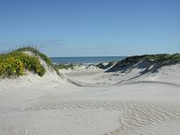
A dune is a landform composed of wind- or water-driven sand. It typically takes the form of a mound, ridge, or hill. An area with dunes is called a dune system or a dune complex. A large dune complex is called a dune field, while broad, flat regions covered with wind-swept sand or dunes, with little or no vegetation, are called ergs or sand seas. Dunes occur in different shapes and sizes, but most kinds of dunes are longer on the stoss (upflow) side, where the sand is pushed up the dune, and have a shorter slip face in the lee side. The valley or trough between dunes is called a dune slack.

<span class="mw-page-title-main">Cape Cod National Seashore</span> Protected area on Cape Cod, Massachusetts

The Cape Cod National Seashore (CCNS) encompasses 43,607 acres on Cape Cod, in Massachusetts. CCNS was created on August 7, 1961, by President John F. Kennedy, when he signed a bill enacting the legislation he first co-sponsored as a Senator a few years prior. It includes ponds, woods and beachfront of the Atlantic coastal pine barrens ecoregion. The CCNS includes nearly 40 miles (64 km) of seashore along the Atlantic-facing eastern shore of Cape Cod, in the towns of Provincetown, Truro, Wellfleet, Eastham, Orleans and Chatham. It is administered by the National Park Service.

<span class="mw-page-title-main">Cape Hatteras</span> Cape on the shoreline of Hatteras Island, North Carolina, United States

Cape Hatteras is a cape located at a pronounced bend in Hatteras Island, one of the barrier islands of North Carolina.

<span class="mw-page-title-main">Cape Lookout National Seashore</span>

Cape Lookout National Seashore preserves a 56-mile (90-km) long section of the Southern Outer Banks, or Crystal Coast, of North Carolina, USA, running from Ocracoke Inlet on the northeast to Beaufort Inlet on the southwest. Three undeveloped barrier islands make up the seashore - North and South Core Banks and Shackleford Banks. The seashore includes two historic villages on Core Banks, Shackleford's wild horses, and the Cape Lookout Lighthouse, which has a black-and-white diamond pattern. A visitor center for the seashore is located on Harkers Island.

<span class="mw-page-title-main">Gateway National Recreation Area</span> National Park Service unit in New York and New Jersey, United States

Gateway National Recreation Area is a 26,607-acre (10,767 ha) U.S. National Recreation Area in New York City and Monmouth County, New Jersey. It provides recreational opportunities that are not commonly found in a dense urban environment, including ocean swimming, bird watching, boating, hiking and camping. More than 8.7 million people visited Gateway National Recreation Area in 2022, making it the fourth-most visited unit of the National Park Service.

<span class="mw-page-title-main">Sleeping Bear Dunes National Lakeshore</span> Protected area

Sleeping Bear Dunes National Lakeshore is a U.S. national lakeshore in the northwestern Lower Peninsula of Michigan. Located within Benzie and Leelanau counties, the park extends along a 35-mile (56 km) stretch of Lake Michigan's eastern coastline, as well as North and South Manitou islands, preserving a total of 71,199 acres. The park is known for its outstanding natural features, including dune formations, forests, beaches, and ancient glacial phenomena. The lakeshore also contains many cultural features, including the 1871 South Manitou Island Lighthouse, three former stations of the Coast Guard, and an extensive rural historic farm district.

<span class="mw-page-title-main">Cape Hatteras Lighthouse</span> Lighthouse in North Carolina, United States

Cape Hatteras Light is a lighthouse located on Hatteras Island in the Outer Banks in the town of Buxton, North Carolina and is part of the Cape Hatteras National Seashore. The lighthouse's semi-unique pattern makes it easy to recognize and famous. It is often ranked high on lists of most beautiful, and famous lighthouses in the US.

<span class="mw-page-title-main">Pictured Rocks National Lakeshore</span> U.S. National Lakeshore on Lake Superior

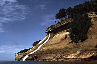
Pictured Rocks National Lakeshore is a U.S. National Lakeshore in the Upper Peninsula of Michigan, United States. It extends for 42 mi (68 km) along the shore of Lake Superior and covers 73,236 acres. The park has extensive views of the hilly shoreline between Munising and Grand Marais in Alger County, with picturesque rock formations, waterfalls, and sand dunes.

<span class="mw-page-title-main">Hatteras, North Carolina</span> Census-designated place in North Carolina, United States of America

Hatteras is an unincorporated village and census-designated place (CDP) in Dare County, North Carolina, United States, on the Outer Banks island of Hatteras, at its extreme southwestern tip. As of the 2010 census it had a population of 504. Immediately to the west of the village of Hatteras is Hatteras Inlet which separates Hatteras Island from the neighboring Ocracoke Island. North Carolina Highway 12 passes through the community linking it to Frisco to the east and Ocracoke to the west.

<span class="mw-page-title-main">Fire Island National Seashore</span> National park system unit in New York, United States

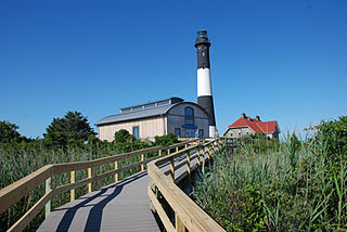
Fire Island National Seashore (FINS) is a United States National Seashore that protects a 26-mile (42 km) section of Fire Island, an approximately 30-mile (48 km) long and 0.5-mile (0.80 km) wide barrier island separated from Long Island by the Great South Bay. The island is part of New York State's Suffolk County and the Outer Barrier.

<span class="mw-page-title-main">National recreation area</span> Type of protected area in the United States

A national recreation area (NRA) is a protected area in the United States established by an Act of Congress to preserve enhanced recreational opportunities in places with significant natural and scenic resources. There are 40 NRAs, which emphasize a variety of activities for visitors, including hiking, camping, boating, fishing, swimming, biking, horseback riding, and wildlife viewing, in areas that include multiple-use management for both conservation and limited utilization of natural resources. They have diverse features and contexts, being established around reservoirs, in urban areas, and within forests. Due to their size, diversity of activities, and proximity to population centers, NRAs are among the most visited units of the National Park System, with six among the thirty most visited sites.

<span class="mw-page-title-main">Gulf Islands National Seashore</span> 96,000 underwater acres in Mississippi and Florida (US) managed by the National Park Service

Gulf Islands National Seashore is an American National seashore that offers recreation opportunities and preserves natural and historic resources along the Gulf of Mexico barrier islands of Florida and Mississippi. In 2022, it was the eighth-most visited unit of the National Park Service.

<span class="mw-page-title-main">Cape Hatteras National Seashore</span>

Cape Hatteras National Seashore is a United States national seashore which preserves the portion of the Outer Banks of North Carolina from Bodie Island to Ocracoke Island, stretching over 70 miles (110 km), and is managed by the National Park Service. Included within this section of barrier islands along N.C. 12, but outside the national seashore boundaries, are Pea Island National Wildlife Refuge and several communities, such as Rodanthe, Buxton, and Ocracoke. Cape Hatteras is a combination of natural and cultural resources, and provides a wide variety of recreational opportunities.

<span class="mw-page-title-main">Assateague Island National Seashore</span> Barrier island operated by the National Park Service of the United States

Assateague Island National Seashore is a unit of the National Park Service system of the U.S. Department of the Interior. Located on the East Coast along the Atlantic Ocean in Maryland and Virginia, Assateague Island is the largest natural barrier island ecosystem in the Middle Atlantic states region that remains predominantly unaffected by human development. Located within a three-hour drive to the east and south of Richmond, Washington, Baltimore, Wilmington, Philadelphia major metropolitan areas plus north of the several clustered smaller cities around Hampton Roads harbor of Virginia with Newport News, Hampton, Norfolk, Portsmouth, Chesapeake and Virginia Beach. The National Seashore offers a setting in which to experience a dynamic barrier island and to pursue a multitude of recreational opportunities. The stated mission of the park is to preserve and protect “unique coastal resources and the natural ecosystem conditions and processes upon which they depend, provide high-quality resource-based recreational opportunities compatible with resource protection and educate the public as to the values and significance of the area”.

<span class="mw-page-title-main">Outer Banks</span> Barrier islands in North Carolina, U.S.

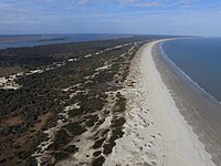
The Outer Banks are a 200 mi (320 km) string of barrier islands and spits off the coast of North Carolina and southeastern Virginia, on the east coast of the United States. They line most of the North Carolina coastline, separating Currituck Sound, Albemarle Sound, and Pamlico Sound from the Atlantic Ocean. A major tourist destination, the Outer Banks are known for their wide expanse of open beachfront and the Cape Hatteras National Seashore. The seashore and surrounding ecosystem are important biodiversity zones, including beach grasses and shrubland that help maintain the form of the land.

<span class="mw-page-title-main">Canaveral National Seashore</span> National Seashore in the state of Florida, U.S.

The Canaveral National Seashore (CANA) is a National Seashore located between New Smyrna Beach and Titusville, Florida, in Volusia and Brevard Counties. The park, located on a barrier island, was created on January 3, 1975, by an act of Congress. The park is split between Brevard and Volusia counties, with 9 miles of the seashore in Brevard County, and 15 miles of the seashore in Volusia County. CANA consists of 24 miles of beaches, dunes, mangrove wetlands, and a large portion of the Mosquito Lagoon. The Canaveral National Seashore is also the longest expanse of undeveloped land along the East Coast of Florida. The Canaveral National Seashore is home to more than 1,000 plant species and 310 bird species. CANA occupies 57,662 acres (23,335 ha). There are 3 major beach sections in the seashore. The southern section is Playalinda Beach, the middle section is Klondike Beach, and the northern section is Apollo Beach.

<span class="mw-page-title-main">Cape Lookout Lighthouse</span> Lighthouse in North Carolina, US

The Cape Lookout Lighthouse is a 163-foot-high lighthouse located on the southern Outer Banks of North Carolina. It flashes every 15 seconds and is visible at least 12 miles out to sea and up to 19 miles. It is one of the very few lighthouses that operate during the day. It became fully automated in 1950. The Cape Lookout Lighthouse is the only such structure in the United States to bear the checkered daymark, intended not only for differentiation between similar light towers, but also to show direction. The center of the black diamonds points in a north-south direction, while the center of the white diamonds points east-west.

<span class="mw-page-title-main">Atlantic Flyway</span> Major north-south flyway for migratory birds in North America

The Atlantic Flyway is a major north-south flyway for migratory birds in North America. The route generally starts in Greenland, then follows the Atlantic coast of Canada, then south down the Atlantic Coast of the United States to the tropical areas of South America and the Caribbean. Every year, migratory birds travel up and down this route following food sources, heading to breeding grounds, or traveling to overwintering sites.

<span class="mw-page-title-main">History of the National Park Service</span>

Since 1872 the United States National Park System has grown from a single, public reservation called Yellowstone National Park to include 430 natural, historical, recreational, and cultural areas throughout the United States, its territories, and island possessions. These areas include National Parks, National Monuments, National Memorials, National Military Parks, National Historic Sites, National Parkways, National Recreation Areas, National Seashores, National Scenic Riverways, and National Scenic Trails.

References

  1. 1 2 3 4 5 6 7 The National Parks: Index 2012–2016 (PDF). Washington, D.C.: National Park Service. ISBN   978-0-16-093209-0 . Retrieved January 28, 2017.
  2. "Annual Visitation by Park Type or Region for: 2017 By Park Type". Integrated Resource Management Applications Portal. National Park Service. Retrieved February 16, 2019.
  3. Waterman, Jon (August 6, 2020). "Water, Sand and Plenty of Elbow Room on 8 Wild, Protected Coastlines". The New York Times. ISSN   0362-4331 . Retrieved August 13, 2020.
  4. 1 2 Saunders, Stephen; et al. (August 2012). "Atlantic National Seashores in Peril The Threats of Climate Disruption" (PDF). National Resources Defense Council. Retrieved February 16, 2019.
  5. "National Seashores: On the Front Line of Climate Change". Coastal Review Online. November 7, 2012. Retrieved February 17, 2019.
  6. Pendleton, Elizabeth A.; et al. (2007). "Coastal Change-Potential Assessment of Sleeping Bear Dunes, Indiana Dunes, and Apostle Islands National Lakeshores to Lake-Level Changes" (PDF). U.S. Geological Survey. Retrieved February 18, 2019.
  7. "[USC03] 16 USC 577a: Conserving shore line beauty for recreational use of public lands in northern Minnesota; regulation of logging". United States Code. Office of the Law Revision Counsel. Retrieved February 17, 2019.
  8. 1 2 3 Binkley, Cameron (2007). The Creation and Establishment of Cape Hatteras National Seashore: The Great Depression through Mission 66 (PDF). National Park Service.
  9. "National Park Service: Atlantic and Gulf Coasts Recreation Area Survey (Summary of Findings and Recommendations)". National Park Service. Retrieved February 17, 2019.
  10. Unrau, Harlan; Williss, G. Frank (1983). Administrative history: expansion of the National Park Service in the 1930s (PDF). National Park Service. p. 155.
  11. Wirth, Conrad (1980). "Parks, Politics, and the People (Chapter 9)". University of Oklahoma Press. Retrieved February 17, 2019 via National Park Service.
  12. 1 2 Mackintosh, Barry (2005). The National Parks: Shaping the System. U.S. Department of the Interior. pp. 73–75. ISBN   978-0-912627-73-1.
  13. Runte, Alfred (1997). "National Parks: The American Experience (Chapter 11)". University of Nebraska Press. Retrieved March 8, 2021.
  14. Thiele, Rebecca. "Park Service: Indiana Dunes Shouldn't Be A National Park". WBAA. Retrieved February 17, 2019.
  15. Carden, Dan; Pete, Joseph S. (February 15, 2019). "Indiana Dunes National Lakeshore now is America's newest national park". The Times of Northwest Indiana. Retrieved February 17, 2019.
  16. 1 2 "National Park System Areas Listed in Chronological Order of Date Authorized under DOI" (PDF). National Park Service. June 27, 2005. Archived from the original (PDF) on March 11, 2012. Retrieved January 18, 2010.
  17. "Assateague Island National Seashore". National Park Service. Retrieved January 22, 2011.
  18. "Canaveral National Seashore". National Park Service. Retrieved January 22, 2011.
  19. "Cape Cod National Seashore". National Park Service. Retrieved January 22, 2011.
  20. "Cape Hatteras National Seashore". National Park Service. Retrieved January 22, 2011.
  21. "Cape Lookout National Seashore". National Park Service. Retrieved January 22, 2011.
  22. "Cumberland Island National Seashore". National Park Service. Retrieved January 22, 2011.
  23. "Fire Island National Seashore". National Park Service. Retrieved January 22, 2011.
  24. "Gulf Islands National Seashore". National Park Service. Retrieved January 22, 2011.
  25. "Padre Island National Seashore". National Park Service. Retrieved January 22, 2011.
  26. "Point Reyes National Seashore". National Park Service. Retrieved January 22, 2011.
  27. "Apostle Islands National Lakeshore". National Park Service. Retrieved January 22, 2011.
  28. "Visit Wilderness". wilderness.net. Retrieved December 14, 2023.
  29. "Pictured Rocks National Lakeshore". National Park Service. Retrieved January 22, 2011.
  30. "Sleeping Bear Dunes National Lakeshore". National Park Service. Retrieved January 22, 2011.