 Point Reyes light tower in 1871, shortly after completion. (Eadweard Muybridge photograph)
 Point Reyes Light Station, shortly after the completion of the tower but before the construction of the work room.
 Point Reyes Light Station before automation (undated USCG photo).
 The automated light on fog signal building.
 Detail of light tower and lantern house in 2009, with first order Fresnel lens visible.
 Interior of the light tower, ground floor.
 First order Fresnel lens at Point Reyes lighthouse after a 15-month restoration project completed in November 2019
 Long stairs leading down to the lighthouse.
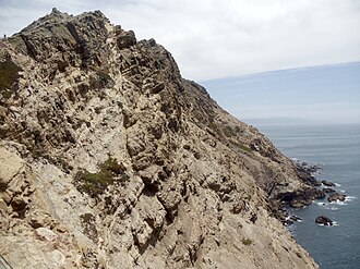 The prominent, upward-sloping Salinian Block formation can be seen here from the Point Reyes Lighthouse.
 "Supertyphon" air horn, the last kind of fog horn used at the site until its automation in 1975
 Point Reyes Light after the restoration in 2019 | |
 | |
| Location | Point Reyes Gulf of the Farallones California United States |
|---|---|
| Coordinates | 37°59′44″N123°01′24″W / 37.995621°N 123.023215°W |
| Tower | |
| Constructed | 1870 |
| Foundation | concrete base |
| Construction | cast iron tower |
| Automated | 1975 |
| Height | 35 feet (11 m) |
| Shape | 16-sided tower with balcony and lantern |
| Markings | white tower, red lantern roof |
| Operator | Point Reyes National Seashore [1] [2] |
| Heritage | National Register of Historic Places listed place |
| Light | |
| Focal height | 265 feet (81 m) |
| Lens | First order Fresnel lens |
| Range | 21 nautical miles; 39 kilometres (24 mi) |
| Characteristic | Fl W 5s. |
Point Reyes Light Station | |
| Architect | Marston, Phineas F. |
| MPS | Light Stations of California MPS |
| NRHP reference No. | 91001100 |
| Added to NRHP | September 3, 1991 [3] |
The Point Reyes Lighthouse, also known as Point Reyes Light or the Point Reyes Light Station, is a lighthouse in the Gulf of the Farallones on Point Reyes in Point Reyes National Seashore, located in Marin County, California, United States.
Contents
The park's adjacent Lighthouse Visitor Center features exhibits about the lighthouse and the park's marine life and natural history. Visitors can climb about 300 steps down to the lighthouse itself, weather permitting. The main chamber of the lighthouse, known as the Lens Room, features the Fresnel lens and clockwork mechanism, and is open to the public on a limited basis.


