A batholith is a large mass of intrusive igneous rock, larger than 100 square kilometres (40 sq mi) in area, that forms from cooled magma deep in the Earth's crust. Batholiths are almost always made mostly of felsic or intermediate rock types, such as granite, quartz monzonite, or diorite.

ThePacific Coast Ranges, are the series of mountain ranges that stretch along the West Coast of North America from Alaska south to Northern and Central Mexico. Although they are commonly thought to be the westernmost mountain range of the continental United States and Canada, the geologically distinct Insular Mountains of Vancouver Island lie further west.

The Peninsular Ranges are a group of mountain ranges that stretch 1,500 km (930 mi) from Southern California to the southern tip of the Baja California Peninsula; they are part of the North American Coast Ranges, which run along the Pacific Coast from Alaska to Mexico. Elevations range from 500 to 10,834 feet.

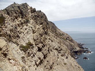
Bodega Head is a small promontory on the Pacific coast of northern California in the United States. It is located in Sonoma County at 38.311°N 123.066°W, approximately 40 mi (64 km) northwest of San Francisco and approximately 20 mi (32 km) west of Santa Rosa.

The Santa Lucia Mountains or Santa Lucia Range is a rugged mountain range in coastal central California, running from Carmel southeast for 140 miles (230 km) to the Cuyama River in San Luis Obispo County. The range is never more than 11 miles (18 km) from the coast. The range forms the steepest coastal slope in the contiguous United States. Cone Peak at 5,158 feet (1,572 m) tall and three miles (5 km) from the coast, is the highest peak in proximity to the ocean in the lower 48 United States. The range was a barrier to exploring the coast of central California for early Spanish explorers.
In geology, a terrane is a crust fragment formed on a tectonic plate and accreted or "sutured" to crust lying on another plate. The crustal block or fragment preserves its own distinctive geologic history, which is different from that of the surrounding areas—hence the term "exotic" terrane. The suture zone between a terrane and the crust it attaches to is usually identifiable as a fault. A sedimentary deposit that buries the contact of the terrane with adjacent rock is called an overlap formation. An igneous intrusion that has intruded and obscured the contact of a terrane with adjacent rock is called a stitching pluton.
The Nevadan orogeny occurred along the western margin of North America during the Middle Jurassic to Early Cretaceous time which is approximately from 155 Ma to 145 Ma. Throughout the duration of this orogeny there were at least two different kinds of orogenic processes occurring. During the early stages of orogenesis an "Andean type" continental magmatic arc developed due to subduction of the Farallon oceanic plate beneath the North American Plate. The latter stages of orogenesis, in contrast, saw multiple oceanic arc terranes accreted onto the western margin of North America in a "Cordilleran type" accretionary orogen. Deformation related to the accretion of these volcanic arc terranes is mostly limited to the western regions of the resulting mountain ranges and is absent from the eastern regions. In addition, the deformation experienced in these mountain ranges is mostly due to the Nevadan orogeny and not other external events such as the more recent Sevier and Laramide Orogenies. It is noted that the Klamath Mountains and the Sierra Nevada share similar stratigraphy indicating that they were both formed by the Nevadan orogeny. In comparison with other orogenic events, it appears that the Nevadan Orogeny occurred rather quickly taking only about 10 million years as compared to hundreds of millions of years for other orogenies around the World.
The Smartville Block, also called the Smartville Ophiolite, Smartville Complex, or Smartville Intrusive Complex, is a geologic terrane formed in the ocean from a volcanic island arc that was accreted onto the North American Plate during the late Jurassic. The collision created sufficient crustal heating to drive mineral-laden water up through numerous fissures along the contact zone. When these cooled, among the precipitating minerals was gold. Associated with the Western Metamorphic Belt of the Sierra Nevada foothills it extends from the central Sierra Nevada mountain range, due west, under a section of the Central Valley and California Coast Ranges, in northern California. The ophiolitic sequence found in this terrane is one of several major ophiolites found in California. Ophiolites are crustal and upper-mantle rocks from the ocean floor that have been moved on land. Ophiolites have been studied extensively regarding the movement of crustal rocks by plate tectonics.
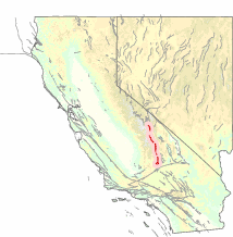
The Sierra Nevada Batholith is a large batholith which forms the core of the Sierra Nevada mountain range in California, exposed at the surface as granite.
The Sierra Nevada Fault is an active seismic fault along the eastern edge of the Sierra Nevada mountain block in California. It forms the eastern escarpment of the Sierra Nevada, extending roughly 600 km (370 mi) from just north of the Garlock Fault to the Cascade Range.
The Kern Canyon Fault is a dextral strike-slip fault (horizontal) that runs roughly around 150 km (93 mi) beside the Kern Canyon River through the mountainous area of the Southern Sierra Nevada Batholith. The fault was a reverse fault in the Early Cretaceous epoch during the primal stages of the Farallon Plate subduction beneath the North American Continental Plate and fully transitioned into a strike-slip shear zone during the Late Cretaceous.
In early Triassic time, an extensive volcanic arc system, called the Sierran Arc began to develop along the western margin of the North American continent. In Southern California, this volcanic arc would develop throughout the Mesozoic Era to become the geologic regions known as the Sierra Nevada Batholith, the Peninsular Ranges Batholith,, and other plutonic and volcanic centers throughout the greater Mojave Desert region.

Sierra de Salinas is a mountain range in the California Coast Ranges, located in central Monterey County, California. The range is a part of the Salinian Block and lies between the Santa Lucia Range to the west and the Salinas Valley, Salinas River, and Gabilan Range to the east.

The Algoman orogeny, known as the Kenoran orogeny in Canada, was an episode of mountain-building (orogeny) during the Late Archean Eon that involved repeated episodes of continental collisions, compressions and subductions. The Superior province and the Minnesota River Valley terrane collided about 2,700 to 2,500 million years ago. The collision folded the Earth's crust and produced enough heat and pressure to metamorphose the rock. Blocks were added to the Superior province along a 1,200 km (750 mi) boundary that stretches from present-day eastern South Dakota into the Lake Huron area. The Algoman orogeny brought the Archaen Eon to a close, about 2,500 million years ago; it lasted less than 100 million years and marks a major change in the development of the Earth's crust.

The geological history of Point Lobos, regarding the Point Lobos headland on the Central Coast in Monterey County, California.
The Sierra Nevada–Great Valley Block (SNGV) is a section of the earth's crust in California encompassing most of the region east of the Great Valley fault system which runs along the eastern foot of the Coast Ranges, and west of the Sierra Nevada Fault which runs along the foot of the Sierra Nevada's eastern scarp. To the south, the block is bounded by the Garlock Fault. The northern bound is not well defined at present, but generally runs along a line extending across the northern Sacramento Valley.
The Rescue Lineament-Bear Mountains fault zone, in eastern California, is a series of co-axial faults located in the western foothills of the Sierra Nevada.

The Grouse Creek block is a Precambrian basement province of 2.45 to 2.70 billion year old orthogneisses. The Grouse Creek block is one of several Proterozoic and Archean accreted terranes that lie to the north and west of the Wyoming craton, including the Farmington Canyon Complex, the Selway terrane, the Medicine Hat block and the Priest River complex. Together, these terranes comprise part of the basement rock of the North American continent and have been critical to studies of crustal accretion in the Precambrian. Ongoing study of the Grouse Creek block will contribute to understanding the paleogeography of the Wyoming craton prior to its incorporation into the supercontinent Laurentia approximately 1.86 billion years ago. The name was proposed by David Foster and others.

The Famatinian orogeny is an orogeny that predates the rise of the Andes and that took place in what is now western South America during the Paleozoic, leading to the formation of the Famatinian orogen also known as the Famatinian belt. The Famatinian orogeny lasted from the Late Cambrian to at least the Late Devonian and possibly the Early Carboniferous, with orogenic activity peaking about 490 to 460 million years ago. The orogeny involved metamorphism and deformation in the crust and the eruption and intrusion of magma along a Famatinian magmatic arc that formed a chain of volcanoes. The igneous rocks of the Famatinian magmatic arc are of calc-alkaline character and include gabbros, tonalites and granodiorites. The youngest igneous rocks of the arc are granites.
The geology of California is highly complex, with numerous mountain ranges, substantial faulting and tectonic activity, rich natural resources and a history of both ancient and comparatively recent intense geological activity. The area formed as a series of small island arcs, deep-ocean sediments and mafic oceanic crust accreted to the western edge of North America, producing a series of deep basins and high mountain ranges.