Related Research Articles

Southern California is a geographic and cultural region that generally comprises the southern portion of the U.S. state of California. It includes the Los Angeles metropolitan area and also the Inland Empire. The region generally contains ten of California's 58 counties: Imperial, Kern, Los Angeles, Orange, Riverside, San Bernardino, San Diego, Santa Barbara, San Luis Obispo and Ventura counties.

Santa Barbara County, officially the County of Santa Barbara, is located in Southern California. As of the 2020 census, the population was 448,229. The county seat is Santa Barbara, and the largest city is Santa Maria.

The Transverse Ranges are a group of mountain ranges of southern California, in the Pacific Coast Ranges physiographic region in North America. The Transverse Ranges begin at the southern end of the California Coast Ranges and lie within Santa Barbara, Ventura, Los Angeles, San Bernardino, Riverside and Kern counties. The Peninsular Ranges lie to the south. The name Transverse Ranges is due to their east–west orientation, making them transverse to the general northwest–southeast orientation of most of California's coastal mountains.

The Santa Ynez Mountains are a portion of the Transverse Ranges, part of the Pacific Coast Ranges of the west coast of North America. It is the westernmost range in the Transverse Ranges.
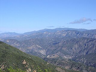
The San Rafael Mountains are a mountain range in central Santa Barbara County, California, U.S., separating the drainages of the Santa Ynez River and the Santa Maria River. They are part of the Transverse Ranges system of Southern California which in turn are part of the Pacific Coast Ranges system of western North America.

The Santa Ynez River is one of the largest rivers on the Central Coast of California. It is 92 miles (148 km) long, flowing from east to west through the Santa Ynez Valley, reaching the Pacific Ocean at Surf, near Vandenberg Space Force Base and the city of Lompoc.

The Santa Ynez Valley is located in Santa Barbara County, California, between the Santa Ynez Mountains to the south and the San Rafael Mountains to the north. The Santa Ynez River flows through the valley from east to west. The Santa Ynez Valley is separated from the Los Alamos Valley, to the northwest, by the Purisima Hills, and from the Santa Maria Valley by the Solomon Hills. The Santa Rita Hills separate the Santa Ynez Valley from the Santa Rita and Lompoc Valleys to the west.

The Dick Smith Wilderness is a wilderness area in the mountains of eastern Santa Barbara County, California, United States, with a portion in Ventura County. It is completely contained within the Los Padres National Forest, and is northeast of the city of Santa Barbara and north of the city of Ojai. It is most easily accessible from two trailheads off State Route 33, which runs north from Ojai. It is adjacent to the large San Rafael Wilderness on the west and the Matilija Wilderness on the south. Across Highway 33 to the east, and also in the Los Padres National Forest, is the large Sespe Wilderness.

The Sisquoc Formation is a sedimentary geologic unit widespread in Southern California, both on the coast and in mountains near the coast. Overlying the Monterey Formation, it is of upper Miocene and lower Pliocene age. The formation consists of claystone, mudstone, siltstone, shale, diatomite, and conglomerates, with considerable regional variation, and was deposited in a moderately deep marine environment at a depth of approximately 500–5,000 feet (150–1,520 m). Since some of its diatomites, along with those of the underlying Monterey Formation, are of unusual purity and extent, they can be mined as diatomaceous earth. France-based Imerys operates a mine in the Sisquoc and Monterey Formations in the hills south of Lompoc, California, the largest such operation in the world.
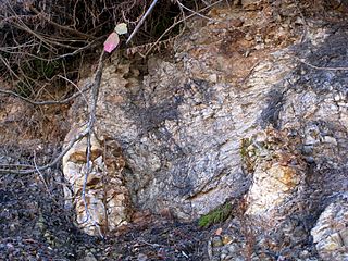
The Rincon Formation is a sedimentary geologic unit of Lower Miocene age, abundant in the coastal portions of southern Santa Barbara County, California eastward into Ventura County. Consisting of massive to poorly bedded shale, mudstone, and siltstone, it weathers readily to a rounded hilly topography with clayey, loamy soils in which landslides and slumps are frequent. It is recognizable on the south slopes of the Santa Ynez Mountains as the band at the base of the mountains which supports grasses rather than chaparral. Outcrops of the unit are infrequent, with the best exposures on the coastal bluffs near Naples, in the San Marcos Foothills, at the Tajiguas Landfill, and in road cuts. The geologic unit is notorious as a source of radon gas related to its high uranium content, released by radioactive decay.

The Coldwater Sandstone is a sedimentary geologic unit of Eocene age found in Southern California, primarily in and south of the Santa Ynez Mountains of Santa Barbara County, and east into Ventura County. It consists primarily of massive arkosic sandstone with some siltstone and shale. Being exceptionally resistant to erosion, outcrops of the Coldwater form some of the most dramatic terrain on the south slope of the Santa Ynez Mountains, with immense white sculpted slabs forming peaks, hogback ridges, and sheer cliff faces.

The Juncal Formation is a prominent sedimentary geologic unit of Eocene age found in and north of the Santa Ynez Mountain range in southern and central Santa Barbara County and central Ventura County, California. An enormously thick series of sediments deposited over millions of years in environments ranging from nearshore to deep water, it makes up much of the crest of the Santa Ynez range north of Montecito, as well as portions of the San Rafael Mountains in the interior of the county. Its softer shales weather to saddles and swales, supporting a dense growth of brush, and its sandstones form prominent outcrops.
The Jalama Formation is a sedimentary rock formation widespread in southern Santa Barbara County and northern Ventura County, southern California. Of the Late Cretaceous epoch, the unit consists predominantly of clay shale with some beds of sandstone.
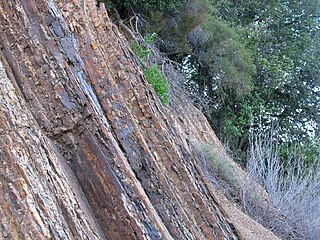
Santa Ynez Fault is a left-reverse fault in Santa Barbara County of California. Its length is at least 130 km., running through Santa Ynez and north of nearby Santa Barbara. The Santa Ynez Mountains were uplifted within the last 5 million years, mostly along this fault, which marks the north slope of the range.

The Santa Clara valley aquifer is a groundwater aquifer located in the southern San Francisco Bay Area. The geology of the Santa Clara valley aquifer consists of a complex stratigraphy of permeable and impermeable units. Management of aquifer resources is associated with the Santa Clara Valley Water District.
The 1925 Santa Barbara earthquake hit the area of Santa Barbara, California on June 29, with a moment magnitude between 6.5 and 6.8 and a maximum Mercalli Intensity of IX (Violent). It resulted in 13 deaths and destroyed the historic center of the city, with damage estimated at $8 million.

The Santa Ynez Band of Chumash Mission Indians is a federally recognized tribe of Chumash, an indigenous people of California, in Santa Barbara. Their name for themselves is Samala. The locality of Santa Ynez is referred to as ’alaxulapu in Chumashan language.
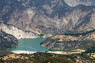
Gibraltar Dam is located on the Santa Ynez River, in southeastern Santa Barbara County, California, in the United States. Forming Gibraltar Reservoir, the dam is owned by the city of Santa Barbara. Originally constructed in 1920 and expanded in 1948, the dam and reservoir are located in a remote part of the Los Padres National Forest.

Salsipuedes Creek is a 9.9 miles (15.9 km) long stream, flowing north to join the Santa Ynez River just southeast of Lompoc in Santa Barbara County, California. Salsipuedes Creek, along with its major tributary, El Jaro Creek, is the largest tributary to the lower Santa Ynez River, shortly before the river reaches the Pacific Ocean.
The geology of California is highly complex, with numerous mountain ranges, substantial faulting and tectonic activity, rich natural resources and a history of both ancient and comparatively recent intense geological activity. The area formed as a series of small island arcs, deep-ocean sediments and mafic oceanic crust accreted to the western edge of North America, producing a series of deep basins and high mountain ranges.
References
- ↑ Sylvester, A. G.; Darrow, A. C. (1979), "Structure and neotectonics of the western Santa Ynez fault system in southern California", Tectonophysics, 52 (1–4): 389–405, Bibcode:1979Tectp..52..389S, doi:10.1016/0040-1951(79)90253-1