
Southern California is a geographic and cultural region that generally comprises the southern portion of the U.S. state of California. It includes the Los Angeles metropolitan area and also the Inland Empire. The region generally contains ten of California's 58 counties: Imperial, Kern, Los Angeles, Orange, Riverside, San Bernardino, San Diego, Santa Barbara, San Luis Obispo and Ventura counties.

The San Andreas Fault is a continental right-lateral strike-slip transform fault that extends roughly 1,200 kilometers (750 mi) through the Californias. It forms the tectonic boundary between the Pacific Plate and the North American Plate. Traditionally, for scientific purposes, the fault has been classified into three main segments, each with different characteristics and a different degree of earthquake risk. The average slip rate along the entire fault ranges from 20 to 35 mm per year.

A thrust fault is a break in the Earth's crust, across which older rocks are pushed above younger rocks.
Northridge is a neighborhood in the San Fernando Valley region of the City of Los Angeles. The community is home to California State University, Northridge, and the Northridge Fashion Center.
A blind thrust earthquake occurs along a thrust fault that does not show signs on the Earth's surface, hence the designation "blind". Such faults, being invisible at the surface, have not been mapped by standard surface geological mapping. Sometimes they are discovered as a by-product of oil exploration seismology; in other cases their existence is not suspected.
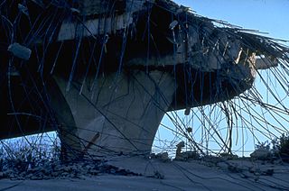
The 1994 Northridge earthquake was a moment magnitude 6.7, blind thrust earthquake that occurred on January 17, 1994, at 4:30:55 a.m. PST in the San Fernando Valley region of the City of Los Angeles. The quake had a duration of approximately 10–20 seconds, and its peak ground acceleration of 1.82 g was the highest ever instrumentally recorded in an urban area in North America. Shaking was felt as far away as San Diego, Turlock, Las Vegas, Richfield, Phoenix, and Ensenada. The peak ground velocity at the Rinaldi Receiving Station was 183 cm/s, the fastest ever recorded.

The 1971 San Fernando earthquake occurred in the early morning of February 9 in the foothills of the San Gabriel Mountains in southern California. The unanticipated thrust earthquake had a magnitude of 6.5 on the scale and 6.6 on the scale, and a maximum Mercalli intensity of XI (Extreme). The event was one in a series that affected Los Angeles county in the late 20th century. Damage was locally severe in the northern San Fernando Valley and surface faulting was extensive to the south of the epicenter in the mountains, as well as urban settings along city streets and neighborhoods. Uplift and other effects affected private homes and businesses.
The Alquist-Priolo Earthquake Fault Zoning Act was signed into California law on December 22, 1972, to mitigate the hazard of surface faulting to structures for human occupancy.
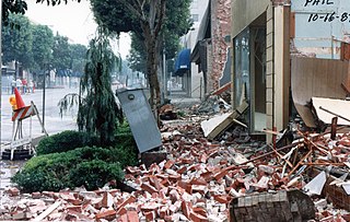
The 1987 Whittier Narrows earthquake occurred in the southern San Gabriel Valley and surrounding communities of Southern California, United States, at on October 1. The moderate magnitude 5.9 blind thrust earthquake was centered several miles north of Whittier in the town of Rosemead, had a relatively shallow depth, and was felt throughout southern California and southern Nevada. Many homes and businesses were affected, along with roadway disruptions, mainly in Los Angeles and Orange counties. Damage estimates ranged from $213–358 million, with 200 injuries, three directly-related deaths, and five additional fatalities that were associated with the event.
The 1999 Hector Mine earthquake occurred in Southern California, United States, on October 16 at 02:46:50 PDT. Its moment magnitude was 7.1 and the earthquake was preceded by 12 foreshocks, the largest of which had a magnitude of 3.8. The event is thought to have been triggered by the 1992 Landers earthquake which occurred seven years earlier. It also deformed nearby faults vertically and horizontally. The earthquake's hypocenter was at a depth of 20 kilometers and its epicenter at 34.603° N 116.265° W.

Northridge Fashion Center is a large shopping mall located in Northridge, Los Angeles, California. It opened in 1971. It was severely damaged during the Northridge earthquake in 1994, but renovated extensively in 1995, 1998, and 2003. The mall's anchor stores are J. C. Penney, two Macy's locations, Dave and Buster’s, and an AMC Theatres formerly owned by Pacific Theatres.

The 1992 Landers earthquake occurred on Sunday, June 28 with an epicenter near the town of Landers, California, in San Bernardino County. The shock had a moment magnitude of 7.3 and a maximum Mercalli intensity of IX (Violent).
The 1952 Kern County earthquake occurred on July 21 in the southern San Joaquin Valley and measured 7.3 on the moment magnitude scale. The main shock occurred at 4:52 am Pacific Daylight Time, killed 12 people, injured hundreds more and caused an estimated $60 million in property damage. A small sector of damage near Bealville corresponded to a maximum Mercalli intensity of XI (Extreme), though this intensity rating was not representative of the majority of damage. The earthquake occurred on the White Wolf Fault near the community of Wheeler Ridge and was the strongest to occur in California since the 1906 San Francisco earthquake.
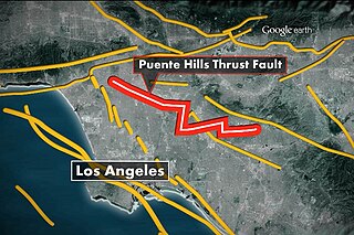
The Puente Hills Fault is an active geological fault that is located in the Los Angeles Basin in California. The thrust fault was discovered in 1999 and runs about 40 km (25 mi) in three discrete sections from the Puente Hills region in the southeast to just south of Griffith Park in the northwest. The fault is known as a blind thrust fault, as the fault plane does not extend to the surface. Large earthquakes on the fault are relatively infrequent but computer modeling has indicated that a major event could have substantial impact in the Los Angeles area. The fault is now thought to be responsible for one moderate earthquake in 1987 and another light event that took place in 2010, with the former causing considerable damage and deaths.
The 1991 Sierra Madre earthquake occurred on June 28 at with a moment magnitude of 5.6 and a maximum Mercalli intensity of VII. The thrust earthquake resulted in two deaths, around 100 injuries, and damage estimated at $33.5–40 million. The event occurred beneath the San Gabriel Mountains on the Clamshell–Sawpit Fault, which is a part of the Sierra Madre–Cucamonga Fault System. Instruments captured the event at a number of strong motion stations in Southern California.

Situated at the boundary to the San Gabriel Valley and San Fernando Valley, the Sierra Madre Fault Zone runs along the southern edge of the San Gabriel Mountains for a total of 95 kilometers (59 mi), where the northwesternmost 19 km (12 mi) comprises the San Fernando Fault. A 1980s paleoseismic study that included a trench investigation and mapping revealed that a major earthquake had most likely not occurred to the east of the San Fernando rupture area for at least the last several thousand, and possibly the last 11,000 years.
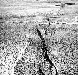
In seismology, surface rupture is the visible offset of the ground surface when an earthquake rupture along a fault affects the Earth's surface. Surface rupture is opposed by buried rupture, where there is no displacement at ground level. This is a major risk to any structure that is built across a fault zone that may be active, in addition to any risk from ground shaking. Surface rupture entails vertical or horizontal movement, on either side of a ruptured fault. Surface rupture can affect large areas of land.

In seismology, a buried rupture earthquake, or blind earthquake, is an earthquake which does not produce a visible offset in the ground along the fault. When the fault in question is a thrust fault, the earthquake is known as a blind thrust earthquake.
Elysian Park Fault is an active blind thrust fault located in Central Los Angeles, California. Approximately 20 km long, the fault is believed to able to produce a destructive earthquake of magnitude 6.2–6.7, about every 500–1,300 years, similar in size and frequency to the 1971 San Fernando earthquake or 1994 Northridge earthquake.

The 2014 La Habra earthquake was a magnitude 5.1 earthquake that occurred on March 28, 2014, at 9:09:42 p.m. PDT. Although given the name "La Habra" it was centered in Brea, a city in northern Orange County. Despite its moderate magnitude, it had a maximum Mercalli intensity of VII, and caused a total of $10.8 million in damage. Thirteen water mains broke in Fullerton, forcing roughly 70 families to be displaced from their homes after they were declared temporarily uninhabitable.
