
The San Andreas Fault is a continental right-lateral strike-slip transform fault that extends roughly 1,200 kilometers (750 mi) through the U.S. state of California. It forms part of the tectonic boundary between the Pacific Plate and the North American Plate. Traditionally, for scientific purposes, the fault has been classified into three main segments, each with different characteristics and a different degree of earthquake risk. The average slip rate along the entire fault ranges from 20 to 35 mm per year.

In geology, a fault is a planar fracture or discontinuity in a volume of rock across which there has been significant displacement as a result of rock-mass movements. Large faults within Earth's crust result from the action of plate tectonic forces, with the largest forming the boundaries between the plates, such as the megathrust faults of subduction zones or transform faults. Energy release associated with rapid movement on active faults is the cause of most earthquakes. Faults may also displace slowly, by aseismic creep.
The Walker Lane is a geologic trough roughly aligned with the California/Nevada border southward to where Death Valley intersects the Garlock Fault, a major left lateral, or sinistral, strike-slip fault. The north-northwest end of the Walker Lane is between Pyramid Lake in Nevada and California's Lassen Peak where the Honey Lake Fault Zone, the Warm Springs Valley Fault, and the Pyramid Lake Fault Zone meet the transverse tectonic zone forming the southern boundary of the Modoc Plateau and Columbia Plateau provinces. The Walker Lane takes up 15 to 25 percent of the boundary motion between the Pacific Plate and the North American Plate, the other 75 percent being taken up by the San Andreas Fault system to the west. The Walker Lane may represent an incipient major transform fault zone which could replace the San Andreas as the plate boundary in the future.

The Furnace Creek Fault Zone (FCFZ) is a geological fault that is located in Eastern California and southwestern Nevada. The right lateral-moving (dextral) fault extends for some 200 km (120 mi) between a connection with the Death Valley Fault Zone in the Amargosa Valley and northward to a termination in the Fish Lake Valley of southwest Nevada. The northern segment of the FCFZ is also referred to as the Fish Lake Valley Fault Zone. The FCFZ is considered an integral part of the Walker Lane.

The Pyramid Lake Fault Zone is an active right lateral-moving (dextral) geologic fault located in western Nevada. It is considered an integral part of the Walker Lane.
The 1855 Wairarapa earthquake occurred on 23 January at about 9.17 p.m., affecting much of the Cook Strait area of New Zealand, including Marlborough in the South Island and Wellington and the Wairarapa in the North Island. In Wellington, close to the epicentre, shaking lasted for at least 50 seconds. The moment magnitude of the earthquake has been estimated as 8.2, the most powerful recorded in New Zealand since systematic European colonisation began in 1840. This earthquake was associated with the largest directly observed movement on a strike-slip fault, maximum 18 metres (59 ft). This was later revised upward to about 20 m (66 ft) slip, with a local peak of 8 m (26 ft) vertical displacement on lidar studies. It has been suggested that the surface rupture formed by this event helped influence Charles Lyell to link earthquakes with rapid movement on faults.
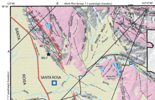
At 04:56 and 06:19 UTC on October 2, 1969, a pair of earthquakes of magnitude 5.6 and 5.7, respectively, struck the city of Santa Rosa, California, killing one person and damaging buildings. The maximum felt intensity for the two events was VII and VIII (Severe) respectively on the Mercalli intensity scale. The $8.35 million cost of the earthquakes went mostly to replace buildings damaged beyond repair. There were at least 200 aftershocks after the initial pair of earthquakes. At the time they were the largest earthquakes to affect the northern San Francisco Bay Area since the 1906 San Francisco earthquake.

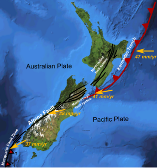
The Marlborough fault system is a set of four large dextral strike-slip faults and other related structures in the northern part of South Island, New Zealand, which transfer displacement between the mainly transform plate boundary of the Alpine fault and the mainly destructive boundary of the Kermadec Trench, and together form the boundary between the Australian and Pacific Plates.
The Wairau Fault is an active dextral strike-slip fault in the northeastern part of South Island, New Zealand. It forms part of the Marlborough Fault System, which accommodates the transfer of displacement along the oblique convergent boundary between the Indo-Australian Plate and Pacific Plate, from the transform Alpine Fault to the Hikurangi Trench subduction zone.
The Awatere Fault is an active dextral strike-slip fault in the northeastern part of South Island, New Zealand. It forms part of the Marlborough Fault System, which accommodates the transfer of displacement along the oblique convergent boundary between the Indo-Australian Plate and Pacific Plate, from the transform Alpine Fault to the Hikurangi Trench subduction zone. The 1848 Marlborough earthquake was caused by rupture of the whole of the eastern section of the Awatere Fault.
The Clarence Fault is an active dextral strike-slip fault in the northeastern part of South Island, New Zealand. It forms part of the Marlborough Fault System, which accommodates the transfer of displacement along the oblique convergent boundary between the Indo-Australian Plate and Pacific Plate, from the transform Alpine Fault to the Hikurangi Trench subduction zone.
The North Island Fault System (NIFS) is a set of southwest–northeast trending seismically-active faults in the North Island of New Zealand that carry much of the dextral strike-slip component of the oblique convergence of the Pacific Plate with the Australian Plate. However despite at least 3 km (1.9 mi) of uplift of the axial ranges in the middle regions of the fault system during the last 10 million years most of the shortening on this part of the Hikurangi Margin is accommodated by subduction.
The 1892 Laguna Salada earthquake occurred at . It had an estimated moment magnitude of 7.1–7.2 and a maximum perceived intensity of VIII (Severe). The shock was centered near the Mexico–United States border and takes its name from a large dry lake bed in Baja California, Mexico. There were no reported casualties, but the event affected the then largely-uninhabited areas of northern Mexico and Southern California.
The Boconó Fault is a complex of geological faults located in the Eastern Ranges of northeastern Colombia and the Mérida Andes of northwestern Venezuela. The fault has a NE-SW orientation; it is a strike-slip fault and has a dextral relative movement. It extends over a length of 500 kilometres (310 mi). The fault, with a slip rate ranging from 4.3 to 6.1 millimetres per year, has been active since the Early Holocene and earthquakes of 1610 and 1894 are associated with it.

The Kekerengu Fault is an active dextral strike-slip fault in the northeastern part of South Island, New Zealand. It is closely associated with the Hope Fault and Jordan Thrust at its south-easternmost edge and likely joins with the Clarence Fault to form the Wairarapa Fault offshore in Cook Strait.
The Dauki fault is a major fault along the southern boundary of the Shillong Plateau that may be a source of destructive seismic hazards for the adjoining areas, including northeastern Bangladesh. The fault, inferred to go through the southern margin of the Shillong Plateau, is an east–west-trending reverse fault inclined towards the north.
The 2019 Ridgecrest earthquakes of July 4 and 5 occurred north and northeast of the town of Ridgecrest, California located in Kern County and west of Searles Valley. They included three initial main shocks of magnitudes 6.4, 5.4, and 7.1, and many perceptible aftershocks, mainly within the area of the Naval Air Weapons Station China Lake. Eleven months later, a Mw 5.5 aftershock took place to the east of Ridgecrest. The first main shock occurred on Thursday, July 4 at 10:33 a.m. PDT, approximately 18 km (11.2 mi) ENE of Ridgecrest, and 13 km (8.1 mi) WSW of Trona, on a previously unnoticed NE-SW trending fault where it intersects the NW-SE trending Little Lake Fault Zone. This quake was preceded by several smaller earthquakes, and was followed by more than 1,400 detected aftershocks. The M 5.4 and M 7.1 quakes struck on Friday, July 5 at 4:08 a.m. and 8:19 p.m. PDT approximately 10 km (6 miles) to the northwest. The latter, now considered the mainshock, was the most powerful earthquake to occur in the state in 20 years. Subsequent aftershocks extended approximately 50 km (~30 miles) along the Little Lake Fault Zone.
On May 15, 2020 at 4:03:27 local time, a magnitude 6.5 earthquake struck ~35 miles (56 km) west of Tonopah, Nevada in the Monte Cristo Range near the California-Nevada border. It was Nevada's largest earthquake in 66 years.
The 1889 Chilik earthquake occurred on July 11 on the Gregorian calendar, or June 30 on the Julian calendar at 15:14 local time in the Tien Shan mountains. The earthquake measured an estimated Mw 7.9–8.0 on the moment magnitude scale and was assigned a maximum intensity of X (Devastating) on the MSK 64 and Rossi-Forel scales. Over 92 people across Kazakhstan, Kyrgyzstan and China were killed.
The 1915 Imperial Valley earthquakes were two destructive shocks centered near El Centro, California on June 22. The earthquakes measured 6.25 and occurred nearly one hour apart at 19:59 and 20:57 PST. Both shocks were assigned VIII (Severe) on the Modified Mercalli intensity scale. Heavy damage occurred in the areas of Mexicali and El Centro, amounting to $900,000. At least six people were killed in the earthquakes.
