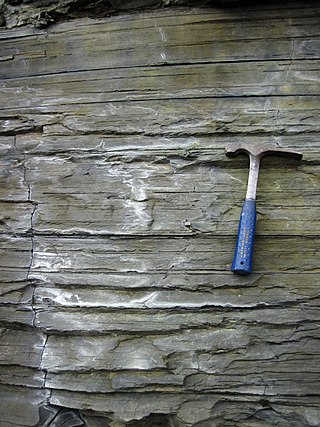
Shale is a fine-grained, clastic sedimentary rock formed from mud that is a mix of flakes of clay minerals (hydrous aluminium phyllosilicates, e.g. kaolin, Al2Si2O5(OH)4) and tiny fragments (silt-sized particles) of other minerals, especially quartz and calcite. Shale is characterized by its tendency to split into thin layers (laminae) less than one centimeter in thickness. This property is called fissility. Shale is the most common sedimentary rock.

Southern California is a geographic and cultural region that generally comprises the southern portion of the U.S. state of California. It includes the Los Angeles metropolitan area as well as the Inland Empire. The region generally contains ten of California's 58 counties: Imperial, Kern, Los Angeles, Orange, Riverside, San Bernardino, San Diego, Santa Barbara, San Luis Obispo, and Ventura counties.

The San Andreas Fault is a continental right-lateral strike-slip transform fault that extends roughly 1,200 kilometers (750 mi) through the U.S. state of California. It forms part of the tectonic boundary between the Pacific Plate and the North American Plate. Traditionally, for scientific purposes, the fault has been classified into three main segments, each with different characteristics and a different degree of earthquake risk. The average slip rate along the entire fault ranges from 20 to 35 mm per year.
Lakeport is an incorporated city and the county seat of Lake County, California. This city is 125 miles (201 km) northwest of Sacramento. Lakeport is on the western shore of Clear Lake, at an elevation of 1,355 feet (413 m). The population was 5,026 at the 2020 census, up from 4,753 at the 2010 census.

The Mojave Desert is a desert in the rain shadow of the southern Sierra Nevada mountains and Transverse Ranges in the Southwestern United States. Named for the indigenous Mohave people, it is located primarily in southeastern California and southwestern Nevada, with small portions extending into Arizona and Utah.
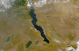
A rift valley is a linear shaped lowland between several highlands or mountain ranges produced by the action of a geologic rift. Rifts are formed as a result of the pulling apart of the lithosphere due to extensional tectonics. The linear depression may subsequently be further deepened by the forces of erosion. More generally the valley is likely to be filled with sedimentary deposits derived from the rift flanks and the surrounding areas. In many cases rift lakes are formed. One of the best known examples of this process is the East African Rift. On Earth, rifts can occur at all elevations, from the sea floor to plateaus and mountain ranges in continental crust or in oceanic crust. They are often associated with a number of adjoining subsidiary or co-extensive valleys, which are typically considered part of the principal rift valley geologically.

The M49 is a motorway in England that links the M4 (J22) with the M5 (J18A). The southern end is on the outskirts of Avonmouth and the northern end is immediately to the east of the Prince of Wales Bridge which was constructed at the same time 1996. It is 5 miles (8 km) long and unique in that it is only accessible from other motorways.

Montclair is a hillside neighborhood in Oakland, California, United States. Montclair is located along the western slope of the Oakland Hills from a valley formed by the Hayward Fault to the upper ridge of the hills.

Route 27 is a 73.44-mile-long (118.19 km) south–north state highway in eastern Massachusetts. Its southern terminus is at Route 106 in Kingston and its northern terminus is at Route 4 in Chelmsford. Along the way it intersects several major highways including Route 24 in Brockton, U.S. Route 1 in Walpole, Route 9 in Natick, US 20 in Wayland, and Route 2 in Acton.

The Sawtooth Range is a mountain range of the Rocky Mountains in central Idaho, United States, reaching a maximum elevation of 10,751 feet (3,277 m) at the summit of Thompson Peak. It encompasses an area of 678 square miles (1,756 km2) spanning parts of Custer, Boise, Blaine, and Elmore counties, and is bordered to the east by the Sawtooth Valley. Much of the mountain range is within the Sawtooth Wilderness, part of the Sawtooth National Recreation Area and Sawtooth National Forest.
The Edgar Dam is an earthfill embankment saddle dam without a spillway, located offstream in the South West region of Tasmania, Australia.

The Robert C. Maynard Institute for Journalism Education (MIJE) is an American non-profit organization that trains journalists to become investigative journalists, editors, newspaper managers, and media entrepreneurs. The organization seeks to increase diversity, equity, and inclusion in newsrooms to diversify coverage of the news itself, creating a more complex and representative picture of the American news landscape.

The Assabet River Rail Trail (ARRT) is a partially-completed multi-use rail trail running through the cities and towns of Marlborough, Hudson, Stow, Maynard, and Acton, Massachusetts, United States. It is a conversion of the abandoned Marlborough Branch of the Fitchburg Railroad. The right-of-way parallels the Assabet River in the trail's midsection. At the north end it veers north to the South Acton MBTA train station while the south end veers south to Marlborough. When fully completed, the end-to-end length will be 12.5 miles (20.1 km). As of June 2020, the southwest 5.1-mile (8.2 km) portion of the trail from Marlborough to Hudson and the northeast 3.4-mile (5.5 km) portion running from the South Acton MBTA station to the Maynard–Stow border are completed. No current plans exist for paving the 4.0-mile (6.4 km) gap in Stow and Hudson between the two trail ends.

Kentucky Route 98 is a 13.910-mile-long (22.386 km) state highway in Kentucky that runs from Kentucky Route 100 in Scottsville to Kentucky Route 100 southwest of Fountain Run.
The 2019 Ridgecrest earthquakes of July 4 and 5 occurred north and northeast of the town of Ridgecrest, California located in Kern County and west of Searles Valley. They included three initial main shocks of magnitudes 6.4, 5.4, and 7.1, and many perceptible aftershocks, mainly within the area of the Naval Air Weapons Station China Lake. Eleven months later, a Mw 5.5 aftershock took place to the east of Ridgecrest. The first main shock occurred on Thursday, July 4 at 10:33 a.m. PDT, approximately 18 km (11.2 mi) ENE of Ridgecrest, and 13 km (8.1 mi) WSW of Trona, on a previously unnoticed NE-SW trending fault where it intersects the NW-SE trending Little Lake Fault Zone. This quake was preceded by several smaller earthquakes, and was followed by more than 1,400 detected aftershocks. The M 5.4 and M 7.1 quakes struck on Friday, July 5 at 4:08 a.m. and 8:19 p.m. PDT approximately 10 km (6 miles) to the northwest. The latter, now considered the mainshock, was the most powerful earthquake to occur in the state in 20 years. Subsequent aftershocks extended approximately 50 km (~30 miles) along the Little Lake Fault Zone.

White Pond is a 58.5 acre lake and reservoir within the towns of Stow and Hudson, in Middlesex County, Massachusetts. The lake has historically provided a source of drinking water to the town of Maynard, and Maynard maintains water rights to the pond and owns some of the land surrounding it. White Pond is adjacent to Lake Boon but their waters are not connected.