Related Research Articles

The San Andreas Fault is a continental transform fault that extends roughly 1,200 kilometers (750 mi) through California. It forms the tectonic boundary between the Pacific Plate and the North American Plate, and its motion is right-lateral strike-slip (horizontal). The fault divides into three segments, each with different characteristics and a different degree of earthquake risk. The slip rate along the fault ranges from 20 to 35 mm /yr.

Paul William Walker IV was an American actor. He is best known for his role as Brian O'Conner in the Fast & Furious franchise.

Owens Valley is an arid valley of the Owens River in eastern California in the United States. It is located to the east of the Sierra Nevada, west of the White Mountains and Inyo Mountains, and north of the Mojave Desert. It sits on the west edge of the Great Basin. The mountain peaks on the West side reach above 14,000 feet (4,300 m) in elevation, while the floor of the Owens Valley is about 4,000 feet (1,200 m), making the valley the deepest in the United States. The Sierra Nevada casts the valley in a rain shadow, which makes Owens Valley "the Land of Little Rain." The bed of Owens Lake, now a predominantly dry endorheic alkali flat, sits on the southern end of the valley.

The Mendocino Fracture Zone is a fracture zone and transform boundary over 4000 km long, starting off the coast of Cape Mendocino in far northern California. It runs westward from a triple junction with the San Andreas Fault and the Cascadia subduction zone to the southern end of the Gorda Ridge. It continues on west of its junction with the Gorda Ridge, as an inactive remnant section which extends for several hundred miles.

The Walker Lane is a geologic trough roughly aligned with the California/Nevada border southward to where Death Valley intersects the Garlock Fault, a major left lateral, or sinistral, strike-slip fault. The north-northwest end of the Walker Lane is between Pyramid Lake in Nevada and California's Lassen Peak where the Honey Lake Fault Zone, the Warm Springs Valley Fault, and the Pyramid Lake Fault Zone meet the transverse tectonic zone forming the southern boundary of the Modoc Plateau and Columbia Plateau provinces. The Walker Lane takes up 15 to 25 percent of the boundary motion between the Pacific Plate and the North American Plate, the other 75 percent being taken up by the San Andreas Fault system to the west. The Walker Lane may represent an incipient major transform fault zone which could replace the San Andreas as the plate boundary in the future.

The Furnace Creek Fault Zone (FCFZ) is a geological fault that is located in Eastern California and southwestern Nevada. The right lateral-moving (dextral) fault extends for some 200 km (120 mi) between a connection with the Death Valley Fault Zone in the Amargosa Valley and northward to a termination in the Fish Lake Valley of southwest Nevada. The northern segment of the FCFZ is also referred to as the Fish Lake Valley Fault Zone. The FCFZ is considered an integral part of the Walker Lane.
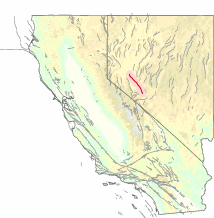
The Death Valley Fault Zone (DVFZ) is a right lateral-moving (dextral) geologic fault in eastern California. It runs from a connection with the Furnace Creek Fault Zone in the Amargosa Valley southward to a junction with the Garlock Fault. It is considered an integral part of the Walker Lane.
The Benton Spring Fault is a right lateral-moving (dextral) geologic fault located in western Nevada. It is considered an integral part of the Walker Lane.

The Pyramid Lake Fault Zone is an active right lateral-moving (dextral) geologic fault located in western Nevada. It is considered an integral part of the Walker Lane.

The Honey Lake Fault Zone is a right lateral-moving (dextral) geologic fault extends through northwestern Nevada and northeastern California. It is considered an integral part of the Walker Lane.

Kyle Andrew Walker is an English professional footballer who plays as a right-back for Premier League club Manchester City and the England national team.

The Brothers Fault Zone (BFZ) is the most notable of a set of northwest-trending fault zones including the Eugene–Denio, McLoughlin, and Vale zones that dominate the geological structure of most of Oregon. These are also representative of a regional pattern of generally northwest-striking geological features ranging from Walker Lane on the California–Nevada border to the Olympic–Wallowa Lineament in Washington; these are generally associated with the regional extension and faulting of the Basin and Range Province, of which the BFZ is considered the northern boundary.

Most of central and northern California rests on a crustal block (terrane) that is being torn from the North American continent by the passing Pacific plate of oceanic crust. Southern California lies at the southern end of this block, where the Southern California faults create a complex and even chaotic landscape of seismic activity.
Sebastian Walker is an investigative journalist and an Emmy Award-winning broadcast journalist, who is currently a correspondent and Middle-East bureau chief for VICE News Tonight on HBO.
The Denholme Clough Fault is a small fault located in Denholme, England. The fault is approximately 500 metres (1,600 ft) long. The fault has produced no appreciable earthquake history, but it is still subject to stresses that may cause it to slip. The maximum earthquake arising from a slip of this fault has been estimated to be below magnitude 3. The Denholme Clough Fault is part of the Pennine anticline and is partially visible from the surface.
The geology of Nevada began to form in the Proterozoic at the western margin of North America. Terranes accreted to the continent as a marine environment dominated the area through the Paleozoic and Mesozoic periods. Intense volcanism, the horst and graben landscape of the Basin and Range Province originating from the Farallon Plate, and both glaciers and valley lakes have played important roles in the region throughout the past 66 million years.
The 2019 Ridgecrest earthquakes of July 4 and 5 occurred north and northeast of the town of Ridgecrest, California and west of Searles Valley. They included three initial main shocks of Mw magnitudes 6.4, 5.4, and 7.1, and many perceptible aftershocks, mainly within the area of the Naval Air Weapons Station China Lake. Eleven months later, a Mw 5.5 aftershock took place to the east of Ridgecrest. The first main shock occurred on July 4 at 10:33 a.m. PDT, approximately 18 km (11.2 mi) ENE of Ridgecrest, and 13 km (8.1 mi) WSW of Trona, on a previously unnoticed NE-SW trending fault where it intersects the NW-SE trending Little Lake Fault Zone. This quake was preceded by several smaller earthquakes, and was followed by more than 1,400 detected aftershocks. The M 5.4 and M 7.1 quakes struck on July 5 at 4:08 a.m. and 8:19 p.m. PDT approximately 10 km (6 miles) to the northwest. The latter, now considered the mainshock, was the most powerful earthquake to occur in the state in 20 years. Subsequent aftershocks extended approximately 50 km (~30 miles) along the Little Lake Fault Zone.

On May 15, 2020 at 4:03:27 local time, a magnitude 6.5 earthquake struck ~35 miles (56 km) west of Tonopah, Nevada in the Monte Cristo Range near the California-Nevada border. It was Nevada's largest earthquake in 66 years.

In 1954, the state of Nevada was struck by a series of earthquakes that began with several M 6.0s in July and August that preceded the M 7.3 main shock, and an M 6.9 on December 12. All five earthquakes remain some of the largest in the state, and the largest since the Cedar Mountain earthquake of 1932 and Pleasant Valley event in 1915. The earthquake was felt throughout much of the western United States.

The Cedar Mountain earthquake of 1932 was one of the largest seismic events in the US state of Nevada. The 7.2 magnitude earthquake struck at the base of Cedar Mountain in Western Nevada. Shaking from this earthquake was felt as far as Oregon, Southern California, and the Rocky Mountains area. Nevada is the third most seismically active state in the United States due to ongoing rifting occurring within the North American Plate. Extension or thinning of the crust has resulted in numerous faults accommodating strain, at the same time, producing earthquakes. Since the earthquake took place in a remote area of the state, there were slight damages but no deaths were reported.
References
- ↑ Steven G. Wesnousky (June 2005). "Active faulting in the Walker Lane". Tectonics . 24 (3): 5. Bibcode:2005Tecto..24.3009W. doi:10.1029/2004TC001645. ISSN 0278-7407. Wikidata Q96749837.
| | This article about a specific United States geological feature is a stub. You can help Wikipedia by expanding it. |
| | This Nevada-related article is a stub. You can help Wikipedia by expanding it. |