Related Research Articles

The San Andreas Fault is a continental transform fault that extends roughly 1,200 kilometers (750 mi) through California. It forms the tectonic boundary between the Pacific Plate and the North American Plate, and its motion is right-lateral strike-slip (horizontal). The fault divides into three segments, each with different characteristics and a different degree of earthquake risk. The slip rate along the fault ranges from 20 to 35 mm /yr. It was formed by a transform boundary.

The 1872 Owens Valley earthquake – also known as the Lone Pine earthquake – struck on March 26 at 02:30 local time in the Owens Valley, with the epicenter near the town of Lone Pine. Its magnitude has been estimated at Mw 7.4 to 7.9, with a maximum Mercalli Intensity of X (Extreme). It was one of the largest earthquakes to hit California in recorded history and was similar in size to the 1906 San Francisco earthquake. Twenty-seven people were killed and fifty-six were injured.

The Hayward Fault Zone is a geologic fault zone capable of generating destructive earthquakes. This fault is about 74 mi (119 km) long, situated mainly along the western base of the hills on the east side of San Francisco Bay. It runs through densely populated areas, including Richmond, El Cerrito, Berkeley, Oakland, San Leandro, Castro Valley, Hayward, Union City, Fremont, and San Jose.
Induced seismicity refers to typically minor earthquakes and tremors that are caused by human activity that alters the stresses and strains on the Earth's crust. Most induced seismicity is of a low magnitude. A few sites regularly have larger quakes, such as The Geysers geothermal plant in California which averaged two M4 events and 15 M3 events every year from 2004 to 2009. The Human-Induced Earthquake Database (HiQuake) documents all reported cases of induced seismicity proposed on scientific grounds and is the most complete compilation of its kind.

The Diablo Canyon Power Plant is an electricity-generating nuclear power plant near Avila Beach in San Luis Obispo County, California. Since the permanent shutdown of the San Onofre Nuclear Generating Station in 2013, Diablo Canyon is the only operational nuclear plant left in the state. The plant has two Westinghouse-designed 4-loop pressurized-water nuclear reactors operated by Pacific Gas & Electric (PG&E).

The San Onofre Nuclear Generating Station (SONGS) is a permanently closed nuclear power plant located south of San Clemente, California, on the Pacific coast, in Nuclear Regulatory Commission Region IV. The plant was shut down in 2013 after replacement steam generators failed; it is currently in the process of decommissioning.
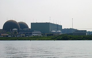
The North Anna Nuclear Generating Station is a nuclear power plant on a 1,075-acre (435 ha) site in Louisa County, Virginia, in the Mid-Atlantic United States. The site is operated by Dominion Generation company and is jointly owned by the Dominion Virginia Power corporation (88.4%) and by the Old Dominion Electric Cooperative (11.6%).

The Fukuoka earthquake struck Fukuoka Prefecture, Japan at 10:53 am JST on March 20, 2005, and lasted for approximately 1 minute. The Japan Meteorological Agency (JMA) measured it as peaking at a magnitude of 7.0 (6.6) and named it and its subsequent aftershocks the Fukuoka Prefecture western offshore earthquakes. The quake occurred along a previously unknown fault in the Genkai Sea, North of Fukuoka city, and the residents of Genkai island were forced to evacuate as houses collapsed and landslides occurred in places. Investigations subsequent to the earthquake determined that the new fault was most likely an extension of the known Kego fault that runs through the centre of the city.
The Abalone Alliance (1977–1985) was a nonviolent civil disobedience group formed to shut down the Pacific Gas and Electric Company's Diablo Canyon Power Plant near San Luis Obispo on the central California coast in the United States. They modeled their affinity group-based organizational structure after the Clamshell Alliance which was then protesting the Seabrook Nuclear Power Plant in coastal New Hampshire. The group of activists took the name "Abalone Alliance" referring to the tens of thousands of wild California Red Abalone that were killed in 1974 in Diablo Cove when the unit's plumbing had its first hot flush.

The Calaveras Fault is a major branch of the San Andreas Fault System that is located in northern California in the San Francisco Bay Area. Activity on the different segments of the fault includes moderate and large earthquakes as well as aseismic creep. The last large event was the 1984 Morgan Hill event and the last moderate earthquake was the 2007 Alum Rock event.

The Kashiwazaki-Kariwa Nuclear Power Plant is a large, modern nuclear power plant on a 4.2-square-kilometer (1,000-acre) site including land in the towns of Kashiwazaki and Kariwa in Niigata Prefecture, Japan on the coast of the Sea of Japan, from where it gets cooling water. The plant is owned and operated by Tokyo Electric Power Company (TEPCO).
The Hosgri Fault is an offshore fault zone located near the Central Coast of California in San Luis Obispo County. The main fault stretches for about 87 miles (140 km), and is located nearest to the coastal communities of Cambria, San Simeon, Morro Bay, Baywood Park-Los Osos and Avila Beach. The fault system is some 260 mi (420 km) long, and is a right-lateral strand of the San Andreas Fault system.

The 1986 Chalfant Valley earthquake struck southern Mono County near Bishop and Chalfant, California at 07:42:28 Pacific Daylight Time on July 21. With a moment magnitude of 6.2 and a maximum Mercalli intensity of VI (Strong), the shock injured two people and caused property damage estimated at $2.7 million in the affected areas. There was a significant foreshock and aftershock sequence that included a few moderate events, and was the last in a series of three earthquakes that affected southern California and the northern Owens Valley in July 1986.

Although the eastern United States is not as seismically active as regions near plate boundaries, large and damaging earthquakes do occur there. Furthermore, when these rare eastern U.S. earthquakes occur, the areas affected by them are much larger than for western U.S. earthquakes of the same magnitude. Thus, earthquakes represent at least a moderate hazard to East Coast cities, including New York City and adjacent areas of very high population density.
San Luis Obispo Mothers for Peace (SLOMFP) is a participant in the anti-nuclear movement in California which is depicted in the anti-nuclear documentary film Dark Circle during the early years of protest opposing the Diablo Canyon Power Plant (DCPP). DCPP was the first nuclear power plant to have its license suspended, which resulted from disclosure that they installed safety systems incorrectly. In Dark Circle, Mothers for Peace takes credit for delays which prevented the plant from going online prior to the discovery of the errors.
Diablo Canyon (Nuclear) Power Plant, located in San Luis Obispo County California, was originally designed to withstand a 6.75 magnitude earthquake from four faults, including the nearby San Andreas and Hosgri faults, but was later upgraded to withstand a 7.5 magnitude quake. It has redundant seismic monitoring and a safety system designed to shut it down promptly in the event of significant ground motion.
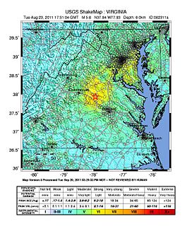
On August 23, 2011, a magnitude 5.8 earthquake hit the Piedmont region of the U.S. state of Virginia at 1:51:04 p.m. EDT. The epicenter, in Louisa County, was 38 mi (61 km) northwest of Richmond and 5 mi (8 km) south-southwest of the town of Mineral. It was an intraplate earthquake with a maximum perceived intensity of VII on the Mercalli intensity scale. Several aftershocks, ranging up to 4.5 Mw in magnitude, occurred after the main tremor.

The Concord Fault is a geologic fault in the San Francisco Bay Area. It is so called because it is located under the city of Concord. It is connected to, and considered to be part of, the same fault zone as the Green Valley fault, which lies just a few miles to the north across the Suisun Bay. The fault is situated at the east of West Napa Fault and extends from Mount Diablo to the Carquinez Strait, an approximately 11 mile long distance. Like most other faults in this area, the Concord Fault is a strike-slip fault, moving approximately 2.7 to 3.6 millimeters a year.
The Lompoc earthquake of 1927 occurred at 5:49 a.m. Pacific Standard Time (PST), on November 4 with an epicenter off the coast of Lompoc, Santa Barbara County in Southern California. This is one of the largest earthquakes to have occurred offshore, having a moment magnitude between 7.1 and 7.3. The earthquake may have originated along the Hosgri Fault, an entirely offshore structure. Shaking from the earthquake and an unusually large tsunami caused some damage to communities near the earthquake. Due to its location and the area being sparsely populated at the time, there were no human fatalities reported. It is the only California generated tsunami recorded in Hawaii.
References
- ↑ ScienceDaily:Revised Seismotectonic Model for California Central Coast: More Complex Than Previously Thought
- ↑ Jeanne L. Hardebeck (February 2013). "Geometry and Earthquake Potential of the Shoreline Fault, Central California". Bulletin of the Seismological Society of America . 103 (1): 447–462. Bibcode:2013BuSSA.103..447H. doi:10.1785/0120120175. ISSN 1943-3573. Wikidata Q59849516.
- ↑ Santa Maria Times:Supervisors request delay for Diablo relicensing